Albania: Air Bases and Military Airfields
For historical information only, do not use for navigation or aviation purposes!
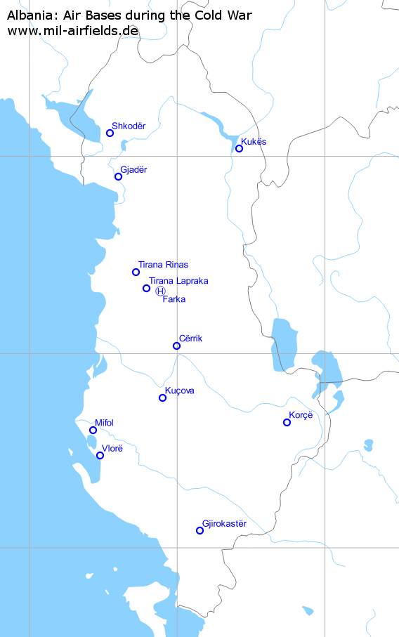
Military airfields in Albania (12)
Cërrik: Airfield
Elbasan
For historical information only, do not use for navigation or aviation purposes!
| Coordinates | N410221 E0195949 ca. (WGS84) Google Maps |
| Elevation | 351 ft |
Location of airfield
Probably northeast of Cërrik. The location is taken from TPC maps. It cannot be clearly identified on Google Earth.
Usage during the Cold War
Reserve airbase?
Use today
Probably closed.
Airfields in the vicinity
- 195°/31km Kuçova: Air Base (Kuçovë, Kucova, Berat/Kucove)
- 343°/32km Farka: Heliport (Tirana-Farka, Farke)
- 332°/37km Tirana: Lapraka Airfield
Farka: Heliport
Tirana-Farka, Farke
For historical information only, do not use for navigation or aviation purposes!
| Coordinates | N411856 E0195308 (WGS84) Google Maps |
| Location indicator | LAFK |
Location of airfield
6 km east-southeast of Tirana city center.
Usage during the Cold War
Military heliport
Airfields in the vicinity
- 284°/8km Tirana: Lapraka Airfield
- 309°/18km Tirana: Rinas Airport
- 163°/32km Cërrik: Airfield (Elbasan)
Gjadër: Air Base
Gjader, Lezhë, Lezha, Gramsh
For historical information only, do not use for navigation or aviation purposes!
| Coordinates | N415343 E0193555 (WGS84) Google Maps |
| Elevation | 23 ft |
| Location indicator | LAGJ |
Location of airfield
13 km north-northwest of Lezhë, northeast of Gjadër.
Usage during the Cold War
Albanian Air Force airbase.
Use today
Closed.
Runways
- 16/34: 2800 m x 60 m Concrete
- 17/35: 2200 m x 28 m Concrete Reserve
Taxiways, aprons
At its southern end, runway 17/35 changes into a taxiway, which crosses the river Drin with a bridge. It leads to an underground aircraft storage.
Links
- Shenyang F-6 in the underground storage
- Chengdu F-7A in the underground storage
- Garat ne Gjader, Racing in Albania - Video about car racing at the Gjadër airbase.
Airfields in the vicinity
- 349°/25km Shkodër: Airfield
Gjirokastër: Airfield
Gjirokastra
For historical information only, do not use for navigation or aviation purposes!
| Coordinates | N400514 E0200911 (WGS84) Google Maps |
| Elevation | 666 ft |
Location of airfield
Northeast of Gjirokastër.
Runways
- 14/32: 1500 m Grass
Korçë: Air Base
Korce Northwest, Korça
For historical information only, do not use for navigation or aviation purposes!
| Coordinates | N403850 E0204427 (WGS84) Google Maps |
| Location indicator | LAKO |
Location of airfield
4 km northwest of Korçë city center.
Usage during the Cold War
Reserve airfield?
Runways
- 01/19: 2300 m Grass
Kuçova: Air Base
Kuçovë, Kucova, Berat/Kucove
For historical information only, do not use for navigation or aviation purposes!
| Coordinates | N404621 E0195405 (WGS84) Google Maps |
| Elevation | 135 ft |
| Location indicator | LAKV |
Location of airfield
4 km south-southwest of Kuçova.
Usage during the Cold War
Albanian Air Force airbase.
Use today
Albanian Air Force airbase.
Runways
- 14/32: 2840 m x 67 m Beton
- 09/27: 2500 m Reserve
- 14/32: 1070 m closed
Taxiways, aprons
Runway 09/27 ends in the east at an underground aircraft storage.
Links
Airfields in the vicinity
- 015°/31km Cërrik: Airfield (Elbasan)
Kukës: Airfield
Kukes
For historical information only, do not use for navigation or aviation purposes!
| Coordinates | N420210 E0202457 (WGS84) Google Maps |
| Elevation | 1552 ft |
Location of airfield
5 km south-southwest of Kukës.
Runways
- 01/19: 1500 m Grass
Mifol: Airfield
Akerni, Pish Poro
For historical information only, do not use for navigation or aviation purposes!
| Coordinates | N403625 E0192538 (WGS84) Google Maps |
| Elevation | 36 ft |
Usage during the Cold War
Reserve airfield
Use today
Probably closed.
Runways
- 13/31: 3500 m Grass
Links
Airfields in the vicinity
- 165°/15km Vlorë: Airfield
Shkodër: Airfield
For historical information only, do not use for navigation or aviation purposes!
| Coordinates | N420653 E0193230 (WGS84) Google Maps |
| Elevation | 98 ft |
Location of airfield
6 km northeast of Shkodër city center.
Runways
- 18/36: 1500 m Grass
Links
Airfields in the vicinity
Tirana: Lapraka Airfield
For historical information only, do not use for navigation or aviation purposes!
| Coordinates | N411958 E0194733 (WGS84) Google Maps |
| Elevation | 299 ft |
Location of airfield
Formerly in front of the northwestern city limits; it seems that the city was extended to this area over the last years.
Use today
Closed.
Runways
- 12/30: ca. 1100 m
Airfields in the vicinity
- 104°/8km Farka: Heliport (Tirana-Farka, Farke)
- 327°/11km Tirana: Rinas Airport
- 152°/37km Cërrik: Airfield (Elbasan)
Tirana: Rinas Airport
For historical information only, do not use for navigation or aviation purposes!
| Coordinates | N412453 E0194314 (WGS84) Google Maps |
| Elevation | 126 ft |
| Location indicator | LATI |
Location of airfield
12 km northwest of Tirana city center.
Usage during the Cold War
Joint use as airbase and international airport.
Use today
Air base and airport.
Runways
- 18/36
Airfields in the vicinity
- 147°/11km Tirana: Lapraka Airfield
- 129°/18km Farka: Heliport (Tirana-Farka, Farke)
Vlorë: Airfield
For historical information only, do not use for navigation or aviation purposes!
| Coordinates | N402832 E0192827 (WGS84) Google Maps |
| Elevation | 10 ft |
| Location indicator | LAVL |
Location of airfield
Northwest of Vlorë.
Use today
Closed.
Airfields in the vicinity
- 345°/15km Mifol: Airfield (Akerni, Pish Poro)
Unidentified Airfields
Internet sources mention three more airfields: Island of Sazan, Orishti and Shijak.- Island of Sezan: I could not identify any airfield installation on Google Earth. It seems that the topography of the island is generally unsuitable to build an airfield.
- I cannot find a location named Orishti. Obviously, the other sources have the same problem.
- In the area of Shijak, I could not identify any airfield. According to a US map from the year (ca.) 1960, there was an airfield southwest of Shijak, between the road Salmanaj-Rreth and the river Erzen, approximately at N4120 E01933. But Google Earth and other satellite pictures back to 1999 do not show appropriate installations or relicts. The internet sources say that this was a MiG base. But the maximum available length here would be 1,5 km (direction ca. 150°/330°), which would be quite short for jet operations.
Glossary
The following terms might help you for your own research on search engines. I'm not an expert for hungarian, so it is without warranty. Corrections and additions are welcome!
| Airbase | Baza ajrore |
| Aircraft | Aeroplan |
| Aircraft | Avion |
| Airfield | Pistën ajrore |
| Albania | Shqipëria |