For historical information only, do not use for navigation or aviation purposes!
| Coordinates | N522825 E0132406 (WGS84) Google Maps |
| Elevation | 164 ft |
| Location indicator | DDTF (195x), EDBB (196x-1995), EDDI (1995-2008) |
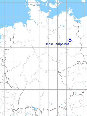
Germany during the Cold War Map
The history of the Cold War airfields: Berlin-Tempelhof Airport
Contents
Page 1: From the beginnings until 1945
Page 3: Tempelhof Airport: The 1950s
Page 4: Berlin Tempelhof Central Airport from 1960 to 1993 ← you are here
In the 1960s
Situation
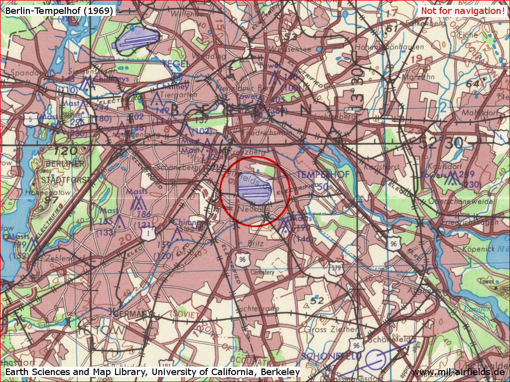
Berlin Tempelhof Airport on a US map from 1969 - Earth Sciences and Map Library, University of California, Berkeley
Source: Earth Sciences and Map Library, University of California, Berkeley, http://www.lib.berkeley.edu/libraries/earth-sciences-library
In the 1970s
Situation
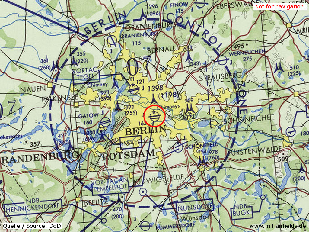
Former Berlin Tempelhof Airport on a map of the US Department of Defense from 1972
Source: ONC E-2 (1972), Perry-Castañeda Library Map Collection, University of Texas at Austin, https://legacy.lib.utexas.edu/maps/
In the 1980s and early 1990s
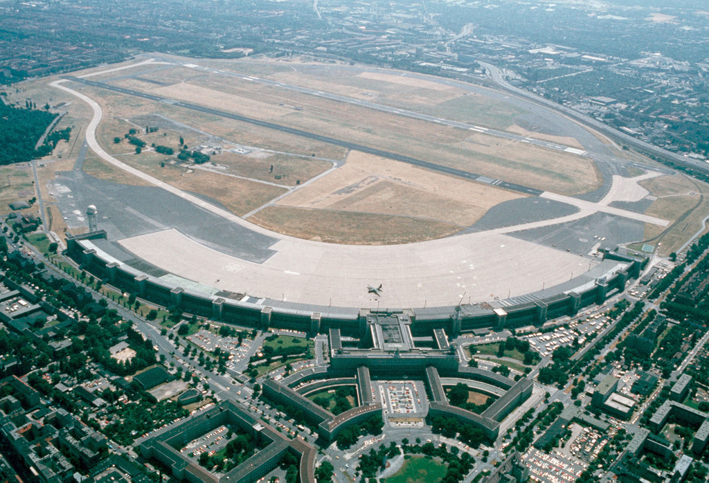
Overview
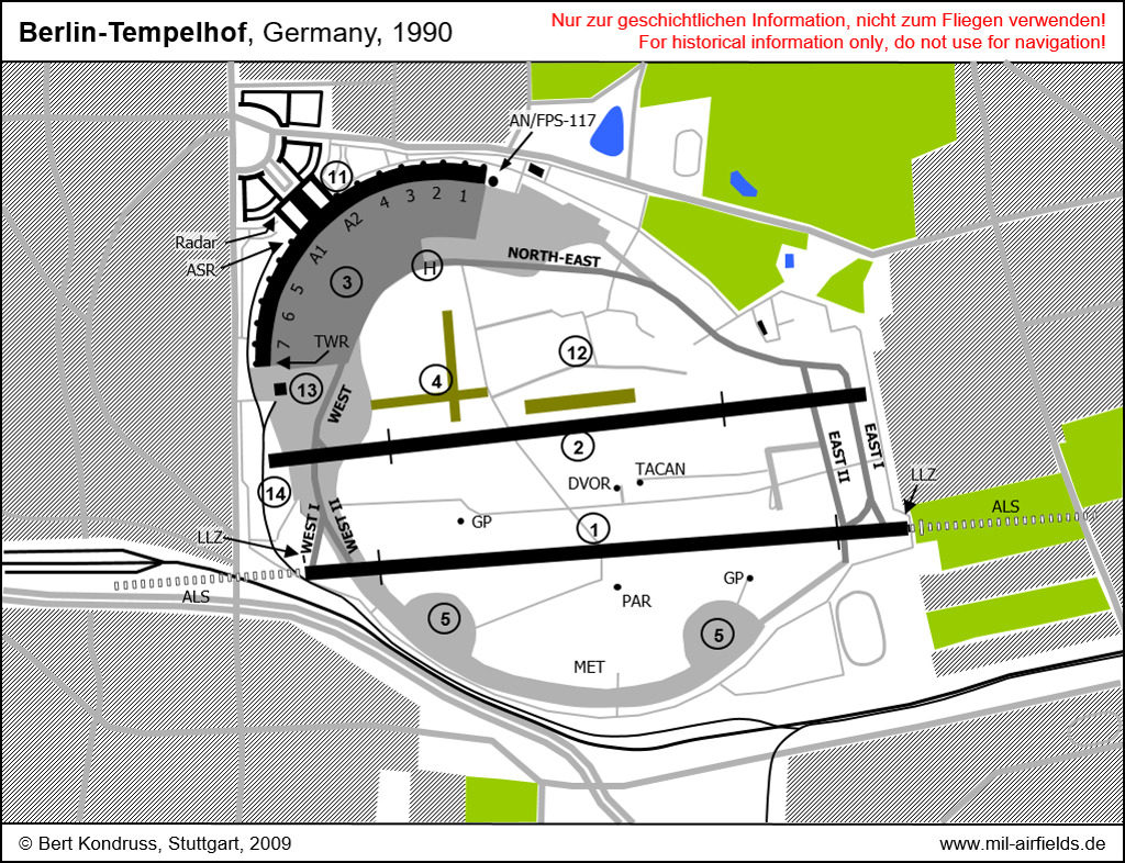
Runways, taxiways
| (1) | Runway 09R/27L |
| (2) | Runway 09L/27R |
| (3) | Apron |
| (4) | Helicopter lanes |
| (5) | Old take-off platforms |
Installations
| (11) | Main Building |
| (12) | Remains of the old terminal building |
| (13) | Cargo Hangar |
| (14) | Railway Siding |
Aeronautical installations
| ALS | Approach Lights |
| AN/FPS-117 | Radar Tower |
| ASR | Airport Surveillance Radar |
| DVOR | VHF Omindirectional Radio Range navigation station |
| GP | ILS Glide Path |
| (H) | Helipad |
| LLZ | ILS Localizer |
| MET | Meteorological Station |
| TACAN | Tactical Air Navigation - Military navigation system |
| TWR | Control Tower |
Runways
During the 1980s:
- 09R/27L: 2116 m x 42,50 m
- 09L/27R: 2093 x 42,50 m
Radio beacons
Data for the year 1985:
- DVORTAC: 114.1 "TOF", ATIS
- VOT: 108.2 "Dots"
- Havel DVOR/DME: 113.3 "HVL"
- Lubars NDB: 413.5 "DLS"
- ILS27L: 109.5 "IDLB"
- Planter NDB: 327 "DIP", 270°, 1.9 NM to THR 27L
- ILS09R: 109.7 "IDBR"
- Helmholtz NDB: 347 "DBR", 090°, 3.59 NM to THR 09R
Radio communication
During the 1980s:
- Berlin Center 120.85, 353.8 South Corridor
- Berlin Center 125.3, 293.8 Center and North Corridor
- Berlin Center 125.5, 134.65
- Berlin Approach 120.95, 125.8, 132.65, 362.3
- Berlin Approach 120.7, 345.3 PAR 09R, 27L
- Berlin Departure 119.3, 372.0
- ATIS 114.1 TOF VORTAC
- Tempelhof Tower 118.1, 337.3, 356.0, 358.0
- Tempelhof Ground 121.9, 356.0
- Base Ops 386.9
- Berlin Radio 3479, 5661, 6598, 10084 SELCAL
Units
1990: US Army Aviation Detachment: 6 UH-1H, 1 C-12C, 2 UV-20A; 7350th ABG
Images
The 1980s
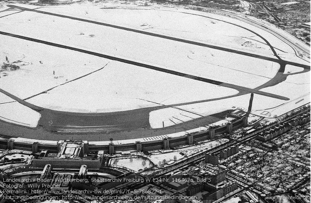
Aerial view March 1980
Source: Landesarchiv Baden-Württemberg, https://www.landesarchiv-bw.de/
Aerial picture from 14 October 1983
Source: US DoD, THOMAS FARR, https://www.archives.gov/
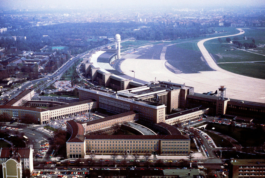
Main Building 01 June 1983
Source: US DoD, photographer: MASTER SERGEANT DON SUTHERLAND
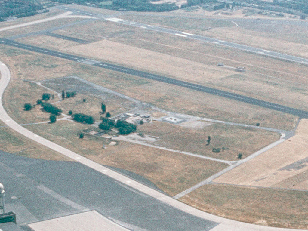
Relicts of the old airport 1983
Source: US DoD, THOMAS FARR
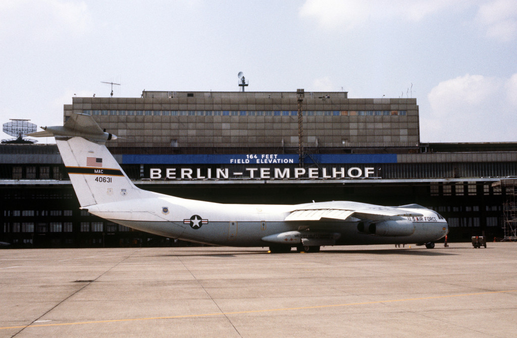
C-141B Starlifter of the US Air Force on the apron 01 June 1983
Source: US DoD, MSGT DON SUTHERLAND
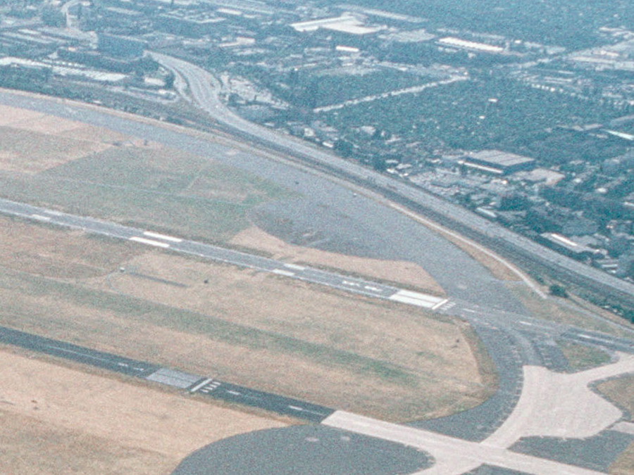
Southwestern take-off platform - Part of an aerial picture from 1983
Source: US DoD, THOMAS FARR
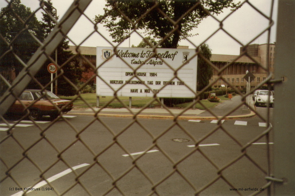
"Welcome to Tempelhof Central Airport" (1984)
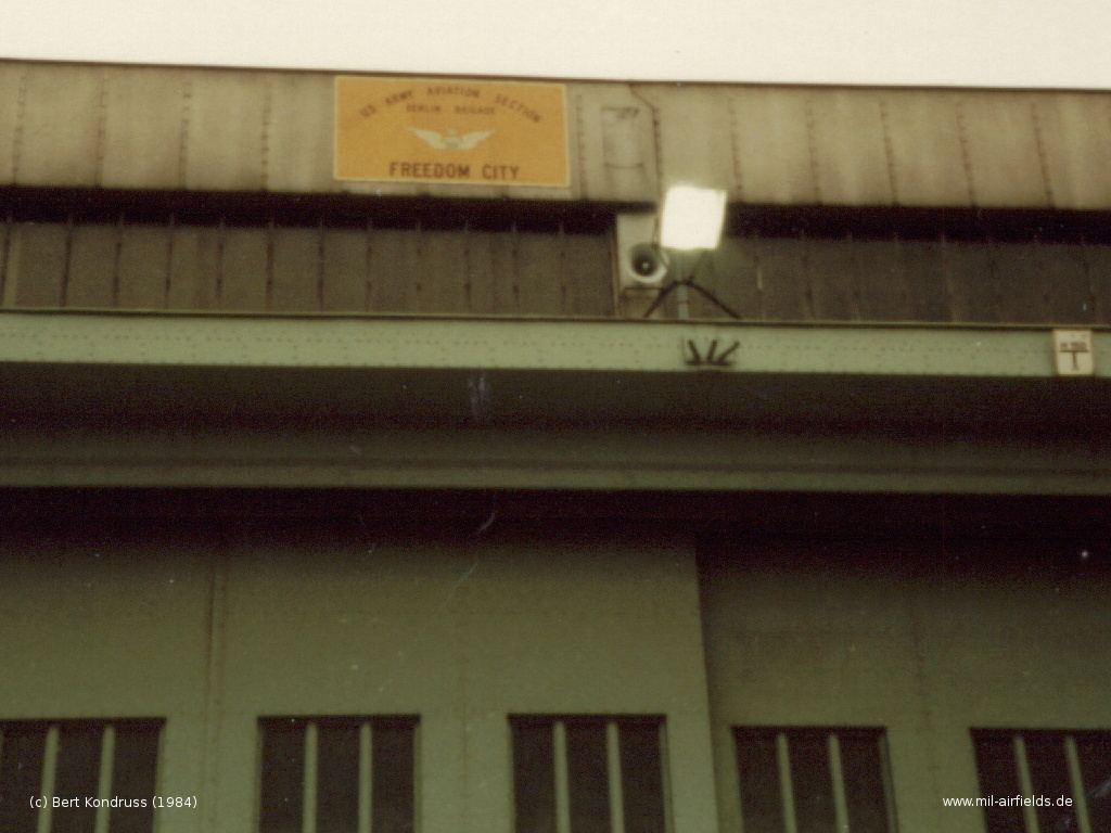
"US Army Aviation Section - Berlin Brigade - Freedom City"
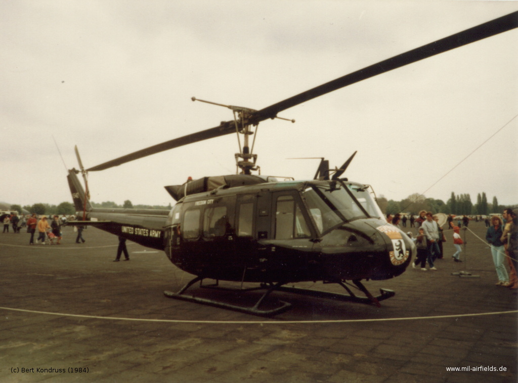
US Army Bell UH-1 Iroquois "Freedom City" (1984)
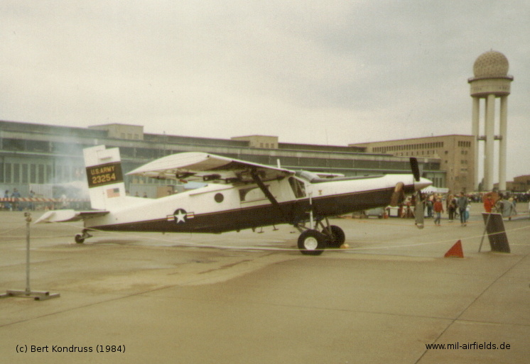
One of the two Pilatus UV-20 Chiricahua of the US Army in Berlin
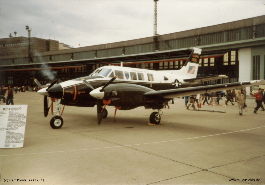
Beech U-21A King Air 66-18010 "Freedom City" (1984)
Sign at the gate (1987) (Source: DoD, MSGT PAT NUGENT)
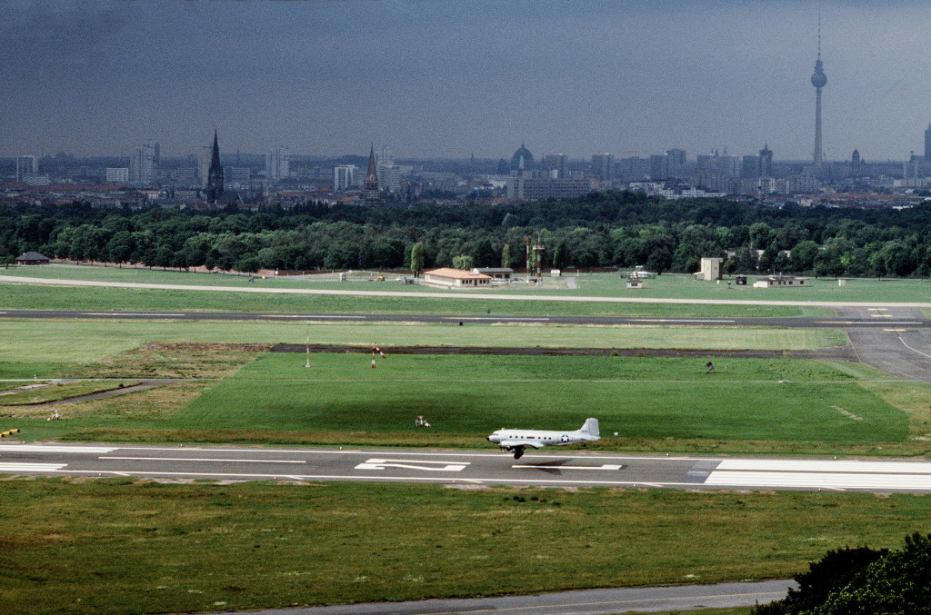
Runway 27L - Landing of a C-47 on runway 27L in 1988.
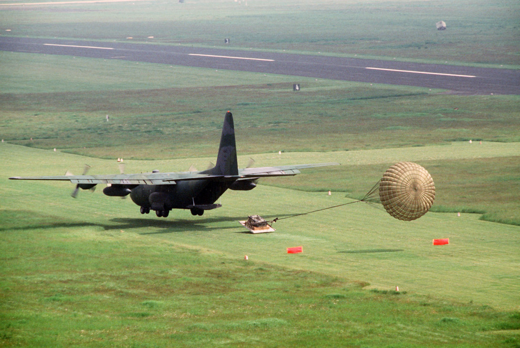
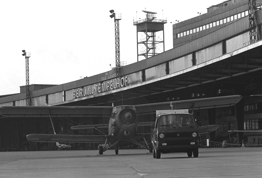
Helicopter lanes - On this picture, all three helicopter lanes can be seen. The aircraft is a C-130E Hercules from the 37th Tactical Airlift Squadron on the 14oct1988, using the low altitude parachute extraction system (LAPES) - Source: DoD, photographer MSGT PATRICK NUGENT
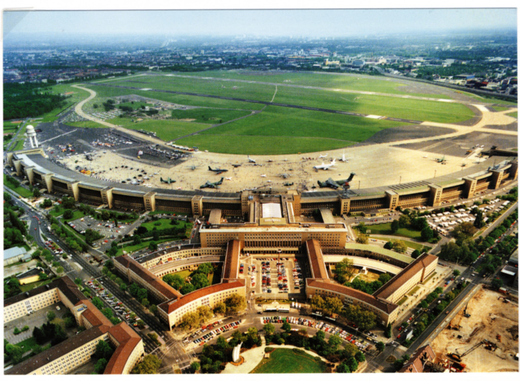
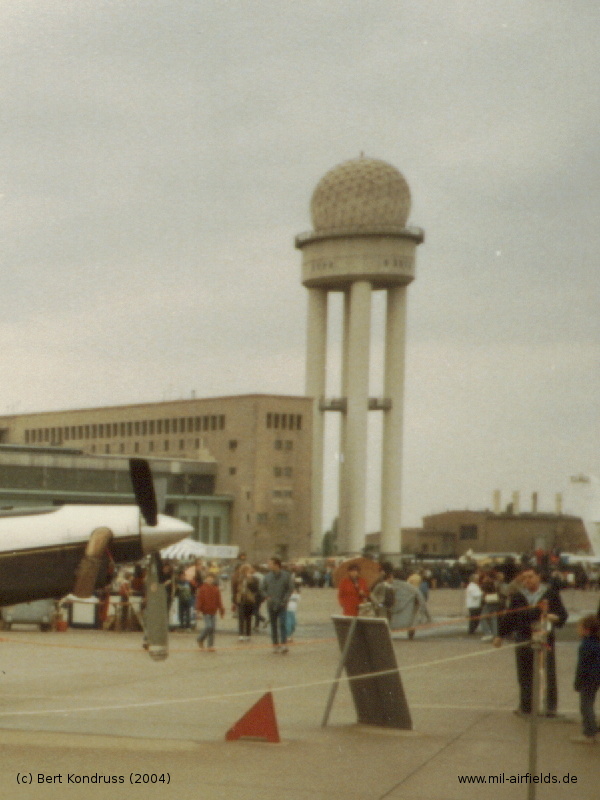
Aerial view from the open house 1989 (Photo: Berliner Flughäfen / Archiv)
Radar Equipment
Height Finder
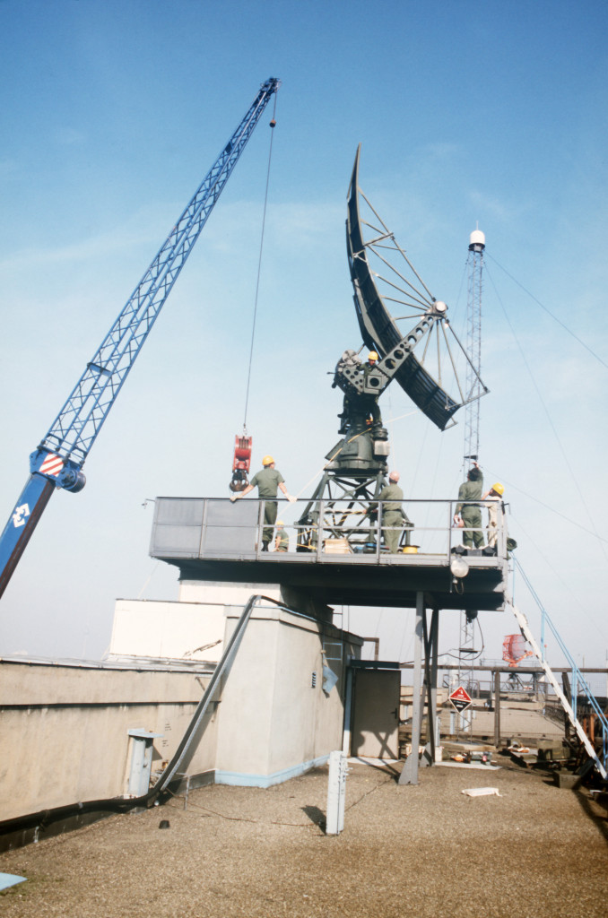
Removing the height finder in october 1984 (Photo: DoD, RAMI HARCSZTARK)
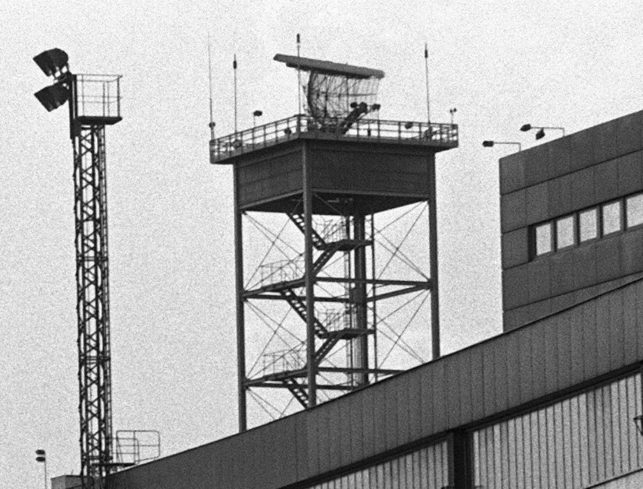
AN/FPS-117
The radar tower in 1984. The radom shows a segmented structure, which is different today.
Short before exchanging the radom?
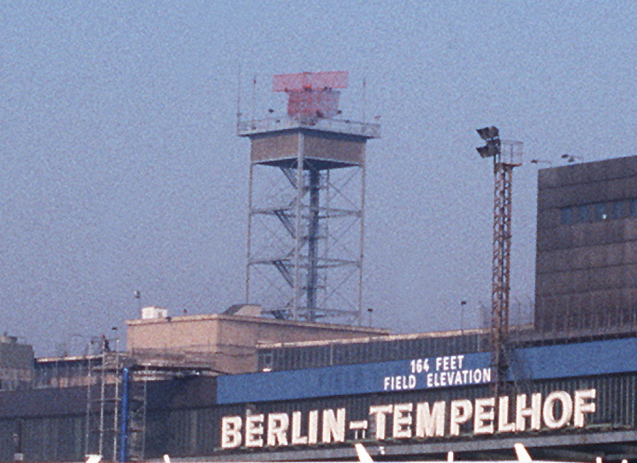
Aerodrome Surveillance Radar (ASR)
The ASR in 1983 (Photo: DoD, Thomas Farr)
ASR - The Airport Surveillance Radar (ASR) in 1987 (Source: DoD)
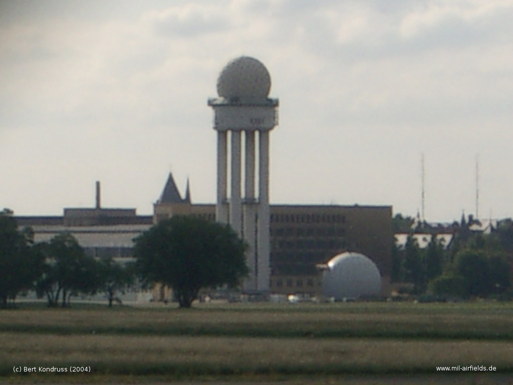
The empty radar tower in 2004 (Photo: Berliner Flughäfen)
Berlin Air Route Traffic Control Center (BARTCC) und Tempelhof Automated System (TAS)
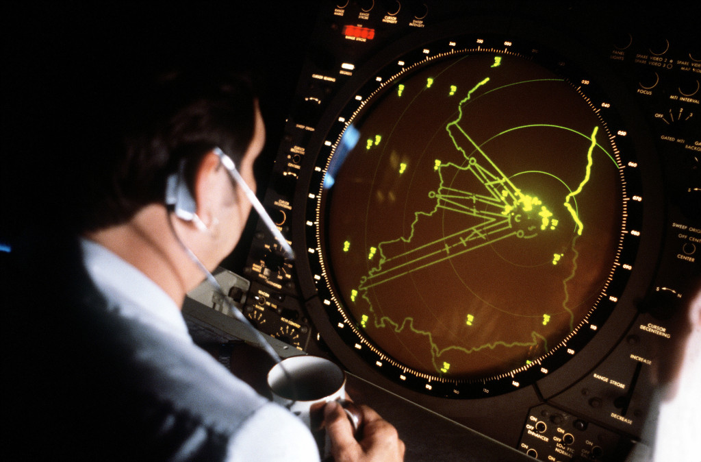
BARTCC control room (01 September 1982) - "TSGT James Elmore of the 1946th Communication Squadron is an air traffic approach controller at the Tempelhof Central Airport." (Photo: DoD, THOMAS FARR)
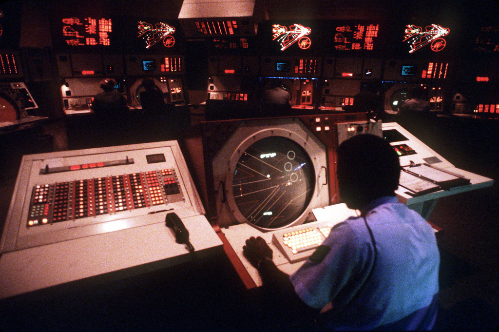
BARTCC control room (01 January 1986) - (Photo: DoD, CHIEF MASTER SGT. SUTHERLAND)
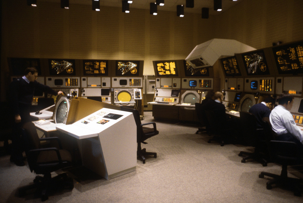
(Photo: DoD, THOMAS FARR)
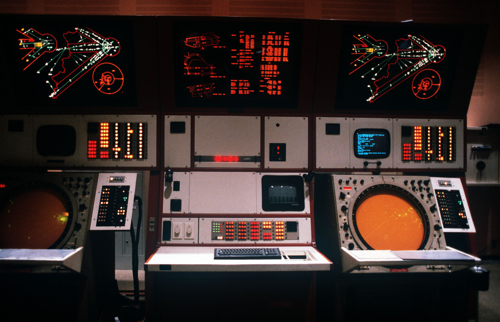
Radar console GPN-22 (Photo: DoD, THOMAS FARR)
Grafical display of the Tempelhof Automated System TAS (Photo: DoD, THOMAS FARR)
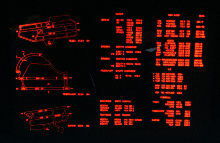
Airport information, radio frequencies and radio navigation aids (Photo: DoD, THOMAS FARR)
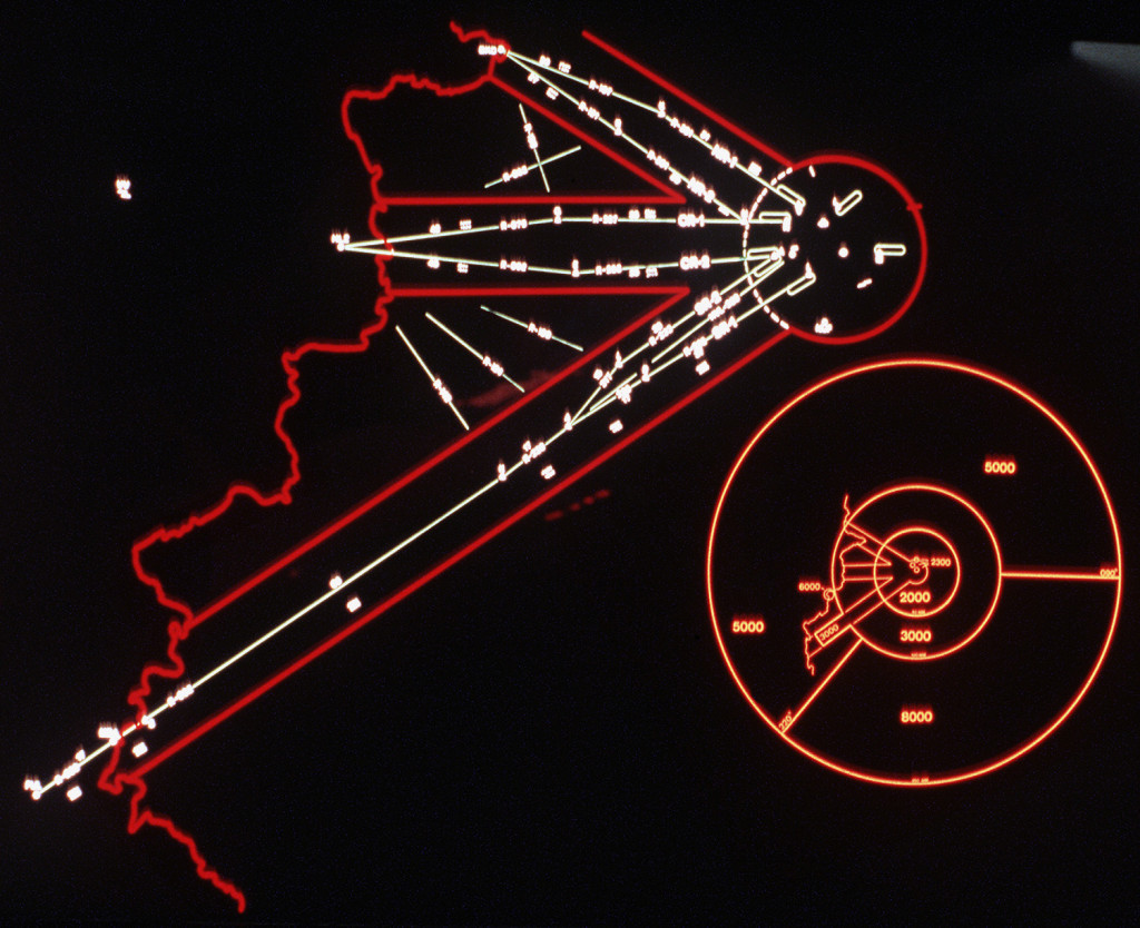
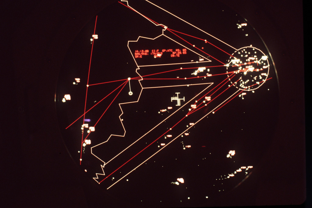
Radar Pictures
Radar picture from the 26jan1989 (Photo: DoD, CMSGT. DON SUTHERLAND)
Radar screen either from March 25th, 1986 or April 1st, 1987, probably from the AN/FPS-117 (Source: DoD, THOMAS FARR)
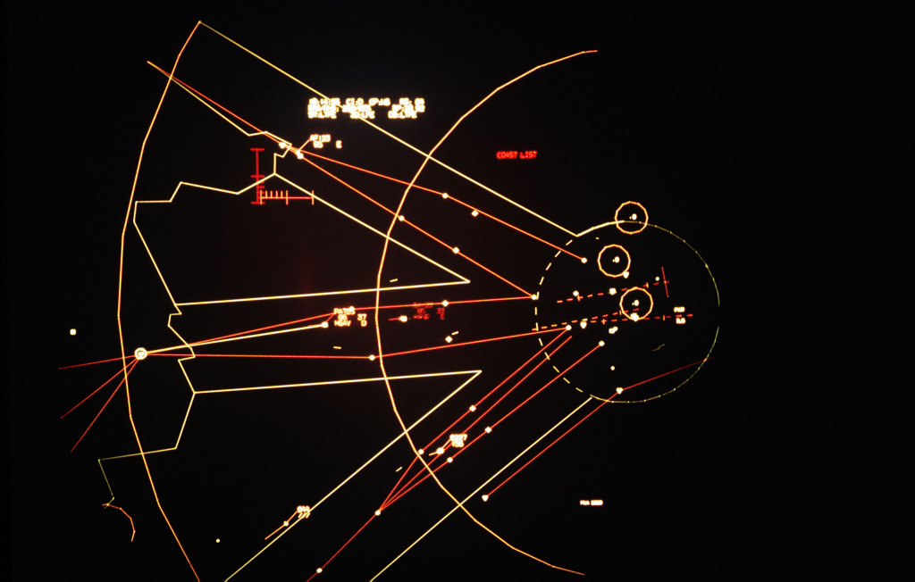
Commented graphic
Graphic with explanations
| Airfields | |
| - Berlin | Berlin: RAF Gatow Airfield, Berlin: Tegel Airport, Tempelhof |
| - East Germany | Berlin: Schönefeld Airport, Brandenburg: Briest Air Base, Mahlwinkel: Air Base, Oranienburg: Air Base, Schönhauser Damm: Airfield, Zerbst: Air Base |
| Radio beacons | |
| - Berlin | HVL=Havel, DLS=Lübars, TGL=Tegel, TOF=Tempelhof |
| - Federal Republic | BKD=Brünkendorf, HLZ=Hehlingen |
| - East Germany | NUF=Nunsdorf, RSF=Reinsdorf |
| Airways | |
| - Corridors | North Route 1, North Route 2, Center Route 1, Center Route 2, South Route 1, South Route 2, Havel Transition |
| - Federal Republic | B 29, B 29 S, B 29 E, G 9, G 9 N, G 9 S |
| - East Germany | B 50 |
| Reporting Points | |
| - Corridors | AKENA, ALANU, ELBEN, GUSEN, KIRIS, KONEN, LIKTI, LINDU, NIDAR, NUVEN, RINOV, ROSLA, VELTE |
| The names of the reporting points are derived from nearby locations. Up to the general switch to 5-letter-names, the full name was used, e.g. KONEN=KONNERN, RINOV=RHINOW, VELTE=VELTEN | |
| Flights | |
| AF123 With northwesterly heading in the North Corridor, short in front of the Brunkendorf beacon. "85" could be the height (Flight level FL85, in the corridors, flight levels ending on 5 were used, probably to be able to use the maximum agreed level FL95). | |
| PA725 | Center Corridor, "86"=Height FL86?, "37"=Ground speed 370 kt?, "HSAV" (?) unknownr, "D" unknown. Die white line to the HLZ beacon is described below. |
| ??? | Target in the Center Corridor, flight ID unreadable on the original picture. |
| 6227 | In the area of the South Corridor, near the reporting point ROSLA, probably an east german or soviet aircraft. If "156" is the altitude FL156, then the target would be well above the maximum agreed altitude for a corridor. "6227" could be the transponder code. The code area "62" was assigned to east germany, but mainly used for international flights that began in east germany; so the westerly heading of this target does not match to it. |
| 044 | This target moves parallel to the corridor in southwestern direction. The length of the line for the projected flight path indicates high speed. |
| Others | |
| Data Block | The data area is not fully readable on the orginal picture. "1.:14:23" looks like the time, "CI:D" unknown, "OP:..." unknown, "RS:..." unknown, "BRG/RNG: ..." direction and distance for the measurement tool, it begins at the target "PA725" and ends at the HLZ beacon, so it should show direction and distance from the target to HLZ. "BP:29.92" looks like "Barometric Pressure Setting" (in inch), maybe to adjust the measured heights from this 3D radar to the barometric measured altitudes; "SR" unknown, "3D" unknown, "DB" unknown |
| COAST LIST | The COAST LIST shows targets which disappeared from the radar. Here it is empty. |
| Stars | In each corridor, in a distance of about 35 NM, there are two stars shown. They are positioned approximately on the flying routes, but in two cases they are quite away (see southwest of Briest airfield). Purpose unknown. |
| Circles | In the area of the Berlin Control Zone, there are three circles visible. They match to the high radio masts of Zehlendorf (east of Oranienburg), Frohnau and TV tower. In the lower left corner of the picture, there is another circle partly visible. It could belong to the Brocken mountain. |
| White dots | In a distance of about 90 NM, north of the southern corridor, there is a white dot shown. It is the area of Quedlinburg. The purpose is unknown. Another white dot can be seen west-northwest of HLZ beacon. Purpose unknown. And there are some dots in the Berlin Control Zone, which are also unclear to me. |
The screens looks empty, probably because no primary radar information is shown. Therefor, only targets with an active transponder are visible.
Please see the picture above for an explanation of the airfields, airways etc. Texts which is unreadable on the original picture is shown as # in the graphic.
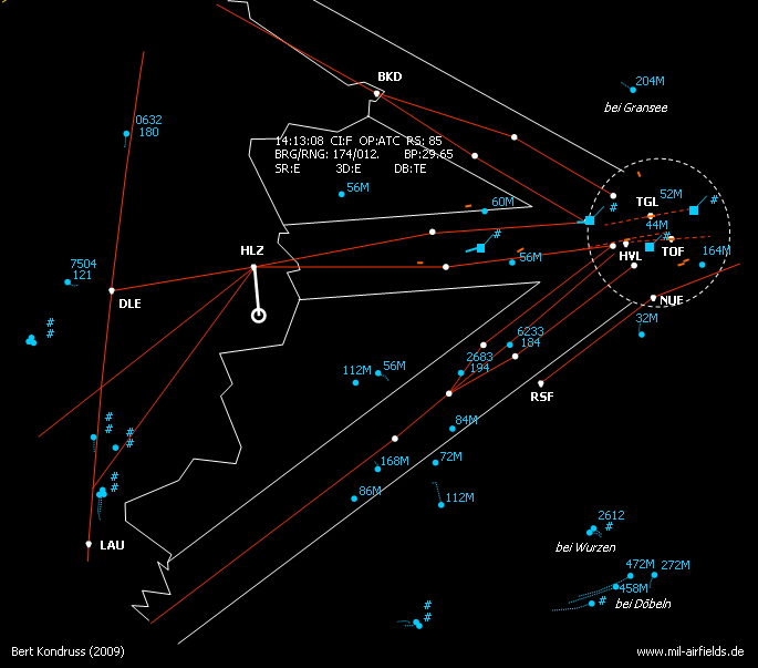
In contrast to the picture above, primary data is shown here. With it, you get a good impression of the flying activities in the southwestern part of former east germany. Clutter is shown in the Berlin area.
The primary targets show their past positions with dots. They also show a figure, ending with "M". This looks like the height of the target, but probably, "M" does not mean "meter". Instead, it could symbolize that the height is measured by the 3D radar (in contrast for being transmitted by the transponder)
To save some efforts when creating the graphic, the past position symbols are not shown dot by dot. Instead, I draw a dotted line along the chain. But it means that the speed-dependend distance between two dots can only be recognized on the photo.
Interesting are the three sequenced primary targets that are on a long left turn in the Dobeln area. On the photo, the past position symbols have great distances, so the targets seems to move at high speed.
The measurement instrument "hangs down" from the HLZ beacon. Accordingly, the textblock shows: BRG/RNG: 174/012.
Polish Aircraft at Tempelhof Airport - Tempelhof, Poland and East Germany
Several times, planes from Poland were hijacked or used to escape. Among others:
- 12JUN1982 Yak-12A SP-ABX Flight from Wroclaw Szymanow to Tempelhof. The aircraft was painted with red stars to confuse the air defense.
- 17SEP1983 An-2 SP-ANK The flight began on the airfield of Przylep, near Zielona Góra. On board were Jan Z. (pilot) and Mieczysław S., who both coordinated the escape. At an intermediate stop on a field near Letnica, 7 more people were picked up, including 4 childrens.
In 2005-2006 Polish TV made series of films - dramatized documentary - under the general title: "Wielkie Ucieczki" (Great Escapes), see http://www.filmpolski.pl/fp/index.php/4221384 (polish). One of the episodes describes in detail the An-2 SP-ANK escape story. The title of this episode is:"Tempelhof - Brama do wolności" (Tempelhof - Gate to freedom).
- 25OCT1983 Yak-12 SP-KLA The aircraft belonged to the Aeroclub Swidnik. The flight to Tempelhof began at the airfield of Leszno.
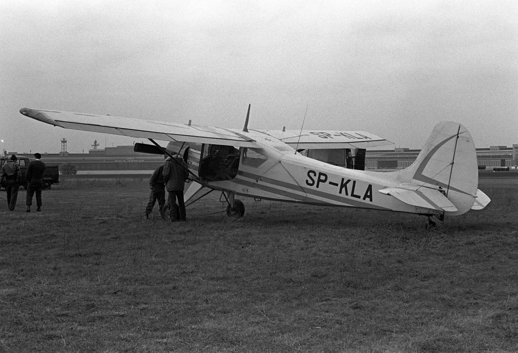
Yak-12 in Tempelhof (October 25th, 1983) (Quelle: DoD, Thomas Farr)
- 15SEP1984 PZL-101 Gawron SP-CGF Flight from Szczecin Dąbie to Tempelhof.
FOUR TIMES THROUGH THE BERLIN WALL TO POLAND
My trips to Berlin to fly aircraft back to Poland
General procedures
Each time I was delegated to Berlin as an employee (among others pilot and flight instructor) of the Aero Club of Poland (all four aircraft were property of the Aero Club of Poland). I have preserved - until now - my personal three DDR passes through the Berlin Wall !!! (Friedrichstrasse - Checkpoint Charlie).
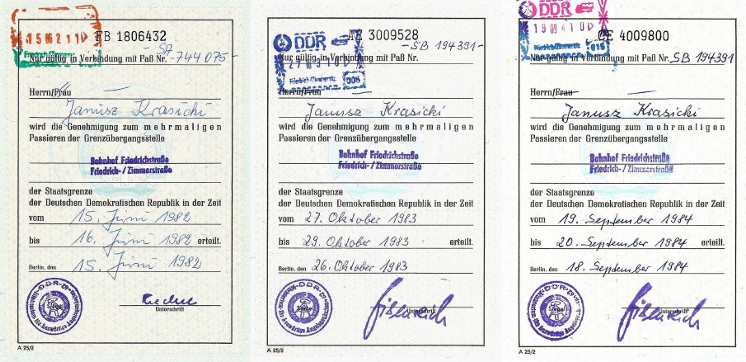
The normal procedure was that each time on arrival in East Berlin (three times Ostbahnhof, one time Berlin: Schönefeld Airport) I had contacted Polish Embassy (Unter den Linden) or I had been met by gentlemen from LOT Polish Airlines in East or West Berlin, then I was conveyed through the Berlin Wall (Friedrichstrasse) to the Polish Military Mission in West Berlin (Grunewald, Lassenstrasse 19-21; now the Polish Embassy HQ). The Mission was responsible for all further arrangements with American authorities at Tempelhof and gentlemen from the Mission were quite experienced owing to previous Polish landings at this airport.
My four flights
The normal route was, in principle: Tempelhof – Drewitz/Dreilinden (= Checkpoint Bravo) - VOR NUF (Nunsdorf) - NDB BKW (Beeskow) - SUI (Slubice) - .... But in practice each time the route was slightly different.
1) 16.06.1982: Jak-12A SP-ABX It appeared that there is no petrol at Tempelhof as only jet fuel was available (only turbine-engined aircraft were operating from Tempelhof) and there was not enough fuel in the plane’s tanks for the flight to Poland. So it was decided that I must make a short flight to Schönhagen for refuelling. (I had occasion to visit this big GST (Gesellschaft für Sport und Technik) centre a year before when I was a member of the Polish team that attended the World Gliding Championships in Paderborn in 1981; and on return route from Paderborn - with 4 gliders on trailers - we stayed overnight in Schönhagen.).
Now my departure from Tempelhof was delayed, as earlier that day I had to pay a visit to GST HQ (and DDR Aeroklub) in East Berlin to discuss details of the flight and refuelling. So I reached Schönhagen only in the evening and I spent the night here, to continue my flight the next day, June 17, via Beeskow - Slubice - to Zielona Góra (Przylep Airfield) = the place of An-2 hijacking in 1983. Here there was passport control and a long interrogation by a special officer; and only after that I followed to Wroclaw / Szymanow, where the plane was from.
2) 20.09.1983: An-2 SP-ANK This time it appeared the day before (September 19) that there is not enough engine oil in the plane’s oil tank. So oil (Soviet oil MS-20, widely used in the East in engines of Soviet origin) was specially transported to Tempelhof from Schönefeld in the morning on September 20th.
As concerns fuel: this time petrol was available at Tempelhof and we took 300 litres. (There were only about 100 litres in the fuel tanks. On September 17, when An-2 departed from Zielona Góra, the left fuel level warning lamp lighted up - as reported later by the pilot, Jan Z. - just after take off, the right one after crossing the DDR border; the lamps light up indicating about 80 litres in left or right tanks).
The flight route was – this time – exactly as laid down in official rules: Tempelhof – Drewitz/Dreilinden - VOR NUF (Nunsdorf) – BKW (Beeskow) - SUI (Slubice). The An-2 was not fitted with VOR (like other Polish Aero Club’s aircraft in those years), but I had identified the VOR on the ground (map and coordinates). Destination - in the Flight Plan - was Zielona Góra / Przylep, but after crossing the DDR/Polish border the weather dramatically deteriorated and we had been directed to Poznan / Lawica.
An-2 SP-ANK: Engine check prior to departure for Poland. Crew: Janusz Krasicki (Pilot), Józef S. (flight engineer) 20.09.1983 (Source: DoD, Thomas Farr)
3) 27.10.1983: Jak-12A SP-KLA and 4) 19.09.1984: PZL-101 SP-CGF The route was slightly amended in that it was not necessary now to overfly Drewitz/Dreilinden road border crossing, so I flew: Tempelhof - NUF - BKW - SUI - EPPO (Poznan Lawica). As the Jak-12A SP-KLA was from the Aero Club in Swidnik (near Lublin), I spent the night 27/28 October in Poznan and on 28 October I continued to Warsaw Babice. With PZL-101 SP-CGF in 1984, I finished in Poznan.
To avoid possible problems with MS-20 oil, on both last trips to Berlin I brought a 3-litre plastic container with MS-20; (I used it for Jak-12A; PZL-101 was OK). But another device that appeared indispensable (I was, providently, equipped with) was an adapter (connection terminal) for compressed air; American air piping terminals did not fit Russian inlets (compressed air is used in these aircraft for starting engine and for operating flaps and wheel brakes; in many aircraft the compressed air installation is not tight and bottles must be refilled from an external source).
Air Traffic Control
I had been in radio contact with both US controllers on Tempelhof and with East German air traffic control, though in two cases this communication was not easy to establish and maintain: two of four aeroplanes were fitted with quite obsolete equipment (4-channel transceivers R-800), so there were air traffic controllers that were kind enough to tune to one of my only four frequencies !!!).
Janusz Krasicki
Contents
Page 1: From the beginnings until 1945
Page 3: Tempelhof Airport: The 1950s
Page 4: Berlin Tempelhof Central Airport from 1960 to 1993 ← you are here
 Follow mil-airfields on Facebook