For historical information only, do not use for navigation or aviation purposes!
| Coordinates | N505914 E0065328 (WGS84) Google Maps |
| Elevation | 158 ft |
| Federal state | Nordrhein-Westfalen (North Rhine-Westphalia) |
| Location indicator | DABZ (195x), EDUZ (RAF), EDCU (-199x) |
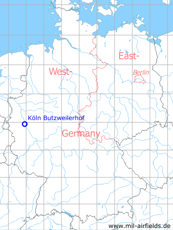
Germany during the Cold War Map
The history of the Cold War airfields: Köln
Contents
General
The airfield Cologne-Butzweilerhof was opened before the First World War and militarily used until the end of the war. This was followed by an occupancy by the Royal Air Force (RAF) until the 1920s, when the airport of Cologne started operating here. After the end of the Second World War, the field was again occupied by the RAF, which was followed by Belgian army aviation in 1957. At the same time a sports airfield was opened at the Butzweilerhof, which was closed again in 1980. In 1995 the Belgian airmen withdrew and the airfield was finally closed.
Location of airfield
7 km northwest of Cologne city center
During the 1920s/1930s
Overview
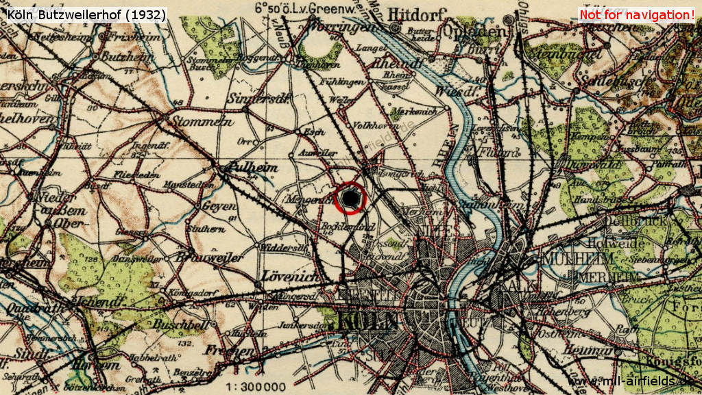
Map of Köln (Cologne) and vicinity in 1932
Köln (Cologne) Butzweilerhof airfield in 1932
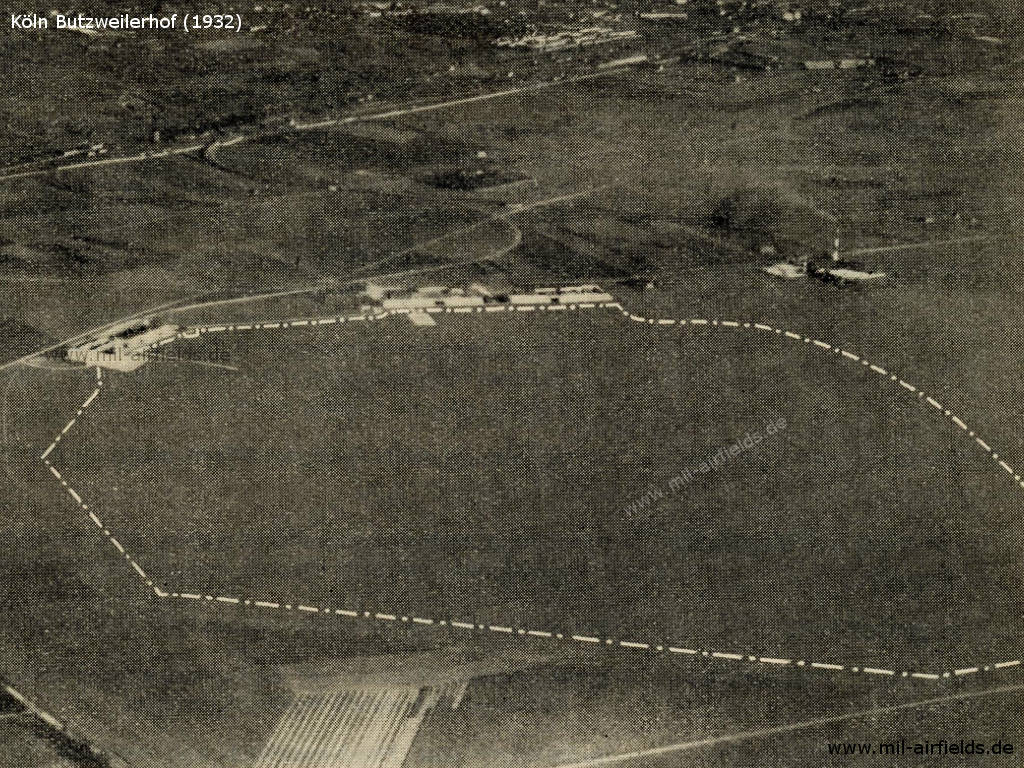
Köln (Cologne) Butzweilerhof airport: Aerial picture 1932
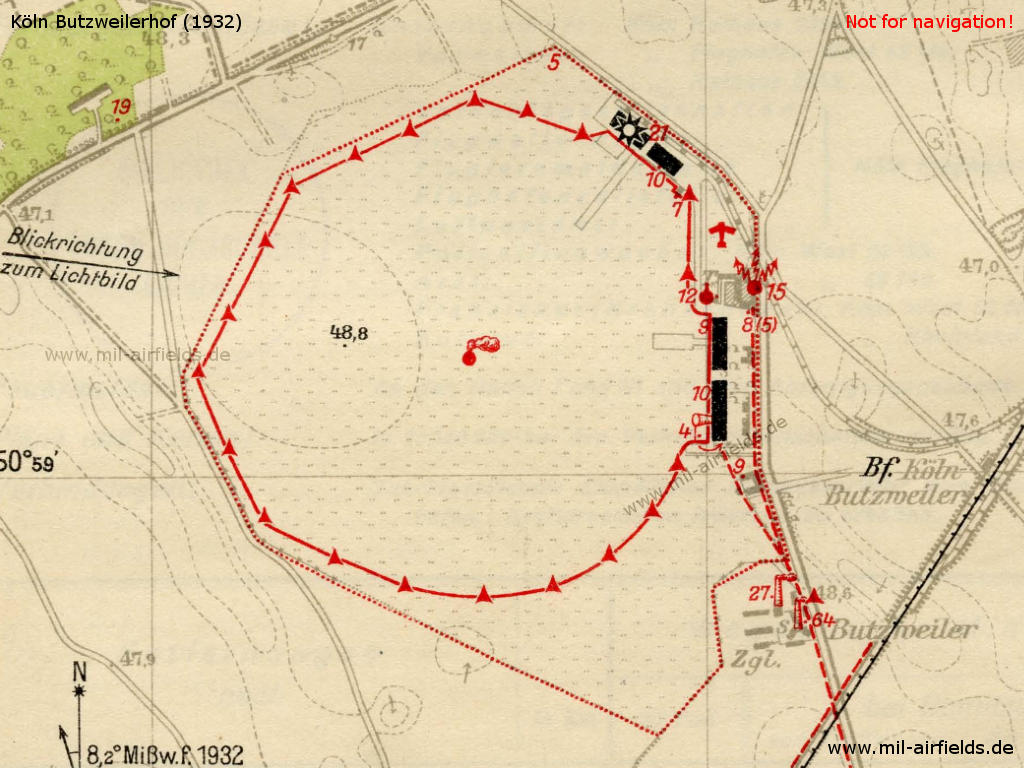
Airfield characteristics at daytime
Das Rollfeld des Flughafens liegt etwa 5 km westlich des Rheins unmittelbar westlich der Kölner Umgehungsbahn und südlich der Bahnlinie Köln-Neuß. An der Südostecke 2 rot-weiß gestrichene Schornsteine. Auf den Hallendächern die weiße Aufschrift "Köln". Landezeichen in Kreisform liegt ständig aus. Rauchofen. Windrichtungsanzeiger in Flugzeugform. Windsack auf der südlichen Flugzeughalle. Ausgeflaggte Antennen über den Verwaltungsbaracke, Flagge auf der R-Halle, Rollfeldgrenzen durch rot-weiße Böcke bezeichnet.
Airfield characteristics at night
Keine ständige Nachtbefeuerung. Auf Anforderung beim Verwalter rotes Blinkfeuer auf 12 m hohem Gerüst. Höhe des Feuers über NN 60 m, über dem Erdboden: 12 m - Blinkfeuer mit Einzelblink, rot
Kennung: Blink 1 s
Pause 6,2 s
Wiederkehr 7,2 s
148 000 HK, mittl. Tragweite 20 km. Bemerkung: Das Feuer ist bewacht. Auf Anforderung ferner Randfeuer und Befeuerung der oberen Dachkanten der Flugzeughallen. Landefeuer aus grünen, weißen und roten Feuern in Windrichtung. Es ist von grün über weiß auf rot hin, rechts der Reihe zu landen. Der Windrichtungsanzeiger in Flugzeugform ist beleuchtet. Die 15 m hohen Antennenmastspitzen und 25 bzw. 55 m hohen Schornsteine im Osten des Rollfeldes werden rot befeuert.
Runways
Gelände: Gute Grasnarbe auf sandigem Lehmboden, keine Sumpfbildung.
Kleinste Rollänge: In allen Richtungen 1000 m.
Radio communication
Rufzeichen: ddK, Flugbodenfunk- und Peilstelle für Nachrichten und Peilverkehr mit Flugzeugen. Anrufwelle 323 kHz (930 m). Flugfunk- und Kabelstelle.
Hangars
4 Flugzeughallen, davon: Halle II als Abfertigungsgebäude ausgebaut.
- Halle I: Länge: 124,0 m, Breite 20,0 m, Höhe 6,0 m, Torweite: 20,0 m, Torhöhe 4,9 m
- Halle III: Länge: 76,0 m, Breite 25,0 m, Höhe 8,8 m, Torweite: 25,0 m, Torhöhe 5,5 m
- R-Halle: Länge: 50,0 m, Breite 30,0 m, Höhe 15,5 m, Torweite: 50,0 m, Torhöhe 10,0 m
Die Hallen haben Betonboden, die R-Halle enthält einen Kettenflaschenzug von 1,0 Tragfähigkeit.
Workshops
Die Anbauten der R-Halle enthalten alle zur Instandsetzung von Holz- und Metallflugzeugen erforderlichen Einrichtungen. Autogene Schweißanlage, Akku-Ladestation. Elektrischer Strom: Drehstrom 220/380 V. Ersatzteile für fast alle Verkehrsflugzeugmuster vorrätig.
Fuel equipment
3 Tankanlagen:
- 1: 50000 l Einheitsbetriebsstoff der Deutschen Luft Hansa
- 2: 25.000 l Shell-Benzin
- 3: je 3000 l Benzin und Benzol.
- 1: 50000 l Einheitsbetriebsstoff der Deutschen Luft Hansa
- 2: 25.000 l Shell-Benzin
- 3: je 3000 l Benzin und Benzol.
Druck-Mischeinrichtungen. 2 Tankwagen für je 1000 l vorhanden. Anlagen für Schmierstoffe. Betriebs- und Schmierstoffe in beliebiger Menge ständig vorrätig.
Railway siding
Mit Stirn- und Seitenrampe vorhanden.
First aid in the case of accidents
Wird durch Polizeiflugwache versehen, Sanitätsraum mit Einrichtung vorhanden. Nächster Arzt in Longerich (1,5 km Entfernung).
Customs, post office, passport
Zollflughafen, Postamt mit Fernsprecher und Telegraph vorhanden. Paß-Kontrolle durch Polizeiflugwache.
Accommodation of passengers
Ruheräume im Abfertigungsgebäude, sonst in der Stadt.
Connections
Zubringerdienst: Stündlicher Autobusverkehr vom Dom zum Flughafen. Kraftdroschken jederzeit zu erhalten.
Timetable
Spring/Summer 1939
The timetable for spring/summer of 1939 shows the following scheduled flights:
(Days: 1=Monday ... 7=Sunday)
(Days: 1=Monday ... 7=Sunday)
6: Berlin (Tempelhof) - Cologne (Butzweilerhof) - Paris (Le Bourget)
- Deutsche Lufthansa, Junkers Ju 52 / Air France, Dewoitine 338:
123456– | Berlin 17:30 - 19:35 Cologne 20:00 - 21:50 Paris - Deutsche Lufthansa, Junkers Ju 52 / Air France, Dewoitine 338:
123456– | Paris 08:30 - 10:10 Cologne 10:35 - 12:35 Berlin
24: Berlin (Tempelhof) - Dortmund (Brackel) - Cologne (Butzweilerhof)
- Deutsche Lufthansa, Junkers Ju 52:
123456– | Berlin 19:30 - 21:40 Dortmund 21:50 - 22:20 Cologne - Deutsche Lufthansa, Junkers Ju 52:
123456– | Cologne 07:20 - 07:45 Dortmund 07:55 - 09:45 Berlin
28: Hamburg (Fuhlsbüttel) - Bremen (Neuenland) - Essen/Mühlheim - Cologne (Butzweilerhof) - Saarbrücken (St. Arnual)
- Deutsche Lufthansa, Junkers Ju 86:
123456– | Hamburg 15:55 - 16:25 Bremen 16:35 - 17:30 Essen/Mühlheim 17:40 - 18:00 Cologne 18:15 - 19:10 Saarbrücken - Deutsche Lufthansa, Junkers Ju 86:
123456– | Saarbrücken 06:15 - 07:10 Cologne 07:25 - 07:45 Essen/Mühlheim 07:55 - 08:50 Bremen 09:00 - 09:30 Hamburg
30: Amsterdam (Schiphol) - Rotterdam (Waalhaven) - Cologne (Butzweilerhof) - Frankfurt (Rhein/Main) - Milan (Linate) - Rome (Littorio/Urbe)
- Deutsche Lufthansa, Junkers Ju 52 / KLM, Douglas DC 2 / ALI (Avio Linee Italiane, Milano), Fiat:
1234567 | Amsterdam 09:30* - 09:50* Rotterdam 10:00* - 10:35 Cologne 11:00 - 11:50 Frankfurt/M 12:10 - 14:40 Milan 16:00 - 18:00 Rome
*1 hour earlier from 16 April to 14 May - Deutsche Lufthansa, Junkers Ju 52 / KLM, Douglas DC 2 / ALI (Avio Linee Italiane, Milano), Fiat:
1234567 | Rome 07:00 - 09:00 Milan 09:30 - 12:00 Frankfurt/M 12:20 - 13:10 Cologne 13:25 - 14:40* Rotterdam 14:50* - 15:10* Amsterdam
*1 hour earlier from 16 April to 14 May
36: Cologne (Butzweilerhof) - Frankfurt (Rhein/Main) - Mannheim (Neuostheim) - Karlsruhe - Freiburg
- Deutsche Lufthansa, Junkers Ju 52:
123456– | Cologne 10:30 - 11:20 Frankfurt/M 12:15 - 12:40 Mannheim 12:50 - 13:10 Karlsruhe 13:20 - 14:00 Freiburg - Deutsche Lufthansa, Junkers Ju 52:
123456– | Freiburg 16:45 - 17:25 Karlsruhe 17:35 - 17:55 Mannheim 18:05 - 18:30 Frankfurt/M 18:50 - 19:40 Cologne
45: Essen/Mühlheim - Cologne (Butzweilerhof) - Frankfurt (Rhein/Main) - Nuremberg (Marienberg) - Munich (Oberwiesenfeld)
- Deutsche Lufthansa, Junkers Ju 52:
123456– | Essen/Mühlheim 17:10 - 17:30 Cologne 17:45 - 18:35 Frankfurt/M 18:45 - 19:45 Nuremberg 20:00 - 20:50 Munich - Deutsche Lufthansa, Junkers Ju 52:
123456– | Essen/Mühlheim - Cologne - Frankfurt/M - Nuremberg - Munich - Deutsche Lufthansa, Junkers Ju 52:
123456– | Munich 08:05 - 08:55 Nuremberg 09:05 - 10:15 Frankfurt/M 10:30 - 11:20 Cologne 11:30 - 11:50 Essen/Mühlheim
155: Halle/Leipzig (Schkeuditz) - Cologne (Butzweilerhof)
- Deutsche Lufthansa, Junkers Ju 52:
123456– | Halle/Leipzig 08:00 - 09:55 Cologne - Deutsche Lufthansa, Junkers Ju 52:
123456– | Cologne 20:15 - 21:55 Halle/Leipzig
156: Dresden (Klotzsche) - Halle/Leipzig (Schkeuditz) - Dortmund (Brackel) - Cologne (Butzweilerhof) - Düsseldorf (Lohausen)
- Deutsche Lufthansa, Junkers Ju 86:
123456– | Dresden 16:30 - 17:10 Halle/Leipzig 17:20 - 19:05 Dortmund 19:15 - 19:45 Cologne 20:05 - 20:20 Düsseldorf - Deutsche Lufthansa, Junkers Ju 86:
123456– | Düsseldorf 10:25 - 10:40 Cologne 10:50 - 11:20 Dortmund 11:30 - 13:00 Halle/Leipzig 13:10 - 13:45 Dresden
1001: London (Croydon) - Brussels (Haren) - Cologne (Butzweilerhof)
- Sabena, Savoia Marchetti S 73:
123456– | London 17:15 - 18:40 Brussels 18:55 - 19:55 Cologne - Sabena, Savoia Marchetti S 73:
123456– | Cologne 10:15 - 11:15 Brussels 11:30 - 13:00 London
1005: London (Croydon) - Brussels (Haren) - Cologne (Butzweilerhof)
- Sabena, Savoia Marchetti S 73:
1234567 | London 13:30 - 14:55 Brussels 15:10 - 16:10 Cologne - Sabena, Savoia Marchetti S 73:
1234567 | Cologne 17:10 - 18:10 Brussels 18:30 - 20:00 London
F170: Berlin (Tempelhof) - Halle/Leipzig (Schkeuditz) - Cologne (Butzweilerhof) - Amsterdam (Schiphol)
- Deutsche Lufthansa, Junkers Ju 52:
1234567 | Berlin 23:20 - 00:10 Halle/Leipzig 00:25 - 02:25 Cologne 07:40 - 09:00 Amsterdam
Mail and freight only; not from Sundays to Mondays - Deutsche Lufthansa, Junkers Ju 52:
123456– | Amsterdam 12:30 - 13:45 Cologne 13:55 - 15:05 Berlin
Mail and freight only
PF171: Berlin (Tempelhof) - Hannover (Vahrenwald) - Cologne (Butzweilerhof) - London (Croydon)
- Deutsche Lufthansa, Junkers Ju 52 / British Airways, Junkers Ju 52:
1234567 | Berlin 23:35 - 00:55 Hannover 01:20 - 02:40 Cologne 03:05 - 05:35 London
Air mail service and limited freight transport; not from Sundays to Mondays - Deutsche Lufthansa, Junkers Ju 52 / British Airways, Junkers Ju 52:
1234567 | London 22:00 - 00:30 Cologne 00:55 - 02:10 Hannover 02:40 - 03:50 Berlin
Air mail service and limited freight transport; not from Sundays to Mondays
PF172: Cologne (Butzweilerhof) - Paris (Le Bourget)
- Deutsche Lufthansa, Junkers Ju 52:
–234567 | Cologne 03:10 - 05:15 Paris
Air mail and freight transport only; not from Sundays to Mondays - Deutsche Lufthansa, Junkers Ju 52:
1234567 | Paris 22:20 - 00:15 Cologne
Air mail and freight transport only; not from Sundays to Mondays
PF173: Cologne (Butzweilerhof) - Frankfurt (Rhein/Main) - Nuremberg (Marienberg) - Munich (Oberwiesenfeld)
- Deutsche Lufthansa, Junkers Ju 52:
–234567 | Cologne 01:20 - 02:10 Frankfurt/M 03:15 - 04:15 Nuremberg 04:30 - 05:20 Munich
Air mail and freight transport only; not from Sundays to Mondays - Deutsche Lufthansa, Junkers Ju 52:
1234567 | Munich 22:25 - 23:15 Nuremberg 23:30 - 00:30 Frankfurt/M 01:30 - 02:20 Cologne
Air mail and freight transport only; not from Sundays to Mondays
PF178: Cologne (Butzweilerhof) - Cherbourg
- Deutsche Lufthansa, Focke-Wulf Fw 58:
Cologne 11:00 - 13:40 Cherbourg
Air mail service only; from Cologne to the departure of the ocean liner: 19 April 1939 "Europa", 29 April 1939 "Bremen", 06 May 1939 "Europa", 20 May 1939 "Bremen", 29 May 1939 "Europa", 07 June 1939 "Bremen" - Deutsche Lufthansa, Focke-Wulf Fw 58:
Cherbourg ##:## - ##:## Cologne
Air mail service only; departure from Cherbourg after the arrival of the steam ships: 20 April 1939 "Bremen", 01 May 1939 "Europa", 01 June 1939 "Bremen", 08 June 1939 "Europa"
PF181: Berlin (Tempelhof) - Dortmund (Brackel) - Cologne (Butzweilerhof)
- Deutsche Lufthansa, Junkers Ju 52:
–234567 | Berlin 01:50 - 04:00 Dortmund 04:15 - 04:45 Cologne
Air mail and freight transport only; not from Sundays to Mondays - Deutsche Lufthansa, Junkers Ju 52:
–234567 | Cologne 00:50 - 01:20 Dortmund 01:40 - 03:40 Berlin
Air mail and freight transport only; not from Sundays to Mondays
PF888: Amsterdam (Schiphol) - Rotterdam - Cologne (Butzweilerhof)
- KLM, DC-2:
1234567 | Amsterdam 23:20 * - 23:40 * Rotterdam 23:50 * - 00:25 Cologne
Air mail and freight transport, limited passenger service; not from Saturdays to Sundays and Sundays to Mondays;
*1 hour earlier from 16 April to 14 May 1939 - KLM, DC-2:
1234567 | Cologne 03:15 - 04:35 * Rotterdam 04:45 * - 05:05 * Amsterdam
Air mail and freight transport, limited passenger service; not from Saturdays to Sundays and Sundays to Mondays;
*1 hour earlier from 16 April to 14 May 1939
PF1071: Brussels (Haren) - Cologne (Butzweilerhof)
- Sabena, Junkers Ju 52:
123456– | Brussels 23:00 - 23:50 Cologne
Air mail and freight transport only; not from Sundays to Mondays - Sabena, Junkers Ju 52:
123456– | Cologne 03:20 - 04:15 Brussels
Air mail and freight transport only; not from Sundays to Mondays
Departures and arrivals by time
| Days | Time | Dep/Arr | Route | Operator | Aircraft type | to/from |
|---|---|---|---|---|---|---|
| ##:## | Arr | PF178 | Deutsche Lufthansa | Focke-Wulf Fw 58 | Cherbourg | |
| 1234567 | 00:15 | Arr | PF172 | Deutsche Lufthansa | Junkers Ju 52 | Paris |
| 1234567 | 00:25 | Arr | PF888 | KLM | DC-2 | Amsterdam - Rotterdam |
| 1234567 | 00:30 | Arr | PF171 | Deutsche Lufthansa / British Airways | Junkers Ju 52 / Junkers Ju 52 | London |
| –234567 | 00:50 | Dep | PF181 | Deutsche Lufthansa | Junkers Ju 52 | Dortmund - Berlin |
| 1234567 | 00:55 | Dep | PF171 | Deutsche Lufthansa / British Airways | Junkers Ju 52 / Junkers Ju 52 | Hannover - Berlin |
| –234567 | 01:20 | Dep | PF173 | Deutsche Lufthansa | Junkers Ju 52 | Frankfurt/M - Nuremberg - Munich |
| 1234567 | 02:20 | Arr | PF173 | Deutsche Lufthansa | Junkers Ju 52 | Munich - Nuremberg - Frankfurt/M |
| 1234567 | 02:25 | Arr | F170 | Deutsche Lufthansa | Junkers Ju 52 | Berlin - Halle/Leipzig |
| 1234567 | 02:40 | Arr | PF171 | Deutsche Lufthansa / British Airways | Junkers Ju 52 / Junkers Ju 52 | Berlin - Hannover |
| 1234567 | 03:05 | Dep | PF171 | Deutsche Lufthansa / British Airways | Junkers Ju 52 / Junkers Ju 52 | London |
| –234567 | 03:10 | Dep | PF172 | Deutsche Lufthansa | Junkers Ju 52 | Paris |
| 1234567 | 03:15 | Dep | PF888 | KLM | DC-2 | Rotterdam - Amsterdam |
| 123456– | 03:20 | Dep | PF1071 | Sabena | Junkers Ju 52 | Brussels |
| –234567 | 04:45 | Arr | PF181 | Deutsche Lufthansa | Junkers Ju 52 | Berlin - Dortmund |
| 123456– | 07:10 | Arr | 28 | Deutsche Lufthansa | Junkers Ju 86 | Saarbrücken |
| 123456– | 07:20 | Dep | 24 | Deutsche Lufthansa | Junkers Ju 52 | Dortmund - Berlin |
| 123456– | 07:25 | Dep | 28 | Deutsche Lufthansa | Junkers Ju 86 | Essen/Mühlheim - Bremen - Hamburg |
| 1234567 | 07:40 | Dep | F170 | Deutsche Lufthansa | Junkers Ju 52 | Amsterdam |
| 123456– | 09:55 | Arr | 155 | Deutsche Lufthansa | Junkers Ju 52 | Halle/Leipzig |
| 123456– | 10:10 | Arr | 6 | Deutsche Lufthansa / Air France | Junkers Ju 52 / Dewoitine 338 | Paris |
| 123456– | 10:15 | Dep | 1001 | Sabena | Savoia Marchetti S 73 | Brussels - London |
| 123456– | 10:30 | Dep | 36 | Deutsche Lufthansa | Junkers Ju 52 | Frankfurt/M - Mannheim - Karlsruhe - Freiburg |
| 1234567 | 10:35 | Arr | 30 | Deutsche Lufthansa / KLM / ALI (Avio Linee Italiane, Milano) | Junkers Ju 52 / Douglas DC 2 / Fiat | Amsterdam - Rotterdam |
| 123456– | 10:35 | Dep | 6 | Deutsche Lufthansa / Air France | Junkers Ju 52 / Dewoitine 338 | Berlin |
| 123456– | 10:40 | Arr | 156 | Deutsche Lufthansa | Junkers Ju 86 | Düsseldorf |
| 123456– | 10:50 | Dep | 156 | Deutsche Lufthansa | Junkers Ju 86 | Dortmund - Halle/Leipzig - Dresden |
| 1234567 | 11:00 | Dep | 30 | Deutsche Lufthansa / KLM / ALI (Avio Linee Italiane, Milano) | Junkers Ju 52 / Douglas DC 2 / Fiat | Frankfurt/M - Milan - Rome |
| 11:00 | Dep | PF178 | Deutsche Lufthansa | Focke-Wulf Fw 58 | Cherbourg | |
| 123456– | 11:20 | Arr | 45 | Deutsche Lufthansa | Junkers Ju 52 | Munich - Nuremberg - Frankfurt/M |
| 123456– | 11:30 | Dep | 45 | Deutsche Lufthansa | Junkers Ju 52 | Essen/Mühlheim |
| 1234567 | 13:10 | Arr | 30 | Deutsche Lufthansa / KLM / ALI (Avio Linee Italiane, Milano) | Junkers Ju 52 / Douglas DC 2 / Fiat | Rome - Milan - Frankfurt/M |
| 1234567 | 13:25 | Dep | 30 | Deutsche Lufthansa / KLM / ALI (Avio Linee Italiane, Milano) | Junkers Ju 52 / Douglas DC 2 / Fiat | Rotterdam - Amsterdam |
| 123456– | 13:45 | Arr | F170 | Deutsche Lufthansa | Junkers Ju 52 | Amsterdam |
| 123456– | 13:55 | Dep | F170 | Deutsche Lufthansa | Junkers Ju 52 | Berlin |
| 1234567 | 16:10 | Arr | 1005 | Sabena | Savoia Marchetti S 73 | London - Brussels |
| 1234567 | 17:10 | Dep | 1005 | Sabena | Savoia Marchetti S 73 | Brussels - London |
| 123456– | 17:30 | Arr | 45 | Deutsche Lufthansa | Junkers Ju 52 | Essen/Mühlheim |
| 123456– | 17:45 | Dep | 45 | Deutsche Lufthansa | Junkers Ju 52 | Frankfurt/M - Nuremberg - Munich |
| 123456– | 18:00 | Arr | 28 | Deutsche Lufthansa | Junkers Ju 86 | Hamburg - Bremen - Essen/Mühlheim |
| 123456– | 18:15 | Dep | 28 | Deutsche Lufthansa | Junkers Ju 86 | Saarbrücken |
| 123456– | 19:35 | Arr | 6 | Deutsche Lufthansa / Air France | Junkers Ju 52 / Dewoitine 338 | Berlin |
| 123456– | 19:40 | Arr | 36 | Deutsche Lufthansa | Junkers Ju 52 | Freiburg - Karlsruhe - Mannheim - Frankfurt/M |
| 123456– | 19:45 | Arr | 156 | Deutsche Lufthansa | Junkers Ju 86 | Dresden - Halle/Leipzig - Dortmund |
| 123456– | 19:55 | Arr | 1001 | Sabena | Savoia Marchetti S 73 | London - Brussels |
| 123456– | 20:00 | Dep | 6 | Deutsche Lufthansa / Air France | Junkers Ju 52 / Dewoitine 338 | Paris |
| 123456– | 20:05 | Dep | 156 | Deutsche Lufthansa | Junkers Ju 86 | Düsseldorf |
| 123456– | 20:15 | Dep | 155 | Deutsche Lufthansa | Junkers Ju 52 | Halle/Leipzig |
| 123456– | 22:20 | Arr | 24 | Deutsche Lufthansa | Junkers Ju 52 | Berlin - Dortmund |
| 123456– | 23:50 | Arr | PF1071 | Sabena | Junkers Ju 52 | Brussels |
Images
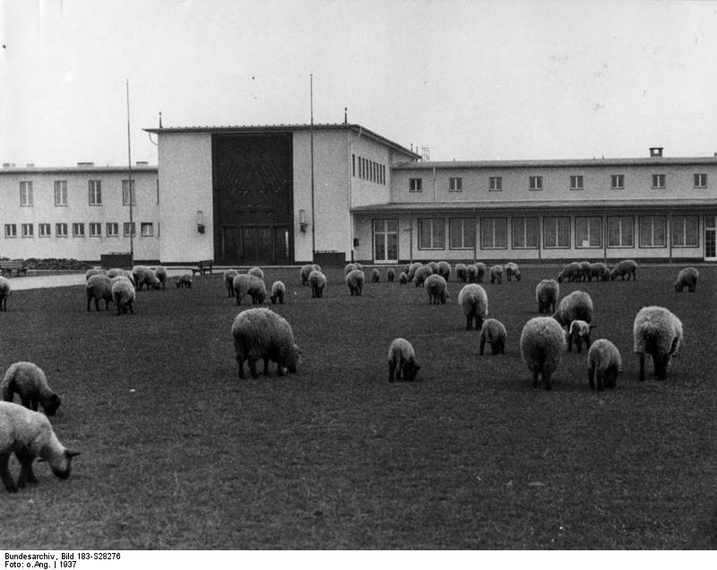
Main entrance to the airport in 1937 - (Bundesarchiv, Bild 183-S28276 / CC-BY-SA 3.0, via Wikimedia Commons)
During World War II
Use
Cologne airport.
Situation
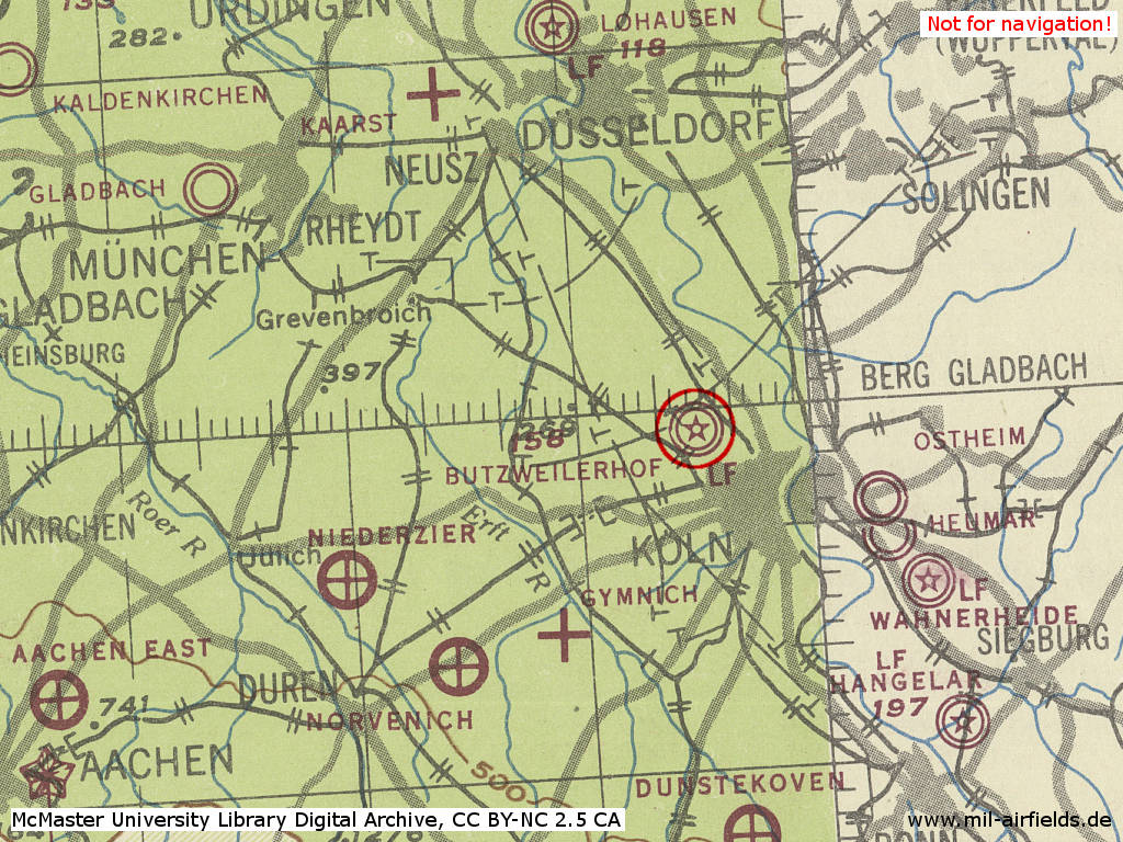
Köln Butzweilerhof Airport in World War II on a US map from 1943 - (McMaster University Library Digital Archive, License: Creative Commons Attribution-NonCommercial 2.5 CC BY-NC 2.5 CA /MULDA/)
Overview
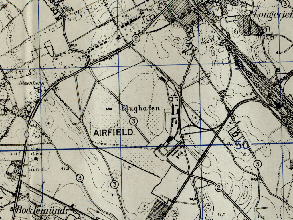
Former Cologne Butzweilerhof airport on a US map from 1951
During the Cold War
Use
Used by RAF until 1953. Used by Belgian Army until 1993 or 1994 (16th Sq / 16th Bat, Alouette II and Britten-Norman Islander).
In the 1960s
Overview
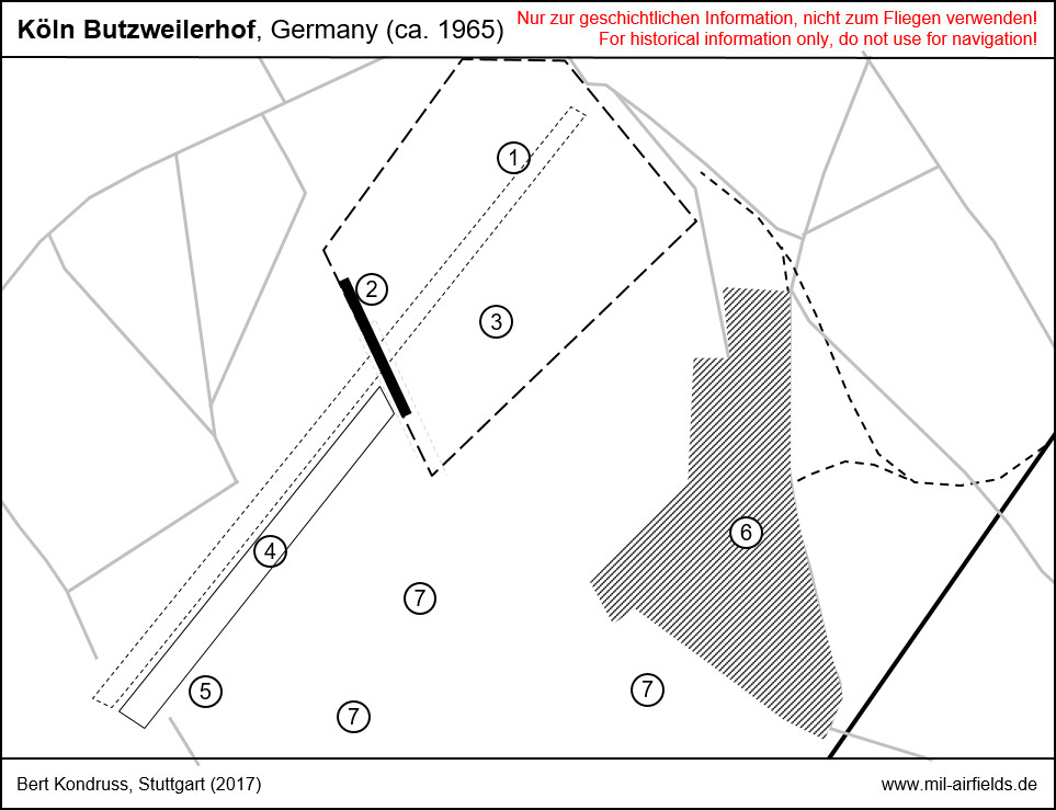
Köln Butzweilerhof airfield in the mid 1960s
| 1 | Old runway, closed |
| 2 | Runway of the military airfield |
| 3 | Military airfield |
| 4 | Runway of the sports airfield |
| 5 | Buildings sports airfield |
| 6 | Barracks |
| 7 | Aerials |
In the 1970s
Overview
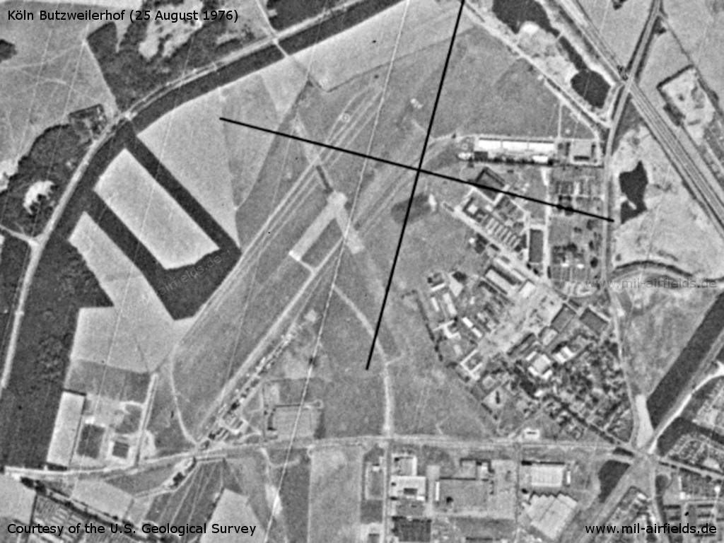
Cologne Butzweilerhof Airfield on a US satellite image from 25 August 1976
Source: U.S. Geological Survey
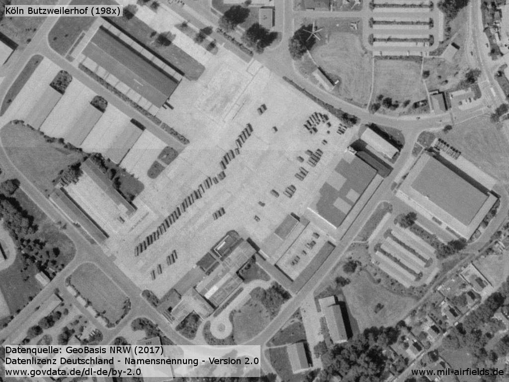
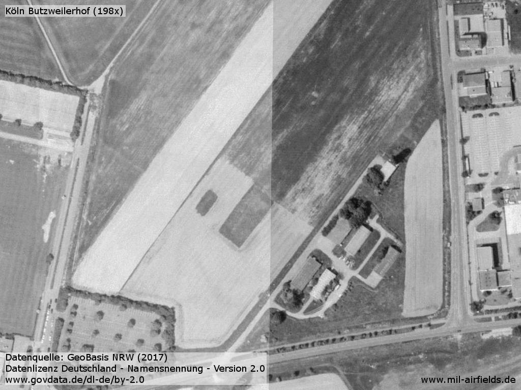
In the 1980s and early 1990s
Overview
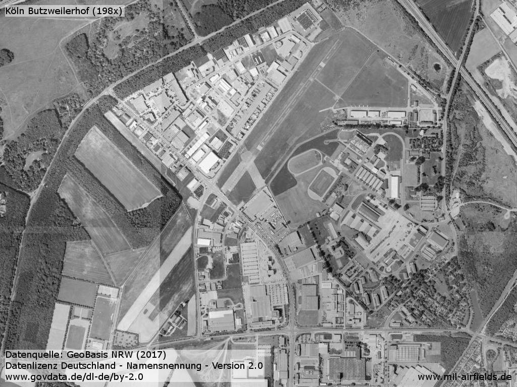
Aerial image late 1980s / early 1990s
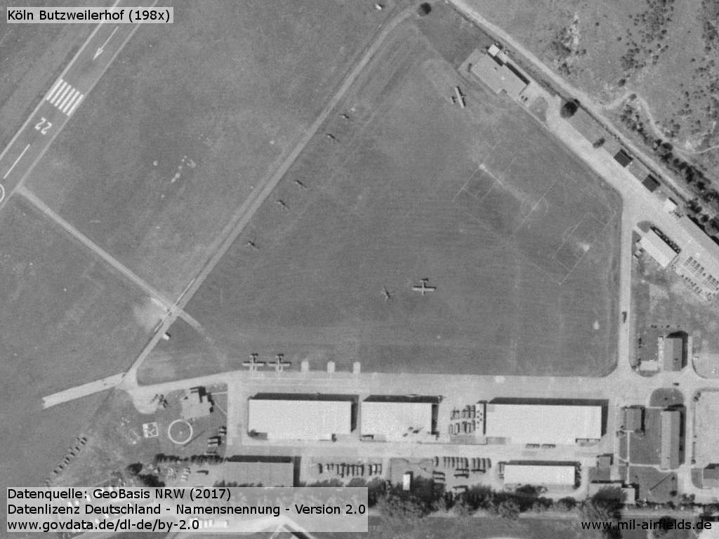
Belgian Army Aviation airfield
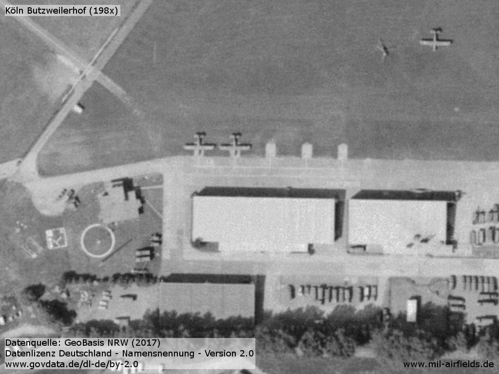
Aircraft Britten Norman Islander and helicopter at Butzweilerhof
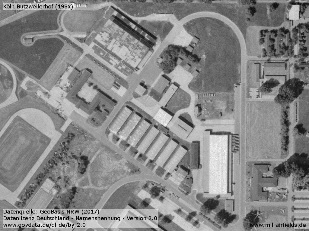
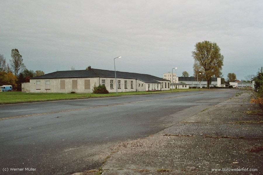
Barracks
Old airport
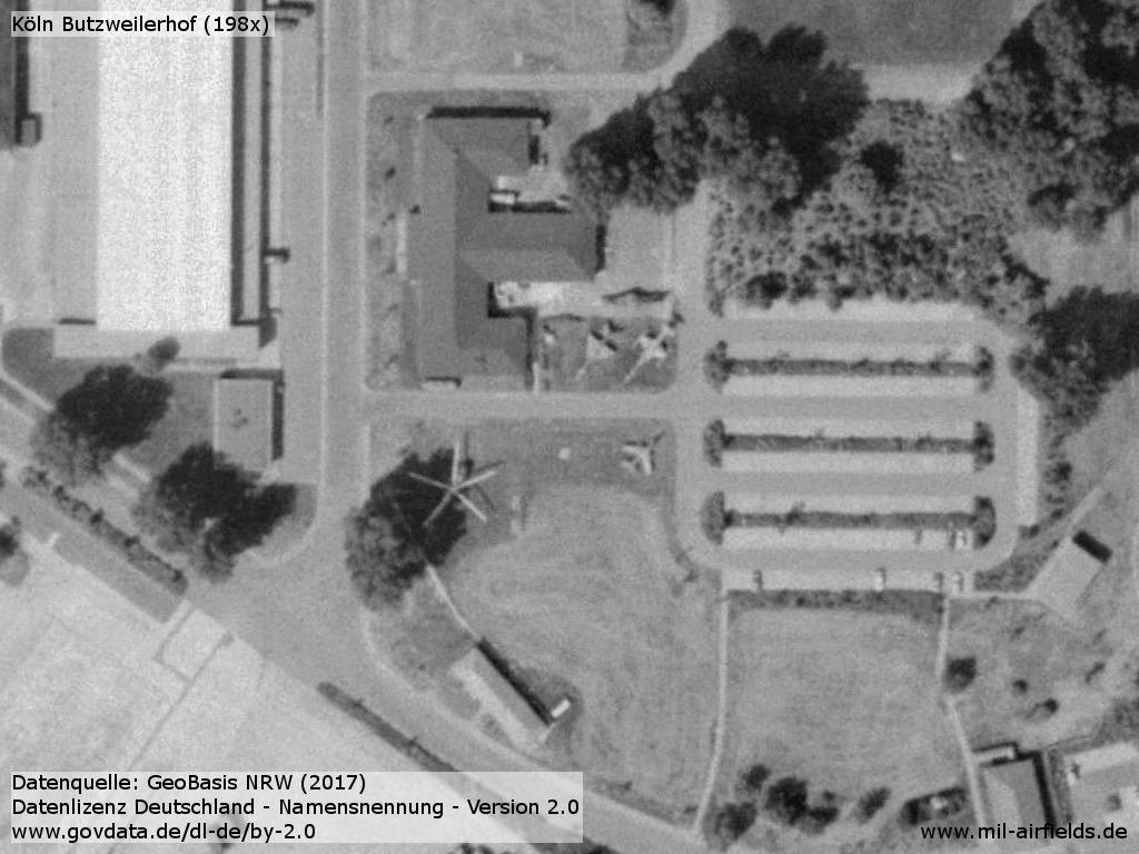
Aviation museum (closed since 1996)
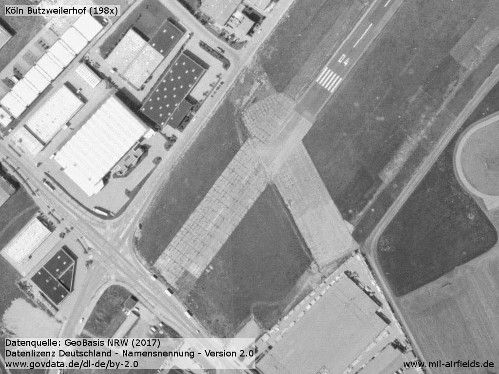
Remainder of the old runway
Southern end of the former runway and former civil grass runway
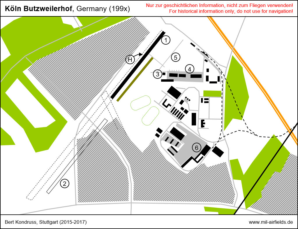
Map of Cologne Butzweilerhof airfield in the early 1990s
| (1) | Runway used by Belgian army aviation |
| (2) | Grass runway of former sports airfield, already closed at this time |
| (3) | Control Tower |
| (4) | Aircraft parking and hangards |
| (5) | Helicopter parking |
| (6) | Old airport |
| (H) | Helicopter landing spot |
Runways
- 04/22: 728 m x 24 m Asphalt
Radio communication
- Tower 139.3, 122.1, 122.5, 366.225
- Radio 43.8
Airspace and procedures
Planned new ICAO code was ETBB.
Additional information
HS, der seine Dienstzeit hier bis 1985 verbrachte, schickte diese ausführlichen Beschreibungen. Vielen Dank!
Barracken
"Während meiner Dienstzeit (hinter diesem auf dem Bild befindlichen Tor) war dort das Verteidigungsbezirkskommando 31 (VBK 31) stationiert und belegte alle Baracken. Ich meine, es waren mal 8 parallele Baracken. Eines davon stürzte an einem verregneten Wochenende ein, nachdem eine Baufirma das Fundament freigegraben hatte. Grund war die Sanierung der Außenmauer, die Feuchtigkeit zog. Die Bodenplatte hatte sowieso schon einen Längsriss und die von den 2 Eingängen abgewandte Seite rutschte dann in den Graben. 2 Toiletten/ Waschhäuser gab es auch noch. Sie befanden sich auf der an den Stirnseiten der Baracken verlaufenden Straße, die zu diesem besagten Tor führt.
Die Engländer nutzten die Baracken angeblich für ihren Labour - Service (andere Quellen). Ich meine, dass dann die Feldjäger dort einzogen. Als das Heeresamt fertig war, verlegten die Feldjäger dorthin und das VBK 31. Es war vorher in der Bismarckstr (?) in einem Mietobjekt untergebracht."
Alte Tankanlage
"Als wieder einmal der große Regen kam, stand das Wasser auf unserer Zufahrtsstraße zum VBK. Mit Halbschuhen war sie nicht begehbar, ohne nasse Füße zu bekommen. Unser Dienststellenleiter, ein Oberst ließ die Standortverwaltung verständigen. Sie beauftragte den Bauunternehmer, nachdem ein Durchspülen des Abwasserrohres nicht ging. Das Rohr war hoffnungslos versandet, vielleicht auch gebrochen. Die Baufirma wollte daraufhin auf kurzem Weg einen Graben zur Betonfläche vor der großen Flugzeughalle ausheben und dort beim Entwässerungskanal anschließen. Die heutigen Freiflächen zwischen Kaserneneinfahrt (Haupttor) und dem Gelände des VBK 31 waren in gleicher Art, wie teilweise heute noch zu sehen, mit Baracken bebaut. Die hier und da noch vorhandenen Fußwege verbanden die Baracken mit der Straße. Auf einem solchen Weg buddelte sich der Bagger durch und stieß nach ein paar Metern auf einen Betondeckel, der unter dem Grand versteckt war. Auch die Standortverwaltung wusste nichts davon. Die Baufirma hat dann den Deckel herausgerissen. Wir schauten in ein tiefes Loch. Unten erkannte man im Wasser mehrere Tanks. Rohrleitungen zeigten den weiteren Verlauf an.
Die Tankanlage sah mir nicht nach "besonders gehärtet" aus. Soll heißen, dass sie nicht bombensicher war. Die Erdbedeckung bei den Tanks lag vielleicht bei einem Meter. Wie tief und in welcher Ausdehnung das gebaut war, wurde damals nicht "erforscht". Auch ob die Tanks noch mit Treibstoff befüllt waren, wurde nicht untersucht. Über das klare Wasser, das vielleicht bis 60 oder 80 cm unter dem Deckel stand, gab es 2 Mutmaßungen. Die eine Variante war, es war schlichtweg abgesoffen (Regenwasser) und die andere Variante, die Tanks hätten durch das Wasser eine besonderen Schutz gegen explodierenden Waffen gehabt. Am Steuerstand war der Deckel vielleicht gerade mal 15 cm stark. Bei den anderen Stellen war es ebenfalls ein Betondeckel mit ähnlicher Dicke. Die Deckel der Tankanlage hatten zum Ausheben in der Mitte einen Eisenring.
Der unter "Hausmeistervertrag" stehende Unternehmer wurde von Forscherdrang gepackt. Mein Hinweis auf 2 weitere Deckel (an der Straße zur Halle und am ehemaligen Speisesaal der Engländer, später Turnhalle) ließen ihn auch diese öffnen. An der Straßenecke befand sich eindeutig der Steuerstand. Eine alte Zeitung "Völk. Beob." (Datum?) und eine Flasche Bier kamen zum Vorschein. Dieser Deckel wurde früher elektrisch geöffnet. Die Mechanik war noch zu sehen. Ein paar Wochen später fand man auch noch die rechts vom Steuerstand gelegene Tankanlage.
Der Bauunternehmer hatte versucht, von der Standortverwaltung oder dem Staatsbauamt noch Unterlagen darüber zu bekommen. Er sagte mir gegenüber, dass seine Bemühungen erfolglos waren. Er meinte, dass so einiges mit GEHEIM gestempelt war und/oder nicht in Feindeshand geraten durfte. Also wurde es beim Vormarsch der Alliierten vernichtet.
Der Bauunternehmer verschloss dann alle Deckel auf Anweisung der Standortverwaltung. Ich glaube zu wissen, dass mindestens der bei dem Speisesaal (wir nutzten sie als Turnhalle) gelegene Steuerstand eine neue Deckelung bekam. Der alte Deckel wurde ja in Unkenntnis der Öffnungsmechanik herausgerissen. Dabei verformte sich der elektromechanische Antrieb erheblich und wurde zerstört."
Today
Use
Closed.
Overview
Conversion of the airfield to a business park 1998 - 2013
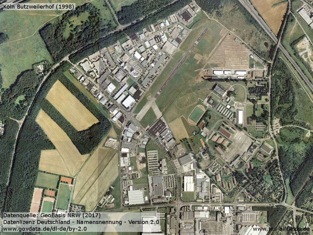
Aerial picture 1998
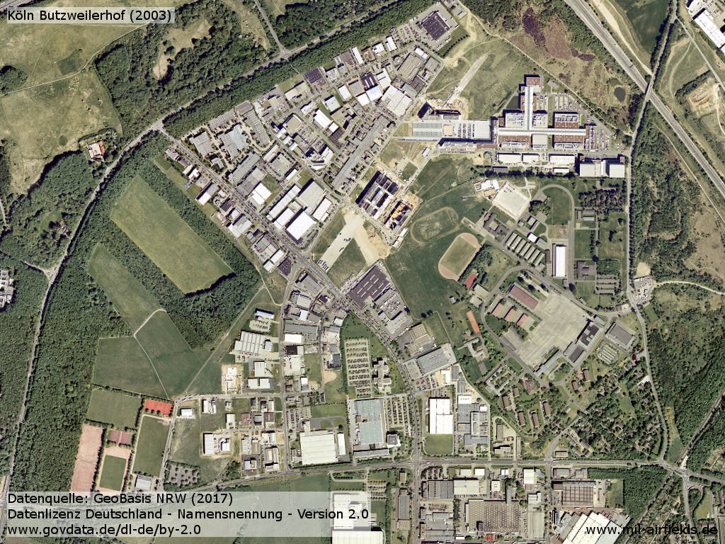
Aerial picture 2003
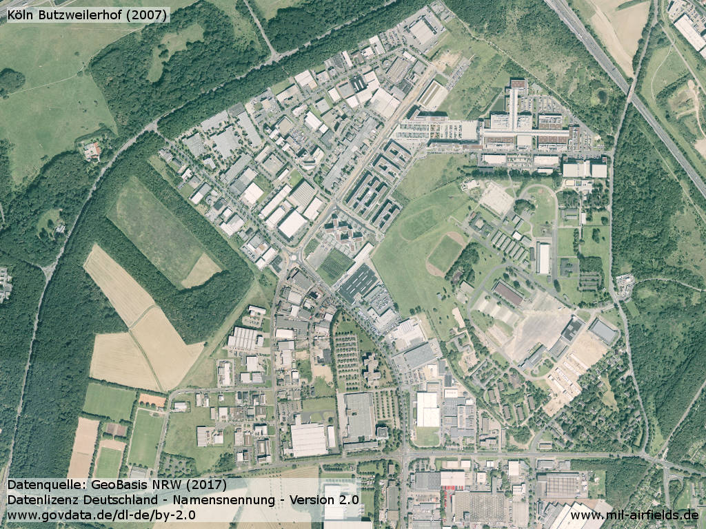
Aerial picture 2007
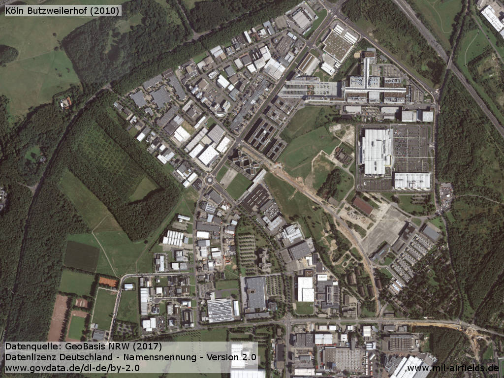
Aerial picture 2010
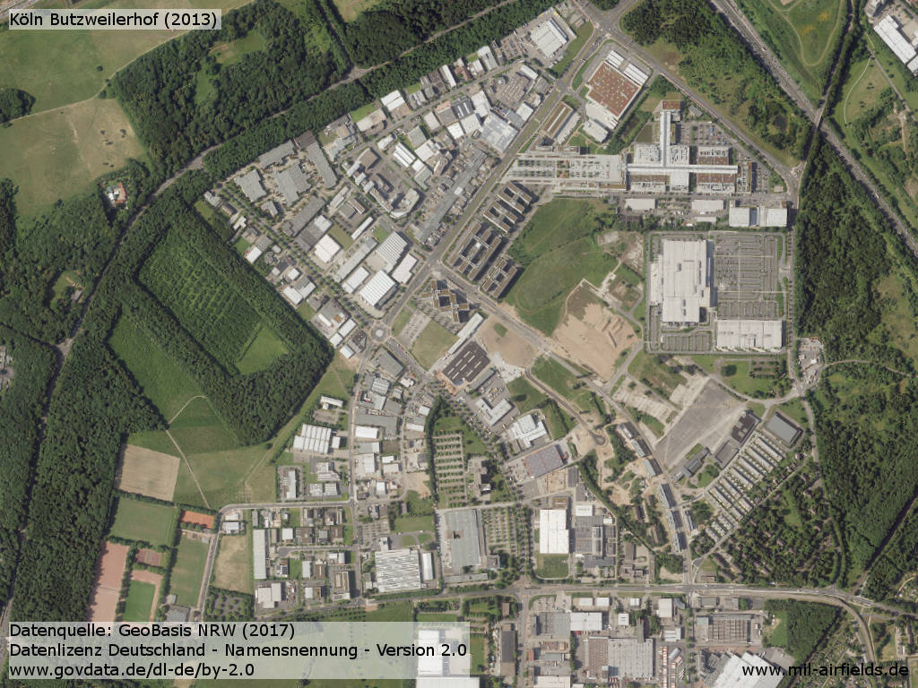
Aerial picture 2013
Images from the time around 2015/2016
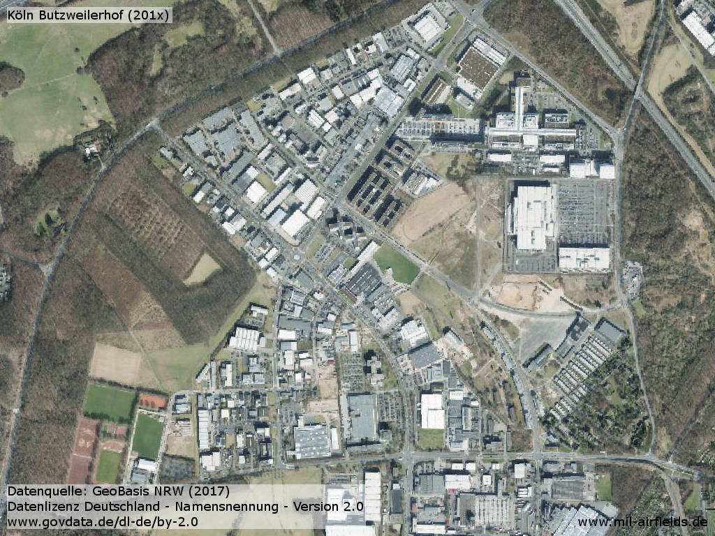
Aerial picture 2015/2016
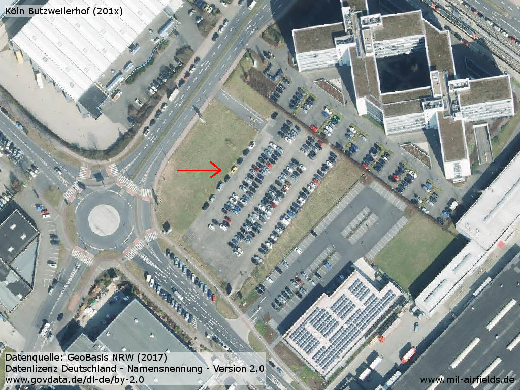
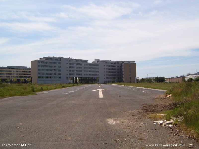
This parking lot is located on a remainder of the runway
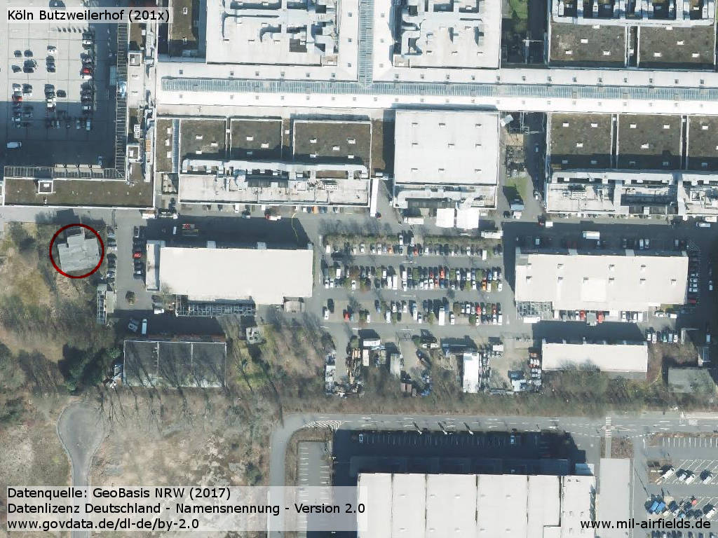
Former Belgian control tower (red circle) and hangars
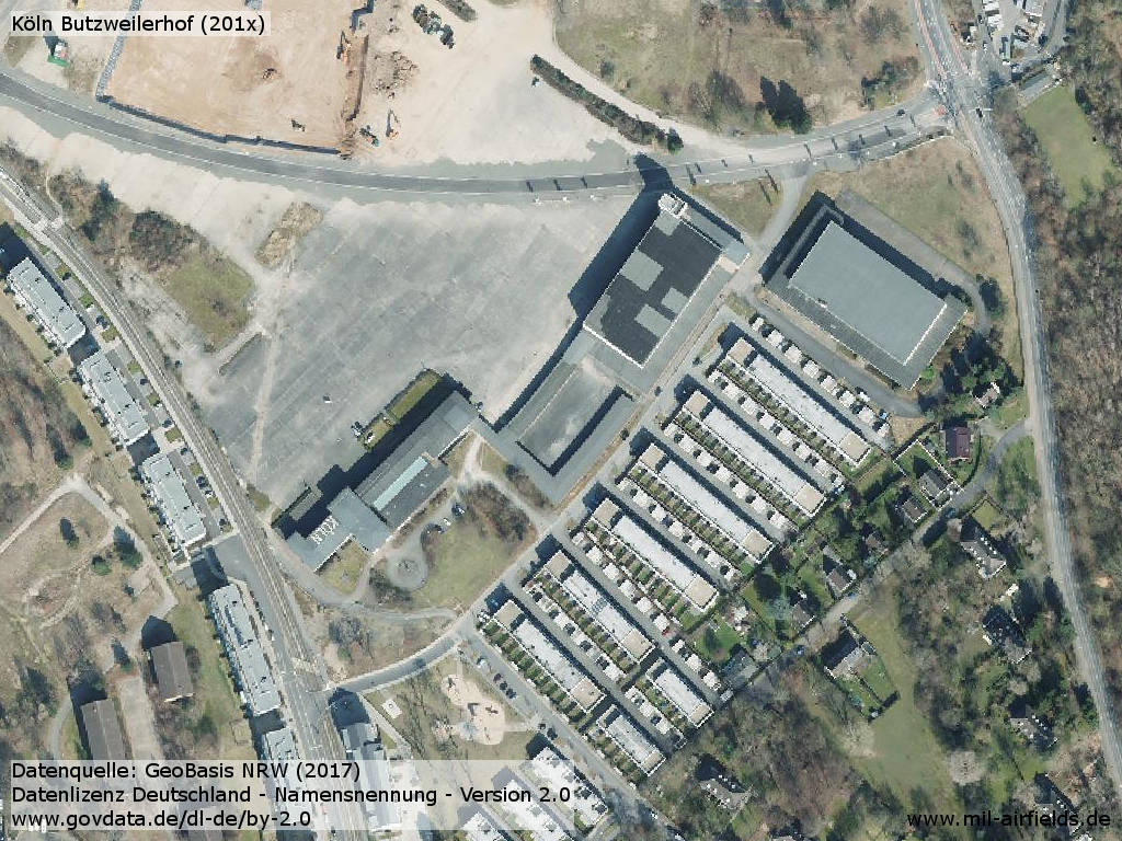
Aerial picture of the former Cologne airport
Images
Pictures (1)
Pictures and descriptions courtesy of Werner Müller http://www.butzweilerhof.com.
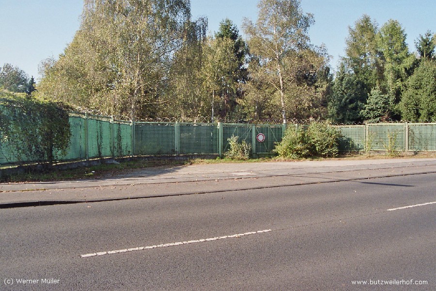
Old gate to the civil airfield from 1926.
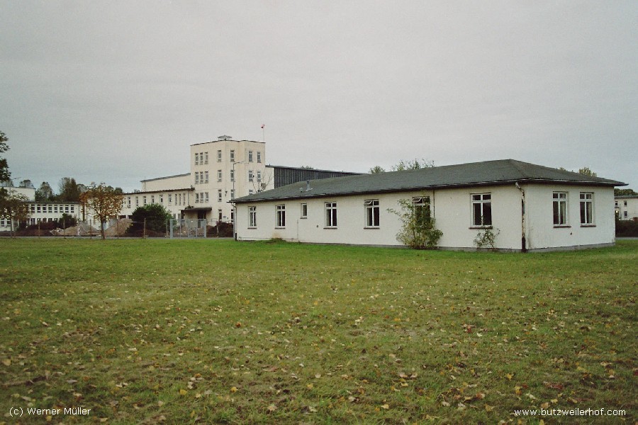
Former gymnasium, which served as aviation museum during the 1990s.
Gymnasium from the opposite side and old tower.
In the foreground was the building where the RAF patrols were housed.
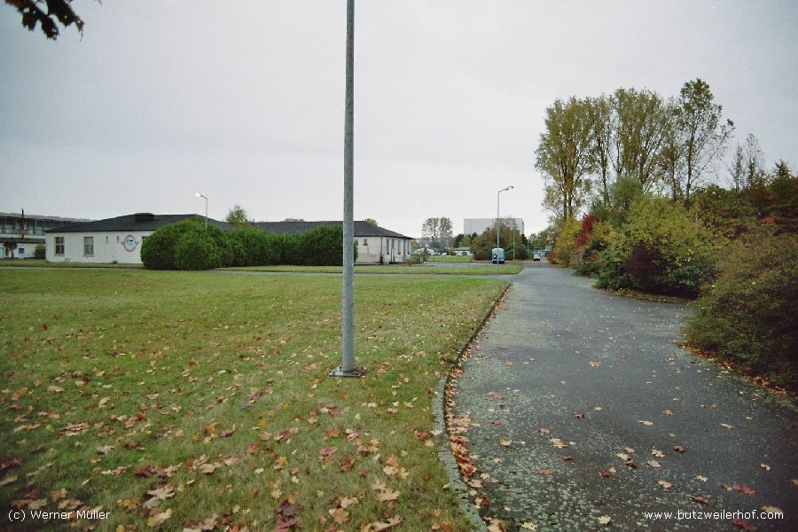
Northern part of the runway.
(1) HS schreibt dazu: Der dort beschriebene Eingang wurde nicht durch die Belgier benutzt! Hier war das Verteidigungsbezirkskommando 31 (VBK 31) stationiert und belegte alle Baracken.
Pictures (2)
Pictures courtesy of Peter Ziegenfuß
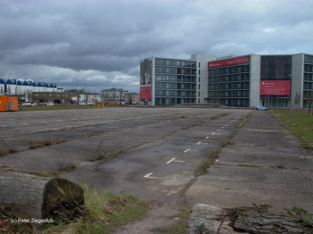
Former runway, now parking
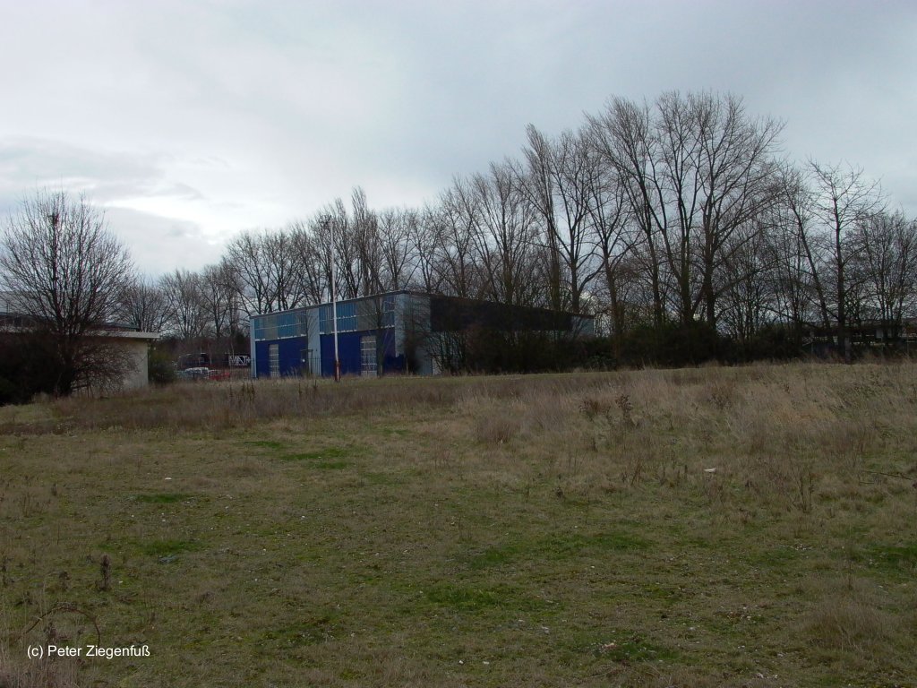
Facilities
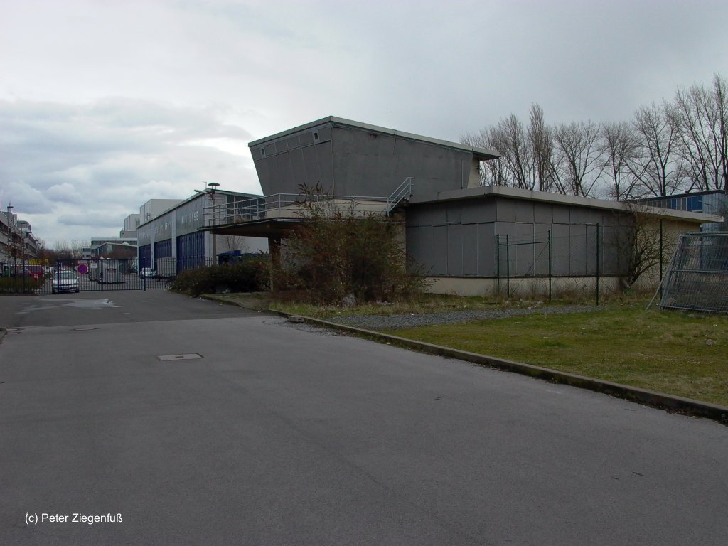
Former tower
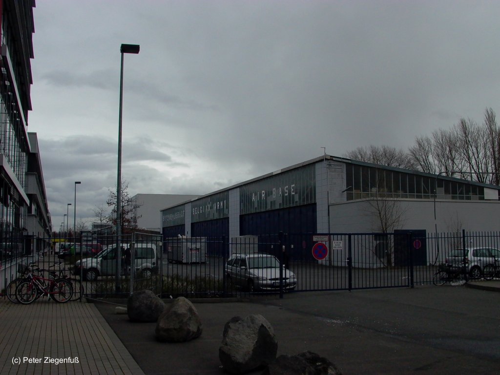
Hangar
Videos
- https://www.youtube.com/watch?v=5SAWgCCOz14 - KÖLN - Butzweiler Hof (Lost Airport)
- https://www.youtube.com/watch?v=2YYTTvaGBbY - La 255 Cie Maint & Dep Lt Avn (1ère partie)
- https://www.youtube.com/watch?v=KjpbzXxDf94 - La 255 Cie Maint & Dep Lt Avn (2ème partie)
- https://www.youtube.com/watch?v=jfUQ2I0ATvE - aeroclub f.b.a quitte Butzweilerhof
- https://www.youtube.com/watch?v=QpOKVgHAOas - 16 esc lt avn Butzweilerhof "The Belgian helicopters are leaving the 'Butz'".
Links
- History of Aviation in Cologne - The Butzweilerhof Airfield - Extensive description of history with many pictures.
- http://www.butzweilerhof.de/
- http://www.luftfahrtarchiv-koeln.de/ - Die Kölner Luftfahrt und der Butzweilerhof Historisches Luftfahrtarchiv Köln
Image sources:
- https://www.geoportal.nrw/ - Geoportal NRW
Bibliography
- Ries, Karl; Dierich, Wolfgang: "Fliegerhorste und Einsatzhäfen der Luftwaffe" Motorbuch Verlag Stuttgart, 1993
Airfields in the vicinity
Categories
Military Airfields GermanyMilitary Airfields in former West GermanyRoyal Air Force (RAF) Bases in GermanyRecommended
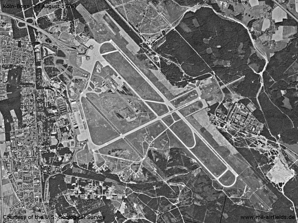
Image credits are shown on the respective target page, click on the preview to open it.
Contents
 Follow mil-airfields on Facebook