For historical information only, do not use for navigation or aviation purposes!
| Coordinates | N521140 E0143540 (WGS84) Google Maps |
| Former East Germany (GDR) | District of Frankfurt/O |
| Federal state | Brandenburg |
| Location indicator | EDAE |
Germany during the Cold War Map
The history of the Cold War airfields: Eisenhüttenstadt
Location of airfield
1,7 km northeast of Pohlitz.
During the Cold War
Use
Main use:
- Airfield of former East German pre-military organization "Gesellschaft für Sport und Technik" (GST) for glider training.
Additionally:
- Helipad 3191 for Radar Maintenance Facility 31 (FuMW-31) of East German Air Force (NVA LSK/LV).
- Helipad 6012 of former East German National People's Army (NVA).
The Radar Maintenance Facility 31 was subordinated to the 1st Air Defense Division (1. LVD) and had its location in Eisenhüttenstadt, An der Unterschleuse, installation number 05/113.
In the 1970s
Overview
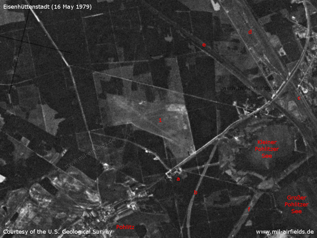
Eisenhüttenstadt Airfield on a US satellite image from 16 May 1979 - 1: airfield; at that time there was no paved runway. Other objects: a: waterworks (mentioned as an obstacle); b: highway Fernverkehrsstraße 112; c: Ziltendorf railway station; d: Eisenhüttenkombinat Ost steelworks marshalling yard; e: Oder-Spree Canal; f: two 110 kV high-voltage power lines. Other: The lakes Kleiner Pohlitzer See and Großer Pohlitzer See already existed before the Eisenhüttenkombinat Ost Combine steelworks was built.
Source: U.S. Geological Survey
In the 1980s and early 1990s
Runways, taxiways, aprons
- 09/27: 1000 m Grass
- 18/36: 800 m Grass
Main takeoff and landing direction for military helipads: 245°..300°
Radio communication
122.0, call sign "Aero Hütte".
Telephone
Stabsnetz S1 9446-859
Teletype
162743
Airspace and procedures
Helipads 3191, 6012: Usable at day during good weather conditions,
Alert time: 60 minutes
Alert time: 60 minutes
Obstacles
Forrest: height 10-15 m
Waterworks: height 15 m
Hangar: height 8 m
Waterworks: height 15 m
Hangar: height 8 m
Today
Use
General aviation.
Links
- https://flugplatz-edae.com/ - Verkehrslandeplatz Pohlitz / EDAE
Airfields in the vicinity
- 030°/10km Kunice: Airfield (Lotnisko Kunice)
- 257°/17km Schneeberg: Helipad 3043 (HSLP / HSLP 3043)
- 334°/19km Frankfurt/O: Helipad 1015 (HSLP / HLP 1015)
- 220°/20km Weichensdorf: Helipad 1033 (HSLP / HLP 1033)
Categories
Military Airfields GermanyMilitary Airfields in former East GermanyHelipads of former National People's ArmyHelipads of former National People's ArmyRecommended

Image credits are shown on the respective target page, click on the preview to open it.
 Follow mil-airfields on Facebook