Fürth: Army Airfield AAF
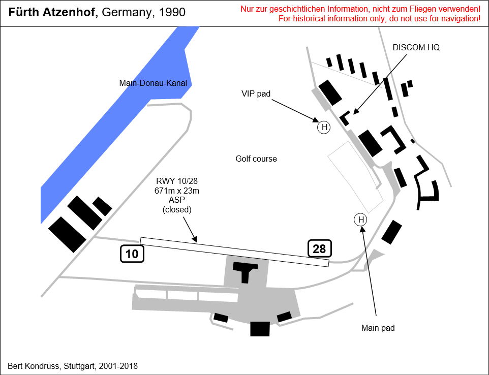
Nürnberg-Fürth Airport, Atzenhof, Monteith Barracks Army Heliport Furth
For historical information only, do not use for navigation or aviation purposes!
| Coordinates | N492949 E0105728 (WGS84) Google Maps |
| Federal state | Bayern (Bavaria) |
Germany during the Cold War
The history of the Cold War airfields: Fürth Atzenhof / Monteith Barracks
Contents
Page 1: From the beginnings to the 1990s ← you are here
Page 2: The former Fürth airfield today
General
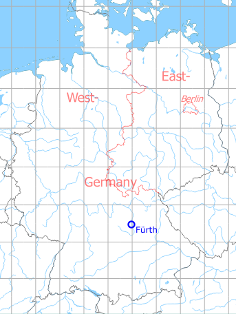
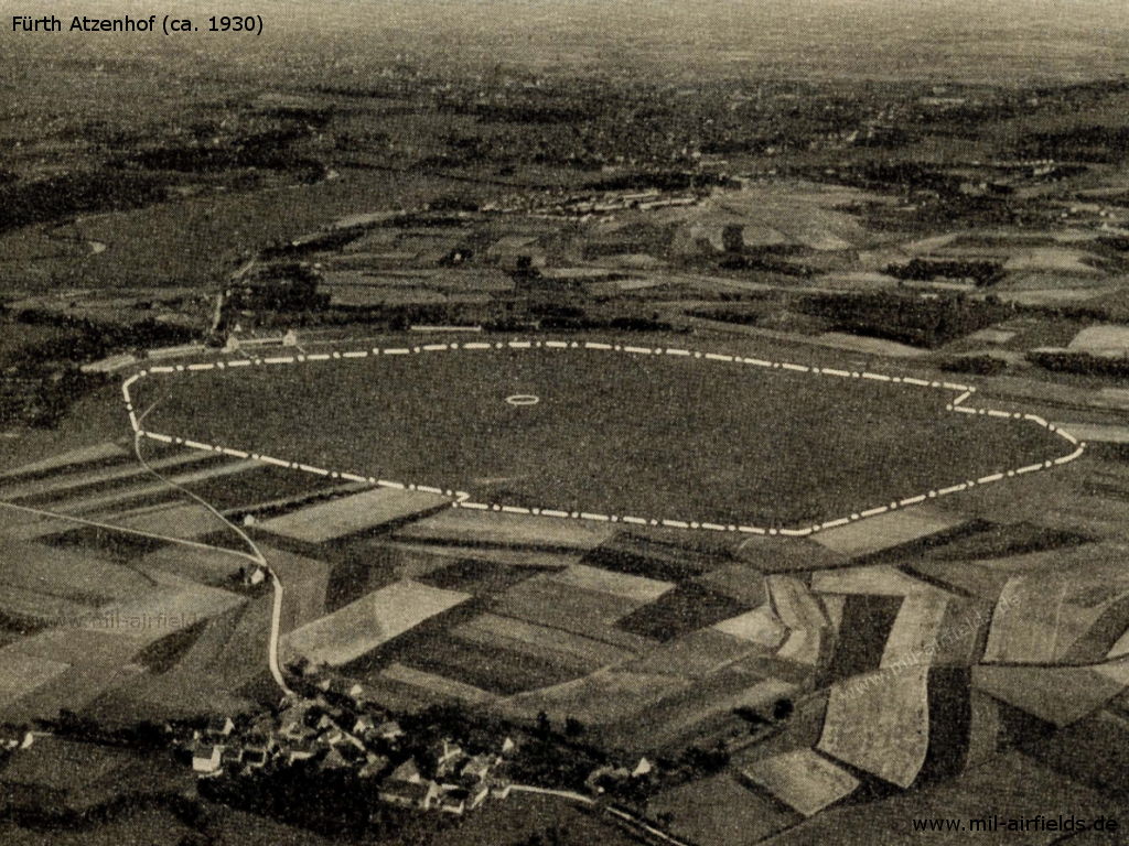
The city of Fürth lies northwest of Nürnberg (Nuremberg), the former Atzenhof airfield is located approx. 4 km northwest of Fürth city centre. The airfield was built during the First World War as a base for the Royal Bavarian Air Force and was commissioned around 1917.
After the First World War, Fürth Atzenhof became the civil airport of Nuremberg. It was served by several domestic German routes, but there were also individual international connections - see 1928 flight schedule below.
Civil air traffic was transferred in 1933 to the newly opened Nuremberg-Marienberg airport. Atzenhof was later taken over by the German Air Force and converted into an air base, which was in use until 1945.
At the end of the Second World War, the airfield was taken over by US troops. The US Army named the barracks "Monteith Barracks" and operated the airfield as Army Airfield (AAF). In the 1980s the site was reduced to a heliport (Army Heliport AHP). In 1993, the US troops left the site, which also ended the use for aviation.
In the years following the withdrawal of the US Army, the site was transformed into the "Golfpark" industrial park. Some old buildings and hangars have been thoroughly renovated and are now used as residential and commercial properties.
During the 1920s/1930s
Use
Nürnberg-Fürth Airport (until 1933).
Operator
City of Nürnberg (Nuremberg).
Administrator
Municipal Airport Administration Nürnberg-Fürth, Fürth i. B., Airport
Transport companies / Airlines
Süddeutsche Luft Hansa A. G., flight control Nürnberg-Fürth, wire address: Lufthansa Fürthbay.
Nordbayerische Verkehrsflug A. G., Fürth,
a) Management
b) Flight control
Wire address: Nordbayerische Verkehrflug Fürthbay.
a) Management
b) Flight control
Wire address: Nordbayerische Verkehrflug Fürthbay.
Situation
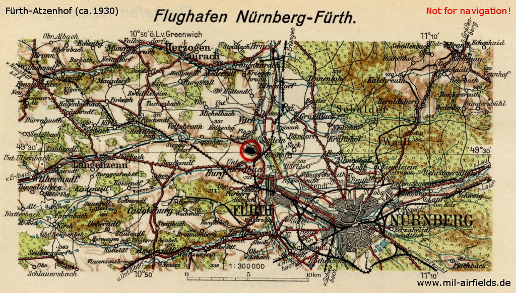
Nürnberg-Fürth Airport on a map from March 1930
Source: Flughandbuch
Overview
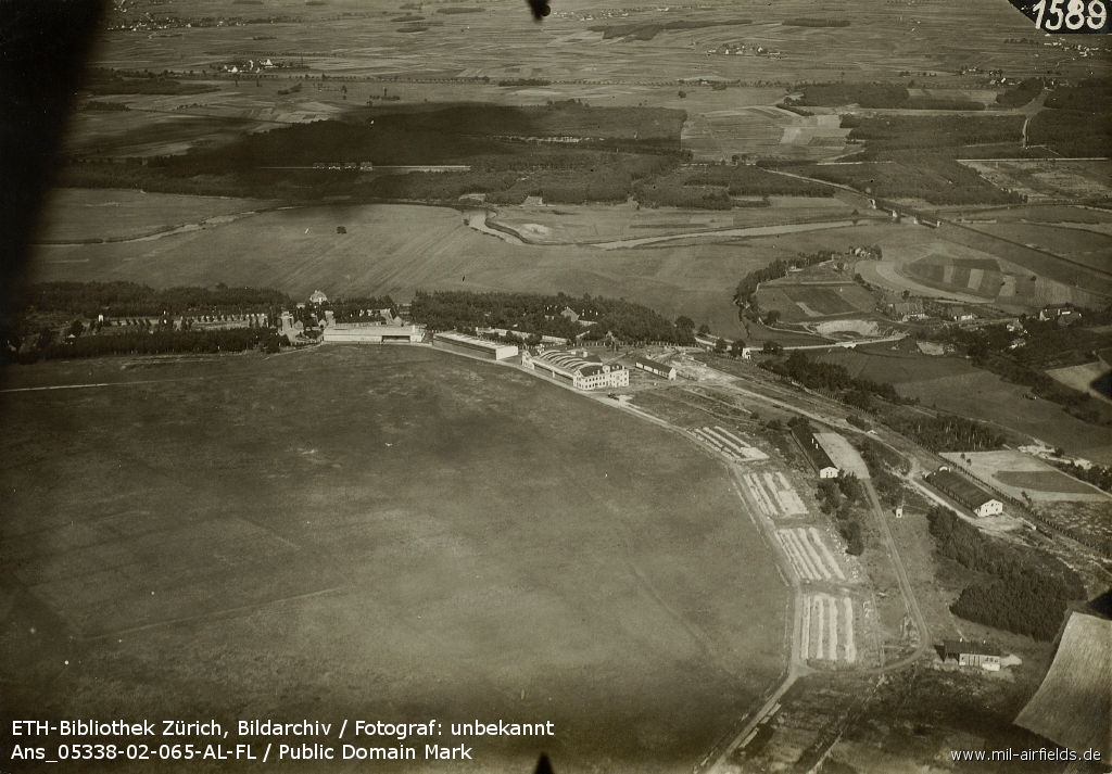
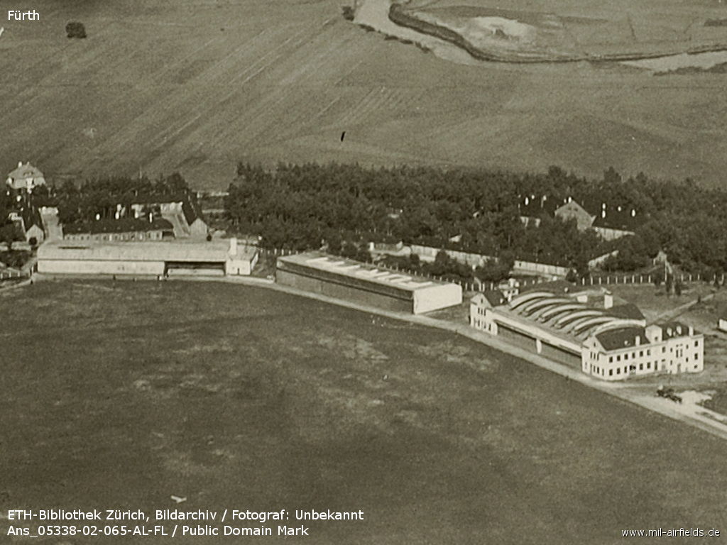
Aerial view, probably 1920s, looking east
Source: ETH-Bibliothek Zürich, Bildarchiv / Fotograf: Unbekannt / Ans_05338-02-065-AL-FL / Public Domain Mark
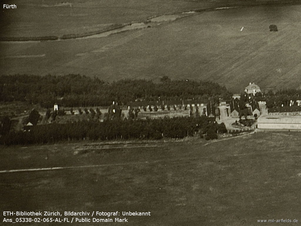
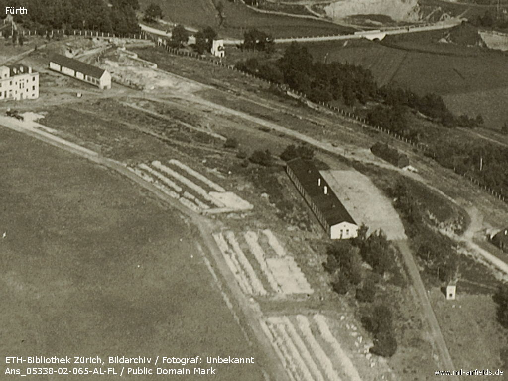
Northeastern part
Source: ETH-Bibliothek Zürich, Bildarchiv / Fotograf: Unbekannt / Ans_05338-02-065-AL-FL / Public Domain Mark
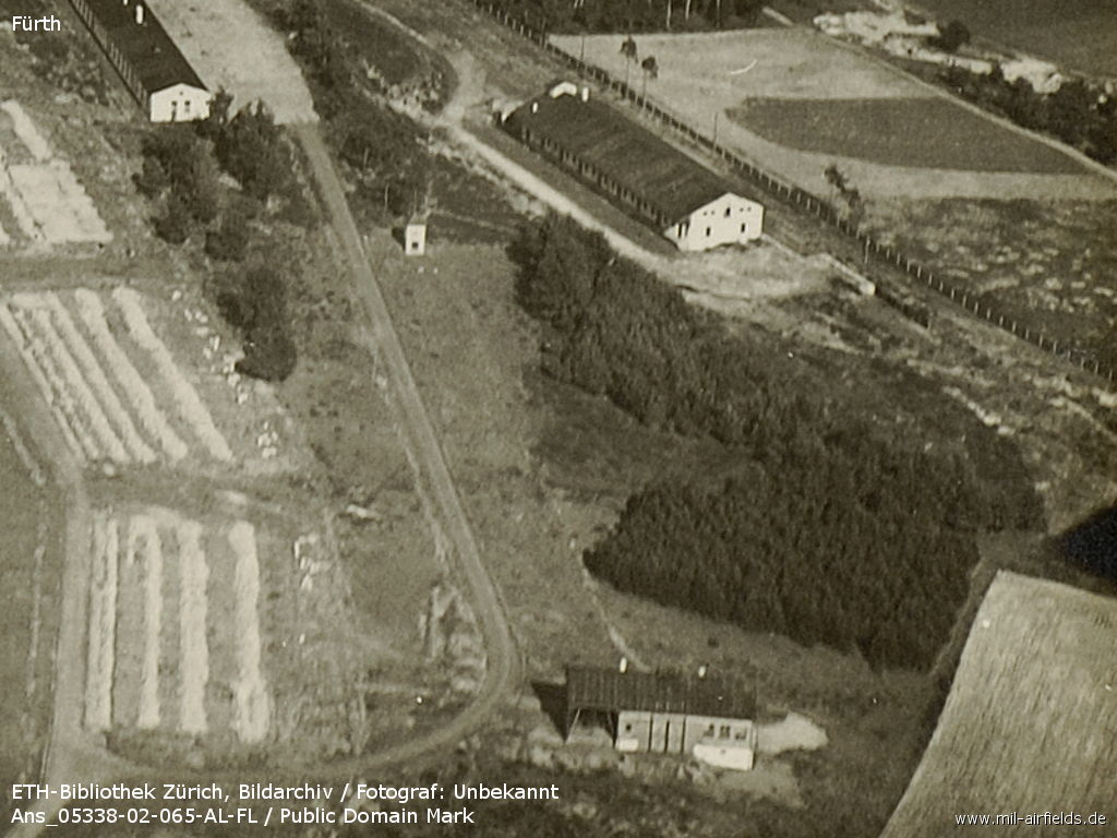
Aircraft hangars
Source: ETH-Bibliothek Zürich, Bildarchiv / Fotograf: Unbekannt / Ans_05338-02-065-AL-FL / Public Domain Mark
The striped areas could be the foundations of demolished hangars
Source: ETH-Bibliothek Zürich, Bildarchiv / Fotograf: Unbekannt / Ans_05338-02-065-AL-FL / Public Domain Mark
Buildings
Source: ETH-Bibliothek Zürich, Bildarchiv / Fotograf: Unbekannt / Ans_05338-02-065-AL-FL / Public Domain Mark
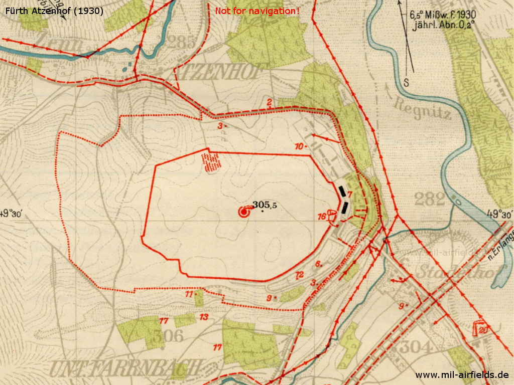
The location of the airport is marked on this map
Source: Flughandbuch
Aerial picture, approx. 1930 - Viewing southeast
Source: Flughandbuch
Airfield characteristics at daytime
Northwest of the city of Fürth. Smoke stove in the center of the movement area and white 30 m circle. Smoke stove in operation weekdays from dawn to dusk; windsock on hangar tower. Hangar buildings as well as barracks to the east and north-east of the movement area. White inscription "Nürnberg - Fürth" on the hangars.
Airfield characteristics at night
No permanent night lighting. On request at the police station, simple landing lights made of green, white and red fires in a row parallel to the wind direction. Land from green via white to red, to the right of the row. Roofs of halls and hangars are illuminated by floodlights.
Runways, taxiways, aprons
Terrain: Grassy turf on light soil. Shortest rolling length: 650 m in north-south direction.
Radio communication
Airport radio and direction finding station: call sign ddg. Transmitter for flight and weather service and direction finding available.
Telephone
Cable station: At the airport radio station.
To reach under Fürth - Bavaria:
Airport administration, South Lufthansa A. G.: 73185
Flight control Nuremberg-Fürth: 73151
Nordbayerische Verkehrsflug A. G.: 70016/17/18,
Police station: 71647,
Aeronautical Observatory: 71687, 73287,
Airport radio and direction finding station: 71654,
Passport office: 71647,
Post office: 72370,
Next doctor (Dr. Lindau): 72163,
First-aid station Fürth: 70277,
Airport restaurant: 72188,
Car call: 70906, 71532, 71471
Hangars
2 hangars, 66.50 x 22.50 m each. Gate opening 20 x 4.5 m (each hangar has 3 gates).
Workshops
A 77.50 x 37.13 m maintenance building with 51.50 x 27.85 m scaffolding hall and 2 gates, each 24.00 x 5.00 m wide. Corresponding workshop and office rooms. Equipped for repairs of metal and wooden aircraft, aircraft engines and instruments. Electric current: 220/380 V three-phase current.
Fuel equipment
1 tank for 46 000 l, 2 tanks for 16 000 l each and 2 tanks for 2 000 l each (petrol, benzene, standard fuel).
Railway siding
Railway siding with end and side ramps.
Fire alarm
At the police station.
First aid in the case of accidents
First aid by the police station, first aid room available, next doctor in Fürth (3 km distance).
Customs, post office, passport
Customs, post and passport office at the airport available.
Accommodation of passengers
In the restaurant at the airport or in Nürnberg or Fürth hotels.
Connections
Shuttle service during planned landings and take-offs. Bus and tram transport of the city of Nürnberg. Taxi cabs on call.
Timetable
Summer 1928
The timetable for summer of 1928 shows the following scheduled flights:
(Days: 1=Monday ... 7=Sunday)
(Days: 1=Monday ... 7=Sunday)
10: Berlin (Tempelhof) - Halle/Leipzig (Schkeuditz) - Fürth (Atzenhof) - Munich (Oberwiesenfeld)
- Deutsche Luft Hansa A.G.:
123456– | Berlin 14:05 - 15:15 Halle/Leipzig 15:30 - 17:20 Fürth 17:35 - 18:55 Munich - Deutsche Luft Hansa A.G.:
123456– | Munich 07:00 - 08:20 Fürth 08:35 - 10:25 Halle/Leipzig 10:40 - 11:50 Berlin
45: Munich (Oberwiesenfeld) - Fürth (Atzenhof) - Frankfurt/M (Rebstock) - Cologne (Butzweilerhof) - Essen/Mühlheim
- Deutsche Luft Hansa A.G.:
Munich 14:10 - 15:30 Fürth 15:45 - 17:15 Frankfurt/M 17:35 - 18:45 Cologne 19:00 - 19:30 Essen/Mühlheim - Deutsche Luft Hansa A.G.:
Essen/Mühlheim 07:15 - 07:45 Cologne 08:00 - 09:10 Frankfurt/M 09:30 - 11:00 Fürth 11:15 - 12:35 Munich
47: Munich (Oberwiesenfeld) - Regensburg (Prüfening) - Fürth (Atzenhof)
- Deutsche Luft Hansa A.G.:
123456– | Munich 17:25 - 18:20 Regensburg 18:30 - 19:15 Fürth - Deutsche Luft Hansa A.G.:
123456– | Fürth 07:00 - 07:45 Regensburg 07:55 - 08:50 Munich
101: Hannover (Vahrenwald) - Erfurt (Nord) - Fürth (Atzenhof) - Munich (Oberwiesenfeld)
- Deutsche Luft Hansa A.G.:
123456– | Hannover 12:40 - 14:10 Erfurt 14:25 - 15:55 Fürth 16:10 - 17:30 Munich - Deutsche Luft Hansa A.G.:
123456– | Munich 10:05 - 11:25 Fürth 11:40 - 13:10 Erfurt 13:25 - 14:55 Hannover
140: Dresden (Heller) - Chemnitz - Plauen - Fürth (Atzenhof)
- Deutsche Luft Hansa A.G.:
123456– | Dresden 08:25 - 09:00 Chemnitz 09:10 - 09:45 Plauen 09:55 - 11:05 Fürth - Deutsche Luft Hansa A.G.:
123456– | Fürth 15:45 - 16:55 Plauen 17:05 - 17:40 Chemnitz 17:55 - 18:30 Dresden
301: Fürth (Atzenhof) - Bayreuth (Laineck) - Hof (Hohensaas) - Plauen - Zwickau: Airfield - Leipzig (Mockau)
- Nordbayerische Verkehrsflug G. m. b. H.:
123456– | Fürth 07:05 - 07:40 Bayreuth 07:55 - 08:15 Hof 08:30 - 08:45 Plauen 09:00 - 09:20 Zwickau: Airfield 09:35 - 10:15 Leipzig
On request, landing will be at Leipzig-Schkeuditz - Nordbayerische Verkehrsflug G. m. b. H.:
123456– | Fürth - Bayreuth - Hof - Plauen - Zwickau: Airfield - Leipzig
On request, landing will be at Leipzig-Schkeuditz - Nordbayerische Verkehrsflug G. m. b. H.:
123456– | Leipzig 15:45 - 16:25 Zwickau: Airfield 16:40 - 17:00 Plauen 17:15 - 17:30 Hof 17:45 - 18:05 Bayreuth 18:20 - 18:55 Fürth
On request, landing will be at Leipzig-Schkeuditz
302: Fürth (Atzenhof) - Bamberg - Coburg - Plauen - Rudolstadt/Saalfeld - Leipzig (Mockau)
- Nordbayerische Verkehrsflug G. m. b. H.:
123456– | Fürth 06:45 - 07:10 Bamberg 07:25 - 07:45 Coburg 08:00 - 08:40 Plauen 08:55 - 09:25 Rudolstadt/Saalfeld 09:40 - 10:30 Leipzig
On request, landing will be at Leipzig-Schkeuditz - Nordbayerische Verkehrsflug G. m. b. H.:
123456– | Leipzig 15:30 - 16:20 Rudolstadt/Saalfeld 16:35 - 17:05 Plauen 17:20 - 18:00 Coburg 18:15 - 18:35 Bamberg 18:50 - 19:15 Fürth
On request, landing will be at Leipzig-Schkeuditz
304: Rudolstadt/Saalfeld - Weimar - Erfurt (Nord) - Meiningen - Schweinfurt/Bad Kissingen - Fürth (Atzenhof)
- Nordbayerische Verkehrsflug G. m. b. H.:
123456– | Rudolstadt/Saalfeld 07:20 - 07:40 Weimar 07:50 - 08:00 Erfurt 08:15 - 09:00 Meiningen 09:20 - 09:55 Schweinfurt/Bad Kissingen 10:10 - 10:55 Fürth
Flights to Weimar on demand only - Nordbayerische Verkehrsflug G. m. b. H.:
123456– | Fürth 07:25 - 08:10 Schweinfurt/Bad Kissingen 08:25 - 09:00 Meiningen 09:15 - 10:00 Erfurt 10:15 - 10:25 Weimar 10:35 - 10:55 Rudolstadt/Saalfeld
Flights to Weimar on demand only
462: Paris - Strasbourg - Fürth (Atzenhof) - Praha (Kbely) - Wien - Budapest - Belgrad - Sofia - Bucharest - Konstantinopel
- Compagnie Internationale de Navigation Aérienne:
123456– | Paris 06:30 - 09:30 Strasbourg 10:00 - 12:00 Fürth 12:30 - 14:30 Praha 15:00 - 17:45 Wien 07:30 - 09:45 Budapest 10:15 - 13:00 Belgrad - Sofia - Bucharest - Konstantinopel - Compagnie Internationale de Navigation Aérienne:
123456– | Konstantinopel - Bucharest - Sofia - Belgrad - Budapest - Wien - Praha - Fürth - Strasbourg - Paris - Compagnie Internationale de Navigation Aérienne:
123456– | Konstantinopel - Bucharest - Sofia - Belgrad 12:15 - 15:00 Budapest 15:30 - 17:45 Wien 07:15 - 10:00 Praha 10:45 - 12:45 Fürth 13:15 - 15:15 Strasbourg 15:45 - 18.45 Paris
Departures and arrivals by time
| Days | Time | Dep/Arr | Route | Operator | Aircraft type | to/from |
|---|---|---|---|---|---|---|
| 123456– | 06:45 | Dep | 302 | Nordbayerische Verkehrsflug G. m. b. H. | Bamberg - Coburg - Plauen - Rudolstadt/Saalfeld - Leipzig | |
| 123456– | 07:00 | Dep | 47 | Deutsche Luft Hansa A.G. | Regensburg - Munich | |
| 123456– | 07:05 | Dep | 301 | Nordbayerische Verkehrsflug G. m. b. H. | Bayreuth - Hof - Plauen - Zwickau: Airfield - Leipzig | |
| 123456– | 07:25 | Dep | 304 | Nordbayerische Verkehrsflug G. m. b. H. | Schweinfurt/Bad Kissingen - Meiningen - Erfurt - Weimar - Rudolstadt/Saalfeld | |
| 123456– | 08:20 | Arr | 10 | Deutsche Luft Hansa A.G. | Munich | |
| 123456– | 08:35 | Dep | 10 | Deutsche Luft Hansa A.G. | Halle/Leipzig - Berlin | |
| 123456– | 10:55 | Arr | 304 | Nordbayerische Verkehrsflug G. m. b. H. | Rudolstadt/Saalfeld - Weimar - Erfurt - Meiningen - Schweinfurt/Bad Kissingen | |
| 11:00 | Arr | 45 | Deutsche Luft Hansa A.G. | Essen/Mühlheim - Cologne - Frankfurt/M | ||
| 123456– | 11:05 | Arr | 140 | Deutsche Luft Hansa A.G. | Dresden - Chemnitz - Plauen | |
| 11:15 | Dep | 45 | Deutsche Luft Hansa A.G. | Munich | ||
| 123456– | 11:25 | Arr | 101 | Deutsche Luft Hansa A.G. | Munich | |
| 123456– | 11:40 | Dep | 101 | Deutsche Luft Hansa A.G. | Erfurt - Hannover | |
| 123456– | 12:00 | Arr | 462 | Compagnie Internationale de Navigation Aérienne | Paris - Strasbourg | |
| 123456– | 12:30 | Dep | 462 | Compagnie Internationale de Navigation Aérienne | Praha - Wien - Budapest - Belgrad - Sofia - Bucharest - Konstantinopel | |
| 123456– | 12:45 | Arr | 462 | Compagnie Internationale de Navigation Aérienne | Konstantinopel - Bucharest - Sofia - Belgrad - Budapest - Wien - Praha | |
| 123456– | 13:15 | Dep | 462 | Compagnie Internationale de Navigation Aérienne | Strasbourg - Paris | |
| 15:30 | Arr | 45 | Deutsche Luft Hansa A.G. | Munich | ||
| 123456– | 15:45 | Dep | 140 | Deutsche Luft Hansa A.G. | Plauen - Chemnitz - Dresden | |
| 15:45 | Dep | 45 | Deutsche Luft Hansa A.G. | Frankfurt/M - Cologne - Essen/Mühlheim | ||
| 123456– | 15:55 | Arr | 101 | Deutsche Luft Hansa A.G. | Hannover - Erfurt | |
| 123456– | 16:10 | Dep | 101 | Deutsche Luft Hansa A.G. | Munich | |
| 123456– | 17:20 | Arr | 10 | Deutsche Luft Hansa A.G. | Berlin - Halle/Leipzig | |
| 123456– | 17:35 | Dep | 10 | Deutsche Luft Hansa A.G. | Munich | |
| 123456– | 18:55 | Arr | 301 | Nordbayerische Verkehrsflug G. m. b. H. | Leipzig - Zwickau: Airfield - Plauen - Hof - Bayreuth | |
| 123456– | 19:15 | Arr | 47 | Deutsche Luft Hansa A.G. | Munich - Regensburg | |
| 123456– | 19:15 | Arr | 302 | Nordbayerische Verkehrsflug G. m. b. H. | Leipzig - Rudolstadt/Saalfeld - Plauen - Coburg - Bamberg |
Images
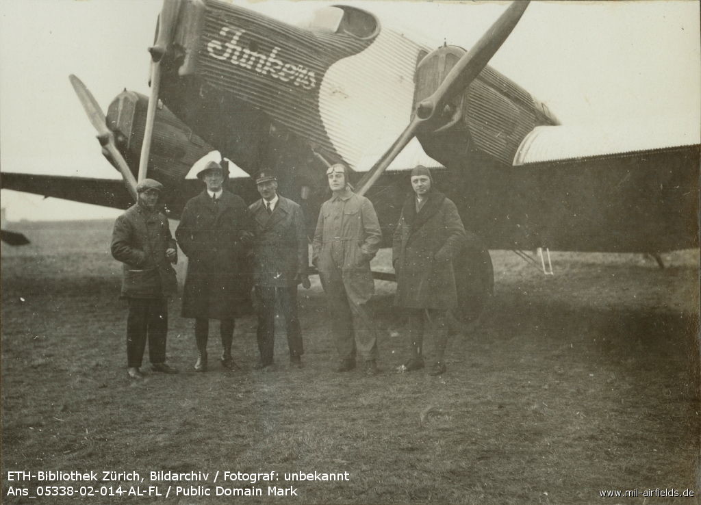
'At the "Large Aircraft School", Fürth airfield'
Source: ETH-Bibliothek Zürich, Bildarchiv / Fotograf: Unbekannt / Ans_05338-02-014-AL-FL / Public Domain Mark
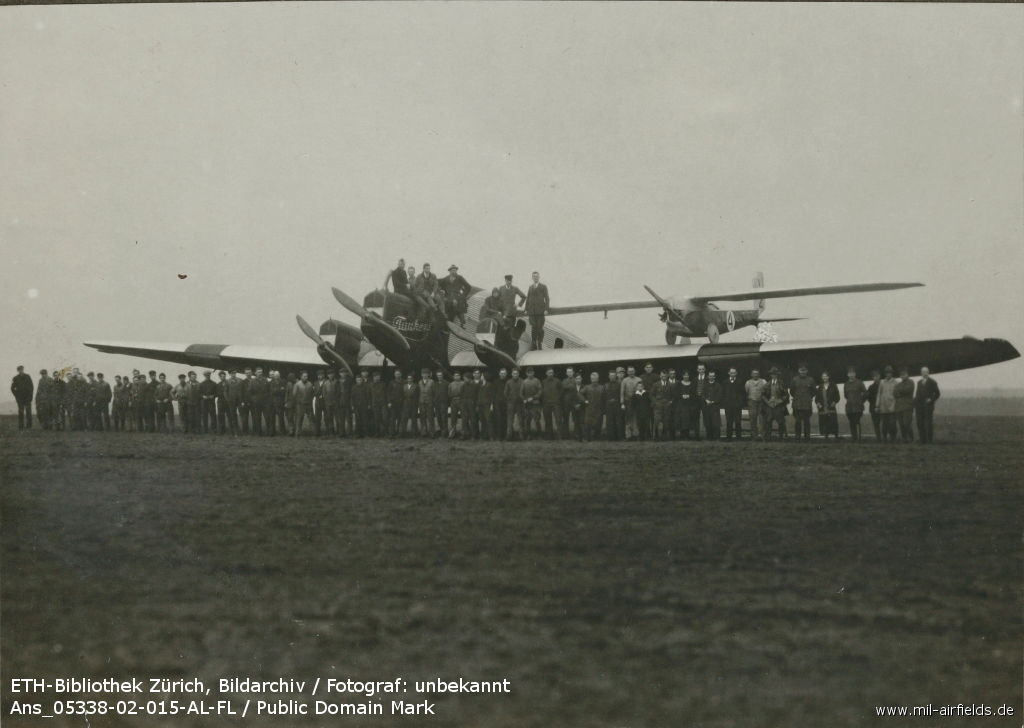
'At the "Large Aircraft School", Fürth airfield' - The first Junkers G23 aircraft in Fürth. On the wing is a small Akaflieg Darmstadt aircraft. Probably in the 1920s
Source: ETH-Bibliothek Zürich, Bildarchiv / Fotograf: Unbekannt / Ans_05338-02-015-AL-FL / Public Domain Mark
During World War II
Use
Luftwaffe Fliegerhorst (air base).
Situation
Atzenhof air base in World War II on a US map from 1944
Source: McMaster University Library Digital Archive, Lizenz: Creative Commons Attribution-NonCommercial 2.5 CC BY-NC 2.5 CA
During the Cold War
Use
US Army airfield and heliport.
In the 1950s
Situation
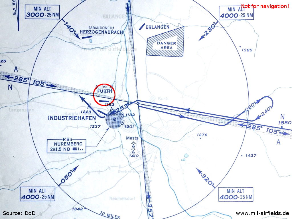
Approach chart for Fürth Industriehafen Airport, located south of Atzenhof, January 1952 - Fürth Atzenhof Airfield is shown as closed here.
Source: DoD
Overview
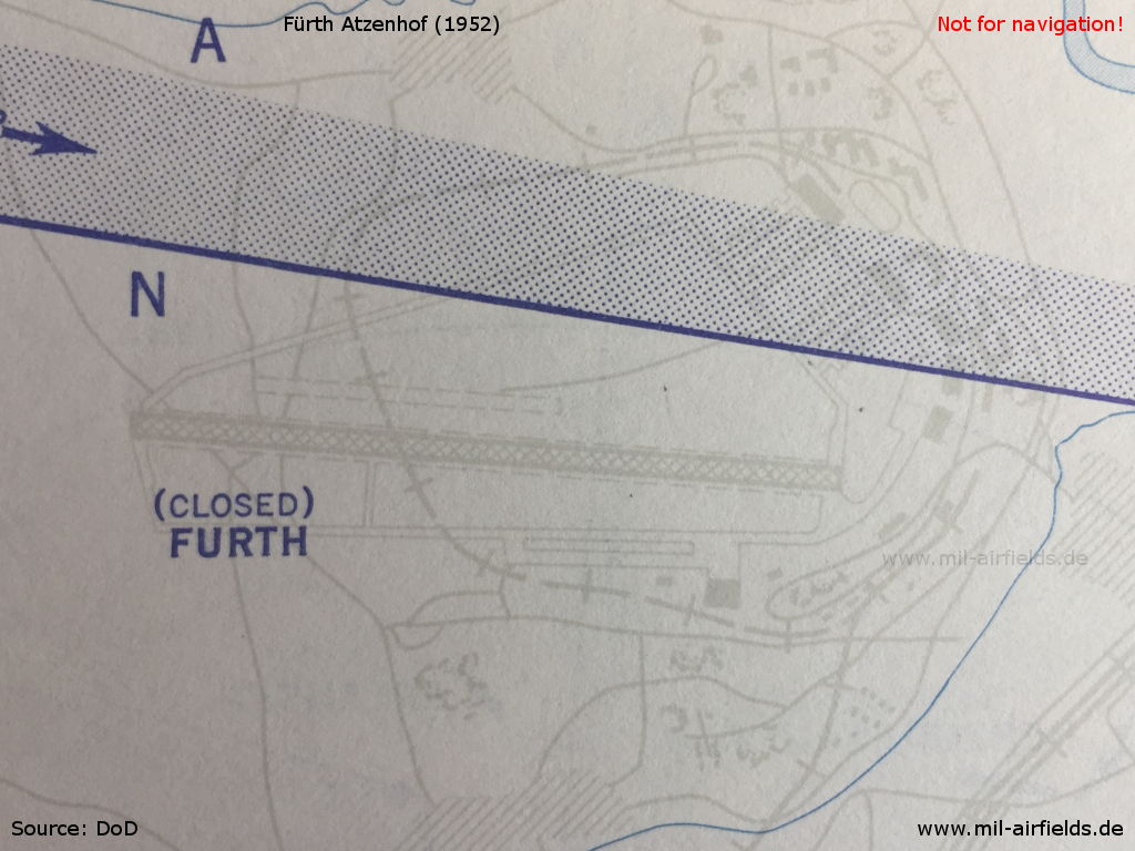
On this map from January 1952 the airfield is shown as closed. - The surface of the runway is perforated steel plates (PSP). A railway track leads over the runway.
Source: DoD
Fürth Atzenhof airfield on a US map from 1954 - Composed of two map sheets. The Main Danube Canal did not exist at this time.
Source: AMS M841 GSGS 4414, Courtesy Harold B. Lee Library, Brigham Young University
In the 1960s
Overview
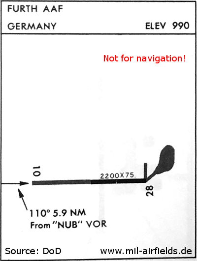
Fürth Army Airfield on a map from December 1968 - The length of the runway is 671 m (2,200 ft).
Source: DoD
In the 1970s
Situation
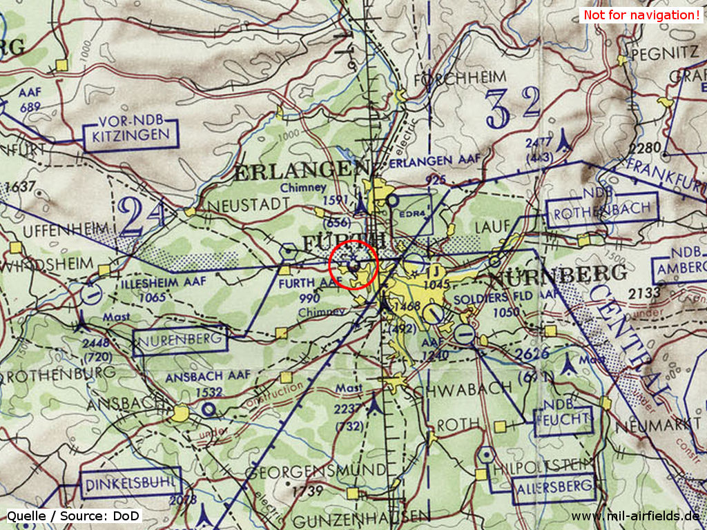
Fürth Army Airfield (AAF) on a map of the US Department of Defense from 1972
Source: ONC E-2 (1972), Perry-Castañeda Library Map Collection, University of Texas at Austin
Overview
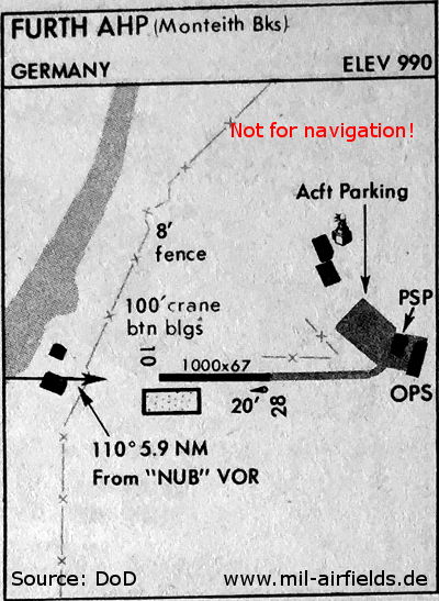
September 1977 - This map shows the Main-Danube Canal in the west. The site has become an Army Heliport (AHP), the length of the runway has been reduced to 305 m (1000 ft).
Source: DoD
Runways
- 10/28: 671 m x 23 m Asphalt
In the 1980s and early 1990s
Overview
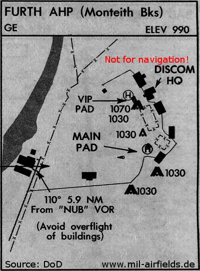
May 1988 - Meanwhile there is no runway any more, only two helipads are shown (VIP PAD and MAIN PAD)
Source: DoD
Situation in the early 1990s
Telephone
DSN 460 -4xxx
Contents
Page 1: From the beginnings to the 1990s ← you are here
Page 2: The former Fürth airfield today
 Follow mil-airfields on Facebook