For historical information only, do not use for navigation or aviation purposes!
| Coordinates | N510933 E0145704 (WGS84) Google Maps |
| Former East Germany (GDR) | District of Dresden |
| Federal state | Sachsen (Saxony) |
| Region | Lausitz / Oberlausitz, Neiße |
| Location indicator | EDBX |

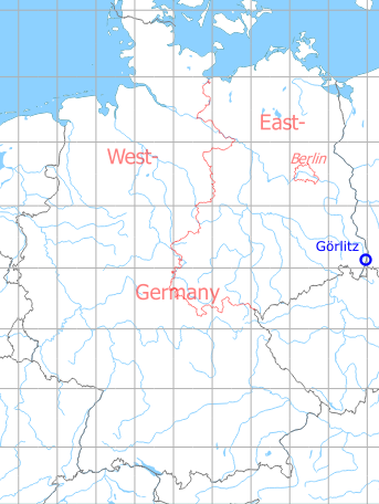
Germany during the Cold War Map
The history of the Cold War airfields: Görlitz
Location of airfield
At the north-western edge of Goerlitz.
During the 1920s/1930s
Use
Airport.
Timetable
Summer 1928
The timetable for summer of 1928 shows the following scheduled flights:
(Days: 1=Monday ... 7=Sunday)
(Days: 1=Monday ... 7=Sunday)
157: Görlitz - Dresden (Heller) - Halle/Leipzig (Schkeuditz)
- Deutsche Luft Hansa A.G.:
123456– | Görlitz 07:35 - 08:15 Dresden 08:25 - 09:15 Halle/Leipzig - Deutsche Luft Hansa A.G.:
123456– | Halle/Leipzig 15:55 - 16:45 Dresden 16:55 - 17:35 Görlitz
160: Breslau (Gandau) - Riesengebirge/Hirschberg - Görlitz - Cottbus - Berlin (Tempelhof)
- Deutsche Luft Hansa A.G.:
123456– | Breslau 06:00 - 06:45 Riesengebirge/Hirschberg 06:55 - 07:25 Görlitz 07:35 - 08:15 Cottbus 08:25 - 09:15 Berlin - Deutsche Luft Hansa A.G.:
123456– | Berlin 15:55 - 16:45 Cottbus 16:55 - 17:35 Görlitz 17:45 - 18:15 Riesengebirge/Hirschberg 18:25 - 19:10 Breslau
Departures and arrivals by time
| Days | Time | Dep/Arr | Route | Operator | Aircraft type | to/from |
|---|---|---|---|---|---|---|
| 123456– | 07:25 | Arr | 160 | Deutsche Luft Hansa A.G. | Breslau - Riesengebirge/Hirschberg | |
| 123456– | 07:35 | Dep | 160 | Deutsche Luft Hansa A.G. | Cottbus - Berlin | |
| 123456– | 07:35 | Dep | 157 | Deutsche Luft Hansa A.G. | Dresden - Halle/Leipzig | |
| 123456– | 17:35 | Arr | 160 | Deutsche Luft Hansa A.G. | Berlin - Cottbus | |
| 123456– | 17:35 | Arr | 157 | Deutsche Luft Hansa A.G. | Halle/Leipzig - Dresden | |
| 123456– | 17:45 | Dep | 160 | Deutsche Luft Hansa A.G. | Riesengebirge/Hirschberg - Breslau |
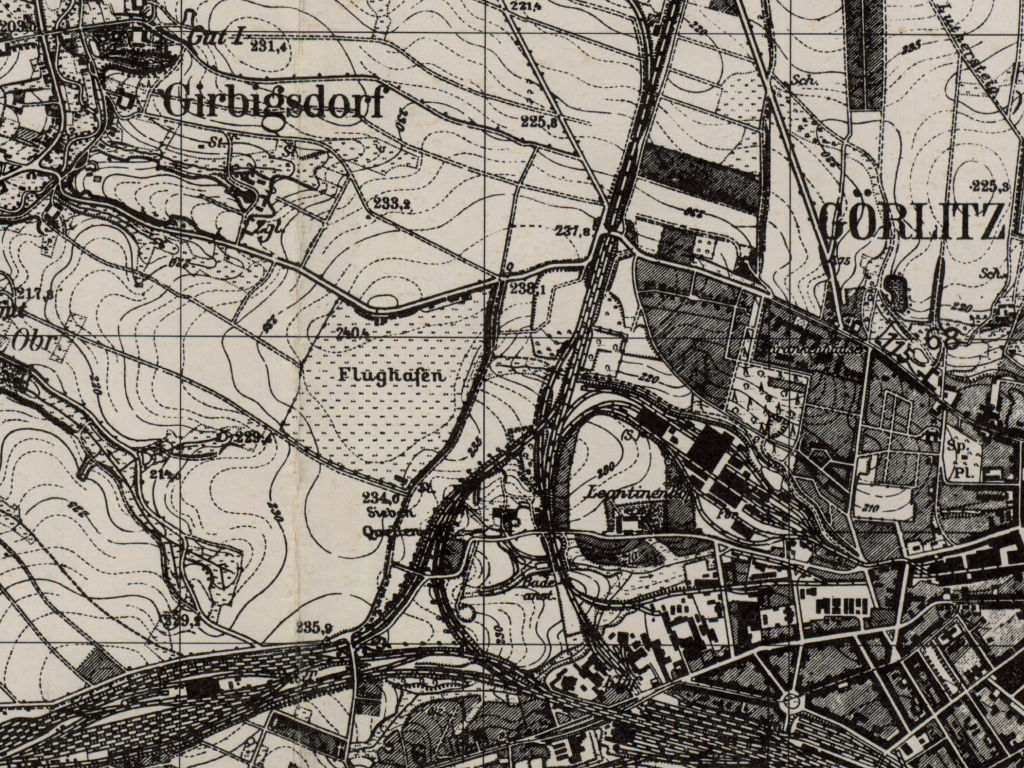
During World War II
Use
Started as civilian airfield, later taken over by Luftwaffe and extended to an air base.
Situation
Görlitz Airfield in World War II on a US map from 1944
Source: McMaster University Library Digital Archive, Lizenz: Creative Commons Attribution-NonCommercial 2.5 CC BY-NC 2.5 CA
Overview
Görlitz airfield on a US map from 1952
Source: AMS M841 GSGS 4414, Courtesy Harold B. Lee Library, Brigham Young University
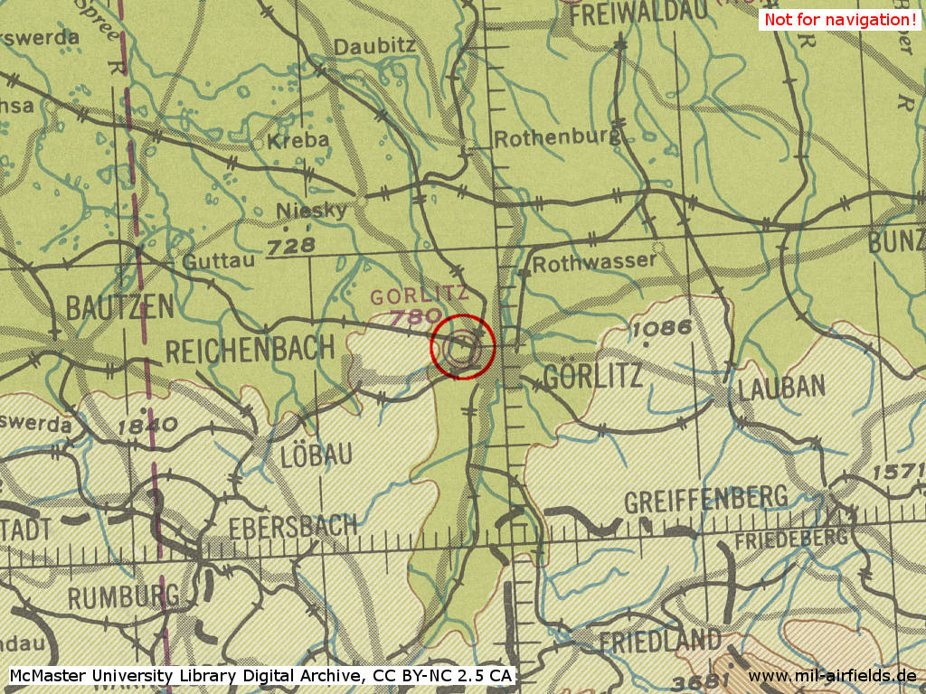
During the Cold War
Use
Airfield of the former East German pre-military mass organization Gesellschaft für Sport und Technik (GST, "Sport and Technology Association") until 1979. Then kept ready as helipad for the National People's Army.
In the 1960s
Overview
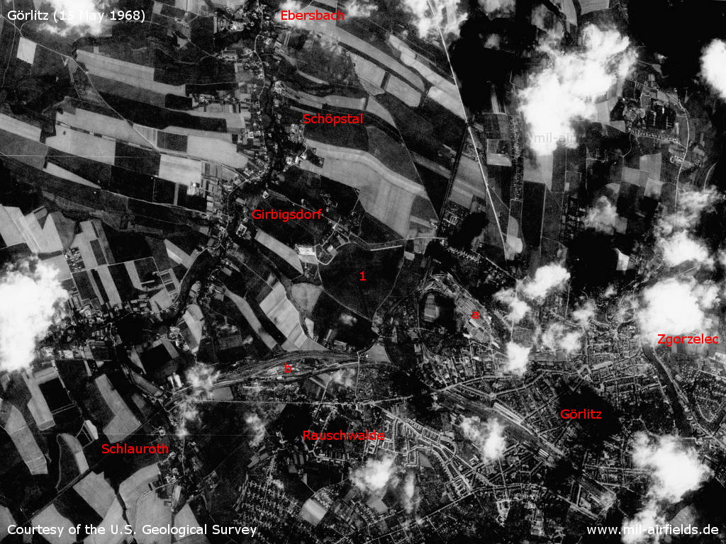
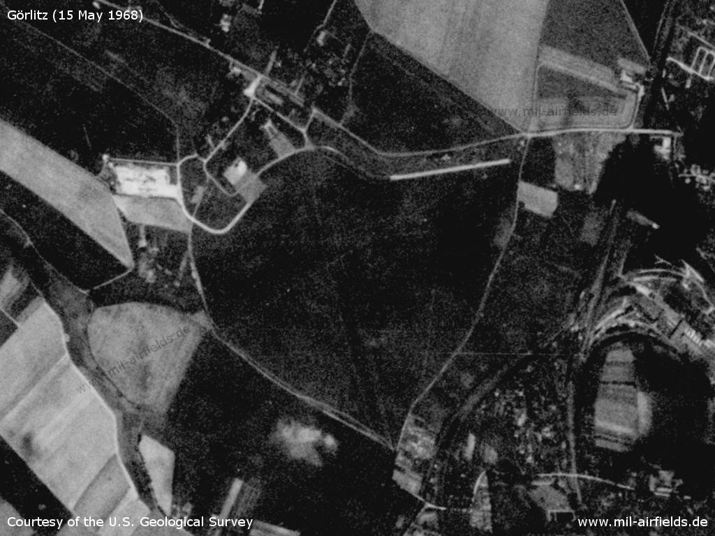
Görlitz and surroundings Airfield on a US satellite image from 15 May 1968 - 1: airfield. Other installations: a: VEB Waggonbau Görlitz; b: Reichsbahnausbesserungswerk RAW Schlauroth. Places: Ebersbach, Girbigsdorf, Görlitz, Rauschwalde, Schlauroth, Schöpstal, Zgorzelec (Polen).
Source: U.S. Geological Survey
Görlitz airfield
Source: U.S. Geological Survey
In the 1970s
Situation
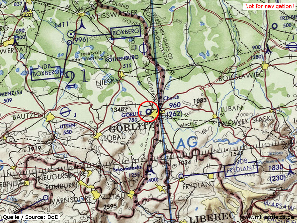
Görlitz Airfield on a map of the US Department of Defense from 1972
Source: ONC E-2 (1972), Perry-Castañeda Library Map Collection, University of Texas at Austin
Overview
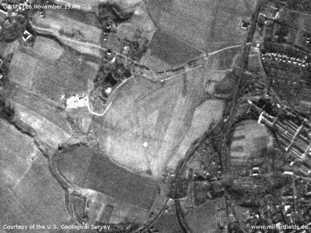
Thursday 26 November 1970 - The bright point in the south of the airfield can also be seen on the 1975 picture. Later aerial photos show that there must have been a plate on the ground.
Source: U.S. Geological Survey
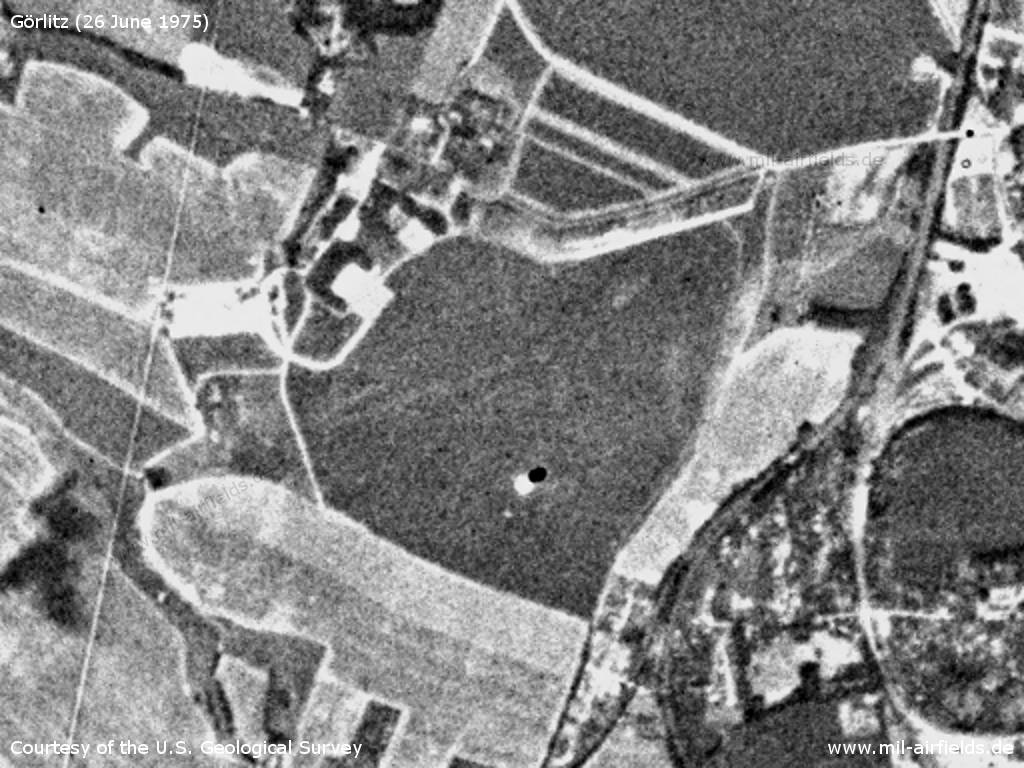
Görlitz airfield on Thursday 26 June 1975 - Also here the plate in the south of the airfield shows up as a bright point.
Source: U.S. Geological Survey
Airspace and procedures
Das VFR-Handbuch Agrarflug von 1977 (NfD) macht für Görlitz folgende Angaben:
- Motorflugbetrieb mit maximal zulässiger Belastung 5500 kp AUW (Gesamtfluggewicht)
- Segelflugbetrieb
- Fallschirmsprunglandeplatz
- Motorflugbetrieb mit maximal zulässiger Belastung 5500 kp AUW (Gesamtfluggewicht)
- Segelflugbetrieb
- Fallschirmsprunglandeplatz
In the 1980s and early 1990s
Use
- Helipad 3037 for Supply Depot 14 (Versorgungslager 14, VL-14) of former East German Air Force (NVA LSK/LV).
- Helipad 5705 of former East German Border Troops (Grenztruppen, GT),
Runways, taxiways, aprons
Dimensions: 600 m x 600 m,
main takeoff and landing direction: 330°,
surface: solid grass,
capacity: 1 helicopter (for helipad 3037).
main takeoff and landing direction: 330°,
surface: solid grass,
capacity: 1 helicopter (for helipad 3037).
Telephone
Sondernetz/Stabsnetz S1 3734-761-829p (VL-14)
Airspace and procedures
Helipad usable at day during good weather conditions
Alert time: 60 minutes.
Alert time: 60 minutes.
Obstacles
None.
Today
Use
General aviation
Links
- http://www.flugplatz-rothenburg-goerlitz.de/ - Flugplatz Rothenburg/Görlitz GmbH Airfield operator; web site includes aerial picture.
Bibliography
- Ries, Karl; Dierich, Wolfgang: "Fliegerhorste und Einsatzhäfen der Luftwaffe" Motorbuch Verlag Stuttgart, 1993 - Allied map
- Grenzdörfer, Joachim; Seifert, Karl-Dieter: "Geschichte der ostdeutschen Verkehrsflughäfen" Bernard & Graefe Verlag, Bonn, 1997 - 4 pages description, maps and aerial picture
Related topics
Airfields in the vicinity
- 339°/22km Hähnichen: Helipad 3038 (HSLP / HLP 3038)
- 360°/23km Rothenburg/Oberlausitz: Air Base (Görlitz)
- 359°/27km Steinbach: Helipad 3051 (HSLP / HLP 3051)
- 277°/30km Bautzen: Air Base (Litten)
Categories
Military Airfields GermanyMilitary Airfields in former East GermanyHelipads of former National People's ArmyHelipads of former National People's ArmyRecommended
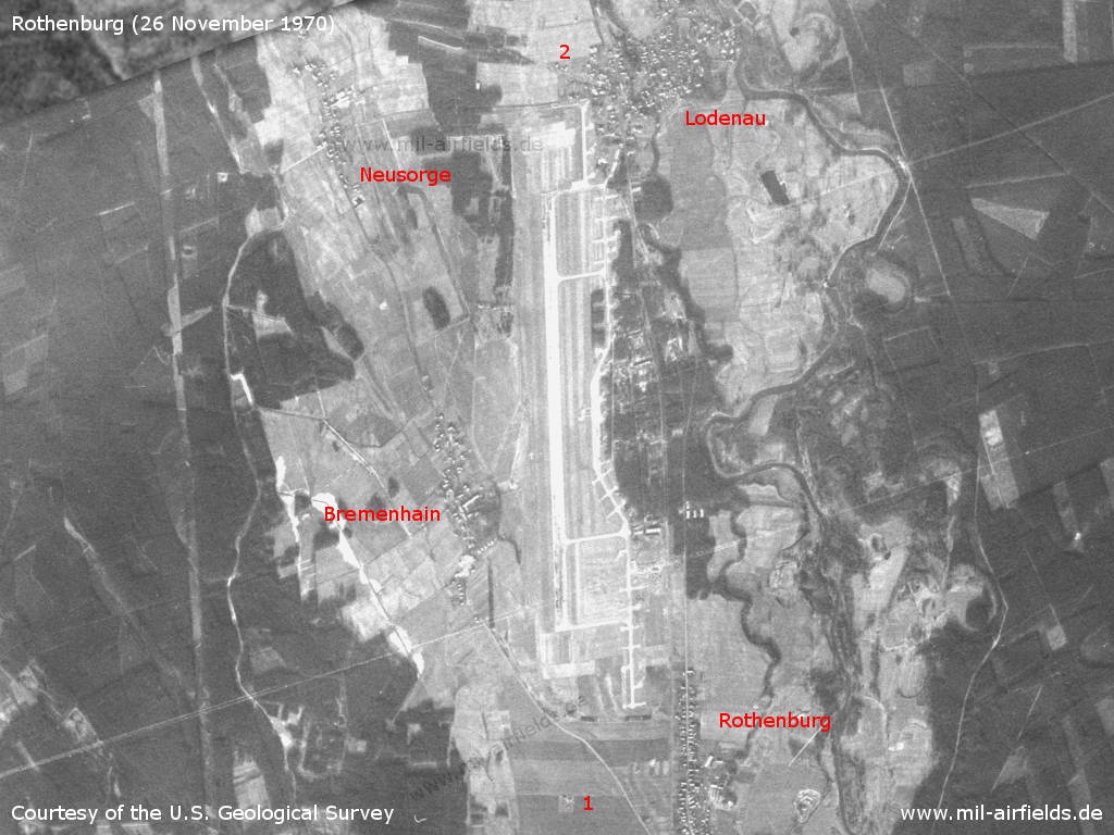
Image credits are shown on the respective target page, click on the preview to open it.
 Follow mil-airfields on Facebook