For historical information only, do not use for navigation or aviation purposes!
| Coordinates | N512339 E0122426 (WGS84) Google Maps |
| Elevation | 430 ft |
| Former East Germany (GDR) | District of Leipzig |
| Federal state | Sachsen (Saxony) |
| Location indicator | EDXL (196x), ETLM (198x) |

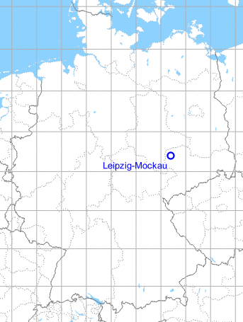
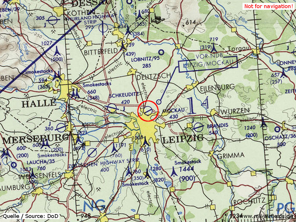
Germany during the Cold War Map
The history of the Cold War airfields: Leipzig-Mockau
General
The Leipzig-Mockau airfield was opened in 1913. Among other things, a large airship hangar was on the area. After World War I, Mockau became the airport for Leipzig, until it was gradually replaced by the newly built Halle/Leipzig Airport in Schkeuditz from 1926 onwards. During the Second World War, Mockau was mainly home of aircraft factories.
In the first years after the World War II, the field was presumably little or not used. From 1949, the commercial air traffic to the Leipzig Fair regularly took place via Mockau Airport. Later, the airport also served in the East German domestic air traffic. The runway was extended for the use of modern airplanes, but this was limited by the situation with the autobahn to the north and the city to the south. For this reason, from the 1960s onwards, the flights to the Leipzig trade fair were transferred to Schkeuditz Airport. In 1972, the domestic traffic also moved to Schkeuditz, after which the field remained the base for agricultural aviation as well as for the premilitary Gesellschaft für Sport und Technik (GST, Society for Sport and Technology). After the political change, the Mockau airfield was used for a short time until it was finally closed in 1991. An industrial and exhibition area has been built here.
Location of airfield
Northern edge of Leipzig, south of Autobahn A14 between intersections AS23 and AS24.
During the 1920s/1930s
Business owner / Administrator
Leipziger Luftschiffhafen- und Flugplatz A. G., Leipzig
Town office: Leipzig, Neumarkt 40
Airport: Leipzig N 21, Dübener Landstraße
Cable: Lefag Leipzig
(1928)
Situation
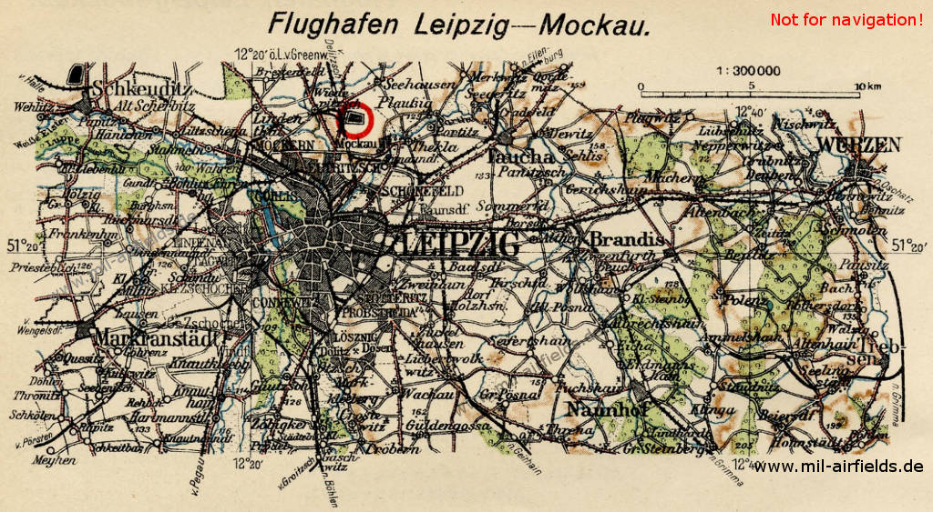
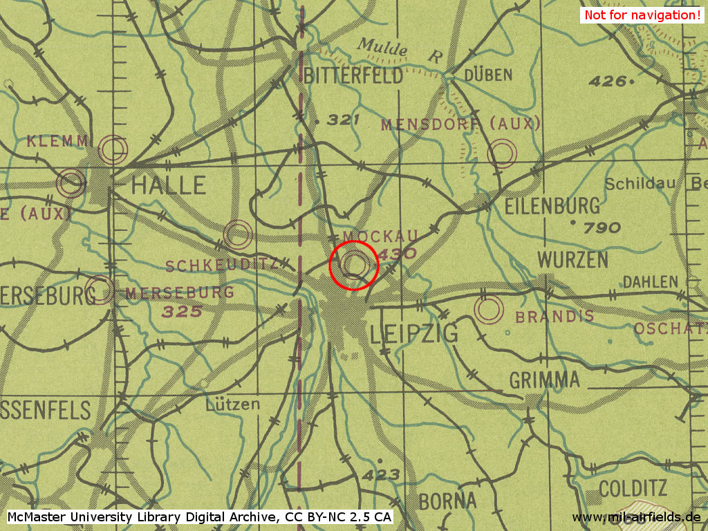
The airports Leipzig Mockau (red circle) and Schkeuditz (top left) on a map from 1928
Overview
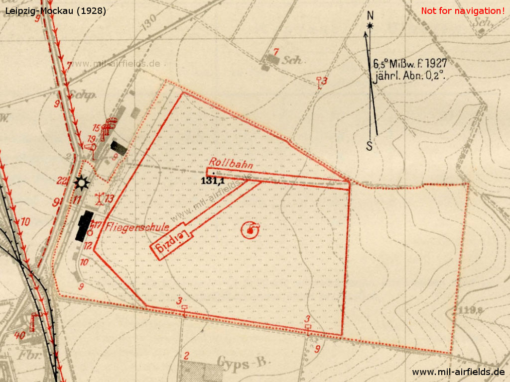
Mockau airport in 1928
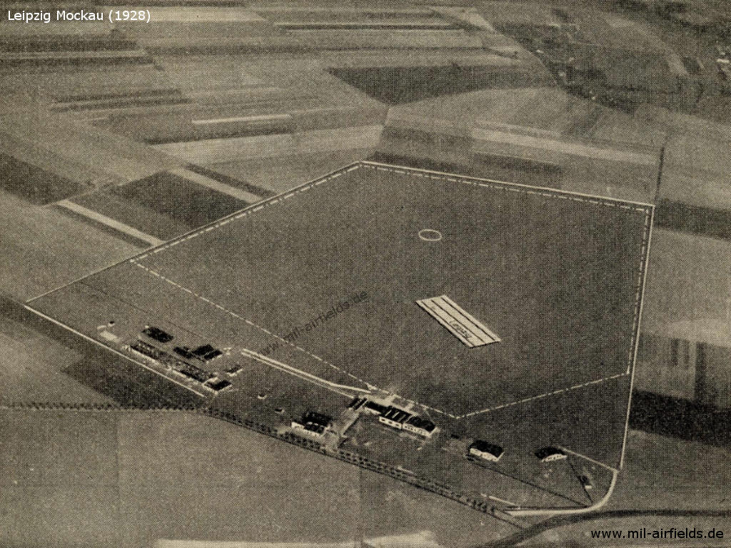
Aerial view, looking east (ca. 1928)
Airfield characteristics at daytime
On the movement area black circle of 50 m diameter with smoke oven. On white cement plate the black inscription "Leipzig". Landing sign is always deployed. Red-white windsack on the factory building north of the airport. Völkerschlacht monument 9 km south of the movement area.
Airfield characteristics at night
Permanent night lighting not available. At the request of the operator and if an airplane is located in the vicinity of the airport: revolving fire of 740 000 HK on the lookout tower of the airport hotel. The fire shows flashing groups of 2 flashes and is turned off as soon as the aircraft is landing. On timely request at the operaor, landing lights from green, white and red fires in line parallel to the wind direction. Land from green over white to red, to the right of the row. In case of emergency landings, fire from torches. Land between two whites towards a red torch.
Runways
Terrain: Good sod on a dry surface.
Shortest rolling length: in north-south direction 700 m.
Shortest rolling length: in north-south direction 700 m.
Airlines
Aero-Expreß-Luftbetrieb G.m.b.H., Leipzig
Nordbayerische Verkehrsflug-G.m.b.H., Leipzig
(1928)
Hangars
Hangar I: 30.0 x 18.5 m,
hangar II: 40.0 x 30.0 m.
In each hangar is a running crane with a load capacity of 1.5 t each.
hangar II: 40.0 x 30.0 m.
In each hangar is a running crane with a load capacity of 1.5 t each.
Workshops
Spare parts for all German engine types in stock.
Fuel equipment
For 20,000 l gasoline and benzene. Always 5000 l Shell gasoline and 4000 l Dapolin in stock.
Railway siding
1 front and 3 side ramps.
First aid in the case of accidents
Medical room available. Nearest doctor in the St. Georg hospital (1 km distance).
Customs, post office, passport
Post office with telephone available. Passport inspection by police station.
Accommodation of passengers
In the airport hotel.
Connections
Taxi cabs on call.
Electric tram nearby.
Electric tram nearby.
Images
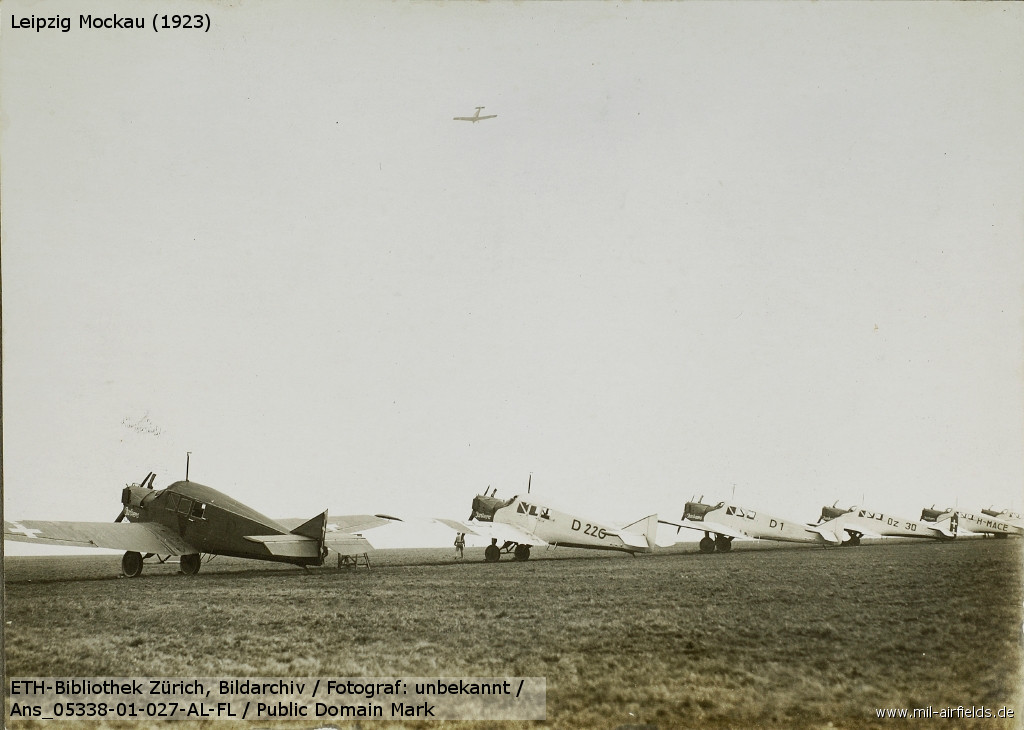
Original title "Arrival in Leipzig" (1923)
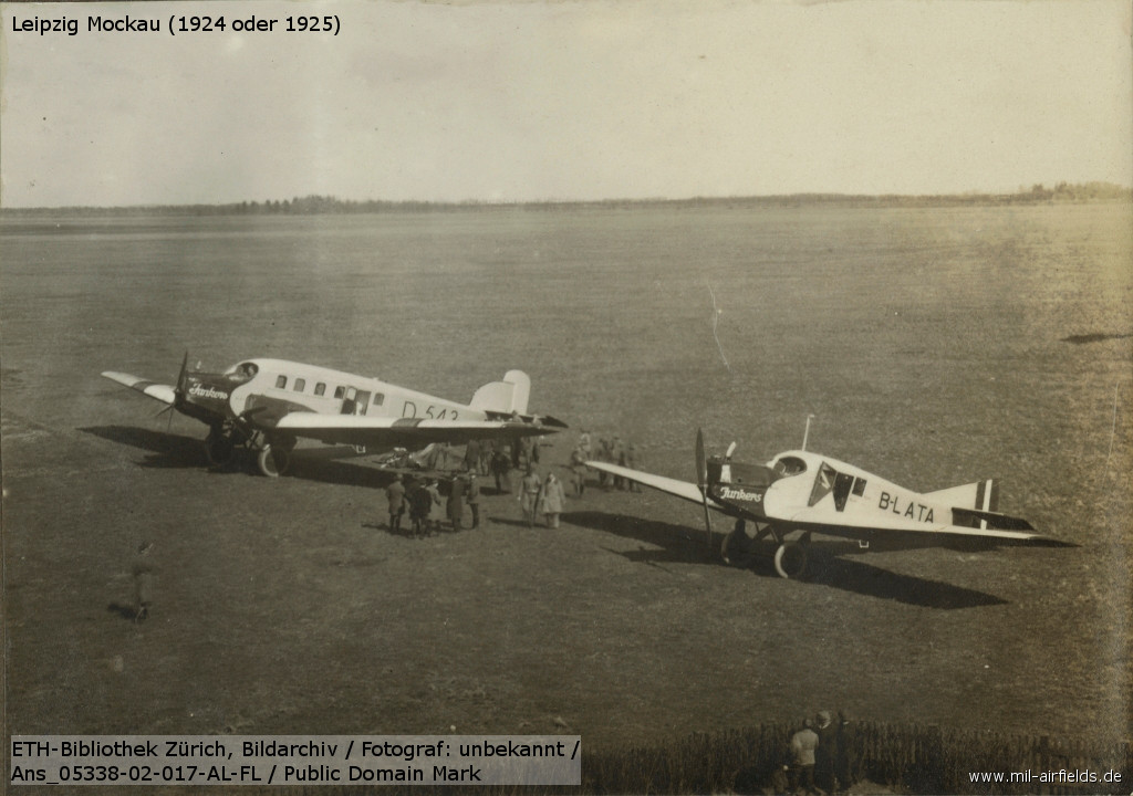
Junkers G 23 "Baden" D 543 before the direct flight Leipzig/Mockau-Copenhagen in March 1924
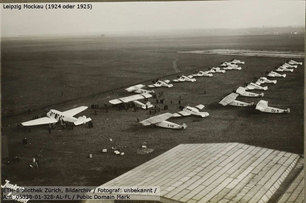
Airplanes for the Leipzig Trade Fair (1925)
During World War II
Situation
Leipzig Mockau on a US map from 1944
Source: McMaster University Library Digital Archive, License: Creative Commons Attribution-NonCommercial 2.5 CC BY-NC 2.5 CA
Overview
Leipzig Mockau airfield on a US map from 195x - Well recognizable on the map are the limited possibilities for expanding the airfield: in the north runs the Autobahn, to the south is the city
Source: AMS M841 GSGS 4414, Courtesy Harold B. Lee Library, Brigham Young University
During the Cold War
Use
Civil airport for Leipzig, later base for agricultural aviation and for the former East German paramilitary organization Gesellschaft für Sport und Technik (GST).
In the 1940s
History
CIA report about June and July 1949
29 June 1949 German civilian workers of a construction firm did repair work at the southwestern section of the LEIPZIG-MOCKAU (N 52/E 32) airfield. Three 13x13 feet holes, about five feet deep, had been dug and pipe sections, 75 mm in diameter, were lying nearby. An empty train of 50 open boxcars was standing on the railroad spur track. The field was guarded by German "People's Police".
05 July 1949 The LEIPZIG-MOCKAU airfield, though unoccupied, was guared by German "People's Police". ... and a ... entered the field to load empty gasoline barrels.
20 July 1949 The LEIPZIG-MOCKAU airfield was not occupied by soldiers or aircraft. The runway was intact and the landing field covered with high grass. All buildings except the flight control station, the headquarters building and one hangar were destroyed. German workers were doing construction work.
Comment Report shows that the LEIPZIG-MOCKAU airfield is not occupied by an air unit. From the construction work observed at the field it is inferred that the airfield is intended to be re-occupied. The reported motor vehicle ... to the air transport regiment, stationed in ALTENBURG.
Source: /CIA RDP82-00457R003200660017-3/
CIA report about August 1949
16 August 1949 The LEIPZIG-MOCKAU (N 52/E 21) airfield was not occupied by Soviet military units. About 30 German workers were busy filling holes and craters at the airfield.
16 to 18 August 1949 The LEIPZIG-MOCKAU airfield was unoccupied and unused. All airfield installations, except for the former airport restaurant, which had been newly furnished, were destroyed. A long freight train was standing on the field spur track. A German police detail was observed in a cantonment building at the edge of the field. The landing field was serviceable. Boundary and obstacle lights were not seen.
18 August 1949 The LEIPZIG-MOCKAU airfield was not occupied by the Soviets. Twelve to 15 German workers were engaged in clearing work. The airfield buildings were demolished. No technical installations were observed.
Comment Three independent sources are in accord in stating that the LEIPZIG-MOCKAU airfield is not occupied by an air unit. According to this report - which is considered credible - the occupation of the field has not changed since 20 July 1949. The statement that the airport restaurant was newly furnished was corroborated by a press report, according to which the LEIPZIG-MOCKAU airfield was scheduled to be used by commercial aircraft during the LEIPZIG Autumn fair.
Source: /CIA RDP82-00457R003400290001-6/
CIA report about August 1949
The LEIPZIG-MOCKAU (N 52/E 21) airfield was unoocupied from 16 to 18 August 1949. The airfield administration building and some other brick and wooden buildings located on the western border of the field were intact. A police detail of about ten men was quartered in one of these buildings. Empty freight cars were standing on the spur track. The fuel tank installations at the southwestern corner of the landing field were demolished.
Comment: Report confirmed the observations made by ... during the same period.
Source: /CIA RDP82-00457R003400380010-6/
CIA report about September 1949
20 September 1949 No Soviet aircraft were observed to be stationed at the LEIPZIG-MOCKAU (N 52/E 21) airfield. A few German workers were engaged in leveling work. Some obstacle lights in the airfield vicinity were burning at night.
Comment The statement that no aircraft were stationed at the airfield is in accordance with previous information. The indications are that the field will not be occupied by an air unit in the near future.
Source: /CIA RDP82-00457R003900480008-3/
CIA report about September 1949
1. On 29 September 1949, Mockau airfield (E21) was not occupied by Soviet Air Force units. Local residents stated that the last planes seen were transports, which arrived during the last Leipzig Fair period. The field was not guarded on observation date.
2. Mockau airfield lies just north of Leipzig between the rail line Mockau-Delitzsch and the Autobahn. Its flight strip is concrete and measures 1,000 x 40 meters. There are also taxi strips. The remainder of the field is covered with short grass and was not damaged by wartime bombings. It is suitable for immediate use by all types of planes, including jets.
3. All main buildings and technical installations were destroyed, and the field does not have hangars, fuel storage, or night lights.
Source: /CIA RDP82-00457R003700210002-0/
CIA report about Oktober 1949
12 October 1949 The LEIPZIG-MOCKAU (N 52/E 21) airfield was not occupied by the Soviet Air Force.
17 October 1949 The field was unoccupied but guarded. The runway and taxiways were serviceable. No work was observed.
17 October 1949 Not occupied by Soviet Air Force troops. Several warning plates had been erected along the edge of the field. A German "People's Police" guard was quartered on the western edge. All hangars were destroyed. There were red obstacle lights around the airfield.
Comment Report confirms that the airfield is not occupied by an air unit. The condition of the field has apparently not changed since 20 September 1949. The landing field is intact.
Source: /CIA RDP82-00457R004100180008-3/
CIA report about November 1949
09 November 1949 The LEIPZIG-MOCKAU (N 52/E 21) airfield was serviceable but not occupied by the Soviet Air Force.
16 November 1949 The field was not occupied by aircraft or Soviet Air Force personnel. It was guared by German "People's Police" patrols. Warning signs were erected along the edge of the field. The wrecks of gutted railroad cars were standing on the spur track. No construction work was under way. The red obstacle lights in the field environs were turned on at night.
Comment The occupation and condition of the field have not changed since last observations dated October 1949. No air force unit is stationed at the field.
Source: /CIA RDP82-00457R004100550012-7/
1950s
Runways
- 06/24: 1200 m x 50/76 m
Radio beacons
- LOM 25: 335 "BR", 4018 m to threshold 25
- LMM 25: 355 "B", 980 m to threshold 25
Obstacles
In the west airport buildings 25 m,
2 km 240° chimney 45 m,
3.5 km 200 ° chimney,
2 km 205 ° chimney 30 m,
in take-off direction 243°: large railway bridge
2 km 240° chimney 45 m,
3.5 km 200 ° chimney,
2 km 205 ° chimney 30 m,
in take-off direction 243°: large railway bridge
Images
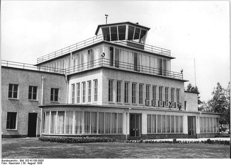
The terminal building on 30 August 1956
Source: Bundesarchiv, Bild 183-41100-0005, Zentralbild Naumann / CC BY-SA 3.0, via Wikimedia Commons
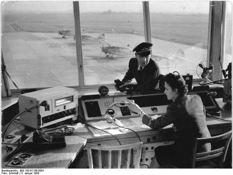
The control tower on 03 January 1959
Source: Bundesarchiv, Bild 183-61199-0001, Zentralbild Schmidt / CC BY-SA 3.0, via Wikimedia Commons
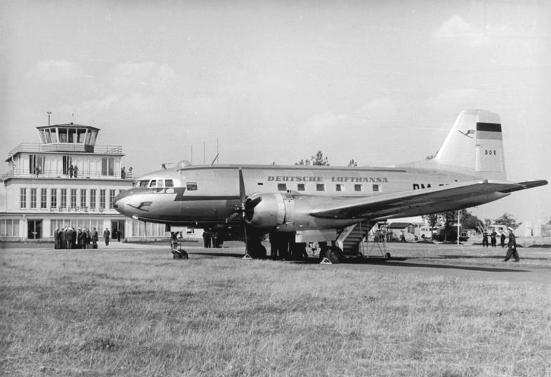
An Ilyushin Il-14 of the East German Deutsche Lufthansa der DDR on 30 August 1956
Source: Bundesarchiv, Bild 183-41100-0006, Zentralbild Neumann / CC BY-SA 3.0, via Wikimedia Commons
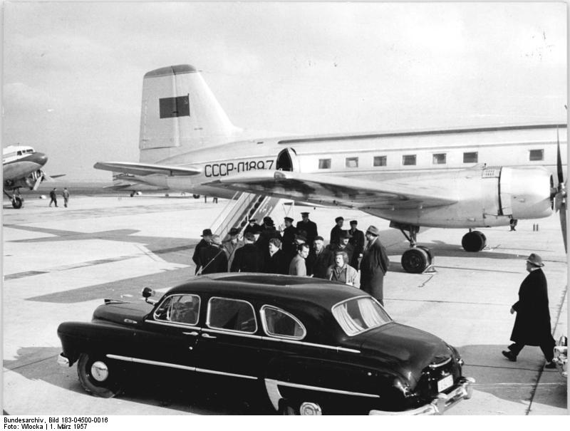
Il-14 of the Soviet Aeroflot in Mockau on 01 March 1957 - It could be the СССР-Л1897 or СССР-Л1887
Source: Bundesarchiv, Bild 183-04500-0016 / CC BY-SA 3.0, via Wikimedia Commons
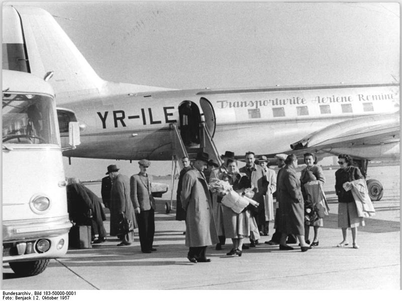
Ilyushin Il-14 YR-ILE of the Romanian Airlines on 02 October 1957
Source: Bundesarchiv, Bild 183-50000-0001, Zentralbild Benjach / CC BY-SA 3.0, via Wikimedia Commons
1960s
Use
Leipzig airport.
Operator: Interflug, Betriebsteil Flughäfen, Flughafen Leipzig
At this time, East German airports had location indicators from the series EDX..., Leipzig-Mockau had EDXL.
Overview
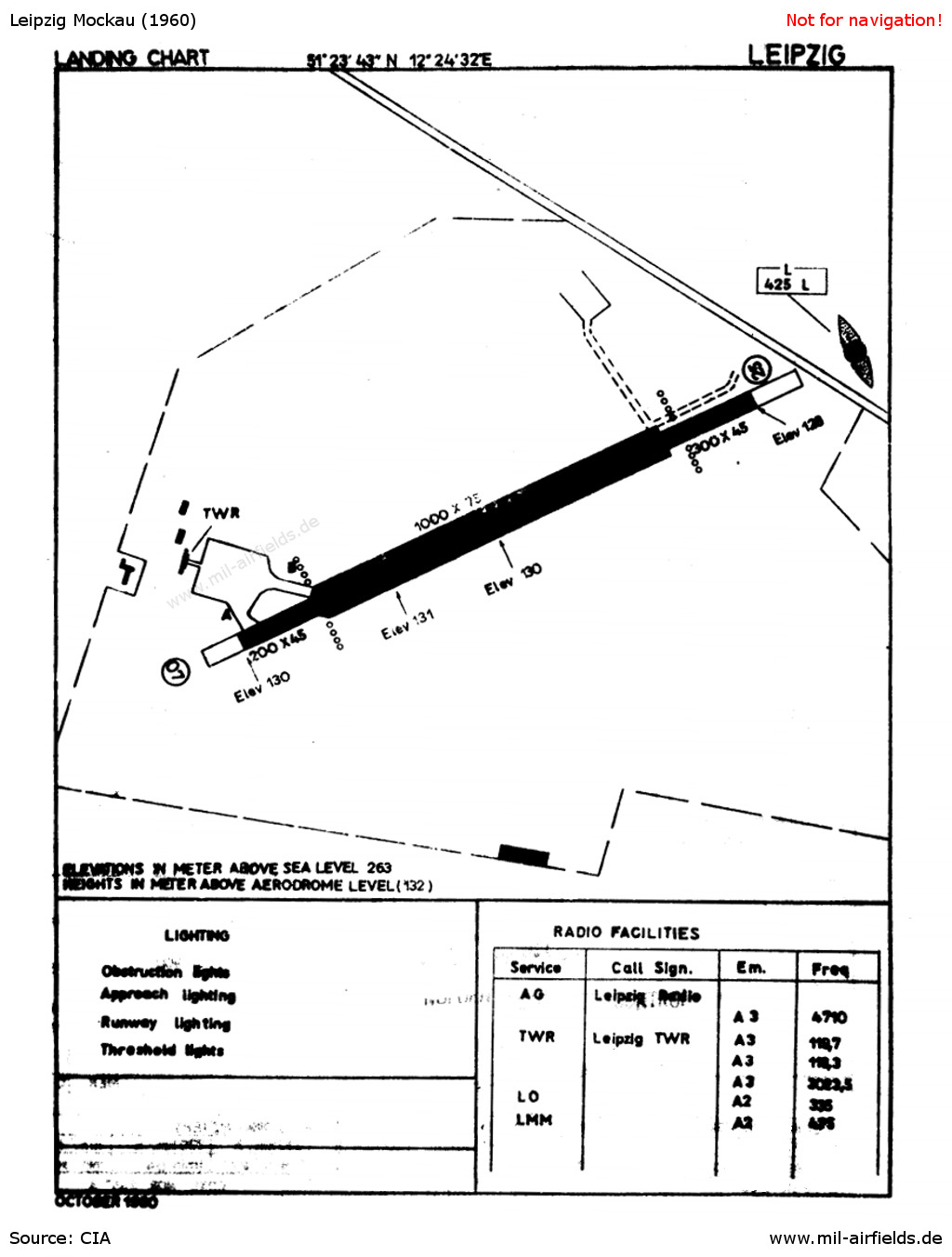
Chart of Leipzig Mockau Airport from 1960
Source: CIA
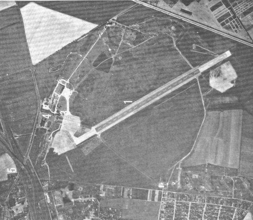
Aerial picture from the 1960s or 70s - Aerial picture from east german field manual "A 042/1/003 Auswertung von Luftbildern" from 1973.
1 - Runway; 2 - Hangar with apron; 3 - Gate and control tower; 4 - Terminal.
On the apron, 3 larger aircrafts are visible, maybe Il-14s. Two smaller aircrafts are standing in front of the hangar.
Runways
- 07/25: 1500 m x 45/75/45 m Concrete
Radio beacons
- LOM 25: 335 "LG", 3,89 km to threshold 25
- LMM 25: 425 "L", 0,91 km to threshold 25
- LMM 07: 425 "G", 1,90 km to threshold 07
- KGSP 25: 110.3
Radio communication
- Leipzig Tower 3023.5 (HF), 124.7, 119.7
Telephone
Leipzig 50166, 52648, 52649
Teletype
051349 INTERFLUG LZG
Weather station
The meteorological station at the airport had the ID 10470.
History
- May 7, 1966
At around 17:05, a GST L-60 crashed over the airfield. The aircraft was carrying 3 parachutists and the pilot. The 2nd skydiver got caught in the tail unit, but was able to free himself. He was injured and taken to hospital. The 3rd skydiver made an emergency jump and was uninjured. The aircraft crashed from about 500 m near the Interflug runway, killing the pilot. - July 20, 1969
At around 12:20 p.m., a balloon broke loose at the Mockau airfield during the inflation process. It was flying in an east/southeast direction without a guide gondola. The balloon has a diameter of approx. 15 m and bears the inscription "SP-Kattowice". The valve could still be opened. It is estimated that the balloon can fly approx. 10 to 15 km. Just over an hour later, the balloon is found in a sand pit near Ammelshain.
In the 1970s
Situation
Leipzig Mockau airport on a map of the US Department of Defense from 1972 - This year, the remaining air traffic was relocated from Leipzig Mockau to Schkeuditz.
Overview
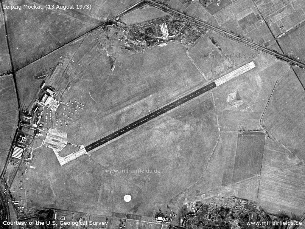
Satellite image from 13 August 1973
Source: U.S. Geological Survey
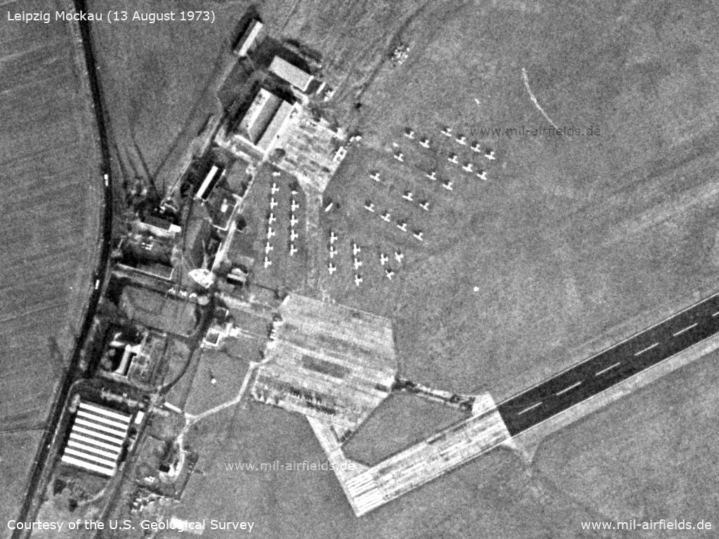
Apron - There are about 40 aircraft here, presumably agricultural aircraft. On the northern apron is an An-2.
Source: U.S. Geological Survey
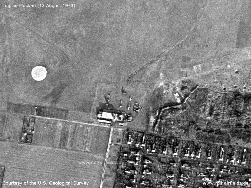
Southern part - Here are also airplanes, presumably of the East German pre-military Gesellschaft für Sport und Technik (Society for Sport and Technology) Here are also aircraft, presumably of the pre-military "Society for Sport and Technology". A jump circle can be seen on the left. The terrain on the right has numerous craters.
Source: U.S. Geological Survey
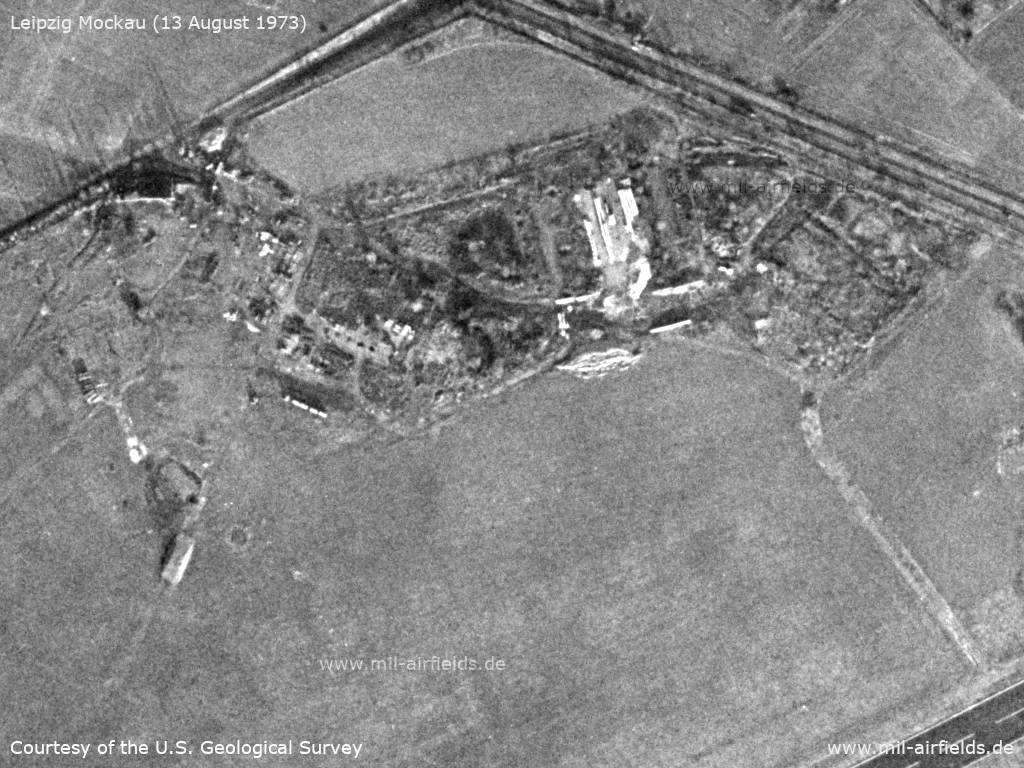
Rubble site near the highway
Source: U.S. Geological Survey
History
- January 31, 1972
At 13:20, an exercise begins at the airfield under the code word "Emergency". - June 4, 1972
A GST Jak-18 aircraft is missing. The aircraft with the registration DM-WFW had taken off from Riesa at 13:12 to fly on the route Sachsdorf - Mockrehna - Hoburg - Wurzen - Taucha to Leipzig-Mockau and land there at 13:50. The plane finally landed in Mockau at 14:57. - 1976
A new building is erected at the airfield for agricultural flight training. - May 29, 1979
At 11:55 a.m., the pilot of an agricultural aircraft flying from Mockau alerted the People's Police. He had flown over the Aulig work airfield (Borna district) at 11:35 a.m. and noticed light signals on a Z-37 DM-SLQ. It was suspected that unauthorized persons were tampering with it. Forces from the Borna district police office and the Stasi district office then go to the site. At around 12:25 p.m., the aircraft in question was spotted in flight. It turned out to be an uncoordinated Interflug exercise involving a terrorist attack on an agricultural aircraft. The pilot of the aircraft flying over the working airfield was informed of the attack by radio and therefore reported it to the People's Police on his return to Mockau.
Sources: Bundesarchiv
In the 1980s and early 1990s
Use
The airfield is used by the East German airline Interflug, Agricultural Aviation department, for agricultural aviation training.
On the airfield are located:
- Management of the southern branch of the agrarian aviation
- Management of the agricultural flight squadrons of the districts Leipzig and Gera
- Works academy "Arthur Pieck"
- Repair facility for Zlin Z-37 Čmelák aircraft and Kamov Ka-26 helicopters
- Main department for material-technical supply
- Central warehouse
The field is also used by the pre-military organization Gesellschaft für Sport und Technik (GST).
Overview
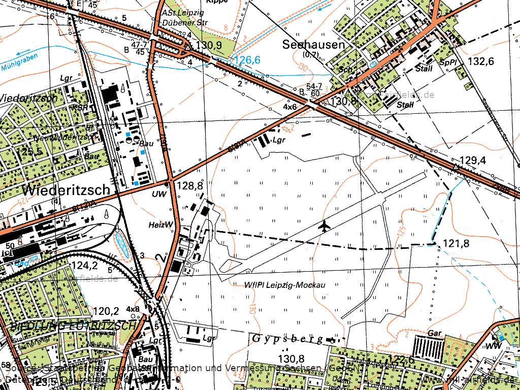
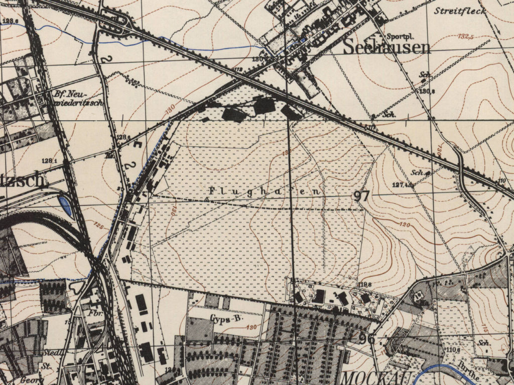
Topographic map East Germany 1985 - The airfield is designated as a working airfield (WflPl = Wirtschaftsflugplatz). The GDR autobahn A10 (today A14) runs in the northeast. Places nearby: Neuwiederitzsch station (today Leipzig Messe station), Wiederitzsch, Seehausen. The whole map was classified as "Secret" (Vertrauliche Verschlußsache VVS)
Source: Staatsbetrieb Geobasisinformation und Vermessung Sachsen (GeoSN), Datenlizenz Deutschland – Namensnennung – Version 2.0 (dl-de/by-2-0), http://www.govdata.de/dl-de/by-2-0
Runways
- 07/25: 1500 m x 45 m Concrete
- 07/25: 1000 m x 200 m Grass
- 07/25: 1000 m x 200 m Grass
(Direction, runway length x width, surface)
Das Protokoll des Nationalen Verteidigungsrates vom 11.11.1985 nennt für den Flugplatz Leipzig-Mockau einen Bedarf zur Rekonstruktion der gesamten Flugbetriebsflächen. Die Kosten werden mit ca. 25 Mio M angegeben, ein Termin ist nicht festgelegt. (Quelle: Bundesarchiv)
Telephone
Interflug Betrieb Agrarflug: 0941/55191, Fluggespräche: 52605, Abt. Materialwirtschaft: 52867
Teletype
Interflug Betrieb Agrarflug: 051349, 051363 IFLM DD
Connections between visual approach and departure routes and local flying routes
Anschlussstrecken zu den örtlichen Fluglinien (1982)
Leipzig-Mockau, Kreuma, Delitzsch, Brehna, Autobahn bis nach der örtlichen Fluglinie 25 (Streckenabschnitt Gerbstedt-Bad Düben)
Leipzig-Mockau, Autobahnabfahrt Taucha, Wurzen, kürzester Flugweg nach der örtlichen Fluglinie Nr. 34 (Streckenabschnitt Mockrehna-Mutzschen)
Leipzig-Mockau, Autobahnabfahrt Taucha, Holzhausen, Markkleeberg, Eythra, Lucka auf der örtlichen Fluglinie Nr. 42 (Streckenabschnitt Kitzscher-Zeitz)
Leipzig-Mockau, Autobahnabfahrt Taucha, Holzhausen, Markkleeberg, Eythra, Laucha, kürzester Flugweg nach der örtlichen Fluglinie Nr. 12 (Streckenabschnitt Schraplau-Jena)
Standard training routes
Flugstrecken für Ausbildungsflüge der Abteilung Fliegerische Aus- und Weiterbildung, Staffel Agrarflug (der Interflug) (1982)
1. Leipzig-Mockau - Rackwitz 81/18b - Försterei Wellaune 79/19d - Wassermühle Gröbern 78/19c - Försterei Schleesen 77/19b - Österritz (Meuro) 78/20b - Försterei Trossin 79/21b - Försterei Gräfendorf (Wildenhain) 80/21b - Bhf. Dornreichenbach 82/21b- Rackwitz 81/18b - Leipzig-Mockau. Flughöhe: 50 m AGL.
2. Leipzig-Mockau - Rackwitz 81/18b - Wassermühle Burgkemnitz 78/18c - Wassermühle Reinharz 78/20b - Försterei Steinsdorf (Schweinitz) 77/23a - Plossig 78/22d - Ausbau Süptitz 79/22c - Försterei Battaune 80/20b - Rackwitz 81/18b - Leipzig-Mockau. Flughöhe: 50 m AGL.
3. Leipzig-Mockau - Rackwitz 81/18b - Försterei Tornau 79/20a - Försterei Naderkau (Schlessen) 77/19a - Wassermühle Ateritz 77/20c - Försterei Tornau 79/20a - Merschwitz (Elbe) 78/21a - Försterei Roitzsch 79/21c - Rackwitz 81/18b - Leipzig-Mockau. Flughöhe: 50 m AGL.
4. Leipzig-Mockau - Rackwitz 81/18b - Roitzschora 79/19c - Försterei Schköna 78/19c - Försterei Arnsdorf 77/22b - Sachau (Elbe) 78/21d - Vogelsang (Elbe) 79/22a - Försterei Wermsdorf 83/22b - Wassermühle Thallwitz 81/20b - Krensitz 80/19c - Leipzig-Mockau. Flughöhe: 50 m AGL.
History
- May 2, 1986
At 17:54, a PZL Bielsko SZD-45 Ogar No. 3513 motor glider belonging to the Gesellschaft für Sport und Technik (GST) crashed approx. 2 km southwest of the airfield. During aerobatics, both wings broke off after the 2nd loop. The pilot was killed in the crash.
Today: A lost place in Leipzig
Use
Airfield is closed. The area is used as commercial area. Some old buildings can still be found, especially the terminal building with the tower.
Address
Am alten Flughafen / Graf-Zeppelin-Ring 15
04356 Leipzig
04356 Leipzig
Videos
- https://youtu.be/vMSaq6JBz8A - 31.Mai.1991 Letzter Flugtag in Leipzig Mockau (31 May 1991: Last flight day at Leipzig Mockau)
Links
- https://de.wikipedia.org/wiki/Flughafen_Leipzig-Mo... - Wikipedia about the Leipzig Mockau airport
Bibliography
- Ries, Karl; Dierich, Wolfgang: "Fliegerhorste und Einsatzhäfen der Luftwaffe" Motorbuch Verlag Stuttgart, 1993 - Allied map of Mockau
- Michels, Jürgen; Werner, Jochen: "Luftfahrt Ost 1945-1990" Bernard & Graefe Verlag, Bonn, 1994 - Short description
- Grenzdörfer, Joachim; Seifert, Karl-Dieter: "Geschichte der ostdeutschen Verkehrsflughäfen" Bernard & Graefe Verlag, Bonn, 1997 - Description of history since 1912, pictures, maps.
- Freundt, Lutz: "Sowjetische Fliegerkräfte in Deutschland 1945-1994, Band 2" Freundt Eigenverlag, Diepholz 1999 - Short description of post-war history; aerial photo from 1953.
Related topics
Airfields in the vicinity
Categories
Military Airfields GermanyAgricultural Airfields in former East GermanyMilitary Airfields in former East GermanyRecommended

Image credits are shown on the respective target page, click on the preview to open it.
 Follow mil-airfields on Facebook