Slovakia: Air Bases and Military Airfields
For historical information only, do not use for navigation or aviation purposes!
Until 1992, the territory of today's Slovakia was part of Czechoslovakia (Československo).
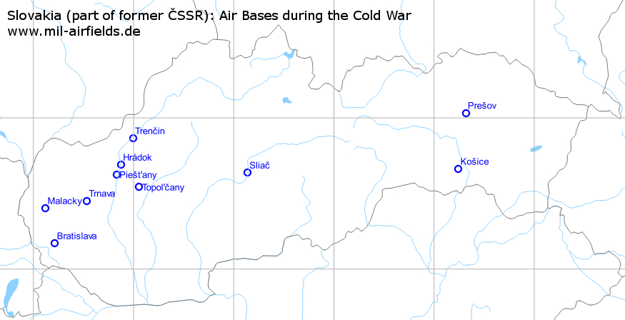
Military airfields in Slovakia (11)
| Bratislava: Airport |
| Hrádok: Highway Strip |
| Košice: Air Base |
| Malacky: Airfield |
| Malacky: Firing Range |
| Piešt'any: Airfield |
| Prešov: Airfield |
| Sliač: Airfield |
| Topol'čany: Airfield |
| Trenčin: Airfield |
| Trnava: Airfield |
Bratislava: Airport
Ivanka, Letisko M.R.Štefánika
For historical information only, do not use for navigation or aviation purposes!
| Coordinates | N481012 E0171246 (WGS84) Google Maps |
| Elevation | 436 ft |
| Location indicator | LKIB, LZIB |
Runways
- 04/22: 2900 m x 60 m Concrete
- 13/31: 3190 m x 45 m Concrete
Radio communication
According to western signals intelligence (SIGINT), the airfield was also called "Navigacni Punkt 780" by the Czechoslovak Air Force.
Airfields in the vicinity
- 345°/27km Malacky: Airfield (Kuchyňa)
- 232°/32km Parndorf: Air Base (Аэродром Парндорф)
- 037°/39km Trnava: Airfield (Boleraz)
Hrádok: Highway Strip
For historical information only, do not use for navigation or aviation purposes!
| Coordinates | N484126 E0175221 (WGS84) Google Maps |
Runways
- 18/36: ca. 3200 m
Airfields in the vicinity
- 204°/8km Piešt'any: Airfield (Piestany, Letisko Piešťany)
- 024°/21km Trenčin: Airfield (Letisko Trenčín, Trencin)
- 141°/21km Topol'čany: Airfield (Topolcany)
- 224°/37km Trnava: Airfield (Boleraz)
Categories
Highway Strips WorldwideKošice: Air Base
Kosice, Barca
For historical information only, do not use for navigation or aviation purposes!
| Coordinates | N483947 E0211428 (WGS84) Google Maps |
| Elevation | 755 ft |
| Location indicator | LZKZ |
Location of airfield
6 km south of Košice.
Use today
Regional airport.
Runways
- 01/19: 3100 m x 45 m Asphalt
- 01/19: 1000 m x 60 m Grass
Radio communication
The call sign of the airfield was "KOLEKCE" (1990).
According to western signals intelligence (SIGINT), the airfield was also called "Navigacni Punkt 960" by the Czechoslovak Air Force.
Units
2 LSP: L-29, L-39C/V (1990)
Malacky: Airfield
Kuchyňa
For historical information only, do not use for navigation or aviation purposes!
| Coordinates | N482411 E0170708 (WGS84) Google Maps |
| Elevation | 679 ft |
| Location indicator | LKMC, LZMC |
Location of airfield
8 km southeast of Malacky.
Runways
- 02/20: 2487 m x 56 m Concrete
Radio communication
The call sign of the airfield was "RUDOKOP" (1990).
According to western signals intelligence (SIGINT), the airfield was also called "Navigacni Punkt 700" by the Czechoslovak Air Force.
Units
Target towing: L-39V (1990).
Airfields in the vicinity
- 165°/27km Bratislava: Airport (Ivanka, Letisko M.R.Štefánika)
- 080°/31km Trnava: Airfield (Boleraz)
- 253°/39km Strasshof: Airfield (Deutsch-Wagram)
Malacky: Firing Range
For historical information only, do not use for navigation or aviation purposes!
Usage during the Cold War
Former air-ground training area for Czechoslovak Air Force.
Radio communication
The radio call sign was "ERABURA" (1990)
Piešt'any: Airfield
Piestany, Letisko Piešťany
For historical information only, do not use for navigation or aviation purposes!
| Coordinates | N483733 E0174944 (WGS84) Google Maps |
| Elevation | 545 ft |
| Location indicator | LKPP, LZPP |
Use today
Airport; Military museum.
Runways
- 01/19: 2000 m x 30 m Asphalt/Concrete
- 01/19: 1400 m x 50 m Grass
Radio communication
The call sign of the airfield was "CITRON" (1990).
According to western signals intelligence (SIGINT), the airfield was also called "Navigacni Punkt 740" by the Czechoslovak Air Force.
Units
3 LSP: L-29, L-39C, ZA, L-410M, Mi-2, Mi-17 (1990).
Airfields in the vicinity
- 024°/8km Hrádok: Highway Strip
- 119°/19km Topol'čany: Airfield (Topolcany)
- 024°/29km Trenčin: Airfield (Letisko Trenčín, Trencin)
- 229°/29km Trnava: Airfield (Boleraz)
Prešov: Airfield
Presov
For historical information only, do not use for navigation or aviation purposes!
| Coordinates | N490150 E0211850 (WGS84) Google Maps |
| Location indicator | LKPW, LZPW |
Location of airfield
6 km northeast of Prešov.
Usage during the Cold War
Reserve airfield.
Use today
Military helicopter base.
Sliač: Airfield
Letisko Sliač, Sliac, Zvolen, Tri Duby, Зволен
For historical information only, do not use for navigation or aviation purposes!
| Coordinates | N483818 E0190804 (WGS84) Google Maps |
| Elevation | 1043 ft |
| Location indicator | LKSL, LZSL |
Location
2 km north of Sliač, 7km north of Zvolen.
Runways
Data for the year 1990:
- 18/36: 2340 m x 60 m Concrete
- 18/36: 1000 m x 100 m Grass
Radio beacons
Data for the year 1990:
- LOM: 412 "FS"
- LMM: 843 "F"
Radio communication
The call sign of the airfield was "FIKUS" ("ФИКУС") (1990).
According to western signals intelligence (SIGINT), the airfield was also called "Navigacni Punkt 880" by the Czechoslovak Air Force.
Units
Soviet helicopter unit OBVP Mi-8, Mi-24; departed 10/1990.
Topol'čany: Airfield
Topolcany
For historical information only, do not use for navigation or aviation purposes!
| Coordinates | N483236 E0180316 (WGS84) Google Maps |
Location of airfield
8 km west-southwest of Topol'čany.
Usage during the Cold War
Reserve airfield.
Runways
- 02/20: 2500 m Grass
Airfields in the vicinity
- 299°/19km Piešt'any: Airfield (Piestany, Letisko Piešťany)
- 321°/21km Hrádok: Highway Strip
- 353°/36km Trenčin: Airfield (Letisko Trenčín, Trencin)
- 255°/40km Trnava: Airfield (Boleraz)
Trenčin: Airfield
Letisko Trenčín, Trencin
For historical information only, do not use for navigation or aviation purposes!
| Coordinates | N485151 E0175932 (WGS84) Google Maps |
| Elevation | 676 ft |
| Location indicator | LKTN, LZTN |
Location of airfield
4 km southwest of Trenčin.
Usage during the Cold War
Maintenance of aircraft types L-29, L-39, L-410, MiG-23, Su-22, Su-25 (1990).
Use today
Airfield, aircraft maintenance.
Runways
- 04/22: 2000 m x 30 m Concrete
- 03/21: 1000 m x 66 m Grass
Radio communication
The call sign of the airfield was "TENOR" (1990).
According to western signals intelligence (SIGINT), the airfield was also called "Navigacni Punkt 730" by the Czechoslovak Air Force.
Airfields in the vicinity
- 204°/21km Hrádok: Highway Strip
- 204°/29km Piešt'any: Airfield (Piestany, Letisko Piešťany)
- 173°/36km Topol'čany: Airfield (Topolcany)
Trnava: Airfield
Boleraz
For historical information only, do not use for navigation or aviation purposes!
| Coordinates | N482708 E0173152 (WGS84) Google Maps |
| Elevation | 590 ft |
| Location indicator | LZTR |
Location of airfield
9 km north-northwest of Trnava.
Usage during the Cold War
Reserve airfield.
Runways
- 14/32: 2700 m Grass
Airfields in the vicinity
- 049°/29km Piešt'any: Airfield (Piestany, Letisko Piešťany)
- 260°/31km Malacky: Airfield (Kuchyňa)
- 043°/37km Hrádok: Highway Strip
- 217°/39km Bratislava: Airport (Ivanka, Letisko M.R.Štefánika)
- 075°/40km Topol'čany: Airfield (Topolcany)