Military Airfields and Airbases in Lithuania
For historical information only, do not use for navigation or aviation purposes!
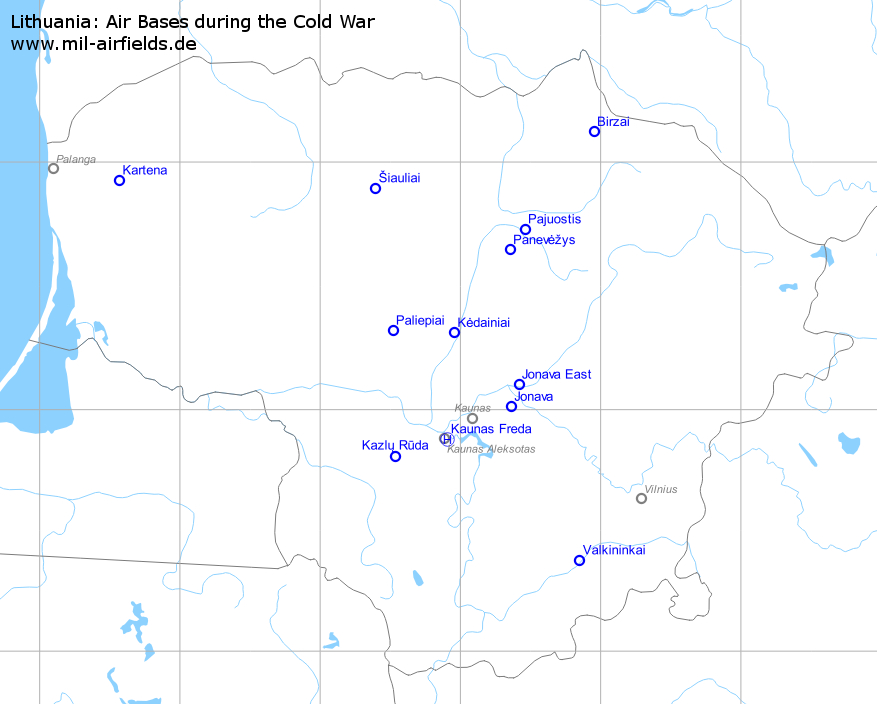
Military airfields in Lithuania (12)
Birzai: Highway Strip
For historical information only, do not use for navigation or aviation purposes!
| Coordinates | N560708 E0245708 (WGS84) Google Maps |
| Elevation | 250 ft |
Location of airfield
The highway strip is located ca. 15 km southeast of Biržai, on road 123.
Runways
- 10/28: 2500 m
Categories
Highway Strips WorldwideJonava: Airfield
Jonava Southeast, Gaižiūnai, Гайжюнай, Rukla, Аэродром Рукла
For historical information only, do not use for navigation or aviation purposes!
| Coordinates | N550039 E0242144 (WGS84) Google Maps |
| Elevation | 280 ft |
Location of airfield
The airfield is located ca. 8 km southeast of the city.
Usage during the Cold War
Soviet reserve air base and paratrooper base.
Use today
Closed.
Runways
- 12/30: 2400 m
Airfields in the vicinity
Jonava East: Airfield
Makštava, Аэродром Макштава
For historical information only, do not use for navigation or aviation purposes!
| Coordinates | N550605 E0242458 (WGS84) Google Maps |
| Elevation | 260 ft |
General
Reserve airfield.
Location of airfield
The airfield is located ca. 8 km east-northeast of Jonava.
Runways
- 09/27: 3000 m Grass
Airfields in the vicinity
Kartena: Highway Strip
For historical information only, do not use for navigation or aviation purposes!
| Coordinates | N555532 E0213405 (WGS84) Google Maps |
| Elevation | 270 ft |
Location
Kartena is located ca. 30 km northeast of Klaipėda.
Location of airfield
The highway strip beginns 5 km east of Kartena, on the A11.
Runways
- 08/26: 2500 m
Categories
Highway Strips WorldwideKaunas: Heliport
Freda, Каунас
For historical information only, do not use for navigation or aviation purposes!
| Coordinates | N545241 E0235434 (WGS84) Google Maps |
Usage during the Cold War
Soviet helicopter base.
Use today
Closed.
Airfields in the vicinity
Kazlų Rūda: Airfield
Kazlu Ruda, Kazlų Rūdos aerodromas
For historical information only, do not use for navigation or aviation purposes!
| Coordinates | N544823 E0233156 (WGS84) Google Maps |
| Elevation | 235 ft |
Location of airfield
The airfield is located ca. 6 km north-northeast of Kazlų Rūda.
Usage during the Cold War
Soviet reserve air base.
Use today
Closed, used for car races.
Runways
- 12/30: 2200 m
Airfields in the vicinity
- 072°/25km Kaunas: Heliport (Freda, Каунас)
Kėdainiai: Air Base
Kedainia, Аэродром Кедайняй
For historical information only, do not use for navigation or aviation purposes!
| Coordinates | N551842 E0235723 (WGS84) Google Maps |
| Elevation | 165 ft |
Location of airfield
The airfield is located at the nordern edge of Kėdainiai.
Usage during the Cold War
Soviet transport aircraft base.
Use today
Closed.
Runways
- 16/34: 2000 m
Airfields in the vicinity
Pajuostis: Air Base
Tulpe, Panevezys, Аэродром Паневежис
For historical information only, do not use for navigation or aviation purposes!
| Coordinates | N554347 E0242734 (WGS84) Google Maps |
| Elevation | 197 ft |
| Location indicator | EYPP |
Location of airfield
The airfield is located ca. 5 km east-southeast of Panevėžys.
Usage during the Cold War
Soviet air base until 199x (128 VTAP/128 втап: Il-76)
Use today
Military airfield.
Runways
- 13/31: 2000 m x 41 m Concrete
Installations
Railway siding from the north-west.
Airfields in the vicinity
- 216°/11km Panevėžys: Highway Strip (Panevezys)
Paliepiai: Airfield
For historical information only, do not use for navigation or aviation purposes!
| Coordinates | N551915 E0233103 (WGS84) Google Maps |
| Elevation | 315 ft |
General
Reserve airfield.
Runways
- 04/22: 3000 m
Links
- http://www.flickr.com/photos/martintrolle/sets/721... - Soviet Air Force Base, Paliepiai Pictures
Airfields in the vicinity
Panevėžys: Highway Strip
Panevezys
For historical information only, do not use for navigation or aviation purposes!
| Coordinates | N553847 E0242112 (WGS84) Google Maps |
| Elevation | 215 ft |
General
This highway strip is mentioned at TPC maps, but it cannot be fully confirmed by satellite images and Google Street View.
Runways
- 02/20
Airfields in the vicinity
Categories
Highway Strips WorldwideŠiauliai: Air Base
Siauliai, Zoknių aerodromas, Аэродром Шяуляй, Зокняй, Zokniai
For historical information only, do not use for navigation or aviation purposes!
| Coordinates | N555340 E0232342 (WGS84) Google Maps |
| Elevation | 443 ft |
| Location indicator | EYSA |
Location of airfield
The airfield is located ca. 5 km southeast of the town center.
Usage during the Cold War
Soviet air base (Early warning aircraft).
Use today
Military air base with civilian use.
Runways
- 14L/32R: 3500 m
- 14R/32L: 3280 m
Links
- http://community.livejournal.com/ru_aviation/12468... - Pictures of Tu-126 and A-50 at Šiauliai
Valkininkai: Airfield
Dargužiai, Darguziai
For historical information only, do not use for navigation or aviation purposes!
| Coordinates | N542241 E0245103 (WGS84) Google Maps |
| Elevation | 410 ft |
Location
Dargužiai is located ca. 40 km southwest of Vilnius.
Location of airfield
The airfield is located ca. 2 km west-southwest of Dargužiai.
Usage during the Cold War
Reserve airfield.
Runways
- 05/23: 2000 m Grass
Other Airfields
The purpose of the following airfields remained unclear to me:- Kaunas: For the place of today's Kaunas airport, old TPC maps show an airfield with an unpaved runway of 8200 feet (=2500 m). This could have been a soviet reserve airfield.
- Valkininkai / Darguziai: This airfield is located 45 km southwest of Vilnius and is still active. This could have been a soviet reserve airfield as well.
Glossary
The following terms might help you for your own research on search engines. I'm not an expert for Lithuanian, so it is without warranty. Corrections and additions are welcome!| English | Lithuanian | Russian |
|---|---|---|
| Airfield | aerodromas | аэродром |
| Airport | oro uostas | аэропорт |
| Call Sign | позывной | |
| Lithuania | Lietuva | Литва |