Funkfeuer in Frankreich in den 1950er Jahren
Navaids: NDB, Range, ILS
Nur zur geschichtlichen Information, nicht zur Navigation oder zum Fliegen verwenden!
Die folgende Liste enthält die Luftfahrt-Funkfeuer, die in Frankreich Mitte der 1950er Jahre aktiv waren. Alle Informationen sind veraltet und dürfen nicht für navigatorische Zwecke verwendet werden.
Zu dieser Zeit wurden überwiegend ungerichtete Funkfeuer (NDB) genutzt. Zusätzlich gab es noch einzelne Ranges, aber der Bestand ging zurück. Dafür waren erste UKW-Drehfunkfeuer (VOR) im Einsatz. Die großen Flughäfen des Landes waren mit einem Instrumentenlandesystem (ILS) ausgestattet.
Bemerkenswert ist, dass es in Istres noch immer ein Eureka-Funkfeuer gab. Das scheint das letzte der ohnehin wenigen Eurekas in Frankreich gewesen zu sein.
Funkfeuer und Luftstraßen 1955
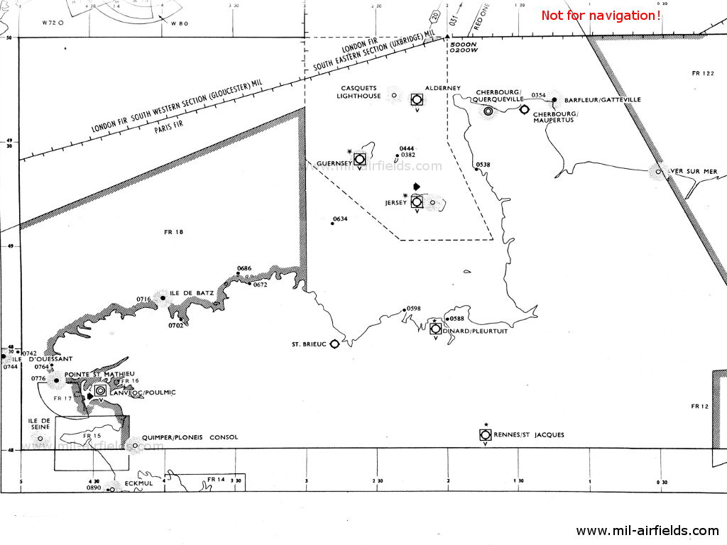
Normandie, Bretagne (Quelle: DoD)
Île-de-France (Quelle: DoD)
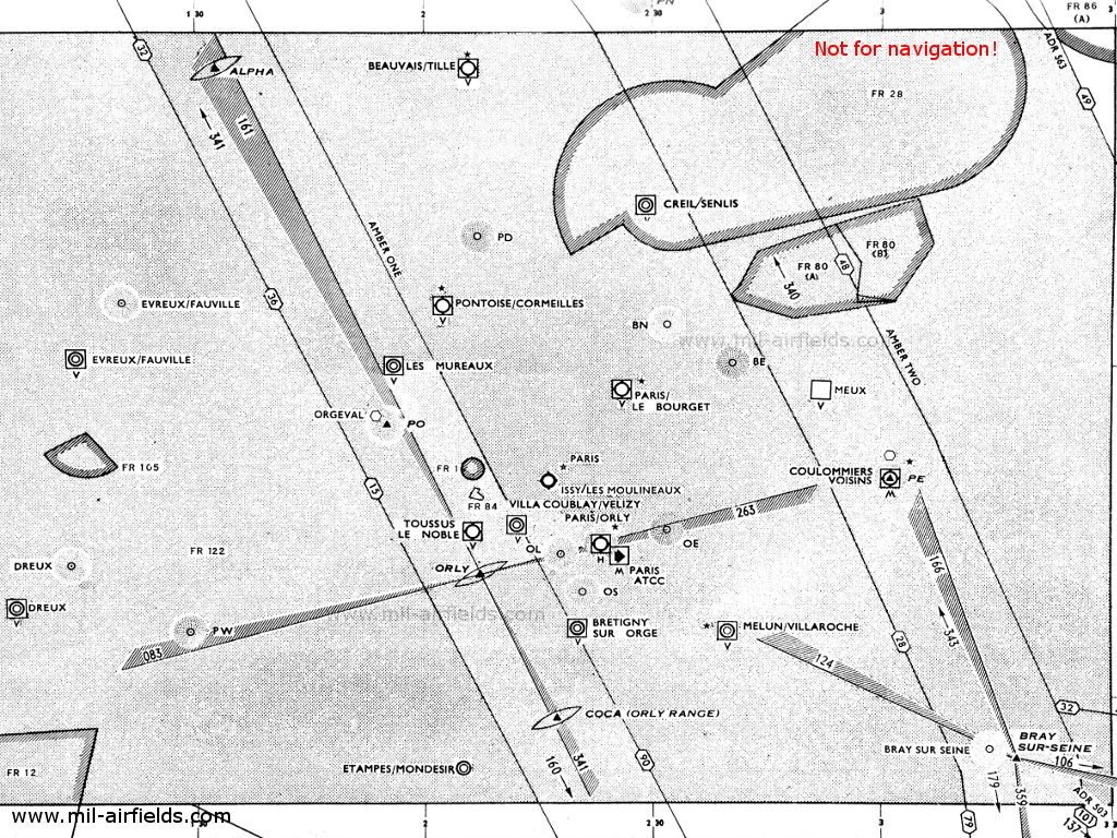
Vergrößerung Paris (Quelle: DoD)
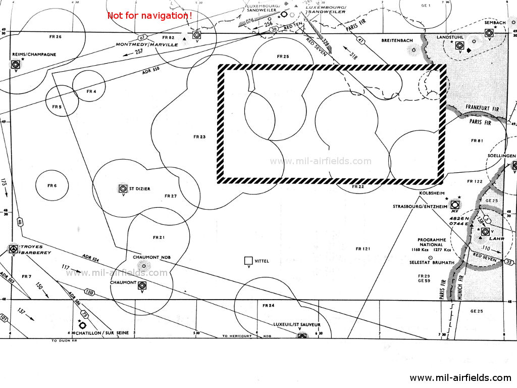
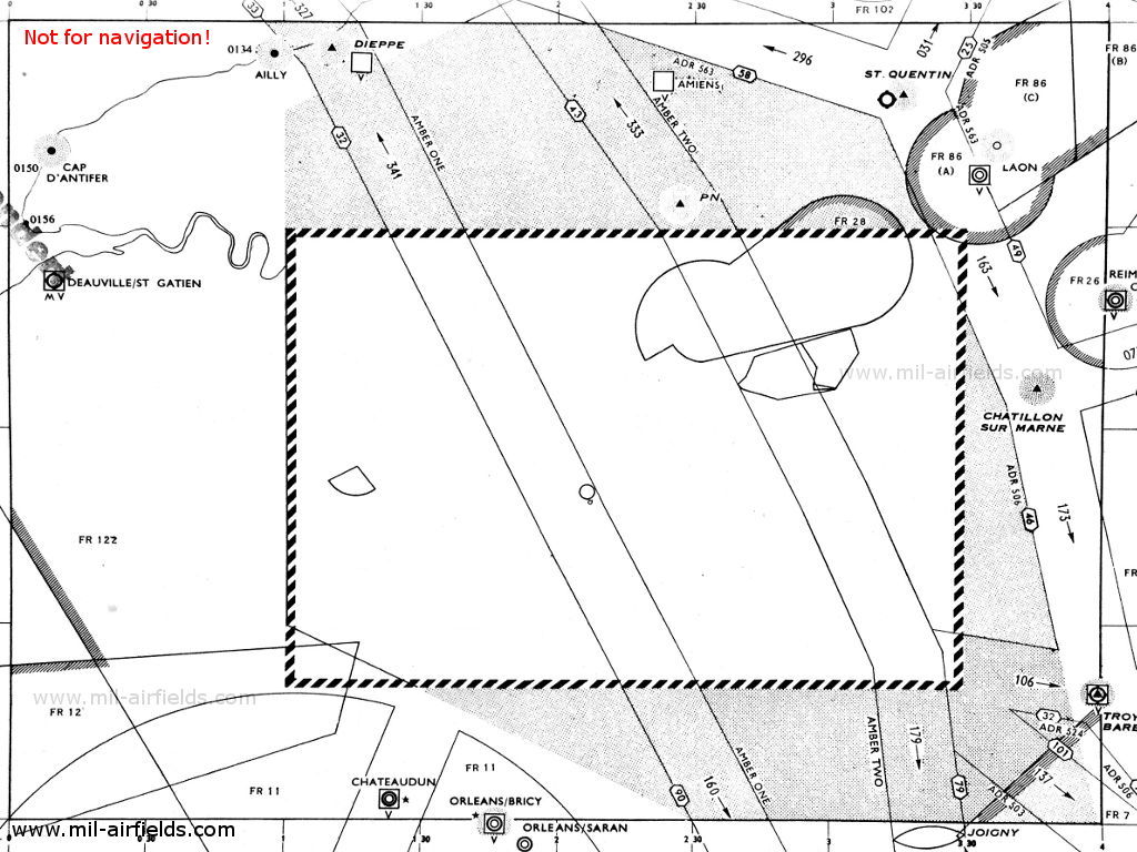
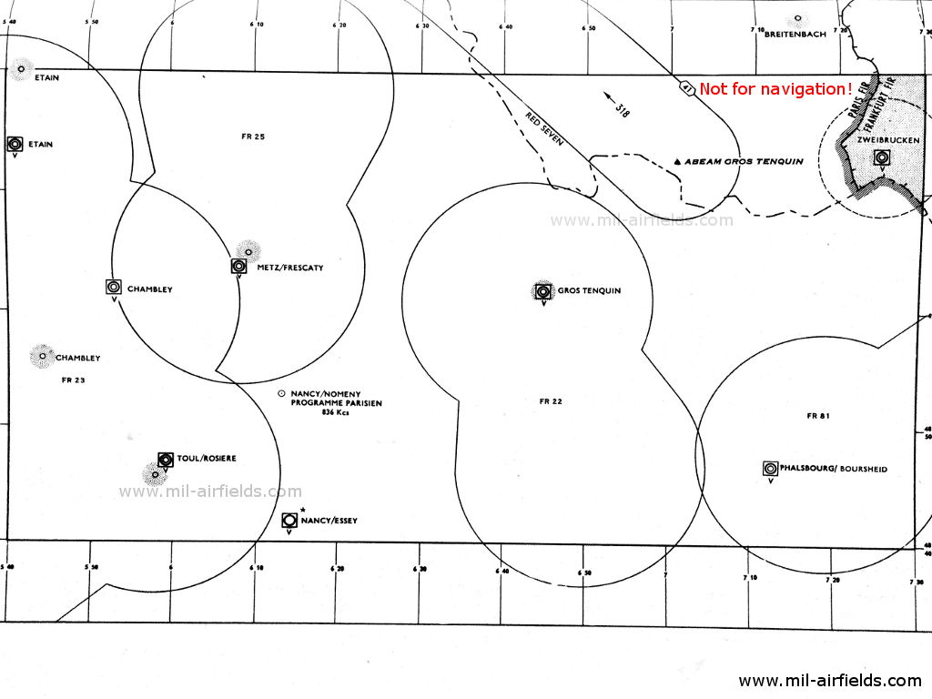
Alsace, Ardenne, Champagne, Lorraine (Quelle: DoD)
Vergrößerung (Quelle: DoD)
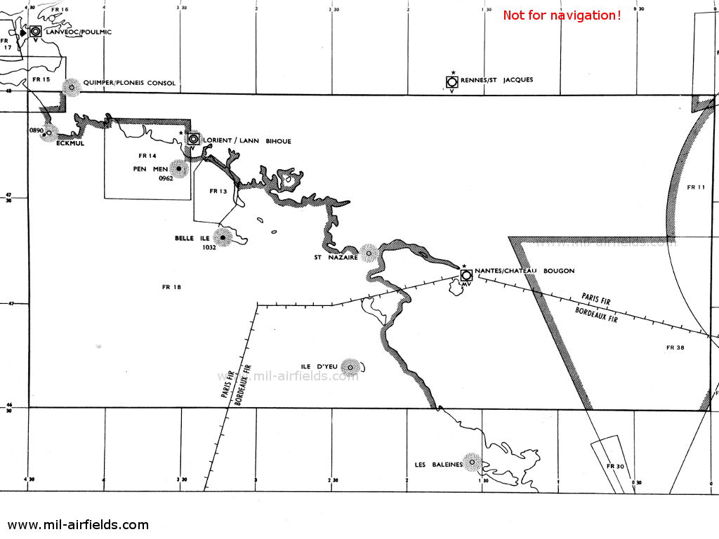
Bretagne, Loire, Aquitaine (Quelle: DoD)
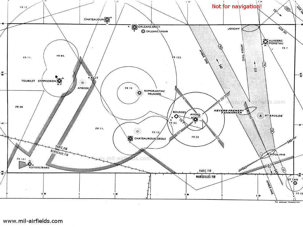
Val de Loire (Quelle: DoD)
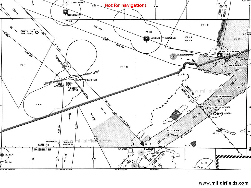
Bourgogne (Quelle: DoD)
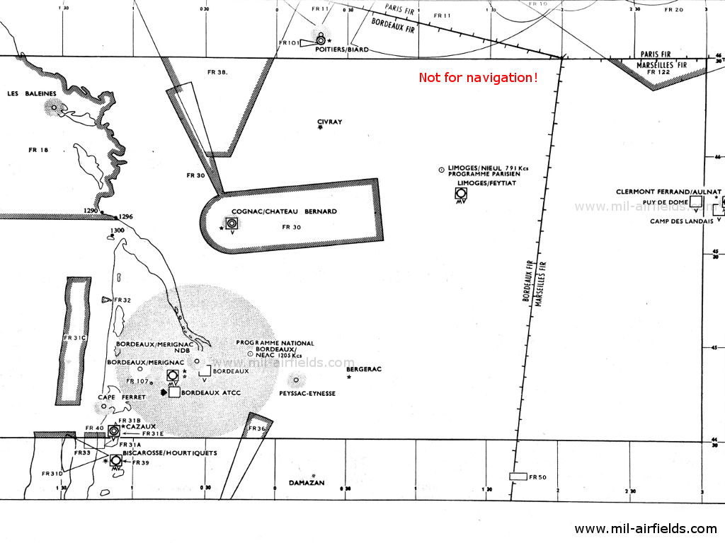
Aquitaine / Bordeaux (Quelle: DoD)
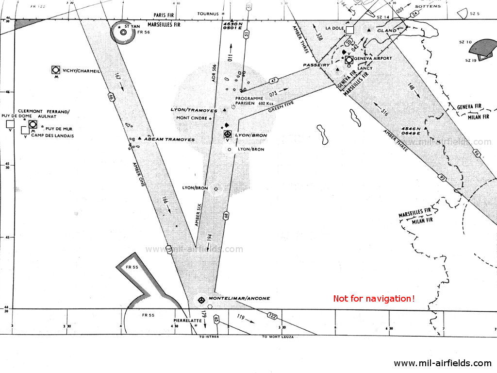
Rhône-Alpes (Quelle: DoD)
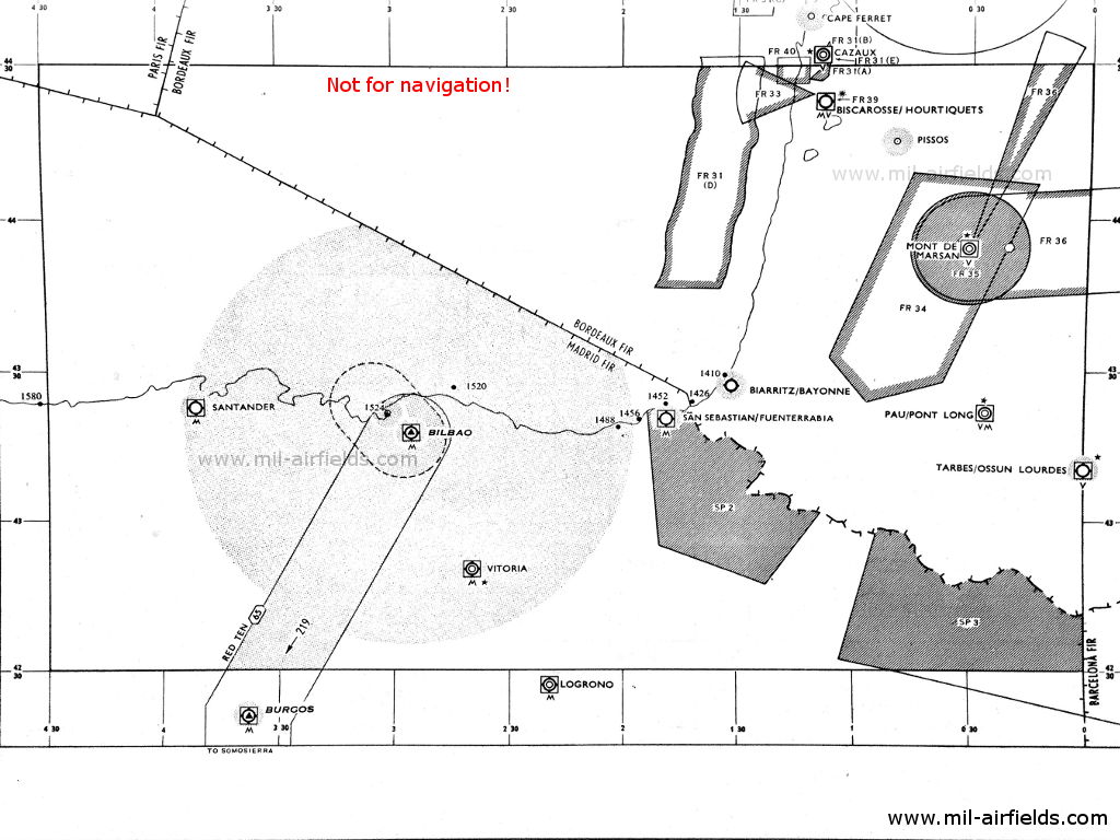
Pyrénées-Atlantiques (Quelle: DoD)
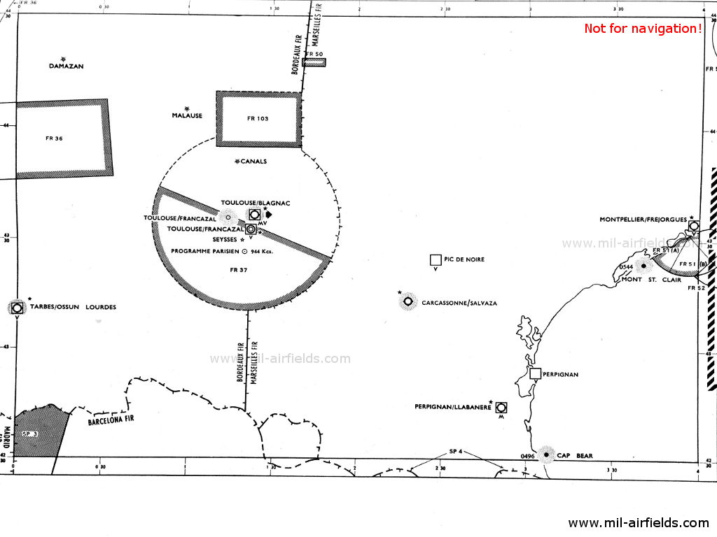
Midi-Pyrénées, Languedoc-Roussillon (Quelle: DoD)
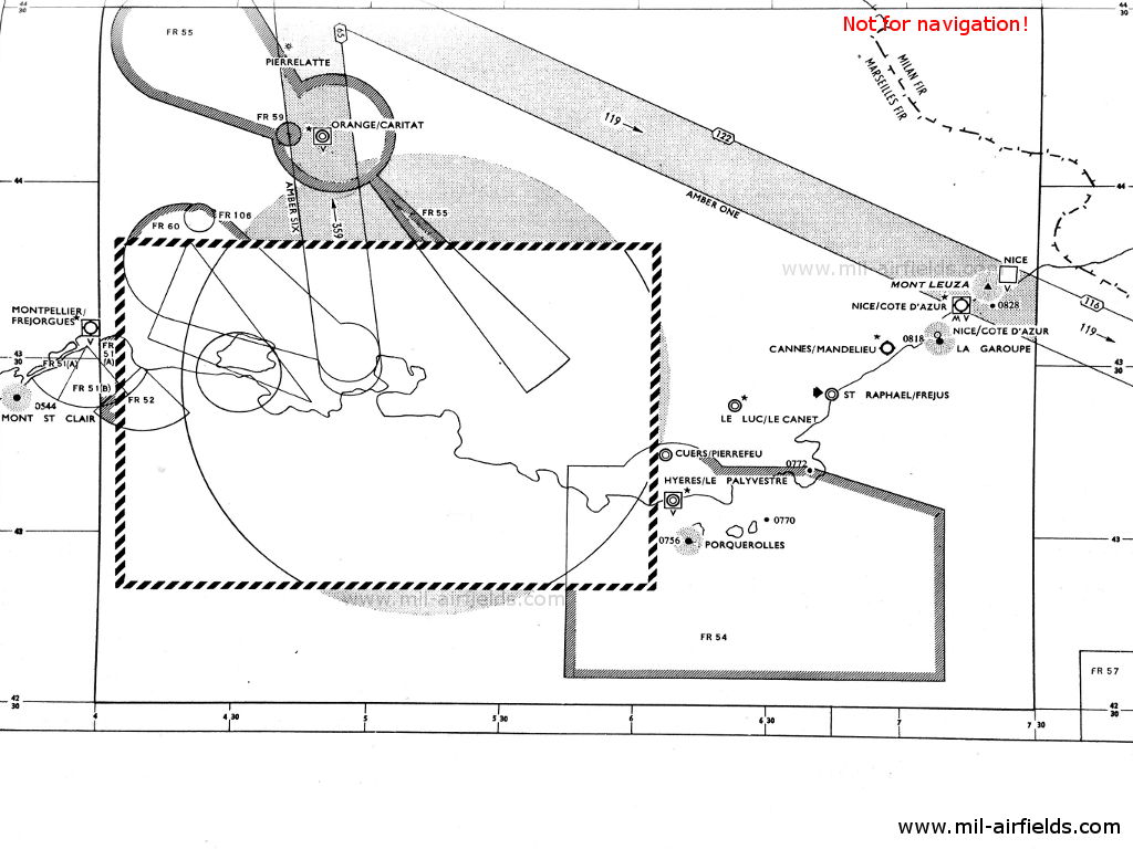
Côte d’Azur (Quelle: DoD)
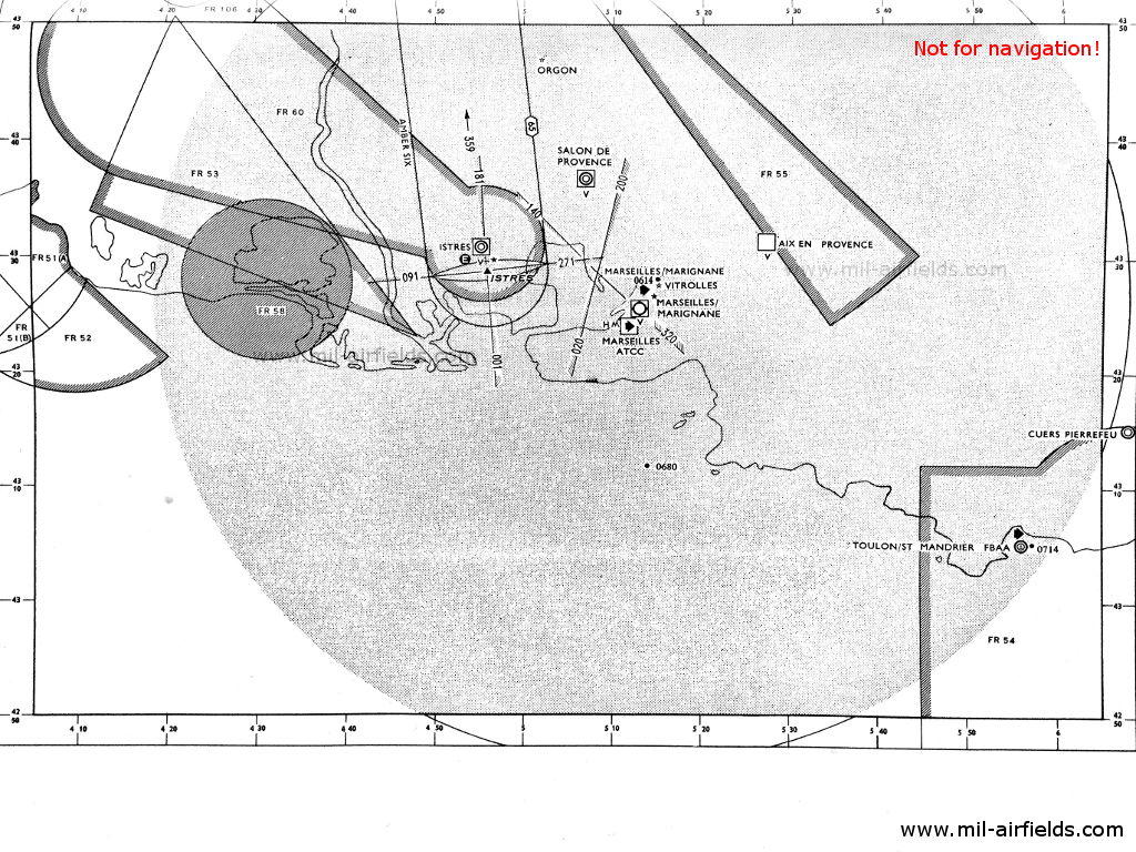
Vergrößerung Istres, Marseilles (Quelle: DoD)
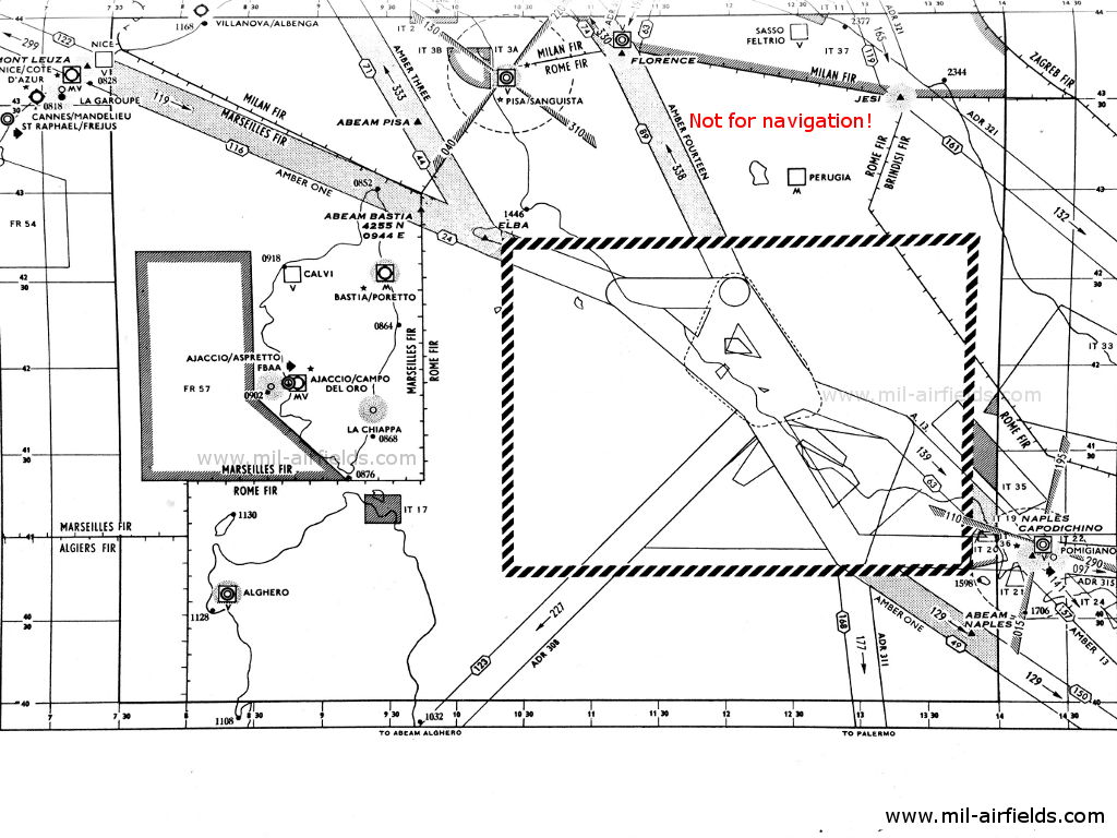
Korsika (Corse) (Quelle: DoD)
Erläuterungen
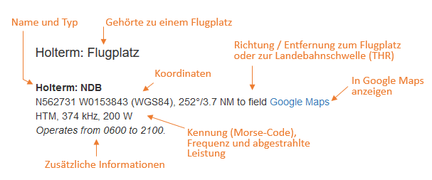
Abkürzungen
| approx. | approximately | ungefähr |
| civ | civil | ziviler Betreiber |
| GP | Glide path | Gleitwegsender |
| ILS | Instrument Landing System | Instrumentenlandesystem |
| IM | Inner Marker | Platzeinflugzeichen. (Markierungsfunkfeuer direkt vor der Landebahn) |
| kHz | Kilohertz | (Einheit für die Frequenz) |
| L | Locator | Ungerichtetes Funkfeuer für den Anflug |
| LLZ | Localizer | Landekurssender |
| LMM | Locator Middle Marker | Kombination aus Locator und Middle Marker |
| LOM | Locator Outer Marker | Kombination aus Locator und Outer Marker |
| m | Meter | (Einheit für die Länge) |
| MHz | Megahertz | (Einheit für die Frequenz) |
| mil | military | militärischer Betreiber |
| MM | Middle Marker | Haupteinflugzeichen (Markierungsfunkfeuer) |
| NDB | Non-directional beacon | Ungerichtetes Funkfeuer auf Lang- oder Mittelwelle |
| NM | Nautical Miles | Seemeilen |
| OM | Outer Marker | Voreinflugzeichen (Markierungsfunkfeuer) |
| PRMG | ПРМГ Посадочная радиомаячная группа | Sowjetisch / russisches militärisches Instrumentenlandesystem |
| RSBN | РСБН Rадиотехническая система ближней навигации | Sowjetisch / russisches militärisches Funknavigationssystem |
| SBA | Standard Beam Approach | Anflughilfe, Lorenz-System, Vorgänger des ILS |
| THR | Threshold | Landebahnschwelle (meist mit Nummer der Landebahn) |
| transf. | transformiert | Koordinaten wurden aus einem anderen Referenzsystem umgerechnet, daher sind Abweichungen möglich. |
| VAR | Visual-Aural Rnange | Range im UKW-Bereich mit optischen und akustischen Signalen |
| VOR | VHF Omnidirectional Radio Range | UKW-Drehfunkfeuer |
| W | Watt | (Einheit für die Leistung) |
| WGS84 | World Geodetic System 1984 | (Geodätisches Referenzsystem, GPS-Koordinaten) |
Verzeichnis
Nur zur geschichtlichen Information, nicht zur Navigation oder zum Fliegen verwenden!
Ailly: NDB (mil)
N4955 E00058 (approx.) Google Maps
AL, 310.3 kHz
N4955 E00058 (approx.) Google Maps
AL, 310.3 kHz
Military radio beacon. Operated H+00 and every 6 minutes.
Ajaccio: Flughafen Campo dell'Oro
Ajaccio/Campo dell'Oro: NDB
N4154 E00837 (approx.), 094°/7.0 NM to field Google Maps
AJ, 341 kHz, 40 W
N4154 E00837 (approx.), 094°/7.0 NM to field Google Maps
AJ, 341 kHz, 40 W
Avord: Flugplatz
Avord: NDB (FAF)
N4705 E00241 (approx.) Google Maps
AV, 289 kHz
N4705 E00241 (approx.) Google Maps
AV, 289 kHz
Operated on request for aircraft landing at Avord or Bourges.
Avord: Range (FAF)
N4705 E00241 (approx.) Google Maps
AV, 353 kHz
N4705 E00241 (approx.) Google Maps
AV, 353 kHz
The four predefined courses to the Range were 057°, 147°, 237° and 327°. Operated on request for aircraft landing at Avord or Bourges.
Barfleur/Gatteville: NDB
N4942 W00116 (approx.) Google Maps
FG, 291.9 kHz
N4942 W00116 (approx.) Google Maps
FG, 291.9 kHz
Operated H+04 and every 6 minutes.
Nur zur geschichtlichen Information, nicht zur Navigation oder zum Fliegen verwenden!
Basel-Mulhouse: Flughafen
Runway 16:
Basel/Mulhouse: ILS 16
FNH, 109.5 MHz
FNH, 109.5 MHz
Operated continuously in IFR. Other times on request to Tower with 10 minutes notice.
Basel/Mulhouse: MM 16
160°/0.55 to THR 16
Dots Dashes, 75 MHz
160°/0.55 to THR 16
Dots Dashes, 75 MHz
Basel/Mulhouse: LOM 16
N4740 E00729 (approx.), 160°/3.76 NM to THR 16 Google Maps
Locator: BN, 306.5 kHz, 40 W
Outer Marker: Dashes, 75 MHz
N4740 E00729 (approx.), 160°/3.76 NM to THR 16 Google Maps
Locator: BN, 306.5 kHz, 40 W
Outer Marker: Dashes, 75 MHz
Sierentz.
Bastia: Flughafen Poretta
Biarritz: Flughafen (Aéroport International de Biarritz Pays Basque)
Bordeaux: Flughafen Mérignac (Base aérienne 106 Bordeaux-Mérignac)
Runway 23:
Bray-sur-Seine: Range
N4824 E00318 (approx.) Google Maps
FNY, 277 kHz, 40 W
N4824 E00318 (approx.) Google Maps
FNY, 277 kHz, 40 W
The four predefined courses to the Range were 124°, 166°, 289° and 359°.
Nur zur geschichtlichen Information, nicht zur Navigation oder zum Fliegen verwenden!
Cap d'Antifer: NDB
N4941 E00010 (approx.) Google Maps
TI, 305.7 kHz
N4941 E00010 (approx.) Google Maps
TI, 305.7 kHz
Operated H+00 and every 2 minutes.
Carcassonne: Flughafen Salvaza
Chambley: Flugplatz Bussières
Châteauroux: Flugplatz Déols (Aéroport de Châteauroux-Centre)
Data for 1955:
Châteauroux: NDB (USAF)
N465149 E0014303 (WGS84, transf.) Google Maps
FDK, 466 kHz
Châteauroux: NDB (USAF)
N465149 E0014303 (WGS84, transf.) Google Maps
FDK, 466 kHz
At field.
Data for 1956:
Châteauroux: NDB (USAF)
N4656 E00148 (approx.), 220°/5.2 NM to field Google Maps
FDK, 466 kHz, 100 W
Châteauroux: NDB (USAF)
N4656 E00148 (approx.), 220°/5.2 NM to field Google Maps
FDK, 466 kHz, 100 W
In the approach sector for runway 22.
Chaumont: Flugplatz (Aérodrome de Chaumont-Semoutiers, Quartier General d’Aboville)
Runway 19:
Nur zur geschichtlichen Information, nicht zur Navigation oder zum Fliegen verwenden!
Cherbourg: Flugplatz Querqueville (Aérodrome de Querqueville)
Cherbourg/Querqueville: NDB (FNF)
N4940 W00139 (approx.) Google Maps
CHERBOURG, 298.8 kHz
N4940 W00139 (approx.) Google Maps
CHERBOURG, 298.8 kHz
Operated in fog H+01 and every 3 minutes.
Clermont Ferrand: Flughafen Aulnat
Clermont Ferrand/Aulnat: Locator
N4547 E00310 (approx.), 268°/3.2 NM to field Google Maps
CF, 261 kHz, 40 W
N4547 E00310 (approx.), 268°/3.2 NM to field Google Maps
CF, 261 kHz, 40 W
Cognac: Flugplatz Châteaubernard (Base aérienne 709, B.A. 709)
Coulommiers-Voisins: Flugplatz (Aérodrome de Coulommiers - Voisins)
Creil: Flugplatz (Base aérienne 110, BA 110)
Creil: NDB
N4915 E00231 (approx.) Google Maps
CL, 423 kHz
N4915 E00231 (approx.) Google Maps
CL, 423 kHz
Operated from 0730 to 1900 and on request 15 minutes before 1900.
Nur zur geschichtlichen Information, nicht zur Navigation oder zum Fliegen verwenden!
Dijon: Flugplatz Longvic (Base aérienne 102, B.A. 102, Aéroport de Dijon Bourgogne)
Dijon/Longvic: VOR (mil)
N4720 E00506 (approx.) Google Maps
FND, 113.5 MHz
N4720 E00506 (approx.) Google Maps
FND, 113.5 MHz
Operated during aerodrome times. On test.
Dreux: Flugplatz (Dreux/Louvillers)
Étain-Rouvres: Flugplatz
Évreux-Fauville: Flugplatz (Base aérienne 105, B.A. 105)
Évreux/Fauville: NDB (USAF)
N4906 E00120 (approx.), 266°/5.6 NM to field Google Maps
KC, 486 kHz, 100 W
N4906 E00120 (approx.), 266°/5.6 NM to field Google Maps
KC, 486 kHz, 100 W
Grostenquin: Flugplatz
Nur zur geschichtlichen Information, nicht zur Navigation oder zum Fliegen verwenden!
Île de Ouessant: NDB
N4828 W00508 (approx.) Google Maps
CA, 308 kHz
N4828 W00508 (approx.) Google Maps
CA, 308 kHz
Operated H+05 and every 6 minutes.
Istres: Flugplatz Le Tube (Base aérienne 125 Istres-Le Tubé (B.A. 125))
Istres: Range
N4329 E00456 (approx.), 001°/2.2 NM to field Google Maps
FNI, 278 kHz
N4329 E00456 (approx.), 001°/2.2 NM to field Google Maps
FNI, 278 kHz
The four courses to the Range were 001°, 091°, 181° and 271°.
Joigny: Marker
N4758 E00323 (approx.) Google Maps
F, 75 MHz, 100 W
N4758 E00323 (approx.) Google Maps
F, 75 MHz, 100 W
On south leg of Bray Range. Operated continously.
La Chiappa: NDB
N4136 E00922 (approx.) Google Maps
CP, 308 kHz
N4136 E00922 (approx.) Google Maps
CP, 308 kHz
Operated in clear weather H+14 and H+44; in fog H+02 and every 6 minutes.
Nur zur geschichtlichen Information, nicht zur Navigation oder zum Fliegen verwenden!
Lanvéoc-Poulmic: Flugplatz (Base aéronautique navale de Lanvéoc-Poulmic)
Lanvéoc/Poulmic: NDB (FNF)
N4817 W00427 (approx.) Google Maps
FUE, 222 kHz, 500 W
N4817 W00427 (approx.) Google Maps
FUE, 222 kHz, 500 W
Operated on 30 minutes request.
Laon: Flugplatz Couvron
Data for 1956:
Laon: NDB (USAF)
N4942 E00335 (approx.) Google Maps
CV, 344 kHz, 50 W
Laon: NDB (USAF)
N4942 E00335 (approx.) Google Maps
CV, 344 kHz, 50 W
In the approach sector for runway 21.
Lorient: Flugplatz Lann-Bihoué (Base aéronautique navale de Lann-Bihoué, Aéroport de Lorient-Bretagne-Sud)
Lorient: NDB (FNF)
N4747 W00327 (approx.) Google Maps
FUN, 387 kHz, 500 W
N4747 W00327 (approx.) Google Maps
FUN, 387 kHz, 500 W
Operated in IFR and on request.
Lyon: Flughafen Bron (Aéroport de Lyon-Bron)
Lyon/Bron: Range
N4541 E00457 (approx.) Google Maps
LY, 374 kHz
N4541 E00457 (approx.) Google Maps
LY, 374 kHz
Used until the early 1950s. The four predefined courses to the Range were 011°, 101°, 191° and 281°.
Runway 17:
Lyon/Bron: Locator
N4537 E00500 (approx.), 169°/5.67 NM to field Google Maps
BR, 388 kHz, 40 W
N4537 E00500 (approx.), 169°/5.67 NM to field Google Maps
BR, 388 kHz, 40 W
On test.
(The coordinates do not correspond to the direction & distance to the field.)
(The coordinates do not correspond to the direction & distance to the field.)
Runway 35:
Lyon/Bron: ILS 35
LY, 110.3 MHz
LY, 110.3 MHz
Operated continuously in IFR and on 20 minutes request.
Lyon/Bron: OM 35
349°/4.0 NM to THR 35
Dots Dashes, 75 MHz
349°/4.0 NM to THR 35
Dots Dashes, 75 MHz
Lyon/Bron: MM 35
349°/0.49 NM to THR 35
Dots Dashes, 75 MHz
349°/0.49 NM to THR 35
Dots Dashes, 75 MHz
Lyon/Bron: IM 35
349°/0.04 NM to THR 35
Dots, 75 MHz
349°/0.04 NM to THR 35
Dots, 75 MHz
Lyon/Tramoyes: NDB
N4553 E00457 (approx.) Google Maps
FOL, 602 kHz
N4553 E00457 (approx.) Google Maps
FOL, 602 kHz
Operates outside transmission hours of Lyon/Tramoyes Broadcast station, on test.
Nur zur geschichtlichen Information, nicht zur Navigation oder zum Fliegen verwenden!
Marseille: Flughafen Marignane (Aéroport Marseille Provence)
Marseille/Marignane: NDB
N4328 E00519 (approx.) Google Maps
FOM, 710 kHz, 650 W
N4328 E00519 (approx.) Google Maps
FOM, 710 kHz, 650 W
Operated weekdays from 0800 to 1100 and from 2300 to 0545, Sundays from 2300 to 0630. Marseille/Realtor broadcast station operates outside these times.
Runway 14:
Marseille/Marignane: Range
N4329 E00508 (approx.), 140°/4.2 NM to THR 14 Google Maps
FNM, 383 kHz, 100 W
N4329 E00508 (approx.), 140°/4.2 NM to THR 14 Google Maps
FNM, 383 kHz, 100 W
Runway 32:
Marseille/Marignane: ILS 32
ML, 110.3 MHz
ML, 110.3 MHz
Operated continuously in IFR and on 15 minutes request to ATC.
Marseille/Marignane: OM 32
320°/4.2 NM to THR 32
Dashes, 75 MHz
320°/4.2 NM to THR 32
Dashes, 75 MHz
Operated continuously. Also used as Z Marker for the Marseille Range.
Marseille/Marignane: IM 32
320°/0.05 NM to THR 32
Dots, 75 MHz
320°/0.05 NM to THR 32
Dots, 75 MHz
Metz-Frescaty: Flugplatz
Metz/Frescaty: NDB
N4905 E00609 (approx.) Google Maps
MZ, 521 kHz, 40 W
N4905 E00609 (approx.) Google Maps
MZ, 521 kHz, 40 W
Operated during aerodrome times.
Mont Saint-Clair: NDB
N4323 E00341 (approx.) Google Maps
SE, 305.7 kHz
N4323 E00341 (approx.) Google Maps
SE, 305.7 kHz
Operated in fog H+00 and every 4 minutes.
Mont-de-Marsan: Flugplatz
Mont-de-Marsan: VOR
N4355 W00018 (approx.) Google Maps
MR, 108.6 MHz, 50 W
N4355 W00018 (approx.) Google Maps
MR, 108.6 MHz, 50 W
Operated from 0800 to sunset plus 45 minutes.
Montélimar: Flughafen Ancône (Aérodrome de Montélimar-Ancône)
Marville: RCAF Station (RCAF Station Marville, Aérodrome de Montmédy-Marville)
Nur zur geschichtlichen Information, nicht zur Navigation oder zum Fliegen verwenden!
Moulins: Marker
N4642 E00338 (approx.) Google Maps
75 MHz
N4642 E00338 (approx.) Google Maps
75 MHz
Der Marker befand sich wahrscheinlich an der Position des Ranges, siehe nachfolgender Eintrag.
Moulins: Range
N464224 E0033754 (WGS84, approx.) Google Maps
FNC, 324 kHz
N464224 E0033754 (WGS84, approx.) Google Maps
FNC, 324 kHz
Die vier vordefinierten Leitstrahlen der Range sind 065°, 163°, 245° and 343°.
Das Range-Funkfeuer befand sich vermutlich 3 km südöstlich von Gannay-sur-Loire, westlich der Straße D15. Bei den angegebenen Koordinaten ist auf Satellitenbildern noch vier runde Fundamente der Range-Masten erkennbar.
Nice: Flughafen (Aéroport Nice Côte d’Azur, Aérodrome de Nice - Californie, Le Var)
Orléans: Flugplatz Bricy (Base aérienne 123, B.A. 123)
Nur zur geschichtlichen Information, nicht zur Navigation oder zum Fliegen verwenden!
Paris: Flughafen Le Bourget (Aéroport de Paris-Le Bourget)
Runway 21:
Paris/Le Bourget: ILS 21
LBS, 109.1 MHz
LBS, 109.1 MHz
Operated continuously in IFR.
Paris/Le Bourget: OM 21
210°/3.86 NM to THR 21
Dashes, 75 MHz
210°/3.86 NM to THR 21
Dashes, 75 MHz
Paris/Le Bourget: MM 21
210°/0.57 NM to THR 21
Dots Dashes, 75 MHz
210°/0.57 NM to THR 21
Dots Dashes, 75 MHz
Paris/Le Bourget: IM 21
210°/0.05 NM to THR 21
Dots, 75 MHz
210°/0.05 NM to THR 21
Dots, 75 MHz
Runway 27:
Paris/Le Bourget: Mitry-Mory Locator
N4900 E00237 (approx.), 265°/6.4 NM to THR 27 Google Maps
BE, 356 kHz, 40 W
N4900 E00237 (approx.), 265°/6.4 NM to THR 27 Google Maps
BE, 356 kHz, 40 W
Paris/Le Bourget: ILS 27
LBW, 109.9 MHz
LBW, 109.9 MHz
Operated continuously in IFR.
Paris/Le Bourget: OM 27
265°/3.8 NM to THR 27
Dashes, 75 MHz
265°/3.8 NM to THR 27
Dashes, 75 MHz
Paris/Le Bourget: MM 27
265°/0.52 NM to THR 27
Dots Dashes, 75 MHz
265°/0.52 NM to THR 27
Dots Dashes, 75 MHz
Paris/Le Bourget: IM 27
265°/0.05 NM to THR 27
Dots, 75 MHz
265°/0.05 NM to THR 27
Dots, 75 MHz
Paris: Flughafen Orly
Paris/Orly: NDB
N4843 E00218 (approx.) Google Maps
OL, 277 kHz
N4843 E00218 (approx.) Google Maps
OL, 277 kHz
Operates when Orly Range is out of service.
Paris/Orly: Range
N4841 E00207 (approx.), 091°/3.3 NM to field Google Maps
FNO, 364.5 kHz, 100 W
N4841 E00207 (approx.), 091°/3.3 NM to field Google Maps
FNO, 364.5 kHz, 100 W
The four predefined courses to the Range were 083°, 161°, 263° and 341°.
Runway 03:
Paris/Orly: ILS 03
OLN, 110.3 MHz
OLN, 110.3 MHz
Paris/Orly: OM 03
026°/4.05 NM to THR 03
Dashes, 75 MHz
026°/4.05 NM to THR 03
Dashes, 75 MHz
Paris/Orly: MM 03
026°/0.55 NM to THR 03
Dots Dashes, 75 MHz
026°/0.55 NM to THR 03
Dots Dashes, 75 MHz
Runway 26L:
Paris/Orly: ILS 26
OLW, 109.5 MHz
OLW, 109.5 MHz
Paris/Orly: St. Leger LOM 26L
N4845 E00232 (approx.), 262°/4.0 NM to THR 26 Google Maps
Locator: OE, 348 kHz
Outer Marker: Dashes, 75 MHz
N4845 E00232 (approx.), 262°/4.0 NM to THR 26 Google Maps
Locator: OE, 348 kHz
Outer Marker: Dashes, 75 MHz
Previous frequency 328 kHz.
Paris/Orly: MM 26
262°/0.54 NM to THR 26
Dots Dashes, 75 MHz
262°/0.54 NM to THR 26
Dots Dashes, 75 MHz
Pen-Men: NDB
N4739 W00330 (approx.) Google Maps
GX, 303.4 kHz
N4739 W00330 (approx.) Google Maps
GX, 303.4 kHz
Île de Groix. Operated H+04 and every 6 minutes.
Pointe de Saint-Mathieu: NDB
N4820 W00446 (approx.) Google Maps
SM, 294.2 kHz
N4820 W00446 (approx.) Google Maps
SM, 294.2 kHz
Operated in fog H+01 and every 2 minutes.
Poitiers: Flughafen Biard
Nur zur geschichtlichen Information, nicht zur Navigation oder zum Fliegen verwenden!
Pontoise: Flugplatz Cormeilles
Runway 05:
Pontoise/Cormeilles: ILS
CVN, 110.1 MHz
CVN, 110.1 MHz
Operated on request.
Pontoise/Cormeilles: OM 05
052°/3.89 NM to THR 05
Dashes, 75 MHz
052°/3.89 NM to THR 05
Dashes, 75 MHz
Pontoise/Cormeilles: MM 05
052°/0.68 NM to THR 05
Dots Dashes, 75 MHz
052°/0.68 NM to THR 05
Dots Dashes, 75 MHz
Quimper/Plonéis: Consol
N4801 W00413 (approx.) Google Maps
TRQ, 257 kHz
N4801 W00413 (approx.) Google Maps
TRQ, 257 kHz
Operated continuously except from 0730 to 0745. 40 seconds keying cycle. Ignore count when test is being transmitted. Position lines obtained from this beacon within an arc from 245° (T) clockwise to 275° (T) will be up to 3° in error.
Reims: Flugplatz (Base aérienne 112 Reims-Champagne, B.A. 112)
Reims/Champagne: NDB
N4919 E00402 (approx.) Google Maps
RC, 310 kHz
N4919 E00402 (approx.) Google Maps
RC, 310 kHz
Operated during aerodrome times and on 30 minutes request for aircraft landing at Reims.
Romorantin: Flugplatz Pruniers
Romorantin: NDB (FAF)
N4719 E00141 (approx.) Google Maps
RT, 265 kHz, 60 W
N4719 E00141 (approx.) Google Maps
RT, 265 kHz, 60 W
Operated Monday to Friday from 0800 to 1645. As required by Avord.
Saint-Dizier: Flugplatz Robinson
Saint-Dizier: NDB (FAF)
N4838 E00455 (approx.) Google Maps
SD, 294 kHz, 500 W
N4838 E00455 (approx.) Google Maps
SD, 294 kHz, 500 W
For use of locally based aircraft.
Saint-Nazaire: NDB
N4715 W00215 (approx.) Google Maps
NZ, 289.6 kHz
N4715 W00215 (approx.) Google Maps
NZ, 289.6 kHz
Operated in fog H+00 and every 2 minutes.
Nur zur geschichtlichen Information, nicht zur Navigation oder zum Fliegen verwenden!
Saint-Quentin: Flugplatz
Salon-de-Provence: Flugplatz (Base aérienne 701, B.A. 701)
Salon-de-Provence: NDB
N4337 E00507 (approx.) Google Maps
SO, 267 kHz, 75 W
N4337 E00507 (approx.) Google Maps
SO, 267 kHz, 75 W
Operated during aerodrome times, may be interrupted without prior notice.
Strasbourg: Flughafen Entzheim
Tarbes: Flughafen (Aéroport International Tarbes-Lourdes-Pyrénées)
Tarbes/Ossun Lourdes: NDB
N4311 E00000 (approx.) Google Maps
TL, 321 kHz, 40 W
N4311 E00000 (approx.) Google Maps
TL, 321 kHz, 40 W
Operated from 0700 to 1800.
Toul-Rosières: Flugplatz (Base aérienne 136, B.A. 136)
Toulouse: Flughafen Blagnac
Runway 33:
Toulouse/Blagnac: ILS 33
TO, 109.9 MHz
TO, 109.9 MHz
Operated continuously in IFR, other times on 30 minutes request.
Toulouse/Blagnac: OM 33
331°/3.76 NM to THR 33
Dashes, 75 MHz
331°/3.76 NM to THR 33
Dashes, 75 MHz
Toulouse/Blagnac: MM 33
331°/0.66 NM to THR 33
Dots Dashes, 75 MHz
331°/0.66 NM to THR 33
Dots Dashes, 75 MHz
Toulouse/Blagnac: IM 33
331°/0.05 NM to THR 33
Dots, 75 MHz
331°/0.05 NM to THR 33
Dots, 75 MHz
Nur zur geschichtlichen Information, nicht zur Navigation oder zum Fliegen verwenden!
Toulouse: Flughafen Francazal
Toulouse/Francazal: NDB (mil)
N4336 E00114 (approx.) Google Maps
TF, 405 kHz
N4336 E00114 (approx.) Google Maps
TF, 405 kHz
Operated during aerodrome times.
Troyes: Flughafen Barberey
Ver-sur-Mer: NDB
N4920 W00031 (approx.) Google Maps
ER, 298.8 kHz
N4920 W00031 (approx.) Google Maps
ER, 298.8 kHz
Operated in fog H+00 and every 3 minutes.
Vichy: Flughafen Charmeil
Villacoublay: Flugplatz Vélizy
Villacoublay/Vélizy: NDB (FAF)
N4846 E00213 (approx.) Google Maps
VY, 315 kHz, 90 W
N4846 E00213 (approx.) Google Maps
VY, 315 kHz, 90 W
Operated from sunrise to sunset plus 45 minutes and on 15 minutes prior notice to ATC. On test.
Nur zur geschichtlichen Information, nicht zur Navigation oder zum Fliegen verwenden!
Empfohlen

Bildquellen sind auf der jeweiligen Zielseite angegeben, klicke auf die Vorschau um sie zu öffnen.