Luftfahrt-Funkfeuer in Portugal in den 1950er Jahren
Navaids: NDB, Range, ILS
Nur zur geschichtlichen Information, nicht zur Navigation oder zum Fliegen verwenden!
Die folgende Liste enthält die Luftfahrt-Funkfeuer, die in Portugal Mitte der 1950er Jahre aktiv waren. Alle Informationen sind veraltet und dürfen nicht für navigatorische Zwecke verwendet werden.
In dieser Zeit gab es nur ungerichtete Funkfeuer (NDB) und einige Ranges. Die Flughäfen von Lissabon, Porto und Santa Maria waren mit einem Instrumentenlandesystem ausgestattet. In den frühen 1950er Jahren gab es in Lissabon auch noch ein Eureka-Funkfeuer und ein Standard Beam Approach (SBA) (ehemals Lorenz-System).
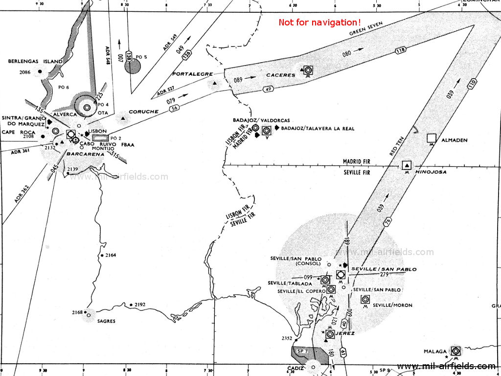
Funkfeuer und Luftstraßen 1955

Norden (Quelle: DoD)
Süden (Quelle: DoD)
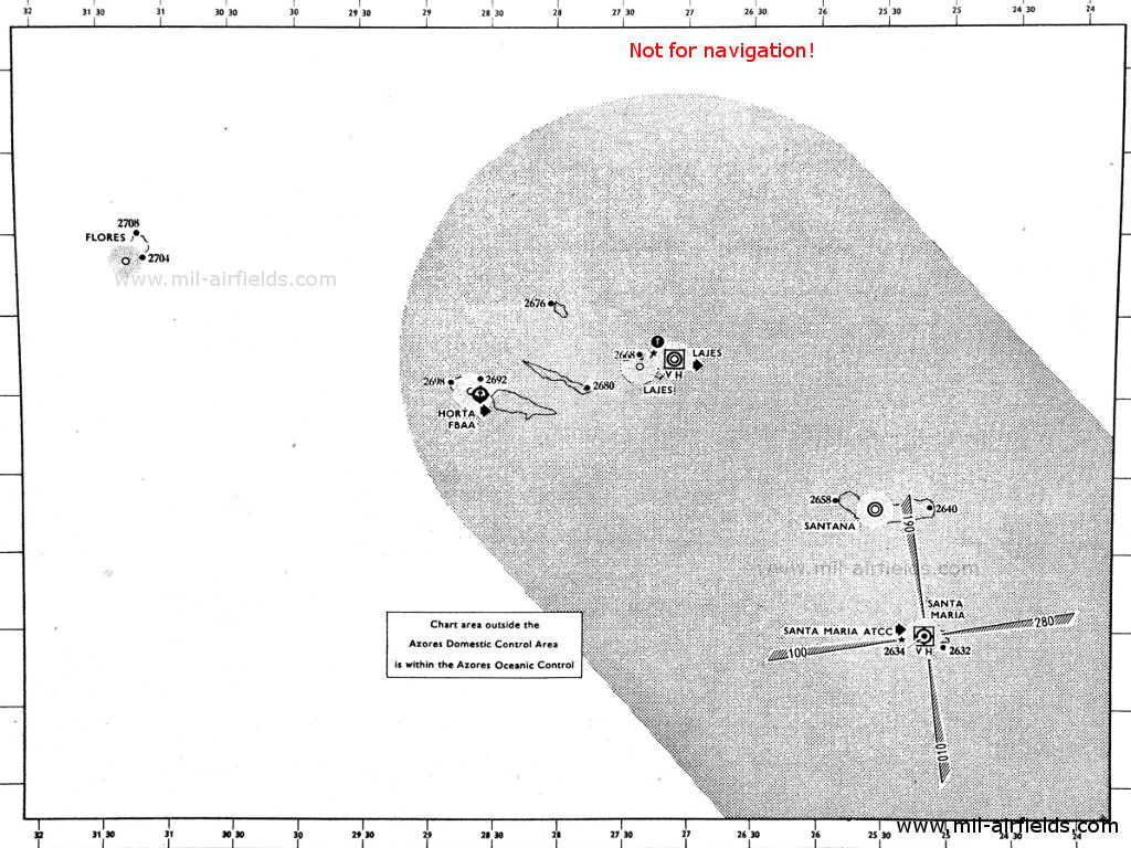
Azoren (Quelle: DoD)
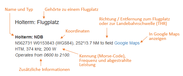
Erläuterungen
Abkürzungen
| approx. | approximately | ungefähr |
| civ | civil | ziviler Betreiber |
| GP | Glide path | Gleitwegsender |
| ILS | Instrument Landing System | Instrumentenlandesystem |
| IM | Inner Marker | Platzeinflugzeichen. (Markierungsfunkfeuer direkt vor der Landebahn) |
| kHz | Kilohertz | (Einheit für die Frequenz) |
| L | Locator | Ungerichtetes Funkfeuer für den Anflug |
| LLZ | Localizer | Landekurssender |
| LMM | Locator Middle Marker | Kombination aus Locator und Middle Marker |
| LOM | Locator Outer Marker | Kombination aus Locator und Outer Marker |
| m | Meter | (Einheit für die Länge) |
| MHz | Megahertz | (Einheit für die Frequenz) |
| mil | military | militärischer Betreiber |
| MM | Middle Marker | Haupteinflugzeichen (Markierungsfunkfeuer) |
| NDB | Non-directional beacon | Ungerichtetes Funkfeuer auf Lang- oder Mittelwelle |
| NM | Nautical Miles | Seemeilen |
| OM | Outer Marker | Voreinflugzeichen (Markierungsfunkfeuer) |
| PRMG | ПРМГ Посадочная радиомаячная группа | Sowjetisch / russisches militärisches Instrumentenlandesystem |
| RSBN | РСБН Rадиотехническая система ближней навигации | Sowjetisch / russisches militärisches Funknavigationssystem |
| SBA | Standard Beam Approach | Anflughilfe, Lorenz-System, Vorgänger des ILS |
| THR | Threshold | Landebahnschwelle (meist mit Nummer der Landebahn) |
| transf. | transformiert | Koordinaten wurden aus einem anderen Referenzsystem umgerechnet, daher sind Abweichungen möglich. |
| VAR | Visual-Aural Rnange | Range im UKW-Bereich mit optischen und akustischen Signalen |
| VOR | VHF Omnidirectional Radio Range | UKW-Drehfunkfeuer |
| W | Watt | (Einheit für die Leistung) |
| WGS84 | World Geodetic System 1984 | (Geodätisches Referenzsystem, GPS-Koordinaten) |
Verzeichnis
Nur zur geschichtlichen Information, nicht zur Navigation oder zum Fliegen verwenden!
Alverca: Flugplatz
Aveiro: Flugplatz (São Jacinto, Aeródromo Municipal de Aveiro)
Aveiro: NDB (PNAS)
N4039 W00845 (approx.) Google Maps
AV, 291.9 kHz
N4039 W00845 (approx.) Google Maps
AV, 291.9 kHz
Operated in clear weather H+14, 44; in fog: H+02 and every 6 minutes.
Berlengas: NDB
N3925 W00930 (approx.) Google Maps
IB, 287.3 kHz
N3925 W00930 (approx.) Google Maps
IB, 287.3 kHz
Berlenga Grande. Operated in clear weather H+04, 34; in fog H+04 and every 6 minutes.
Cape Roca: NDB
N3847 W00930 (approx.) Google Maps
RC, 308 kHz
N3847 W00930 (approx.) Google Maps
RC, 308 kHz
Cabo da Roca. Operated in clear weather H+06, 36; in fog H+00 and every 6 minutes.
Coruche: NDB
N3858 W00832 (approx.) Google Maps
CR, 389 kHz
N3858 W00832 (approx.) Google Maps
CR, 389 kHz
At the intersection of airways ADR (Advisory Route) 527, ADR 548 and ADR 549.
Nur zur geschichtlichen Information, nicht zur Navigation oder zum Fliegen verwenden!
Horta: Flugboot-Station
Horta: NDB (civ)
N3832 W02838 (approx.) Google Maps
FY, 294.5 kHz
N3832 W02838 (approx.) Google Maps
FY, 294.5 kHz
Azores (Açores). Operated on 30 minutes request to Santa Maria.
Lajes (Base Aérea das Lajes, Base Aérea Nº 4, BA4)
Lajes: Racon (USAF)
N384456 W0270424 (approx.), 247°/0.42 NM to field Google Maps
2, 9310 MHz
N384456 W0270424 (approx.), 247°/0.42 NM to field Google Maps
2, 9310 MHz
Operated continuously.
Runway 16:
Lajes: NDB
N3846 W02707 (approx.) Google Maps
GP, 341 kHz, 400 W
N3846 W02707 (approx.) Google Maps
GP, 341 kHz, 400 W
In the early 1950s, this beacon was a Range (courses: 073°, 163°, 253° and 343°)
Runway 34:
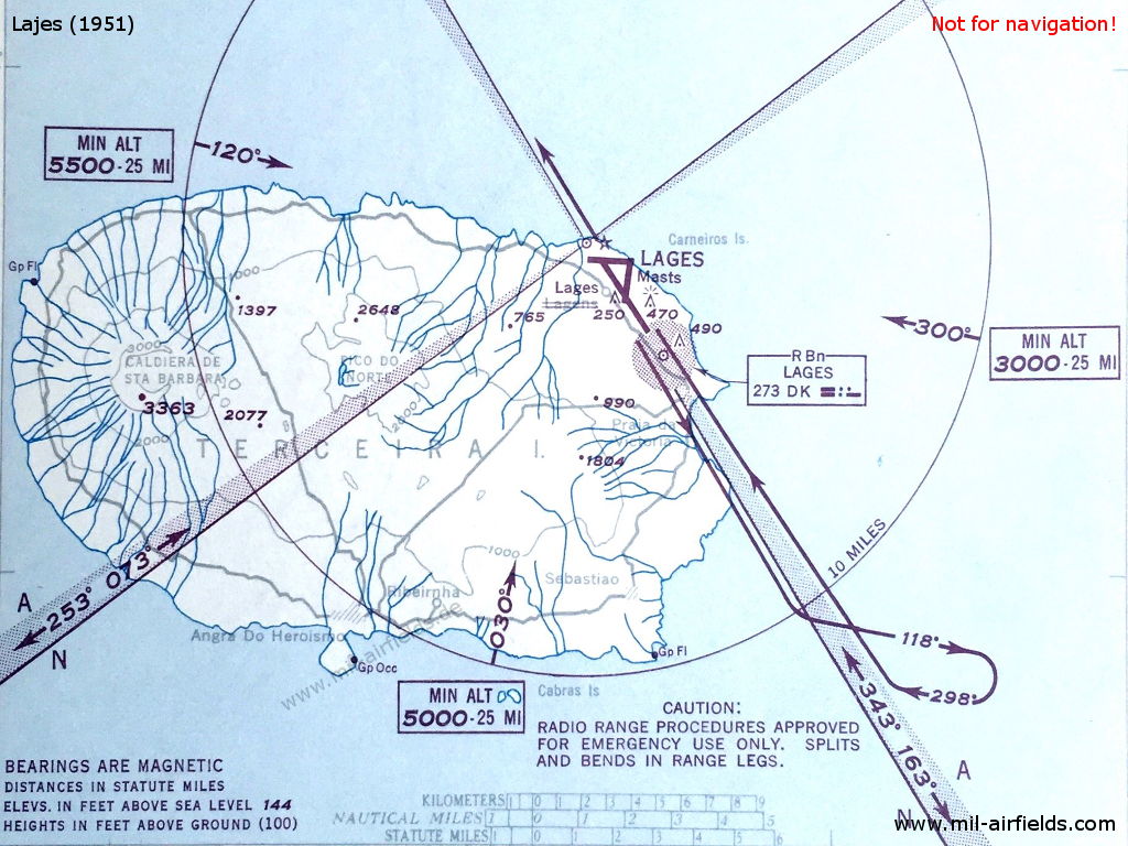
Range-Anflug auf den Flugplatz Lajes (Azoren) im Jahr 1951 - Die Range befindet sich unmittelbar nordöstlich vom Flugplatz. Die vier Kurse der Range und die A/N-Sektoren sind auf der Karte verzeichnet. (Quelle: DoD)
Leça: NDB
N4112 W00843 (approx.) Google Maps
LC, 291.9 kHz
N4112 W00843 (approx.) Google Maps
LC, 291.9 kHz
Leça da Palmeira. Operated in clear weather H+16, 46; in fog: H+04 and every 6 minutes.
Lissabon: Flughafen (Aeroporto de Lisboa, Aeroporto da Portela, Aeroporto Humberto Delgado)
Lisbon: Eureka
Lisbon: SBA
Runway 23:
Lisbon: Range
N3849 W00906 (approx.), 225°/3.0 NM to field Google Maps
PL, 382 kHz
N3849 W00906 (approx.), 225°/3.0 NM to field Google Maps
PL, 382 kHz
The four predefined courses to the range were 045°, 135°, 225° and 315°.
Lisbon: ILS 23
PA, 109.5 MHz
PA, 109.5 MHz
Operated on request.
Lisbon: LOM 23
225°/4.0 NM to THR 23
Locator: OL, 224 kHz
225°/4.0 NM to THR 23
Locator: OL, 224 kHz
Operated on request.
Lisbon: LMM 23
223°/0.57 NM to THR 23
Locator: L, 207 kHz
223°/0.57 NM to THR 23
Locator: L, 207 kHz
Operated on request.
Lisbon: IM 23
225°/0.03 NM to THR 23
Dots, 75 MHz
225°/0.03 NM to THR 23
Dots, 75 MHz
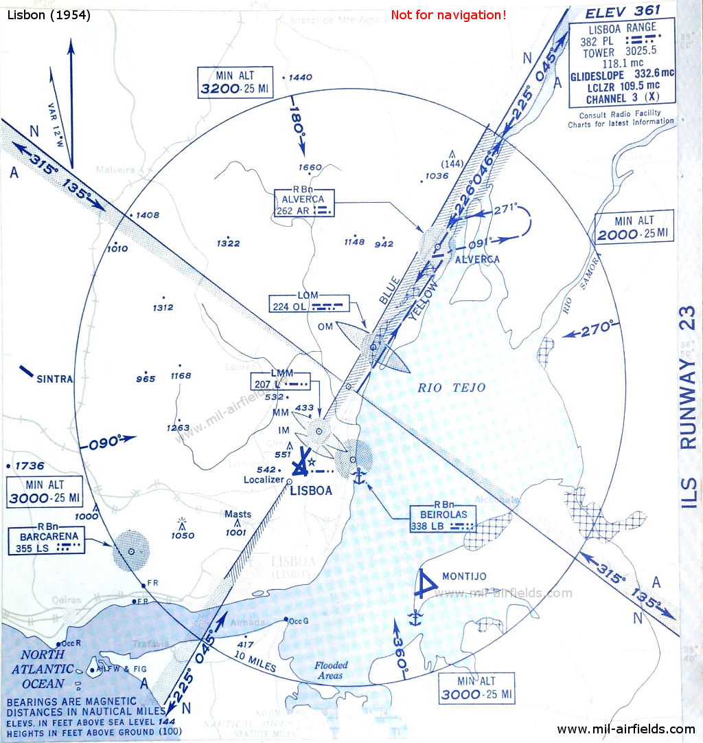
ILS-Anflug auf die Landebahn 23 in Lissabon im Jahr 1954 - In der Mitte des Kreises befindet sich die Lissabon Range. (Quelle: DoD)
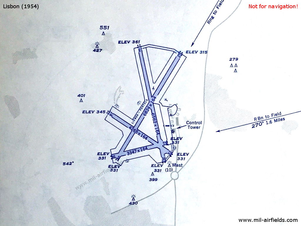
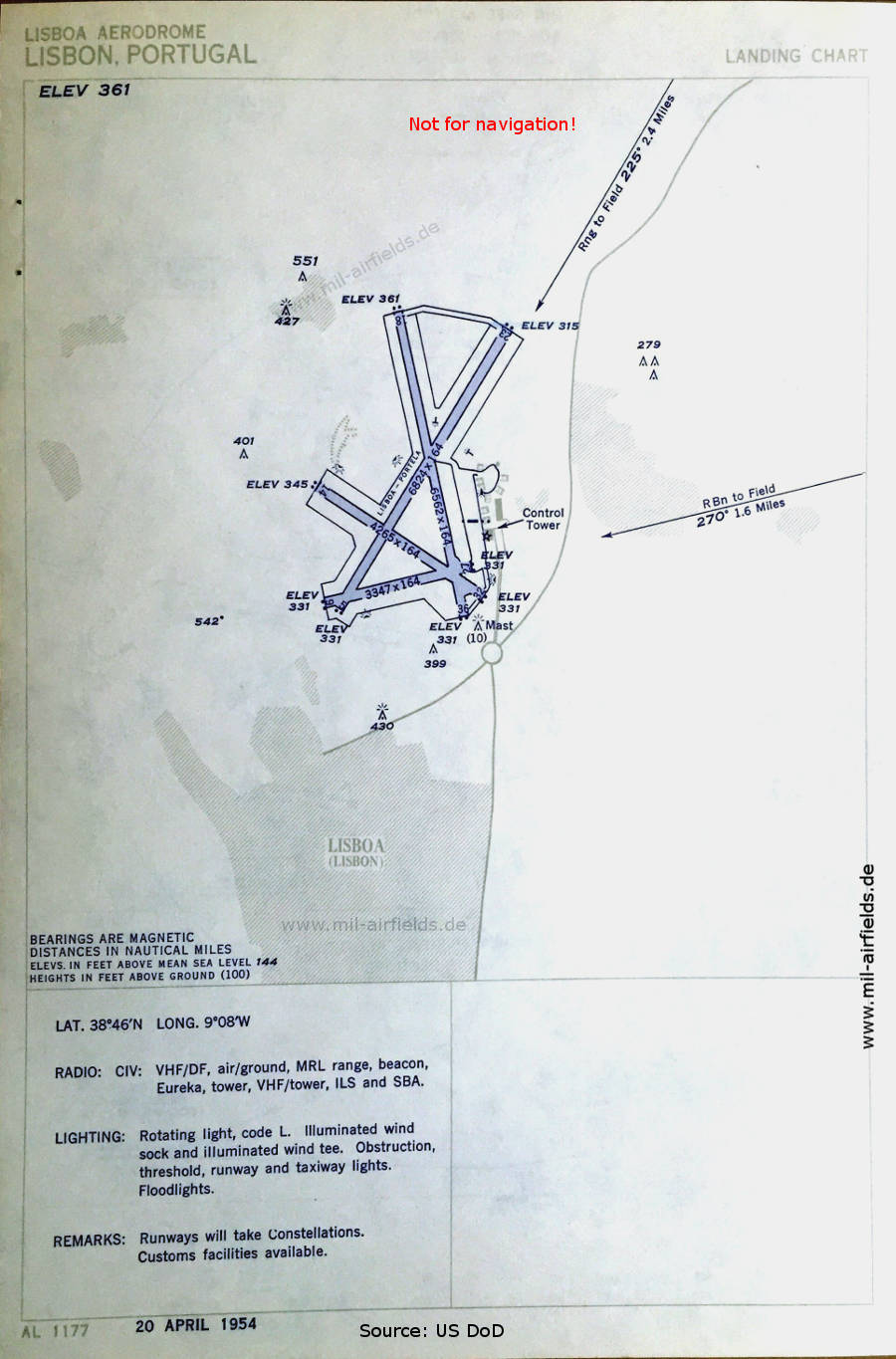
Flughafen Lissabon 1954 (Quelle: DoD)
Mont D'Or: NDB
N4145 W00852 (approx.) Google Maps
MR, 291.9 kHz
N4145 W00852 (approx.) Google Maps
MR, 291.9 kHz
Montedor. Operated in clear weather H+12, 42; in fog: continuous.
Montijo: Flugplatz
Nur zur geschichtlichen Information, nicht zur Navigation oder zum Fliegen verwenden!
Ota: Flugplatz
Porto: Flughafen (Aeroporto Francisco Sá Carneiro)
Runway 18:
Porto: NDB
181°/2.2 NM to field
PO, 327 kHz, 350 W
181°/2.2 NM to field
PO, 327 kHz, 350 W
Porto: ILS 18
PR, 109.5 MHz
PR, 109.5 MHz
Operated on request. On test.
Porto: MM 18
181°/0.6 NM to THR 18
Dots Dashes, 75 MHz
181°/0.6 NM to THR 18
Dots Dashes, 75 MHz
Porto: IM 18
181°/0.43 NM to THR 18
Dots, 75 MHz
181°/0.43 NM to THR 18
Dots, 75 MHz
Santa Maria: Flughafen
Runway 01:
Santa Maria: Range/Z Marker
N3657 W02510 (approx.) Google Maps
Range: STA, 240 kHz
Z Marker: 75 MHz
N3657 W02510 (approx.) Google Maps
Range: STA, 240 kHz
Z Marker: 75 MHz
The four predefined courses to the Range were 010°, 100°, 190° and 280°.
Runway 19:
Santa Maria: ILS 19
SM, 110.3 MHz
SM, 110.3 MHz
Santa Maria: MM 19
190°/0.61 NM to THR 19
Dots Dashes, 75 MHz
190°/0.61 NM to THR 19
Dots Dashes, 75 MHz
Santa Maria: IM 19
190°/0.04 NM to THR 19
Dots, 75 MHz
190°/0.04 NM to THR 19
Dots, 75 MHz
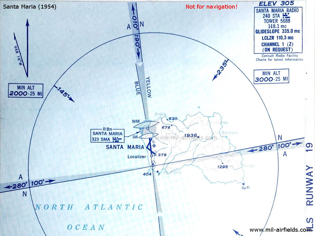
Santa Maria, Azoren, 1954: ILS-Anflug Landebahn 19. - Südlich des Platzes befindet sich die Range mit ihren vier Kursen und den A/N-Sektoren. (Quelle: DoD)
Santana: Flughafen (Aeródromo de Santana)
Santana: NDB (PAF)
N3749 W02534 (approx.) Google Maps
SML, 371 kHz, 1200 W
N3749 W02534 (approx.) Google Maps
SML, 371 kHz, 1200 W
Rabo de Peixe, Ribeira Grande, Azores (Açores).
Sintra: Flugplatz (Base Aérea de Sintra, Base Aérea Nº1, BA1)
Nur zur geschichtlichen Information, nicht zur Navigation oder zum Fliegen verwenden!
Vilar Formoso: NDB
N4036 W00649 (approx.) Google Maps
PB, 268 kHz
N4036 W00649 (approx.) Google Maps
PB, 268 kHz
At the northern end of Advisory Route 549.
Nur zur geschichtlichen Information, nicht zur Navigation oder zum Fliegen verwenden!
Empfohlen
Bildquellen sind auf der jeweiligen Zielseite angegeben, klicke auf die Vorschau um sie zu öffnen.