Aeronautical radio beacons in Portugal in the 1950s
Rádio-Ajudas à navegação em Portugal nos anos 50: NDB, Range, ILS
For historical information only, do not use for navigation or aviation purposes!
The following list contains the aeronautical radio beacons that were active in Portugal in the mid of the 1950s. All information is outdated and may not be used for navigational purposes.
At this time there were only non-directional beacons (NDB) and Ranges. The airports of Lisbon, Porto and Santa Maria were equipped with an Instrument Landing System (ILS). In the early 1950s, there was also a Eureka beacon and a Standard Beam Approach (SBA) system (formerly Lorenz system) in Lisbon.
Radio beacons and airways in 1955

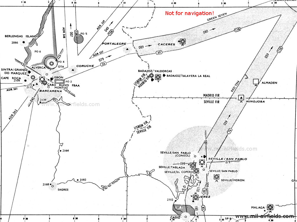
North (Source: DoD)
South (Source: DoD)
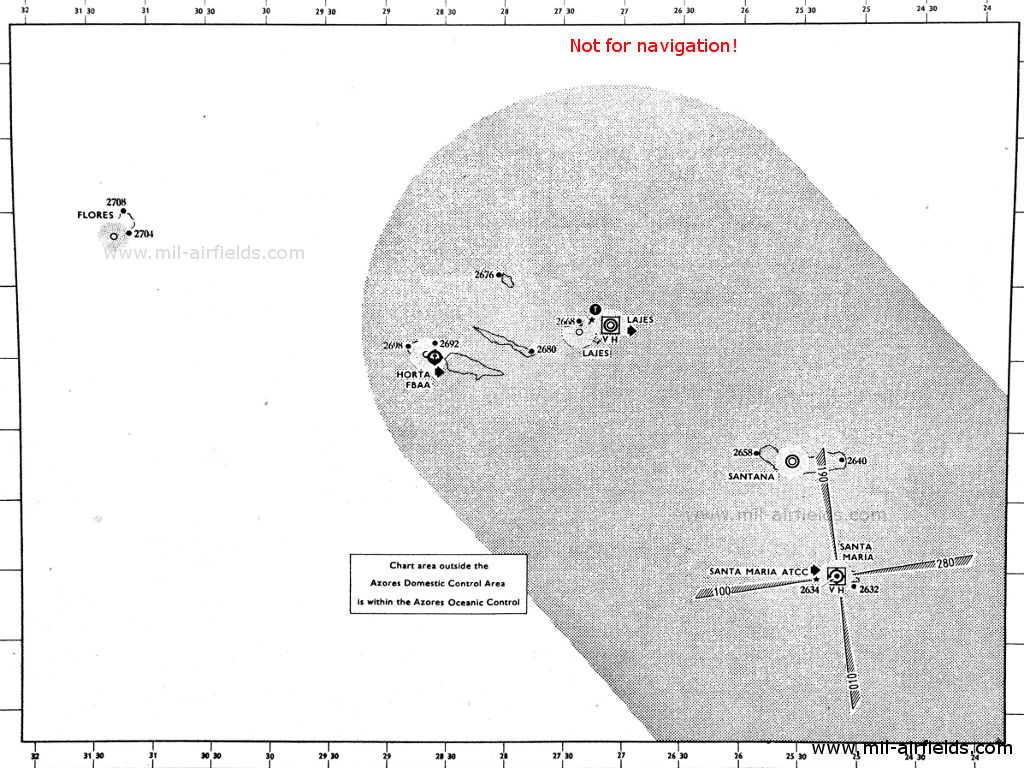
Azores (Source: DoD)
Explanations
![]()
Abbreviations
| approx. | approximately | |
| civ | civil | civil operator |
| GP | Glide path | Glide path transmitter |
| ILS | Instrument Landing System | (Approach and landing aid) |
| IM | Inner Marker | Marker beacon just in front the runway |
| kHz | Kilohertz | (Unit for frequency) |
| L | Locator | Non-directional beacon for the approach |
| LLZ | Localizer | Localizer transmitter |
| LMM | Locator Middle Marker | Combination of Middle Marker and Locator |
| LOM | Locator Outer Marker | Combination of Outer Marker and Locator |
| m | Meter | (Unit for length) |
| MHz | Megahertz | (Unit for frequency) |
| mil | military | military operator |
| MM | Middle Marker | Marker beacon |
| NDB | Non-directional beacon | Non-directional beacon on long or medium waves |
| NM | Nautical Miles | (Unit for length) |
| OM | Outer Marker | Marker beacon |
| PRMG | ПРМГ Посадочная радиомаячная группа | Soviet / russian military instrument landing system |
| RSBN | РСБН Rадиотехническая система ближней навигации | Soviet / russian military radio navigation system |
| SBA | Standard Beam Approach | Approach system, Lorenz system, predecessor of the ILS |
| THR | Threshold | Runway threshold (most often with number of runway) |
| transf. | transformed | Coordinates were converted from a different reference system, therefore there may be deviations. |
| VAR | Visual-Aural Rnange | |
| VOR | VHF Omnidirectional Radio Range | |
| W | Watt | (Unit for power) |
| WGS84 | World Geodetic System 1984 | (geospatial reference system, GPS coordinates) |
Directory
For historical information only, do not use for navigation or aviation purposes!
Alverca: Air Base
Aveiro: Airfield (São Jacinto, Aeródromo Municipal de Aveiro)
Aveiro: NDB (PNAS)
N4039 W00845 (approx.) Google Maps
AV, 291.9 kHz
N4039 W00845 (approx.) Google Maps
AV, 291.9 kHz
Operated in clear weather H+14, 44; in fog: H+02 and every 6 minutes.
Berlengas: NDB
N3925 W00930 (approx.) Google Maps
IB, 287.3 kHz
N3925 W00930 (approx.) Google Maps
IB, 287.3 kHz
Berlenga Grande. Operated in clear weather H+04, 34; in fog H+04 and every 6 minutes.
Cape Roca: NDB
N3847 W00930 (approx.) Google Maps
RC, 308 kHz
N3847 W00930 (approx.) Google Maps
RC, 308 kHz
Cabo da Roca. Operated in clear weather H+06, 36; in fog H+00 and every 6 minutes.
Coruche: NDB
N3858 W00832 (approx.) Google Maps
CR, 389 kHz
N3858 W00832 (approx.) Google Maps
CR, 389 kHz
At the intersection of airways ADR (Advisory Route) 527, ADR 548 and ADR 549.
For historical information only, do not use for navigation or aviation purposes!
Horta: Seaplane Station
Horta: NDB (civ)
N3832 W02838 (approx.) Google Maps
FY, 294.5 kHz
N3832 W02838 (approx.) Google Maps
FY, 294.5 kHz
Azores (Açores). Operated on 30 minutes request to Santa Maria.
Lajes (Base Aérea das Lajes, Base Aérea Nº 4, BA4)
Lajes: Racon (USAF)
N384456 W0270424 (approx.), 247°/0.42 NM to field Google Maps
2, 9310 MHz
N384456 W0270424 (approx.), 247°/0.42 NM to field Google Maps
2, 9310 MHz
Operated continuously.
Runway 16:
Lajes: NDB
N3846 W02707 (approx.) Google Maps
GP, 341 kHz, 400 W
N3846 W02707 (approx.) Google Maps
GP, 341 kHz, 400 W
In the early 1950s, this beacon was a Range (courses: 073°, 163°, 253° and 343°)
Runway 34:
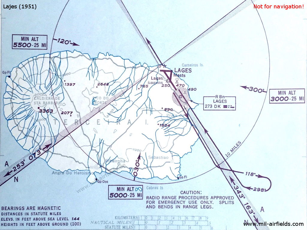
Range approach to Lajes airfield (Azores) in 1951 - The Range is located immediately to the northwest of the airfield. The four courses and the A/N sectors of the Range are depicted on the map (Source: DoD)
Leça: NDB
N4112 W00843 (approx.) Google Maps
LC, 291.9 kHz
N4112 W00843 (approx.) Google Maps
LC, 291.9 kHz
Leça da Palmeira. Operated in clear weather H+16, 46; in fog: H+04 and every 6 minutes.
Lisbon: Airport (Aeroporto de Lisboa, Aeroporto da Portela, Aeroporto Humberto Delgado)
Lisbon: Eureka
Lisbon: SBA
Runway 23:
Lisbon: Range
N3849 W00906 (approx.), 225°/3.0 NM to field Google Maps
PL, 382 kHz
N3849 W00906 (approx.), 225°/3.0 NM to field Google Maps
PL, 382 kHz
The four predefined courses to the range were 045°, 135°, 225° and 315°.
Lisbon: ILS 23
PA, 109.5 MHz
PA, 109.5 MHz
Operated on request.
Lisbon: LOM 23
225°/4.0 NM to THR 23
Locator: OL, 224 kHz
225°/4.0 NM to THR 23
Locator: OL, 224 kHz
Operated on request.
Lisbon: LMM 23
223°/0.57 NM to THR 23
Locator: L, 207 kHz
223°/0.57 NM to THR 23
Locator: L, 207 kHz
Operated on request.
Lisbon: IM 23
225°/0.03 NM to THR 23
Dots, 75 MHz
225°/0.03 NM to THR 23
Dots, 75 MHz
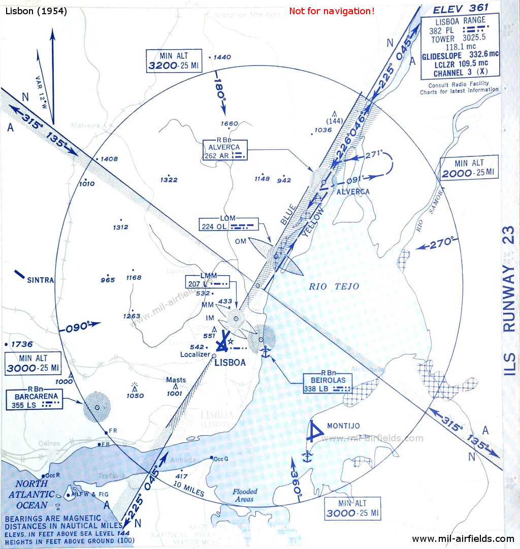
ILS approach to Lisbon runway 23 in 1954 - In the center of the circle is the Lisbon Range. (Source: DoD)
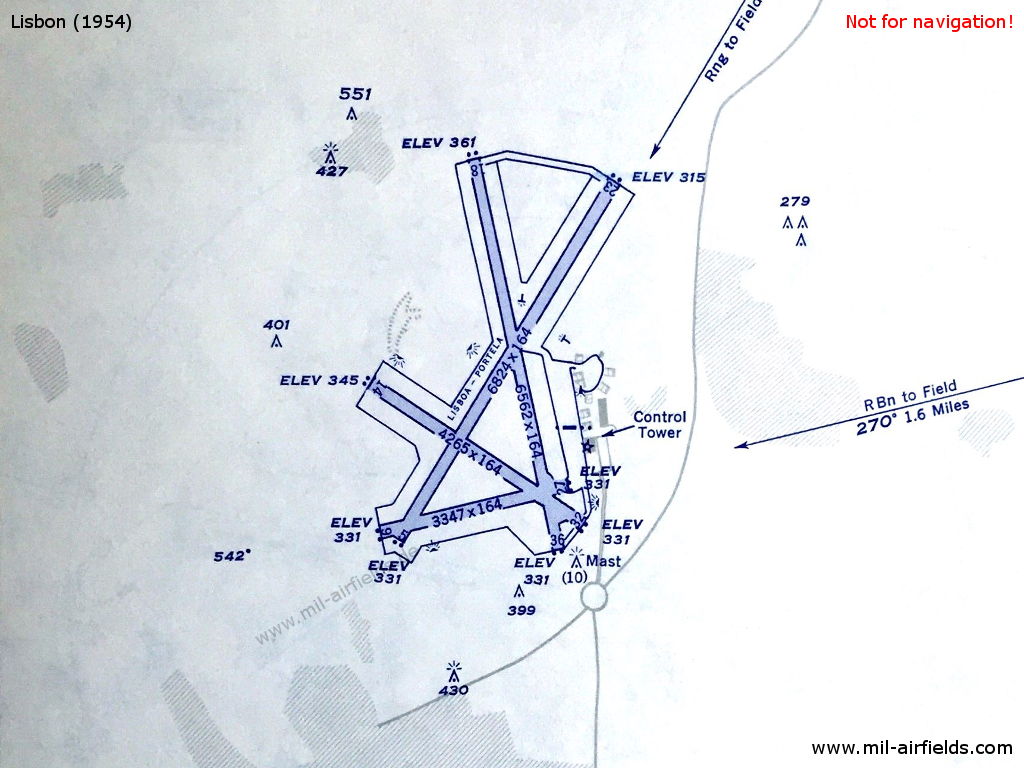
Lisbon Airport in 1954 (Source: DoD)
Mont D'Or: NDB
N4145 W00852 (approx.) Google Maps
MR, 291.9 kHz
N4145 W00852 (approx.) Google Maps
MR, 291.9 kHz
Montedor. Operated in clear weather H+12, 42; in fog: continuous.
Montijo: Air Base
For historical information only, do not use for navigation or aviation purposes!
Ota: Air Base
Porto: Airport
Runway 18:
Porto: NDB
181°/2.2 NM to field
PO, 327 kHz, 350 W
181°/2.2 NM to field
PO, 327 kHz, 350 W
Porto: ILS 18
PR, 109.5 MHz
PR, 109.5 MHz
Operated on request. On test.
Porto: MM 18
181°/0.6 NM to THR 18
Dots Dashes, 75 MHz
181°/0.6 NM to THR 18
Dots Dashes, 75 MHz
Porto: IM 18
181°/0.43 NM to THR 18
Dots, 75 MHz
181°/0.43 NM to THR 18
Dots, 75 MHz
Santa Maria: Airport
Runway 01:
Santa Maria: Range/Z Marker
N3657 W02510 (approx.) Google Maps
Range: STA, 240 kHz
Z Marker: 75 MHz
N3657 W02510 (approx.) Google Maps
Range: STA, 240 kHz
Z Marker: 75 MHz
The four predefined courses to the Range were 010°, 100°, 190° and 280°.
Runway 19:
Santa Maria: ILS 19
SM, 110.3 MHz
SM, 110.3 MHz
Santa Maria: MM 19
190°/0.61 NM to THR 19
Dots Dashes, 75 MHz
190°/0.61 NM to THR 19
Dots Dashes, 75 MHz
Santa Maria: IM 19
190°/0.04 NM to THR 19
Dots, 75 MHz
190°/0.04 NM to THR 19
Dots, 75 MHz
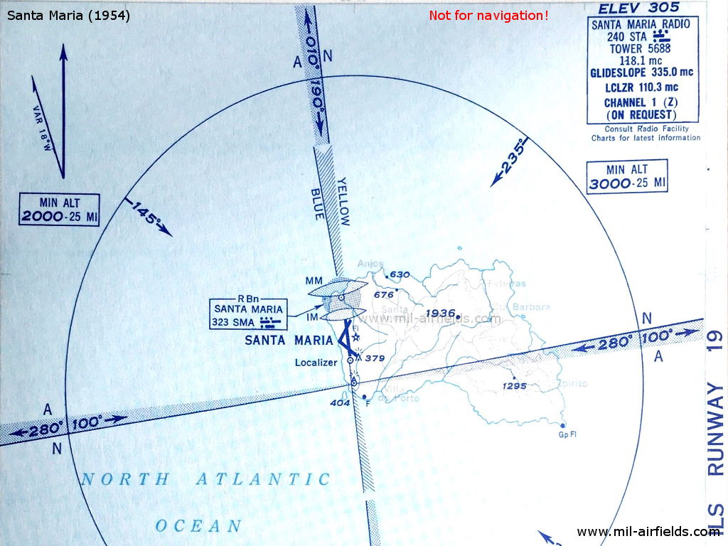
Santa Maria, Azores, 1954: ILS approach to runway 19 - South of the field is the Range with its four courses and the A/N sectors. (Source: DoD)
Santana: Airport (Aeródromo de Santana)
Santana: NDB (PAF)
N3749 W02534 (approx.) Google Maps
SML, 371 kHz, 1200 W
N3749 W02534 (approx.) Google Maps
SML, 371 kHz, 1200 W
Rabo de Peixe, Ribeira Grande, Azores (Açores).
Sintra: Air Base (Base Aérea de Sintra, Base Aérea Nº1, BA1)
For historical information only, do not use for navigation or aviation purposes!
Vilar Formoso: NDB
N4036 W00649 (approx.) Google Maps
PB, 268 kHz
N4036 W00649 (approx.) Google Maps
PB, 268 kHz
At the northern end of Advisory Route 549.
For historical information only, do not use for navigation or aviation purposes!
Recommended
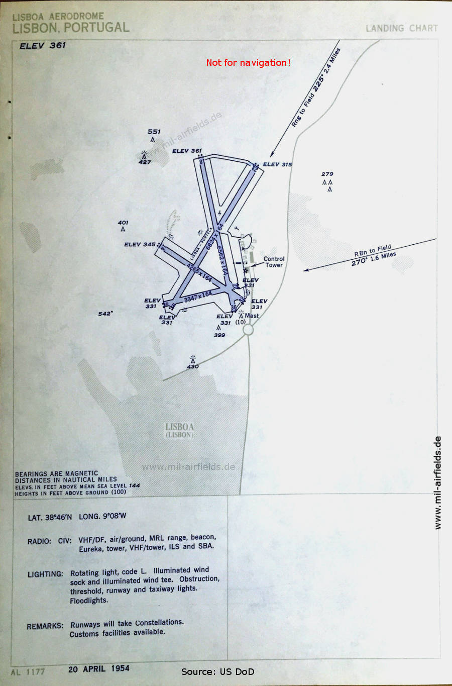
Image credits are shown on the respective target page, click on the preview to open it.