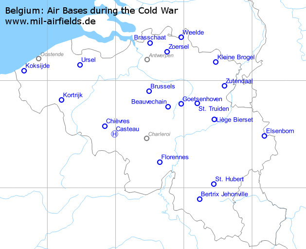
Military airfields in Belgium (23)
Short History
After WW II, Belgium was co-founder of the Western Defense Union (1946, precursor of NATO) and of NATO (1949). Within these organizations Belgium committed itself to build 15 airbases, partly for its own use and partly to provide facilities for allied forces in case of war.
The bases to be used by the Belgian Air Force (8) were: Beauvechain, Brustem, Florennes, Chievres, Koksijde and Melsbroek (all ex-Luftwaffe fields), together with 2 brand new bases: Kleine-Brogel and Bierset (Liege). The so-called reserve bases (6) are: Zutendaal, Weelde, Zoersel-Oostmalle, Ursel, Bertrix and Saint-Hubert. Intended for deployments of both BAF units and allied units.
All airfields were extended (existing bases) or newly built to NATO standards between 1950 and 1955. Runway length tobe 2400 meter with preference for an emergency parallel runway (23 meter width) of also 2400 meter. NATO minimum for the back-up runway was 2000 meter. Airfields with an existing cross runway (Chievres, Koksijde, Melsbroek) did have indeed a secondary runway of 2000 meter.
Later, between 1958 and 1961, the main runways of all bases were lengthened to 10.000 ft class (3000+ meter) with the addition of so called overruns. These overruns could be used for additional takeoff distance but in practice they were mainly used as stopway in case of emergency, when using an emergency brake system like a cable arresting gear and a net arresting system. Both type of systems were(are) used by the Belgian Air Force on active bases.
The 15th airfield was canceled before being built. It was planned at Sart-les-Saint-Vith (North of the city of Saint-Vith in the Ardennes area). But later another 15th airbase Kitona airbase was built (1957-1960) in Congo (present Democratic Republic of Congo) to house a fleet of Neptunes anti-submarine warplanes. But the sudden independence of Congo in 1960 prevented the actual use of the airbase.
(Text courtesy of Jean-Pierre Pulinx, thanks a lot!)
Arendonk: Ammunition depot helipad
Kwartier DBW Hauptmunitionsdepot (DBW = “Deutsche Bundeswehr)
For historical information only, do not use for navigation or aviation purposes!
| Coordinates | N512104 E0050702 (WGS84) Google Maps (approximate location) |
During the Cold War
Helipad at the ammunition depot of the German Armed Forces (Bundeswehr).
Airfields in the vicinity
Beauvechain: Air Base
Base aérienne de Beauvechain, Kwartier basis luitenant-kolonel vlieger Charles Roman
For historical information only, do not use for navigation or aviation purposes!
| Coordinates | N504526 E0044560 (WGS84) Google Maps |
| Elevation | 363 ft |
| Location indicator | EBBE |
In the 1980s and early 1990s
Runways
Data for the year 1990:
- 04L/22R: 3074 m x 45 m Asphalt/Concrete
- 04R/22L: 2377 m x 22 m
Radio beacons
Data for the year 1990:
- TACAN: CH107 "BBE", am Platz
Airfields in the vicinity
- 078°/14km Goetsenhoven: Airfield (Gossoncourt, Tienen, Tirlemont, Kwartier basis 1ste luitenant de Bersacques)
- 309°/25km Brussels: Airport (National, Zaventem, Melsbroek, Luchthaven Brussel-Nationaal, Aéroport Bruxelles-National)
- 300°/28km Brussels: Airfield: Evere (L'aérodrome de Bruxelles Haren-Evere)
- 083°/30km St. Truiden: Airfield (Bevingen, Sint Truiden, Brustem, Vliegbasis Sint-Truiden, Kwartier/vliegbasis adjudant kandidaat reserveonderluitenant Barbanson)
- 238°/34km Nivelles: Airfield
Bertrix Jehonville: Airfield
For historical information only, do not use for navigation or aviation purposes!
| Coordinates | N495330 E0051340 (WGS84) Google Maps |
| Elevation | 1514 ft |
| Location indicator | EBBX |
In the 1980s and early 1990s
Runways
- 06/24: 2400 m x 45 m Concrete
Airfields in the vicinity
Brasschaat: Airfield
Kwartier Brasschaat Noord
For historical information only, do not use for navigation or aviation purposes!
| Coordinates | N512040 E0043009 (WGS84) Google Maps |
| Elevation | 76 ft |
| Location indicator | EBAT |
During the Cold War
Use
Beglian army aviation airfield.
Airfields in the vicinity
Brussels: Airfield Evere
L'aérodrome de Bruxelles Haren-Evere
For historical information only, do not use for navigation or aviation purposes!
Airfields in the vicinity
Brussels: Airport
National, Zaventem, Melsbroek, Luchthaven Brussel-Nationaal, Aéroport Bruxelles-National
For historical information only, do not use for navigation or aviation purposes!
| Coordinates | N505358 E0042923 (WGS84) Google Maps |
| Location indicator | EBBR, EBMB |
During the Cold War
Use
Airport with military use.
In the 1980s and early 1990s
Runways
Data for the year 1990:
- 02/20: 2984 m x 50 m Concrete/Asphalt
- 07L/25R: 3638 m x 45 m Asphalt
- 07R/25L: 3211 m x 45 m Concrete/Asphalt
Airfields in the vicinity
Casteau: SHAPE Pad
Mons, Camp Casteau, Quartier sous-lieutenant Vilain
For historical information only, do not use for navigation or aviation purposes!
| Coordinates | N503011 E0035857 (WGS84) Google Maps |
| Elevation | 299 ft |
| Location indicator | EBCH |
Airfields in the vicinity
Chièvres: Air Base
Base aérienne de Chièvres, Caserne Daumerie
For historical information only, do not use for navigation or aviation purposes!
| Coordinates | N503436 E0035019 (WGS84) Google Maps |
| Elevation | 201 ft |
| Location indicator | EBCV |
In the 1980s and early 1990s
Runways
Data for the year 1990:
- 08/26: 2497 m x 50 m Asphalt/Concrete
- 02/20 closed
Radio beacons
Data for the year 1990:
- TACAN: CH79 "CIV", at field
- VOR: 113.2 "CIV", at field
- ILS26: 108.55 "ICV"
Airfields in the vicinity
Elsenborn: Airfield
Butgenbach, Bütgenbach, Rauhe Knipp, Kamp Elsenborn
For historical information only, do not use for navigation or aviation purposes!
| Coordinates | N502905 E0061059 (WGS84) Google Maps |
| Elevation | 1830 ft |
Location
Airfields in the vicinity
Florennes: Air Base
Base aérienne de Florennes, Quartier base Offenbach
For historical information only, do not use for navigation or aviation purposes!
| Coordinates | N501426 E0043849 (WGS84) Google Maps |
| Elevation | 935 ft |
| Location indicator | EBFS |
In the 1980s and early 1990s
Runways
Data for the year 1990:
- 08/26: 3384 m x 45 m Asphalt
- 08R/26L: 1800 m x 50 m closed
Radio beacons
Data for the year 1990:
- TACAN: CH52 "BFS", at field
- ILS26: 108.35 "IBFS"
Goetsenhoven: Airfield
Gossoncourt, Tienen, Tirlemont, Kwartier basis 1ste luitenant de Bersacques
For historical information only, do not use for navigation or aviation purposes!
| Coordinates | N504654 E0045728 (WGS84) Google Maps |
| Elevation | 230 ft |
| Location indicator | EBTN |
In the 1970s
Radio beacons
Data for the year 1978:
In the 1980s and early 1990s
Runways
Data for the year 1990:
- 06/24: 720 m x 30 m
- 17/35: 780 m x 30 m
Airfields in the vicinity
- 259°/14km Beauvechain: Air Base (Base aérienne de Beauvechain, Kwartier basis luitenant-kolonel vlieger Charles Roman)
- 087°/17km St. Truiden: Airfield (Bevingen, Sint Truiden, Brustem, Vliegbasis Sint-Truiden, Kwartier/vliegbasis adjudant kandidaat reserveonderluitenant Barbanson)
- 292°/35km Brussels: Airport (National, Zaventem, Melsbroek, Luchthaven Brussel-Nationaal, Aéroport Bruxelles-National)
- 115°/38km Liège Bierset: Airfield (Base aérienne de Bierset, Aéroport de Liège, Base aérienne et caserne De Cubber)
- 287°/39km Brussels: Airfield: Evere (L'aérodrome de Bruxelles Haren-Evere)
Kleine Brogel: Air Base
Vliegbasis Kleine-Brogel, Base aérienne de Kleine-Brogel, Basis generaal-majoor vlieger graaf Ivan du Monceau de Bergendal
For historical information only, do not use for navigation or aviation purposes!
| Coordinates | N511006 E0052810 (WGS84) Google Maps |
| Elevation | 199 ft |
| Location indicator | EBBL |
During the Cold War
Usage during the Cold War
Belgian Airforce airbase.
In the 1980s and early 1990s
Runways
Data for the year 1990:
- 05/23: 3096 m x 45 m Asphalt
Radio beacons
Data for the year 1990:
- NDB: 448.5 "ONT", 231° 3.5NM to field
- TACAN: CH35 "BBL", at field
Today
Use today
Belgian Airforce airbase.
Airfields in the vicinity
Knokke-Heist: Airfield
Knokke-Zoute
For historical information only, do not use for navigation or aviation purposes!
Koksijde: Air Base
Vliegbasis Koksijde, Vliegbasis adjudent vlieger Frans Allaeys
For historical information only, do not use for navigation or aviation purposes!
| Coordinates | N510522 E0023923 (WGS84) Google Maps |
| Elevation | 20 ft |
| Location indicator | EBFN |
In the 1970s
Radio beacons
Data for the year 1978:
- NDB: 325.5 "KOK"
- VORTAC: 114.5 CH92 "KOK"
In the 1980s and early 1990s
Runways
Data for the year 1990:
- 02/20: 2016 m x 52 m Asphalt
- 11/29: 2678 m x 50 m Asphalt/Concrete
Radio beacons
Data for the year 1990:
- DVOR: 114.5 "KOK", at field
- TACAN: CH92 "KOK", at field
Kortrijk: Airfield
Luchthaven Kortrijk-Wevelgem
For historical information only, do not use for navigation or aviation purposes!
| Coordinates | N504906 E0031228 (WGS84) Google Maps |
| Location indicator | EBKT |
During the Cold War
Use
Airfield of the Belgian Air Force until the 1960s.
Liège Bierset: Airfield
Base aérienne de Bierset, Aéroport de Liège, Base aérienne et caserne De Cubber
For historical information only, do not use for navigation or aviation purposes!
| Coordinates | N503817 E0052643 (WGS84) Google Maps |
| Elevation | 658 ft |
| Location indicator | EBLH, EBLG |
In the 1980s and early 1990s
Runways
Data for the year 1990:
- 05R/23L: 3286 m x 45 m Asphalt/Beton
- 05L/23R: 2272 m x 23 m primary use as TWY
- 05/23 Gras emergency
Radio beacons
Data for the year 1990:
- TACAN: CH31 "BLG"
- ILS23L: 110.5 "ILG"
- LOM23L: 290 "ONL"
- LMM23L: 348.5 "LG"
Airfields in the vicinity
Nivelles: Airfield
For historical information only, do not use for navigation or aviation purposes!
St. Hubert: Airfield
For historical information only, do not use for navigation or aviation purposes!
| Coordinates | N500201 E0052617 (WGS84) Google Maps |
| Elevation | 1930 ft |
| Location indicator | EBSU |
Airfields in the vicinity
St. Truiden: Airfield
Bevingen, Sint Truiden, Brustem, Vliegbasis Sint-Truiden, Kwartier/vliegbasis adjudant kandidaat reserveonderluitenant Barbanson
For historical information only, do not use for navigation or aviation purposes!
| Coordinates | N504717 E0051133 (WGS84) Google Maps |
| Elevation | 246 ft |
| Location indicator | EBST |
In the 1970s
Runways
Data for the year 1973:
- 06/24: 2368 m x 50 m
- 10/28: 1435 m x 20 m
In the 1980s and early 1990s
Runways
Data for the year 1990:
- 06/24: 2993 m x 50 m Asphalt
Radio beacons
Data for the year 1990:
- NDB: 510 "ST", 068° 1.4NM to field
- TACAN: CH33 "BVG", at field
Airfields in the vicinity
Ursel: Airfield
For historical information only, do not use for navigation or aviation purposes!
| Coordinates | N510839 E0032827 (WGS84) Google Maps |
| Elevation | 95 ft |
| Location indicator | EBUL |
During the Cold War
Runways
- 07/25: 2430 m x 45 m Concrete
Airfields in the vicinity
Weelde: Airfield
For historical information only, do not use for navigation or aviation purposes!
| Coordinates | N512342 E0045736 (WGS84) Google Maps |
| Elevation | 105 ft |
| Location indicator | EBWE |
During the Cold War
Usage during the Cold War
Reserve airfield.
Runways
- 07/25: 2980 m x 45 m Concrete
Airfields in the vicinity
Zoersel: Airfield
For historical information only, do not use for navigation or aviation purposes!
| Coordinates | N511553 E0044517 (WGS84) Google Maps |
| Elevation | 53 ft |
| Location indicator | EBZR |
During the Cold War
Usage during the Cold War
Reserve airfield.
Runways
- 05/23: 2980 m x 45 m Concrete
Airfields in the vicinity
Zutendaal: Air Base
Vliegbasis Zutendaal
For historical information only, do not use for navigation or aviation purposes!
| Coordinates | N505656 E0053531 (WGS84) Google Maps |
| Elevation | 312 ft |
| Location indicator | EBSL |
During the Cold War
Usage during the Cold War
Reserve airfield
Runways
- 06/24: 2980 m x 45 m Asphalt
Today
Use today
Military Storage Site
Airfields in the vicinity