Sweden: Air Bases and Military Airfields
Militära flygplatser i Sverige
For historical information only, do not use for navigation or aviation purposes!
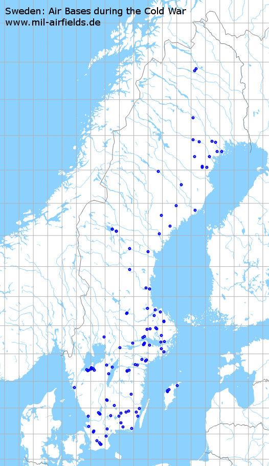
Distribution of the airfields
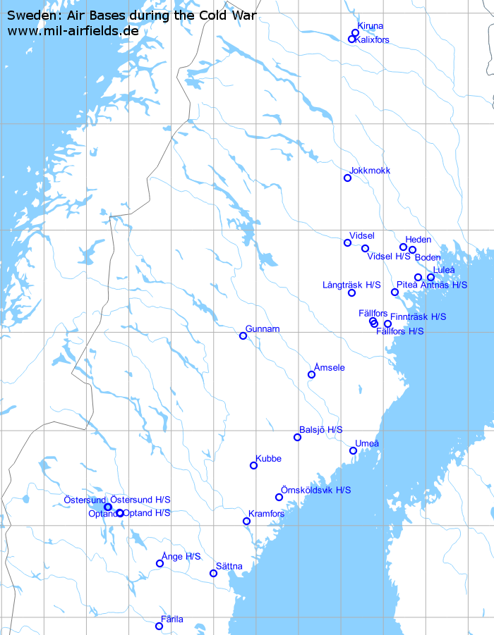
Northern Part (H/S = Highway Strip)

Southern Part (Attention: not all airfield labels are shown)
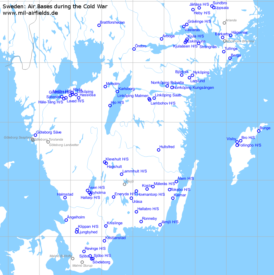
South enlarged
Military airfields in Sweden (106)
Ålem: Highway Strip / Reservvägbas
For historical information only, do not use for navigation or aviation purposes!
| Coordinates | N565831 E0162357 (WGS84) Google Maps |
Location of airfield
E22, 2 km north-northeast of Ålem.
Runways
- 02/20: 2000 m
Installations
This highway strip has a full QRA area (Framom) in the south. Maybe it comes from the history as war airfield.
Possibly in the area of a former airfield. It has a readiness area in the north and in the south. The northern area is no longer connected to the motorway.
Airfields in the vicinity
- 221°/21km Tokebo: Highway Strip / Reservvägbas
Categories
Highway Strips WorldwideÄlvkarleby: Highway Strip / Reservvägbas
For historical information only, do not use for navigation or aviation purposes!
| Coordinates | N603305 E0172958 (WGS84) Google Maps |
| Airfield Id | S 81 |
Location of airfield
3 km southeast of Älvkarleby on road 76.
Runways
- 11/29: 2000 m
Airfields in the vicinity
- 115°/20km Skärplinge: Highway Strip / Reservvägbas
Categories
Highway Strips WorldwideÅmsele: Airfield
Amsele
For historical information only, do not use for navigation or aviation purposes!
| Coordinates | N643415 E0191852 (WGS84) Google Maps |
| Elevation | 695' |
| Location indicator | ESUA |
Location of airfield
4 km north-northwest of Åmsele.
Usage during the Cold War
Military airfield, not activated permanently.
Runways
- 15/33: 2000 m Asphalt Main runway
- 16/34: 1200 m Highway strip, parallel to the runway on the western side.
- 18/36: 1200 m Highway strip, ca. 1,5 km to the east
- 15/33: 1200 m Highway strip, ca. 2 km to the north.
Installations
Simple layout: runway, QRA areas (Framom) at each end; 3 highway strips in the vicinity.
Links
- Flygkartan.se - Aerial picture
- bunkertours.se - Pictures
Ånge: Highway Strip / Reservvägbas
Granboda, Ange, Jämtkrogen
For historical information only, do not use for navigation or aviation purposes!
| Coordinates | N623514 E0154317 (WGS84) Google Maps |
Location of airfield
E14, 8 km north-northeast of Ånge.
Runways
- 14/32: 2500 m
Categories
Highway Strips WorldwideÄngelholm: Airport
Barkåkra, Angelholm Barkakra
For historical information only, do not use for navigation or aviation purposes!
| Coordinates | N561730 E0125117 (WGS84) Google Maps |
| Elevation | 65' |
| Location indicator | ESDB, ESTA |
| Airfield Id | F 10 |
Location of airfield
5 km north of Ängelholm.
Runways
Data for the year 1990:
- 14/32: 1950 m x 40 m Asphalt
- 04/22: 2000 m x 40 m Asphalt
Radio beacons
- NDB: 370.5 "LB"
- ILS 14: 111.3 "DB"
Data for the year 1990:
Radar
PAR (1971)
Antnäs: Highway Strip / Reservvägbas
For historical information only, do not use for navigation or aviation purposes!
| Coordinates | N653232 E0214932 (WGS84) Google Maps |
Location of airfield
E4, southwest of Antnäs.
Runways
- 05/23: 2000 m
Airfields in the vicinity
- 089°/14km Luleå: Kallax
- 348°/30km Boden: Airfield
- 239°/31km Piteå: Airfield (Pitea)
- 334°/37km Heden: Airfield (Boden/Heden)
Categories
Highway Strips WorldwideArboga: Airfield
Flygplats
For historical information only, do not use for navigation or aviation purposes!
| Coordinates | N592318 E0155516 (WGS84) Google Maps |
| Elevation | 33' |
| Location indicator | ESQO |
Location of airfield
3 km east of Arboga.
Usage during the Cold War
Swedish airforce airfield.
Use today
Private airfield.
Runways
Data for the year 1990:
- 15/33: 2000 m x 40 m Asphalt
Åsen: Highway Strip / Reservvägbas
Byholma-2, Asen
For historical information only, do not use for navigation or aviation purposes!
| Coordinates | N564902 E0133230 (WGS84) Google Maps |
Location of airfield
Approx. 5 km northwest of Byholma airfield.
Use today
This highway strip is probably not intended for use anymore, as the parking pads on both sides have been demolished and renaturated.
Runways
- 12/30: 1200 m
Airfields in the vicinity
- 136°/5km Byholma: Airfield (Flygbas)
- 139°/9km Hallarp: Highway Strip / Reservvägbas (Byholma-1)
Categories
Highway Strips WorldwideBalsjö: Highway Strip / Reservvägbas
For historical information only, do not use for navigation or aviation purposes!
| Coordinates | N635559 E0185804 (WGS84) Google Maps |
Location
65 km west-northwest of Umeå, 12 km east of Bjurholm.
Location of airfield
On road 92.
Runways
- 10/28: 2300 m
Categories
Highway Strips WorldwideBarkarby: Airfield
Stockholm-Barkarby
For historical information only, do not use for navigation or aviation purposes!
| Coordinates | N592451 E0175252 (WGS84) Google Maps |
| Elevation | 56' |
| Location indicator | ESCI, ESKB |
| Airfield Id | F 8 |
Location of airfield
8 NM NW Stockholm
Use today
Closed.
Runways
Data for the year 1990:
- 06/24: 2000 m x 40 m Asphalt
Installations
Underground hangar.
Links
- flygbas.se - Aerial picture
- Aerial picture 05/2001
- Aerial picture 2007
Airfields in the vicinity
- 076°/15km Hägernas: Seaplane Base
Berga: Heliport
For historical information only, do not use for navigation or aviation purposes!
| Coordinates | N590413 E0180660 (WGS84) Google Maps |
| Location indicator | ESQP |
Usage during the Cold War
Heliport.
Use today
Closed.
Airfields in the vicinity
- 316°/17km Tullinge: Airfield
Björkvik: Airfield
Bjorkvik
For historical information only, do not use for navigation or aviation purposes!
| Coordinates | N584727 E0163415 (WGS84) Google Maps |
| Elevation | 148' |
| Location indicator | ESKX |
Location of airfield
Ca. 5 km south-southeast of Björkvik.
Runways
Data for the year 1990:
- 12/30: 2000 m
Installations
Simple layout: runway, taxiway, QRA areas (Framom) at each end.
Airfields in the vicinity
Boden: Airfield
For historical information only, do not use for navigation or aviation purposes!
| Coordinates | N654837 E0214131 (WGS84) Google Maps |
| Elevation | 56' |
| Location indicator | ESPG |
Location of airfield
1 NM S Boden
Runways
- 14/32: 400 m x 30 m Asphalt
Airfields in the vicinity
- 287°/11km Heden: Airfield (Boden/Heden)
- 168°/30km Antnäs: Highway Strip / Reservvägbas
- 146°/36km Luleå: Kallax
Borlänge: Airfield
Borlange, Rommehed, Falun
For historical information only, do not use for navigation or aviation purposes!
| Coordinates | N602519 E0153056 (WGS84) Google Maps |
| Elevation | 503' |
| Location indicator | ESCS, ESSD |
Location of airfield
8.5 km south-southeast of Borlänge.
Runways
- 14/32: 2312 m x 40 m Asphalt Main runway
- 14/32 (Bana C): 1200 m Short Strip (Kortbana) southeast of main runway
Radio beacons
Data for the year 1971:
- VOR: 116.8 "BOR", at field
- NDB: 324 "OB", 314°/2.26NM to fld
Data for the year 1990:
- VORDME: 117.6 "BOR", at field
- ILS 32: 109.5 "SD"
Installations
Simple layout with runway, QRA areas at both ends and taxiway. About 1 km southeast of the airfield is a short runway (Kortbana) which is connected by a taxiway/road. A highway strip is located northeast of the field on road 70. Along the roads around the airfeld are about 20 paved parking pads for aircraft. All installations are stretching over a length of 7 km.
Links
- Flygbas.se - Short description
- UL-BOLAGET - Airfield map from 2001. Right at the bottom, an arrow points to the "MIL RWY". Also the highway strip northeast of the runway is marked by a black line.
Airfields in the vicinity
Borlänge: Highway Strip / Reservvägbas
For historical information only, do not use for navigation or aviation purposes!
| Coordinates | N602549 E0153127 (WGS84) Google Maps |
General
Highway Strip/Short Strip/Kortbana on road 70
Runways
- 14/32: 1200 m
Airfields in the vicinity
Categories
Highway Strips WorldwideBrattforsheden: Airfield
Krigsflygfält 16
For historical information only, do not use for navigation or aviation purposes!
| Coordinates | N593633 E0135451 (WGS84) Google Maps |
| Elevation | 588 ft |
| Location indicator | ESQS, ESSM |
Usage during the Cold War
Swedish Air Force airfield (ESQS, known for the 1960s).
Runways
Data for the year 1990:
- ../..: 800 m
Links
- Krigsflygfält 16 - Airfield history
Bro: Highway Strip / Reservvägbas
For historical information only, do not use for navigation or aviation purposes!
| Coordinates | N574101 E0182718 (WGS84) Google Maps |
Location
Gotland
Location of airfield
6 km east-northeast of Visby airport.
Runways
- 15/33: 2200 m
Airfields in the vicinity
- 250°/7km Visby: Airfield
- 218°/11km Follingbo: Highway Strip / Reservvägbas
- 062°/39km Bunge: Airfield (Flygfält)
Categories
Highway Strips WorldwideBunge: Airfield
Flygfält
For historical information only, do not use for navigation or aviation purposes!
| Coordinates | N575057 E0190206 (WGS84) Google Maps |
| Location indicator | ESVB |
Location
Gotland
Location of airfield
1,5 km southwest of Fårösund
Use today
General aviation.
Links
- Bunge flygfält - Homepage
- Gotlands Militärhistoria - Description and pictures
Airfields in the vicinity
- 242°/39km Bro: Highway Strip / Reservvägbas
Byholma: Airfield
Flygbas
For historical information only, do not use for navigation or aviation purposes!
| Coordinates | N564702 E0133603 (WGS84) Google Maps |
| Location indicator | ESFY |
Use today
Closed, now used as timber storage.
Runways
Angaben für das Jahr 1990:
- 12/30: 2300 m
Installations
Simple Layout with runway, taxiway und QRA areas (Framom) at both runway ends. A remote dispersal area is about 1 km southwest, west of road 545. There are two highway strips in the vicinity of the airfield: 5 km to the northwest Åsen: Highway Strip / Reservvägbas and 4 km south-southeast Hallarp: Highway Strip / Reservvägbas. Along road 545 between the airfield and Åsen are (were) several paved parking pads. All installations are strechting over a length of 12 km.
Links
- Aerial picture 08/2004 - still without the timber storage
- RolfsBild - Timber storage at former Byholma airfield
- Byholma - World largest timber storage
- Byholma timmerupplag
- bunkertours.se - Pictures of the airfield
Airfields in the vicinity
Eneryda: Highway Strip / Reservvägbas
For historical information only, do not use for navigation or aviation purposes!
| Coordinates | N564210 E0142260 (WGS84) Google Maps |
Location of airfield
2 km east of Eneryda.
Runways
- 08/26: 2000 m
Airfields in the vicinity
- 094°/34km Uråsa: Airfield (Urasa, Växjö, Vaxjo)
Categories
Highway Strips WorldwideEskilstuna: Airfield
For historical information only, do not use for navigation or aviation purposes!
| Coordinates | N592112 E0164230 (WGS84) Google Maps |
| Elevation | 132' |
| Location indicator | ESSU (1990) |
Location of airfield
11 km east of Eskiltuna.
Usage during the Cold War
Swedish airforce airfield.
Use today
Civil airfield.
Runways
Data for the year 1990:
- 18/36: 2200 m x 35 m Asphalt/Concrete
Radio beacons
Data for the year 1990:
- LLZ36: 110.9 "SU"
- L 36: 402 "LX"
Installations
Simple Layout with runway, taxiway and QRA areas (Framom) at each end. About 2 km southwest is Kjulaåsen highway strip / Reservvägbas with dispersal areas further to the south. 3 km to the northeast is Kjula Highway Strip / Reservvägbas. Along the road between Kjulaåsen Highway Strip and Kjula Highway Strip are several paved parking pads for aircraft. All installations are stretching over a length of 10 km.
Maybe also autobahn E20 about 3 km northeast of the airfield was intended for aircraft operations.
Links
Airfields in the vicinity
Fällfors: Airfield
Fallfors
For historical information only, do not use for navigation or aviation purposes!
| Coordinates | N650627 E0204541 (WGS84) Google Maps |
| Elevation | 640' |
| Location indicator | ESUF (1990) |
Location of airfield
2.5 km south-southwest of Fällfors.
Use today
Closed, used for car races.
Runways
Data for the year 1990:
- 16/34: 2000 m
- 14/32: 1000 m "Bana B", north of main runway.
- 16/34: 1200 m "Bana C" on the (nearly) parallel taxiway, west of the main runway
- 16/34: 1100 m "Bana D", Highway strip south-southeast of the airfield, see Fällfors Highway Strip
Installations
Simple layout: runway, taxiway, QRA areas (Framom) at each end; Three short strips / highway strips. Dispersal area about 4 km south of the airfield with paved parking pads and hangars along public roads. All installations of the airfield are stretching over a length of 11 km.
Links
- AlfaPower - Discussion forum about cars, shows map of the airfield with designators
- bunkertours.se - Pictures of the airfield and underground hangar
Airfields in the vicinity
- 159°/3km Fällfors: Highway Strip / Reservvägbas
- 100°/17km Finnträsk: Highway Strip / Reservvägbas
Fällfors: Highway Strip / Reservvägbas
For historical information only, do not use for navigation or aviation purposes!
| Coordinates | N650509 E0204652 (WGS84) Google Maps |
Airfields in the vicinity
- 339°/3km Fällfors: Airfield (Fallfors)
- 092°/15km Finnträsk: Highway Strip / Reservvägbas
Categories
Highway Strips WorldwideFärila: Airfield
Farila
For historical information only, do not use for navigation or aviation purposes!
| Coordinates | N615353 E0154217 (WGS84) Google Maps |
| Elevation | 675' |
| Location indicator | ESNF |
Location of airfield
13 km north-northwest of Färila.
Use today
Closed.
Runways
Data for the year 1990:
- 12/30: 2000 m
- 10/28: 1100 m "Bana B", ca. 3 km northwest of the airfield
- 10/28: 1100 m "Bana C", east-southeast of the airfield
- 17/35: 1200 m "Bana D", ca. 5 km southeast of the airfield
Installations
Simple layout: runway, taxiway, QRA areas (Framom) at each end. Three short strips in the vicinity, connected to the airfield by roads.
Links
- http://www.fht.nu/se/37/var/dfolderID/11 - Försvarets Historiska Telesamlingar (FHT) - Flygbassystem 90 The title of the pdf document "Flygbassystem 90" shows a map of the Färila airfield with the short strips / highway strips. But the location of "Bana B" differs significantly from current satellite pictures. On the map, it is shown north of the main runway, while satellite pictures show it more to the west.
- bunkertours.se - Pictures
Finnträsk: Highway Strip / Reservvägbas
For historical information only, do not use for navigation or aviation purposes!
| Coordinates | N650450 E0210641 (WGS84) Google Maps |
Location of airfield
3 k southeast of Finnträsk.
Runways
- 14/32: 2200 m
Airfields in the vicinity
- 272°/15km Fällfors: Highway Strip / Reservvägbas
- 281°/17km Fällfors: Airfield (Fallfors)
- 011°/36km Piteå: Airfield (Pitea)
Categories
Highway Strips WorldwideFollingbo: Highway Strip / Reservvägbas
For historical information only, do not use for navigation or aviation purposes!
| Coordinates | N573627 E0182035 (WGS84) Google Maps |
Location of airfield
4 km southeast of Visby.
Runways
- 15/33: 2200 m
Links
- Gotlands Militärhistoria - Pictures
Airfields in the vicinity
- 002°/6km Visby: Airfield
- 038°/11km Bro: Highway Strip / Reservvägbas
Categories
Highway Strips WorldwideGävle: Airfield
Sandviken
For historical information only, do not use for navigation or aviation purposes!
| Coordinates | N603536 E0165705 (WGS84) Google Maps |
| Elevation | 222' |
| Location indicator | ESSK |
Location of airfield
14 km southwest of Gävle.
Use today
General aviation.
Runways
Data for the year 1990:
- 18/36: 2000 m x 45 m Asphalt
Radio beacons
Data for the year 1990:
- LOM 18: 326 "OG"
- ILS 18: 111.3 "SK"
- LMM 18: 258.5 "R"
Links
- Aerial picture 1997 - on approach, with lights
Gillstad: Highway Strip / Reservvägbas
For historical information only, do not use for navigation or aviation purposes!
| Coordinates | N582713 E0125927 (WGS84) Google Maps |
Location of airfield
6 km southwest of Råda airfield.
Runways
- 06/24: 1200 m
Airfields in the vicinity
- 065°/4km Mellby: Highway Strip / Reservvägbas
- 036°/6km Råda: Airfield (Flygbas)
- 241°/9km Lavad: Highway Strip / Reservvägbas
- 083°/11km Lidköping: Airfield (Lidkoping, Ekcarden, Hovby)
- 242°/14km Håle-Täng: Highway Strip / Reservvägbas
- 261°/16km Såtenäs: Airfield
- 107°/17km Hasslösa: Airfield
Categories
Highway Strips WorldwideGimo: Airfield
For historical information only, do not use for navigation or aviation purposes!
| Coordinates | N600758 E0180618 (WGS84) Google Maps |
| Elevation | 60' |
| Location indicator | ESKA (1990) |
Location of airfield
6 km southwest of Gimo.
Use today
Closed.
Runways
Data for the year 1990:
- 05/23: 2000 m
Installations
Simple layout: runway, taxiway, QRA areas (Framom) at each end (see pattern ). 3 km north is Gimo: Highway Strip / Reservvägbas.
Airfields in the vicinity
- 006°/4km Gimo: Highway Strip / Reservvägbas
Gimo: Highway Strip / Reservvägbas
For historical information only, do not use for navigation or aviation purposes!
| Coordinates | N600952 E0180641 (WGS84) Google Maps |
Location of airfield
3 km west of Gimo, 3 km north of Gimo: Airfield.
Runways
- 09/27: 2400 m
Links
- hitta.se - Map and satellite picture
Airfields in the vicinity
- 186°/4km Gimo: Airfield
Categories
Highway Strips WorldwideGöteborg: Säve Airfield
Gothenburg
For historical information only, do not use for navigation or aviation purposes!
| Coordinates | N574633 E0115214 (WGS84) Google Maps |
| Elevation | 66' |
| Location indicator | ESIC, ESGP |
Runways
Data for the year 1990:
- 01/19: 1925 m x 40 m Asphalt
- 04/22: 1700 m x 30 m Asphalt
Radio beacons
Data for the year 1990:
- L: 360 "OS"
- ILS19: 108.1 "GP"
Installations
Underground hangar, now museum.
Links
- Aeroseum - Museum in underground hangar
- Aerial picture 08/2005
- Säve new underground hangar - Pictures
- Säve old underground hangar - Pictures
Grävlinge: Highway Strip / Reservvägbas
For historical information only, do not use for navigation or aviation purposes!
| Coordinates | N593728 E0164350 (WGS84) Google Maps |
Location of airfield
6 km nordeast of Västerås: Hässlö Airfield.
Runways
- 09/27: 1200 m
Airfields in the vicinity
- 235°/7km Västerås: Hässlö Airfield (Flygbas Stockholm-Vasteras, Hasslo)
- 180°/27km Kjula: Highway Strip / Reservvägbas (Barva)
- 022°/29km Heby: Highway Strip / Reservvägbas
- 182°/30km Eskilstuna: Airfield
- 185°/33km Kjulaåsen: Highway Strip / Reservvägbas
- 036°/37km Järlåsa: Highway Strip / Reservvägbas
- 148°/41km Strängnäs: Airfield
Categories
Highway Strips WorldwideGunnarn: Airfield
Flygbas, Storumans flyplats
For historical information only, do not use for navigation or aviation purposes!
| Coordinates | N645739 E0174147 (WGS84) Google Maps |
| Elevation | 915' |
| Location indicator | ESPD, ESUD |
Location of airfield
5 km south of Gunnarn.
Usage during the Cold War
Military airfield, not activated permanently.
Use today
General aviation.
Runways
- 15/33: 2300 m x 40 m Asphalt/Concrete Main runway
- 10/28: 1200 m Highway strip "Bana B", west of the airfield
- 14/32: 1200 m Highway strip "Bana C", 5 km east-southeast of the airfield
- 11/29: 1200 m Highway strip "Bana D", 6 km southeast of the airfield
Radio beacons
Data for the year 1990:
- NDB: 348 "GUN", 331°/3.4NM to fld
Installations
Simple layout with runway, taxiway and QRA areas at each end (see pattern ); three highway strip in the vicinity of the airfield.
Links
- http://www.youtube.com/watch?v=zY3gHOFgWOI - Driving around the airfield in the east, about 6 km southeast of the actual airfield. At 3:10 the beginning of the eastern short strip Kort Bana "D" is visible, at 3:45 the western end. Part 1
- http://www.youtube.com/watch?v=FNCbhV1UGuQ - Part 2
- http://www.youtube.com/watch?v=P2Fov9cMPEQ - Part 3
- bunkertours.se - Pictures
Hägernas: Seaplane Base
For historical information only, do not use for navigation or aviation purposes!
| Coordinates | N592643 E0180805 (WGS84) Google Maps |
| Location indicator | ESCE |
Radio beacons
- NDB HERON: 534 "SLB", at the seaplane base
Airspace and procedures
Unusable in winter due to ice.
Use today
Closed.
Airfields in the vicinity
- 257°/15km Barkarby: Airfield (Stockholm-Barkarby)
Hagshult: Airfield
Flygbas
For historical information only, do not use for navigation or aviation purposes!
| Coordinates | N571733 E0140815 (WGS84) Google Maps |
| Elevation | 554' |
| Location indicator | ESMV (1990) |
Usage during the Cold War
Swedish Airforce airfield; operated sunrise - sunset (1990).
Use today
Swedish Airforce airfield.
Runways
Data for the year 1990:
- 04/22: 2050 m x 40 m Asphalt Main runway
- 04/22: 1200 m Highway strip on parallel taxiway south of the main runway
- 17/35: 1200 m Highway strip, 4 km north-northwest of the airfield.
Installations
Simple layout with runway, taxiway and QRA areas at each end. Taxiway in the south is marked as high strip. Other highway strips are located 4 km north-northwest and 3 km west-northwest (Klevshult: Highway Strip / Reservvägbas).
Airfields in the vicinity
Håle-Täng: Highway Strip / Reservvägbas
For historical information only, do not use for navigation or aviation purposes!
| Coordinates | N582343 E0124710 (WGS84) Google Maps |
Location of airfield
6 km southeast of Såtenäs airbase.
Runways
- 07/25: 1100 m
Airfields in the vicinity
- 062°/4km Lavad: Highway Strip / Reservvägbas
- 311°/6km Såtenäs: Airfield
- 061°/14km Gillstad: Highway Strip / Reservvägbas
- 062°/18km Mellby: Highway Strip / Reservvägbas
- 053°/19km Råda: Airfield (Flygbas)
Categories
Highway Strips WorldwideHallabro: Highway Strip / Reservvägbas
For historical information only, do not use for navigation or aviation purposes!
| Coordinates | N562624 E0150658 (WGS84) Google Maps |
Location of airfield
5 km north of Hallabro.
Runways
- 01/19: 2000 m
Airfields in the vicinity
- 154°/21km Ronneby: Airfield (Kallinge)
- 339°/29km Uråsa: Airfield (Urasa, Växjö, Vaxjo)
Categories
Highway Strips WorldwideHallarp: Highway Strip / Reservvägbas
Byholma-1
For historical information only, do not use for navigation or aviation purposes!
| Coordinates | N564526 E0133808 (WGS84) Google Maps |
Location of airfield
Ca. 4 km south-southeast of Byholma: Airfield, on road 25.
Runways
- 08/26: 1200 m
Installations
East and west of the highway strip are several paved parking pads along road 25.
Airfields in the vicinity
Categories
Highway Strips WorldwideHalmstad: Airfield
For historical information only, do not use for navigation or aviation purposes!
| Coordinates | N564130 E0124913 (WGS84) |
| Elevation | 101' |
| Location indicator | ESDE, ESMT |
Location of airfield
Northwest of Halmstad.
Runways
Data for the year 1990:
- 06/24: 850 m x 34 m Earth
- 01/19: 2300 m x 40 m Concrete
Radio beacons
Data for the year 1990:
- ILS19: 110.1 "MT"
Links
- Panoramio - Aerial picture
- Aerial picture 10/2004
Hasslösa: Airfield
For historical information only, do not use for navigation or aviation purposes!
| Coordinates | N582435 E0131546 (WGS84) Google Maps |
| Elevation | 262' |
| Location indicator | ESFH |
Location of airfield
10 km west-northwest of Skara.
Runways
Data for the year 1990:
- 03/21: 2000 m
Installations
Simple layout: runway, taxiway, QRA areas (Framom) at each end.
Links
- Flygbas.se - Short description, aerial picture
Airfields in the vicinity
- 321°/8km Lidköping: Airfield (Lidkoping, Ekcarden, Hovby)
- 300°/14km Mellby: Highway Strip / Reservvägbas
- 309°/16km Råda: Airfield (Flygbas)
- 287°/17km Gillstad: Highway Strip / Reservvägbas
Heby: Highway Strip / Reservvägbas
For historical information only, do not use for navigation or aviation purposes!
| Coordinates | N595151 E0165536 (WGS84) Google Maps |
Location of airfield
9 km south-southeast of Heby.
Runways
- 17/35: 1700 m
Airfields in the vicinity
- 073°/12km Järlåsa: Highway Strip / Reservvägbas
Categories
Highway Strips WorldwideHeden: Airfield
Boden/Heden
For historical information only, do not use for navigation or aviation purposes!
| Coordinates | N655018 E0212810 (WGS84) Google Maps |
| Elevation | 128' |
| Location indicator | ESPJ |
Location of airfield
11 km west of Boden.
Usage during the Cold War
Operated from sunrise to sunset.
Runways
Data for the year 1990:
- 12/30: 2000 m x 35 m Asphalt
Airfields in the vicinity
- 107°/11km Boden: Airfield
- 153°/37km Antnäs: Highway Strip / Reservvägbas
Hjo: Highway Strip / Reservvägbas
For historical information only, do not use for navigation or aviation purposes!
| Coordinates | N581655 E0141541 (WGS84) Google Maps |
Location of airfield
Southwest of Hjo.
Runways
- 18/36: 1700 m
Installations
No parking ramps?
Categories
Highway Strips WorldwideHovmantorp: Highway Strip / Reservvägbas
For historical information only, do not use for navigation or aviation purposes!
| Coordinates | N564822 E0150634 (WGS84) Google Maps |
Location of airfield
Road 25, 2 km northwest of Hovmantorp.
Runways
- 15/33: 2000 m
Airfields in the vicinity
- 216°/17km Uråsa: Airfield (Urasa, Växjö, Vaxjo)
- 078°/21km Kosta: Airfield
- 075°/34km Målerås: Highway Strip / Reservvägbas
Categories
Highway Strips WorldwideHultsfred: Airfield
Vimmerby
For historical information only, do not use for navigation or aviation purposes!
| Coordinates | N573133 E0154924 (WGS84) Google Maps |
| Elevation | 367' |
| Location indicator | ESDM, ESSF |
Location of airfield
3 km north-northwest of Hultsfred.
Usage during the Cold War
Airfield of the Swedish Airforce.
Use today
Civil airfield.
Runways
Data for the year 1990:
- 12/30: 1940 m x 40 m Concrete
Radio beacons
Data for the year 1990:
- LOM 30: 376 "LN"
- ILSDME30: 111.9 "SF"
Installations
Simple layout: runway, taxiway and QRA areas (Framom) at each end.
Jämjö: Highway Strip / Reservvägbas
Jamjoslatt
For historical information only, do not use for navigation or aviation purposes!
| Coordinates | N561226 E0155212 (WGS84) Google Maps |
| Elevation | 164' |
| Airfield Id | S 71 |
Location of airfield
2 km northeast of Jämjö.
Runways
- 05/23: 2200 m
Links
- hitta.se - Map and satellite picture
Categories
Highway Strips WorldwideJärlåsa: Highway Strip / Reservvägbas
For historical information only, do not use for navigation or aviation purposes!
| Coordinates | N595343 E0170741 (WGS84) Google Maps |
| Airfield Id | S 97 |
Location of airfield
4 km west of Järlåsa.
Runways
- 10/28: 1600 m
Airfields in the vicinity
- 253°/12km Heby: Highway Strip / Reservvägbas
Categories
Highway Strips WorldwideJokkmokk: Airfield
For historical information only, do not use for navigation or aviation purposes!
| Coordinates | N662947 E0200849 (WGS84) |
| Elevation | 902' |
| Location indicator | ESNJ (1990) |
Location of airfield
19 km southeast of Jokkmokk.
Usage during the Cold War
Reserve airfield.
Use today
Military airfield with civil traffic.
Runways
- 14/32: 2045 m x 25 m Asphalt Main runway
- 15/33: 1100 m Short Strip
- 13/31: 1100 m Short Strip
- 18/36: 1100 m Short Strip
Radar
PAR (1990)
Installations
Simple layout: runway, taxiway and QRA (Framom) areas at each end. Three short strips are located south and southwest of the airfield.
Links
- Flygbas.se - Short description
Kalixfors: Airfield
For historical information only, do not use for navigation or aviation purposes!
| Coordinates | N674553 E0201525 (WGS84) Google Maps |
| Elevation | 1549' |
| Location indicator | ESPB (1963), ESUK (199x, 200x) |
Location of airfield
9 km south of Kiruna.
Usage during the Cold War
Military airfield.
Runways
- 17/35: 1200 m x 40 m Asphalt
- 05/23: 920 m x 40 m Asphalt
- 11/29: 920 m x 40 m Asphalt
Airfields in the vicinity
- 028°/7km Kiruna: Airfield
Kalmar: Airfield
Flygplats
For historical information only, do not use for navigation or aviation purposes!
| Coordinates | N564104 E0161707 (WGS84) Google Maps |
| Elevation | 21' |
| Location indicator | ESDC (1963, 1971) / ESMQ (199x, 200x) |
Location of airfield
3 km west of Kalmar.
Usage during the Cold War
Swedish Airforce base.
Use today
Civil airfield.
Runways
Data for the year 1990:
- 16/34: 2061 m x 37 m Asphalt
- 05/23: 2000 m x 40 m Asphalt
Radar
ASR/PAR (1971)
Links
Airfields in the vicinity
- 338°/18km Tokebo: Highway Strip / Reservvägbas
Karlsborg: Airfield
Flygplats
For historical information only, do not use for navigation or aviation purposes!
| Coordinates | N583050 E0143026 (WGS84) Google Maps |
| Elevation | 309' |
| Location indicator | ESIA |
Location of airfield
Southwest of Karlsborg.
Use today
Military airfield.
Runways
Data for the year 1990:
- 06/24: 2300 m x 40 m Asphalt
Radio beacons
Data for the year 1990:
- NDB: 312 "KBG", 066°/3.8NM to fld
Radar
PAR (1990)
Kiruna: Airfield
For historical information only, do not use for navigation or aviation purposes!
| Coordinates | N674920 E0202013 (WGS84) Google Maps |
| Location indicator | ESKI (1963) |
Airfields in the vicinity
- 208°/7km Kalixfors: Airfield
Kjula: Highway Strip / Reservvägbas
Barva
For historical information only, do not use for navigation or aviation purposes!
| Coordinates | N592303 E0164359 (WGS84) Google Maps |
Location of airfield
3 km north-nordeast of Eskilstuna: Airfield.
Runways
- 10/28: 1400 m
Airfields in the vicinity
- 202°/4km Eskilstuna: Airfield
- 204°/7km Kjulaåsen: Highway Strip / Reservvägbas
Categories
Highway Strips WorldwideKjulaåsen: Highway Strip / Reservvägbas
For historical information only, do not use for navigation or aviation purposes!
| Coordinates | N591944 E0164103 (WGS84) Google Maps |
Location of airfield
11 km east-southeast of Eskilstuna and ca. 2 km southwest of Eskilstuna: Airfield.
Runways
- 02/20: 1200 m
Airfields in the vicinity
- 027°/3km Eskilstuna: Airfield
- 024°/7km Kjula: Highway Strip / Reservvägbas (Barva)
Categories
Highway Strips WorldwideKlevshult: Highway Strip / Reservvägbas
For historical information only, do not use for navigation or aviation purposes!
| Coordinates | N571844 E0140544 (WGS84) Google Maps |
Location of airfield
3 km west-northwest of Hagshult: Airfield.
Runways
- 01/19: 1200 m
Airfields in the vicinity
- 131°/3km Hagshult: Airfield (Flygbas)
Categories
Highway Strips WorldwideKlippan: Highway Strip / Reservvägbas
For historical information only, do not use for navigation or aviation purposes!
| Coordinates | N560729 E0131248 (WGS84) Google Maps |
Location of airfield
3 km east-southeast of Klippan, 4 km north of Ljungbyhed: Airfield.
Runways
- 08/26: 1200 m
Airfields in the vicinity
- 193°/5km Ljungbyhed: Airfield
- 310°/29km Ängelholm: Airport (Barkåkra, Angelholm Barkakra)
Categories
Highway Strips WorldwideKnislinge: Airfield
Flygbas
For historical information only, do not use for navigation or aviation purposes!
| Coordinates | N561116 E0140809 (WGS84) Google Maps |
| Elevation | 105' |
| Location indicator | ESFI |
Location of airfield
3 km east-southeast of Knislinge.
Runways
Data for the year 1990:
- 15/33: 2100 m
Installations
Simple layout: runway, taxiway, QRA areas at each end.
Airfields in the vicinity
Kosta: Airfield
For historical information only, do not use for navigation or aviation purposes!
| Coordinates | N565042 E0152709 (WGS84) Google Maps |
| Elevation | 755' |
| Location indicator | ESFQ |
Location of airfield
3 km east of Kosta.
Runways
Data for the year 1990:
- 17/35: 2000 m
Installations
Simple layout: runway, taxiway, QRA area (Framom) at each end. The runway is crossed by a public road.
Airfields in the vicinity
- 070°/12km Målerås: Highway Strip / Reservvägbas
- 258°/21km Hovmantorp: Highway Strip / Reservvägbas
Kramfors: Airfield
Sollefteå
For historical information only, do not use for navigation or aviation purposes!
| Coordinates | N630256 E0174608 (WGS84) Google Maps |
| Elevation | 33' |
| Location indicator | ESNK |
Location of airfield
13 km north of Kramfors.
Use today
Civil airfield.
Runways
Data for the year 1990:
- 17/35: 2000 m x 45 m Asphalt
Radio beacons
Data for the year 1990:
- ILS 35: 109.7 "NK"
- L: 277 "LUE"
Kristianstad: Airfield
Everöd, Everod, Lyngsjö, Österlen
For historical information only, do not use for navigation or aviation purposes!
| Coordinates | N555521 E0140508 (WGS84) Google Maps |
| Elevation | 76' |
| Location indicator | ESDG, ESMK |
Runways
Data for the year 1990:
- 01/19: 2000 m x 40 m Asphalt
Radio beacons
Data for the year 1990:
- LOM19: 363 "OE"
- ILS19: 108.5 "MK"
Installations
Simple layout: runway, taxiway, QRA areas (Framom) at each end. In contrast to other swedish airfields, there is a greater distance between runway and parallel taxiway, therefore the Framom areas does not form loops.
Airfields in the vicinity
- 006°/30km Knislinge: Airfield (Flygbas)
Kubbe: Airfield
Flygbas
For historical information only, do not use for navigation or aviation purposes!
| Coordinates | N633758 E0175610 (WGS84) Google Maps |
| Elevation | 820' |
| Location indicator | ESNI |
Location of airfield
14 km north-northwest of Kubbe.
Use today
Closed, used for car races.
Runways
Data for the year 1990:
- 16/34: 2300 m Main runway
- 05/23: 1100 m Highway strip east of main runway.
- 12/30: 1000 m Highway strip north of main runway.
- 11/29: 1000 m Highway strip northwest of main runway.
Installations
Simple layout: runway, QRA areas (Framom) at each end; 3 highway strips in the vicinity.
Lambohov: Highway Strip / Reservvägbas
For historical information only, do not use for navigation or aviation purposes!
| Coordinates | N582233 E0153235 (WGS84) Google Maps |
Location of airfield
3 km south-southeast of Linköping: Malmen Airfield.
Runways
- 18/36: 1200 m
Airfields in the vicinity
- 332°/3km Linköping: Malmen Airfield
- 067°/9km Linköping: Saab Airfield (Tannefors)
Categories
Highway Strips WorldwideLammhult: Highway Strip / Reservvägbas
For historical information only, do not use for navigation or aviation purposes!
| Coordinates | N570611 E0143813 (WGS84) Google Maps |
Location of airfield
Road 30, 7 km south-southeast of Lammhult.
Runways
- 17/35: 2100 m
Categories
Highway Strips WorldwideLarslund: Airfield
Enstaberga
For historical information only, do not use for navigation or aviation purposes!
| Coordinates | N5845 E01649 ca. (WGS84) |
| Elevation | 105 ft |
| Location indicator | ESQW |
Use today
Closed.
Runways
Data for the year 1971:
- ../..: 1189 m Grass
Links
- Flybas.se - Kurzbeschreibung
Airfields in the vicinity
Lavad: Highway Strip / Reservvägbas
For historical information only, do not use for navigation or aviation purposes!
| Coordinates | N582447 E0125059 (WGS84) Google Maps |
Location of airfield
8 km east-southeast of Flugplatz Såtenäs airbase.
Runways
- 06/24: 1100 m
Airfields in the vicinity
- 242°/4km Håle-Täng: Highway Strip / Reservvägbas
- 283°/8km Såtenäs: Airfield
- 061°/9km Gillstad: Highway Strip / Reservvägbas
- 062°/14km Mellby: Highway Strip / Reservvägbas
- 051°/15km Råda: Airfield (Flygbas)
- 073°/20km Lidköping: Airfield (Lidkoping, Ekcarden, Hovby)
Categories
Highway Strips WorldwideLidköping: Airfield
Lidkoping, Ekcarden, Hovby
For historical information only, do not use for navigation or aviation purposes!
| Coordinates | N582757 E0131031 (WGS84) Google Maps |
| Elevation | 199' |
| Location indicator | ESID, ESGL |
Location of airfield
4 km south-southeast of Lidköping.
Usage during the Cold War
Military airfield; 1971: operated from sunset to sunrise.
Use today
Civil airfield.
Runways
Data for the year 1990:
- 06/24: 2000 m x 45 m Asphalt
Radio beacons
Data for the year 1990:
- L: 359 "LK"
- LLZDME24: 111.3 "EGL"
Airfields in the vicinity
- 274°/7km Mellby: Highway Strip / Reservvägbas
- 141°/8km Hasslösa: Airfield
- 297°/8km Råda: Airfield (Flygbas)
- 263°/11km Gillstad: Highway Strip / Reservvägbas
- 253°/20km Lavad: Highway Strip / Reservvägbas
Linköping: Malmen Airfield
For historical information only, do not use for navigation or aviation purposes!
| Coordinates | N582347 E0153119 (WGS84) Google Maps |
| Elevation | 306' |
| Location indicator | ESCF |
Location of airfield
4 km west of Linköping.
Usage during the Cold War
Military airfield.
Use today
Military airfield with civil traffic.
Runways
Data for the year 1990:
- 08/26: 1950 m x 37 m Asphalt/Concrete
- 01/19: 2250 m x 35 m Asphalt/Concrete
Radio beacons
Data for the year 1971:
- NDB: 285 "SLC", 054°/1.2NM to fld
Radar
ASR/PAR (1971)
PAR (1990)
Installations
Lambohov: Highway Strip / Reservvägbas is located 3 km southeast.
Airfields in the vicinity
- 152°/3km Lambohov: Highway Strip / Reservvägbas
- 083°/9km Linköping: Saab Airfield (Tannefors)
Linköping: Saab Airfield
Tannefors
For historical information only, do not use for navigation or aviation purposes!
| Coordinates | N582423 E0154047 (WGS84) Google Maps |
| Elevation | 172' |
| Location indicator | ESLN, ESSL |
Location of airfield
East of Linköping.
Use today
Test airfield
Runways
Data for the year 1990:
- 11/29: 2133 m x 35 m Asphalt
Radio beacons
Data for the year 1990:
- LOM29: 267 "OL"
- ILS 29: 108.1 "SL"
Radar
PAR (1971)
Links
Airfields in the vicinity
- 247°/9km Lambohov: Highway Strip / Reservvägbas
- 263°/9km Linköping: Malmen Airfield
Ljungbyhed: Airfield
For historical information only, do not use for navigation or aviation purposes!
| Coordinates | N560458 E0131146 (WGS84) Google Maps |
| Elevation | 138' |
| Location indicator | ESDA, ESTL |
Location of airfield
Northwest of Ljungbyhed.
Use today
Civil airfield.
Runways
Data for the year 1990:
- 11L/29R: 2000 m x 40 m Concrete
- 11R/29L: 2200 m x 40 m Concrete
- 12L/30R: 800 m x 25 m Asphalt
- 12R/30L: 800 m x 25 m Asphalt
Radio beacons
Data for the year 1990:
- VORDME: 113.4 "LJU", at field
- ILS 29L: 111.7 "DA"
Radar
PAR (1990)
Installations
Klippan: Highway Strip / Reservvägbas is located 4 km to the north.
Airfields in the vicinity
Luleå: Kallax
For historical information only, do not use for navigation or aviation purposes!
| Coordinates | N653235 E0220724 (WGS84) Google Maps |
| Elevation | 55' |
| Location indicator | ESPA |
Location of airfield
5 km south of Lulea.
Use today
Military airfield with civil traffic.
Runways
Data for the year 1990:
- 14/32: 3345 m x 45 m Asphalt
Radio beacons
Data for the year 1990:
- ILS 14: 110.3 "PA"
- VORDME: 115.1 "SLU", at field
- LOM 14: 377 "OL"
Radar
ASR/PAR (1971)
PAR (1990)
Airfields in the vicinity
- 270°/14km Antnäs: Highway Strip / Reservvägbas
- 327°/36km Boden: Airfield
Målerås: Highway Strip / Reservvägbas
For historical information only, do not use for navigation or aviation purposes!
| Coordinates | N565259 E0153837 (WGS84) Google Maps |
Location of airfield
5.5 km southeast of Målerås.
Runways
- 12/30: 2000 m
Airfields in the vicinity
- 250°/12km Kosta: Airfield
Categories
Highway Strips WorldwideMellby: Highway Strip / Reservvägbas
For historical information only, do not use for navigation or aviation purposes!
| Coordinates | N582813 E0130331 (WGS84) Google Maps |
Location of airfield
Ca. 2 km south of Råda airfield
Runways
- 05/23: 1200 m "Bana B"
Links
- Flygbas.se - Råda airfield map, also showing "Bana B".
Airfields in the vicinity
- 354°/3km Råda: Airfield (Flygbas)
- 245°/4km Gillstad: Highway Strip / Reservvägbas
- 094°/7km Lidköping: Airfield (Lidkoping, Ekcarden, Hovby)
- 119°/14km Hasslösa: Airfield
- 242°/14km Lavad: Highway Strip / Reservvägbas
- 242°/18km Håle-Täng: Highway Strip / Reservvägbas
- 257°/21km Såtenäs: Airfield
Categories
Highway Strips WorldwideMohed: Airfield
Söderhamn-Mohed Flygfält
For historical information only, do not use for navigation or aviation purposes!
| Coordinates | N611729 E0165049 (WGS84) Google Maps |
| Location indicator | ESQX, ESUM |
Usage during the Cold War
Used by the Swedish Air Force (known for the 1960s).
Airfields in the vicinity
- 104°/14km Söderhamn: Airfield (Soderhamn)
Moholm: Airfield
For historical information only, do not use for navigation or aviation purposes!
| Coordinates | N583554 E0140639 (WGS84) Google Maps |
| Elevation | 312' |
| Location indicator | ESFM |
Runways
Data for the year 1990:
- 03/21: 2000 m Asphalt
Installations
Simple Layout: runway, taxiway, QRA area in the south, open parking pads northeast of the field along the road.
Links
- Flygbas.se - Short description, map, aerial picture.
- Flygbas.se - Former airfield Moholm/Kyrketorp on this ground.
Norrköping: Bråvalla Airfield
Bravalla
For historical information only, do not use for navigation or aviation purposes!
| Coordinates | N583639 E0160613 (WGS84) Google Maps |
| Elevation | 89' |
| Location indicator | ESCK |
Use today
Closed.
Runways
Data for the year 1990:
- 06/24: 1800 m x 40 m Asphalt
- 15/33: 2300 m x 38 m Asphalt
Radio beacons
Data for the year 1971:
- NDB: 412 "LM", 150°/3.0NM to fld
Radar
PAR (1971)
Installations
Underground hangar.
Airfields in the vicinity
- 108°/9km Norrköping: Kungsängen Airfield
- 053°/34km Björkvik: Airfield (Bjorkvik)
- 227°/34km Linköping: Saab Airfield (Tannefors)
Norrköping: Kungsängen Airfield
For historical information only, do not use for navigation or aviation purposes!
| Coordinates | N583510 E0161505 (WGS84) Google Maps |
Usage during the Cold War
Civil aerodrome with QRA.
Airfields in the vicinity
- 288°/9km Norrköping: Bråvalla Airfield (Bravalla)
- 039°/29km Björkvik: Airfield (Bjorkvik)
Nyköping: Airfield
Nykoping, Stockholm/Skavsta, Oxelosund
For historical information only, do not use for navigation or aviation purposes!
| Coordinates | N584718 E0165423 (WGS84) Google Maps |
| Elevation | 140' |
| Location indicator | ESCJ, ESKN |
Use today
Civil airfield.
Runways
Data for the year 1990:
- 16/34: 2023 m x 40 m Asphalt
- 09/27: 2600 m x 40 m Asphalt
Radio beacons
Data for the year 1990:
- LOM: 398 "PEO"
- ILS 26: 111.9 "EKN"
Radar
ASR/PAR (1971)
Links
Airfields in the vicinity
- 231°/7km Larslund: Airfield (Enstaberga)
- 271°/19km Björkvik: Airfield (Bjorkvik)
Optand: Airfield
For historical information only, do not use for navigation or aviation purposes!
| Coordinates | N630745 E0144807 (WGS84) Google Maps |
| Location indicator | ESNM |
Location of airfield
5 km southeast of Östersund.
Runways
- 18/36: 1200 m Short strip/Kortbana at the Optand airfield
- 16/34: 1200 m Highway strip/Short strip, northwest of the airfield, see Optand Highway Strip
Links
- Östersunds Flygklubb - Aerial picture
- Video: Landing at optand
- Teknikland - Museum with Viggen flight simulator and others.
Airfields in the vicinity
- 319°/1km Optand: Highway Strip
- 298°/16km Östersund: Highway Strip
- 296°/17km Östersund: Frösön Airfield (Ostersund, Åre Östersund)
Optand: Highway Strip
For historical information only, do not use for navigation or aviation purposes!
| Coordinates | N630813 E0144714 (WGS84) Google Maps |
Airfields in the vicinity
- 139°/1km Optand: Airfield
- 296°/15km Östersund: Highway Strip
- 294°/16km Östersund: Frösön Airfield (Ostersund, Åre Östersund)
Categories
Highway Strips WorldwideÖrebro: Airfield
For historical information only, do not use for navigation or aviation purposes!
| Coordinates | N591324 E0150216 (WGS84) Google Maps |
| Elevation | 187 ft |
| Location indicator | ESOE |
Usage during the Cold War
Civil airfield with two QRA areas.
Örnsköldsvik: Highway Strip / Reservvägbas
Overhornas
For historical information only, do not use for navigation or aviation purposes!
| Coordinates | N631758 E0183159 (WGS84) Google Maps |
Location of airfield
Road 348, 9 km west of Örnsköldsvik.
Runways
- 12/30: 2000 m
Categories
Highway Strips WorldwideÖstersund: Frösön Airfield
Ostersund, Åre Östersund
For historical information only, do not use for navigation or aviation purposes!
| Coordinates | N631138 E0143013 (WGS84) Google Maps |
| Elevation | 1233' |
| Location indicator | ESPC, ESNZ |
Location of airfield
9 km west-northwest of Östersund.
Runways
Data for the year 1990:
- 12/30: 2300 m x 45 m Asphalt
- 12/30: 1200 m Highway strip/short strip, on the road north of the airfield.
Radio beacons
Data for the year 1990:
- ILS 12: 109.5 "PC"
- LIM 12: 338 "F"
Radar
ASR/PAR (1971)
PAR (1990)
Links
Airfields in the vicinity
- 040°/0,5km Östersund: Highway Strip
- 114°/16km Optand: Highway Strip
- 116°/17km Optand: Airfield
Östersund: Highway Strip
For historical information only, do not use for navigation or aviation purposes!
| Coordinates | N631151 E0143037 (WGS84) Google Maps |
Airfields in the vicinity
- 220°/0,5km Östersund: Frösön Airfield (Ostersund, Åre Östersund)
- 116°/15km Optand: Highway Strip
- 117°/16km Optand: Airfield
Categories
Highway Strips WorldwidePiteå: Airfield
Pitea
For historical information only, do not use for navigation or aviation purposes!
| Coordinates | N652353 E0211542 (WGS84) Google Maps |
| Elevation | 43' |
| Location indicator | ESNP |
Location of airfield
14 km northwest of Piteå.
Usage during the Cold War
Military airfield; Operated from sunrise to sunset (1990).
Use today
Civil airfield.
Runways
- 16/34: 2000 m x 25 m Asphalt
Installations
See pattern ).
Links
- Aerial picture 02/2005 - snow covered
- Aerial picture 02/2005
Airfields in the vicinity
- 058°/31km Antnäs: Highway Strip / Reservvägbas
- 191°/36km Finnträsk: Highway Strip / Reservvägbas
- 216°/40km Fällfors: Airfield (Fallfors)
Råda: Airfield
Flygbas
For historical information only, do not use for navigation or aviation purposes!
| Coordinates | N582956 E0130312 (WGS84) Google Maps |
| Elevation | 230' |
| Location indicator | ESFR |
Location of airfield
5 km west of Lidköping.
Use today
Military airfield.
Runways
Data for the year 1990:
- 18/36: 2000 m x 45 m Asphalt
Installations
Simple layout: runway, taxiway, QRA area in the north; open parking pads in a dispersal area in the southwest. In the vicinity, there are 2 highway strips: 2 km to the south Mellby Highway Strip ("Bana B") and 6 km southwest Gillstad Highway Strip. Both are connected by a road from the southwestern dispersal area.
Links
- Flygbas.se - Short description and aerial picture.
- Flygbas.se - Airfield map, also showing the dispersal area and the highway strip / short strip "B".
Airfields in the vicinity
- 174°/3km Mellby: Highway Strip / Reservvägbas
- 216°/6km Gillstad: Highway Strip / Reservvägbas
- 117°/8km Lidköping: Airfield (Lidkoping, Ekcarden, Hovby)
- 231°/15km Lavad: Highway Strip / Reservvägbas
- 129°/16km Hasslösa: Airfield
- 234°/19km Håle-Täng: Highway Strip / Reservvägbas
Revinge: Highway Strip / Reservvägbas
For historical information only, do not use for navigation or aviation purposes!
| Coordinates | N554344 E0132537 (WGS84) Google Maps |
| Elevation | 85' |
| Airfield Id | S 17 |
Location of airfield
West of Revinge.
Runways
- 11/29: 2200 m
Links
- Svensk Flyghistorisk Förening - Picture
Airfields in the vicinity
- 126°/15km Sjöbo: Airfield (Björka)
- 133°/21km Sövdeborg: Airfield (Sjöbo, Sjobo)
- 128°/23km Sjöbo: Highway Strip / Reservvägbas
Categories
Highway Strips WorldwideRonneby: Airfield
Kallinge
For historical information only, do not use for navigation or aviation purposes!
| Coordinates | N561605 E0151556 (WGS84) Google Maps |
| Elevation | 191' |
| Location indicator | ESDF |
| Airfield Id | F 17 |
Location of airfield
6 km north of Ronneby.
Use today
Military airfield.
Runways
Data for the year 1990:
- 01/19: 2360 m x 40 m Concrete
- 11/29: 800 m x 40 m Grass
Radio beacons
Data for the year 1990:
- NDB: 340 "N", at field
- LOM 19: 318 "LP"
- ILS 19: 110.7 "DF"
Radar
PAR (1971)
PAR (1990)
Airfields in the vicinity
- 334°/21km Hallabro: Highway Strip / Reservvägbas
Såtenäs: Airfield
For historical information only, do not use for navigation or aviation purposes!
| Coordinates | N582546 E0124241 (WGS84) Google Maps |
| Elevation | 177' |
| Location indicator | ESIB |
Runways
Data for the year 1990:
- 11/29: 2000 m x 40 m Asphalt
- 01/19: 2300 m x 40 m Asphalt
Radio beacons
Data for the year 1990:
- NDB: 409 "SG"
Radar
ASR/PAR (1971)
PAR (1990)
Airfields in the vicinity
- 131°/6km Håle-Täng: Highway Strip / Reservvägbas
- 103°/8km Lavad: Highway Strip / Reservvägbas
- 080°/16km Gillstad: Highway Strip / Reservvägbas
- 077°/21km Mellby: Highway Strip / Reservvägbas
Sättna: Airfield
Sattna
For historical information only, do not use for navigation or aviation purposes!
| Coordinates | N622854 E0170007 (WGS84) Google Maps |
| Location indicator | ESNT |
Use today
Closed.
Runways
Data for the year 1990:
- 12/30: 2000 m
Installations
Simple layout: runway, QRA areas (Framom) at each end.
Sjöbo: Airfield
Björka
For historical information only, do not use for navigation or aviation purposes!
| Coordinates | N553856 E0133731 (WGS84) Google Maps |
| Elevation | 144' |
Location of airfield
5 km west-northwest of Sjöbo.
Use today
Closed.
Runways
- 12/30: 2000 m
Installations
Simple layout: runway, taxiway, QRA areas (Framom] at each end.
Links
- Flygbas.se - Short description and aerial picture.
- Svensk Flyghistorisk Förening - Pictures
Airfields in the vicinity
- 151°/6km Sövdeborg: Airfield (Sjöbo, Sjobo)
- 134°/8km Sjöbo: Highway Strip / Reservvägbas
- 306°/15km Revinge: Highway Strip / Reservvägbas
Sjöbo: Highway Strip / Reservvägbas
For historical information only, do not use for navigation or aviation purposes!
| Coordinates | N553604 E0134249 (WGS84) Google Maps |
| Elevation | 125' |
Location of airfield
4 km south of Sjöbo.
Runways
- 14/32: 2000 m
Airfields in the vicinity
- 261°/2km Sövdeborg: Airfield (Sjöbo, Sjobo)
- 314°/8km Sjöbo: Airfield (Björka)
Categories
Highway Strips WorldwideSkärplinge: Highway Strip / Reservvägbas
For historical information only, do not use for navigation or aviation purposes!
| Coordinates | N602824 E0175008 (WGS84) Google Maps |
Location of airfield
4 km east of Skärplinge.
Runways
- 10/28: 1700 m
Airfields in the vicinity
- 295°/20km Älvkarleby: Highway Strip / Reservvägbas
Categories
Highway Strips WorldwideSöderhamn: Airfield
Soderhamn
For historical information only, do not use for navigation or aviation purposes!
| Coordinates | N611542 E0170554 (WGS84) Google Maps |
| Elevation | 85' |
| Location indicator | ESCL |
| Airfield Id | F 15 |
Runways
Data for the year 1990:
- 12/30: 2550 m x 40 m Asphalt
Radio beacons
Data for the year 1990:
- ILSDME 30: 110.5 "CL"
- LOM30: 337 "OZ"
Radar
PAR (1990)
Airfields in the vicinity
Sövdeborg: Airfield
Sjöbo, Sjobo
For historical information only, do not use for navigation or aviation purposes!
| Coordinates | N553552 E0134030 (WGS84) Google Maps |
| Elevation | 118' |
| Location indicator | ESFJ |
Location of airfield
4 km south-southwest of Sjöbo.
Usage during the Cold War
1971: operated from sunrise to sunset.
Runways
Data for the year 1971:
- 13/31: 1981 m Grass
Airfields in the vicinity
- 081°/2km Sjöbo: Highway Strip / Reservvägbas
- 331°/6km Sjöbo: Airfield (Björka)
Strängnäs: Airfield
For historical information only, do not use for navigation or aviation purposes!
| Coordinates | N591850 E0170634 (WGS84) Google Maps |
| Elevation | 115' |
| Location indicator | ESKS |
Location of airfield
7 km southeast of Strängnäs.
Runways
Data for the year 1990:
- 16/34: 2000 m
Installations
Simple layout: runway, taxiway, QRA areas (Framom) at each end (see pattern ).
Links
- bunkertours.se - Pictures
Sundbro: Airfield
For historical information only, do not use for navigation or aviation purposes!
| Coordinates | N595523 E0173208 (WGS84) Google Maps |
| Elevation | 62' |
Runways
Data for the year 1971:
- ../..: 1250 m Grass
Airfields in the vicinity
- 134°/4km Uppsala: Airfield (Ärna Flygplats)
Tierp: Airfield
For historical information only, do not use for navigation or aviation purposes!
| Coordinates | N602043 E0172519 (WGS84) Google Maps |
| Elevation | 125' |
| Location indicator | ESKT |
Runways
Data for the year 1990:
- 16/34: 2000 m
Installations
Simple layout: runway, taxiway, QRA areas (Framom) at each end.
Links
- Flygbas.se - Short description and military approach map with TILS and PEJL approach.
Tokebo: Highway Strip / Reservvägbas
For historical information only, do not use for navigation or aviation purposes!
| Coordinates | N565009 E0161028 (WGS84) Google Maps |
Location of airfield
19 km north-northwest of Kalmar, 1 km north of Tokebo.
Runways
- 16/34: 2000 m
Airfields in the vicinity
- 158°/18km Kalmar: Airfield (Flygplats)
- 041°/21km Ålem: Highway Strip / Reservvägbas
Categories
Highway Strips WorldwideTullinge: Airfield
For historical information only, do not use for navigation or aviation purposes!
| Coordinates | N591050 E0175443 (WGS84) Google Maps |
| Elevation | 177' |
| Location indicator | ESCN |
Location of airfield
Southwest of Stockholm.
Use today
Closed.
Runways
Data for the year 1990:
- 06/24: 2360 m x 40 m Asphalt/Concrete
- 15/33: 1800 m x 40 m Asphalt
Radar
PAR (1971)
Installations
Underground hangar.
Links
- Bergshangar F 18 - Picture: Entry to the underground hangar
- F18 Kamratförening - Association of former F18 members
Airfields in the vicinity
- 136°/17km Berga: Heliport
Umeå: Airport
For historical information only, do not use for navigation or aviation purposes!
| Coordinates | N634728 E0201704 (WGS84) Google Maps |
| Location indicator | ESUM |
Usage during the Cold War
Civil aerodrome with a military readiness site (Quick Reaction Alert QRA, Framom)
Uppsala: Airfield
Ärna Flygplats
For historical information only, do not use for navigation or aviation purposes!
| Coordinates | N595351 E0173520 (WGS84) Google Maps |
| Elevation | 69 ft |
| Location indicator | ESCM |
Location of airfield
5 km north of Uppsala city center.
In the 1950s
Radio beacons
- NDB: 438 "SLP", 360°/0.49 NM
- L: 438 "LP", 076°/5.4 NM
Radio communication
- Uppsala Tower 116.1, 121.5
In the 1990s
Runways
- 03/21: 1930 m x 49 m Asphalt
- 08/26: 2000 m x 40 m Asphalt
Installations
Underground hangar.
Airfields in the vicinity
- 314°/4km Sundbro: Airfield
- 270°/26km Järlåsa: Highway Strip / Reservvägbas
Uråsa: Airfield
Urasa, Växjö, Vaxjo
For historical information only, do not use for navigation or aviation purposes!
| Coordinates | N564054 E0145648 (WGS84) Google Maps |
| Elevation | 548' |
| Location indicator | ESDR, ESMU |
Location of airfield
23 km south-southeast of Växjö.
Runways
Data for the year 1990:
- 16/34: 2300 m x 30 m Asphalt
Radio beacons
Data for the year 1971:
- NDB: 329 "U", 161°/0.53NM to fld
- NDB: 349 "OU", 161°/3.5NM to fld
Airfields in the vicinity
- 036°/17km Hovmantorp: Highway Strip / Reservvägbas
- 159°/29km Hallabro: Highway Strip / Reservvägbas
- 274°/34km Eneryda: Highway Strip / Reservvägbas
Västerås: Hässlö Airfield
Flygbas Stockholm-Vasteras, Hasslo
For historical information only, do not use for navigation or aviation purposes!
| Coordinates | N593524 E0163802 (WGS84) Google Maps |
| Elevation | 20' |
| Location indicator | ESCD, ESOW |
| Airfield Id | F 1 |
Location of airfield
Southeast of Västeras
Usage during the Cold War
Swedish Airforce base.
Use today
Civil airfield.
Runways
Data for the year 1990:
- 01/19: 2500 m x 50 m Concrete
- 01/19: 800 m x 100 m Grass
- 04/22: 1000 m x 50 m Grass/Concrete
Radio beacons
Data for the year 1990:
- DVOR: 112.8 "ARS", at field
- ILS 19: 108.3 "SCD"
- LOM 19: 333 "LE"
Radar
PAR (1971)
Airfields in the vicinity
Vidsel: Airfield
Myrheden
For historical information only, do not use for navigation or aviation purposes!
| Coordinates | N655232 E0200901 (WGS84) Google Maps |
| Elevation | 597' |
| Location indicator | ESPE |
Location of airfield
18 km west-northwest of Vidsel.
Use today
Military airfield.
Runways
Data for the year 1990:
- 11/29: 2300 m x 35 m Asphalt Main runway
- 11/29: 1200 m "Bana B", ca. 11 km west-northwest of main runway
- 12/30: 1200 m "Bana C", ca. 1 km northwest of main runway
- 11/29: 1200 m "Bana D", south of main runway, nearly parallel
- 13/31: 1200 m Presumed runway on road east of main runway, with reduced width
Radio beacons
Data for the year 1990:
- NDB: 336 "JZ", 291°/4.2NM to the field
Radar
PAR (1990)
Installations
The airfield installations are extending over a length of 17 km.
Airfields in the vicinity
- 108°/20km Vidsel: Highway Strip / Reservvägbas
Vidsel: Highway Strip / Reservvägbas
For historical information only, do not use for navigation or aviation purposes!
| Coordinates | N654915 E0203410 (WGS84) Google Maps |
Location of airfield
2.5 km east-southeast of Vidsel, on road 374.
Runways
- 13/31: 2100 m
Airfields in the vicinity
- 288°/20km Vidsel: Airfield (Myrheden)
Categories
Highway Strips WorldwideVisby: Airfield
For historical information only, do not use for navigation or aviation purposes!
| Coordinates | N573945 E0182046 (WGS84) Google Maps |
| Location indicator | ESVB, ESSV |
Location
Gotland
Location of airfield
4 km northeast of Visby.
Use today
Civil aerodrome with a military site.
Airfields in the vicinity
- 182°/6km Follingbo: Highway Strip / Reservvägbas
- 070°/7km Bro: Highway Strip / Reservvägbas
Recommended


Image credits are shown on the respective target page, click on the preview to open it.