For historical information only, do not use for navigation or aviation purposes!
| Coordinates | N531332 E0112053 (WGS84) Google Maps |
| Airfield Id | 3372 |
Germany during the Cold War Map
The history of the Cold War airfields: Karenz
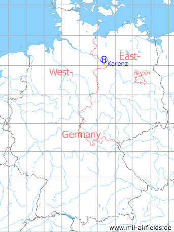
Location of airfield
Southeast of Karenz.
Usage during the Cold War
Helipad 3372 for Radar Company 434 (FuTK-434) of former East German Air Force (NVA LSK/LV).
Use today
Closed.
Runways, taxiways, aprons
Dimensions: 50 m x 60 m,
main takeoff and landing direction: 270°,
surface: concrete,
capacity: 1 helicopter.
main takeoff and landing direction: 270°,
surface: concrete,
capacity: 1 helicopter.
Telephone
Stabsnetz S1 83532-11
Airspace and procedures
Usable at day during good weather conditions.
Alert time: 60 minutes.
Alert time: 60 minutes.
Obstacles
Antenna P-15: direction 260°, distance 100 m, height 25 m
Airfields in the vicinity
- 053°/17km Ludwigslust: Airfield
- 277°/28km Haar: Agricultural Airfield
- 356°/29km Alt Zachun: Agricultural Airfield
- 075°/33km Ziegendorf: Helipad 3346 (HSLP / HLP 3346)
- 307°/34km Banzin: Helipad 3371 (HSLP / HLP 3371)
- 006°/35km Sülte: Airfield (Boldela, Buchholz)
- 353°/35km Warsow: Agricultural Airfield
 Follow mil-airfields on Facebook