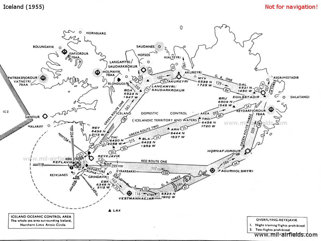
Funkfeuer in Island in den 1950er Jahren
NDB, Range, ILS
Nur zur geschichtlichen Information, nicht zur Navigation oder zum Fliegen verwenden!
Die folgende Liste enthält die Luftfahrt-Funkfeuer, die in Island Mitte der 1950er Jahre aktiv waren. Alle Informationen sind veraltet und dürfen nicht für navigatorische Zwecke verwendet werden.
In dieser Zeit gab es nur ungerichtete Funkfeuer (NDB) und Ranges. Eine Besonderheit war das Racon am Flugplatz Keflavik. In Keflavik gab es auch ein Instrumentenlandesystem (ILS), das jedoch längere Zeit nicht genutzt werden konnte.
Funkfeuer und Luftstraßen
Erläuterungen
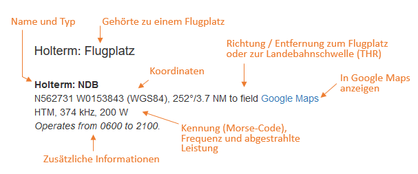
Abkürzungen
| approx. | approximately | ungefähr |
| civ | civil | ziviler Betreiber |
| GP | Glide path | Gleitwegsender |
| ILS | Instrument Landing System | Instrumentenlandesystem |
| IM | Inner Marker | Platzeinflugzeichen. (Markierungsfunkfeuer direkt vor der Landebahn) |
| kHz | Kilohertz | (Einheit für die Frequenz) |
| L | Locator | Ungerichtetes Funkfeuer für den Anflug |
| LLZ | Localizer | Landekurssender |
| LMM | Locator Middle Marker | Kombination aus Locator und Middle Marker |
| LOM | Locator Outer Marker | Kombination aus Locator und Outer Marker |
| m | Meter | (Einheit für die Länge) |
| MHz | Megahertz | (Einheit für die Frequenz) |
| mil | military | militärischer Betreiber |
| MM | Middle Marker | Haupteinflugzeichen (Markierungsfunkfeuer) |
| NDB | Non-directional beacon | Ungerichtetes Funkfeuer auf Lang- oder Mittelwelle |
| NM | Nautical Miles | Seemeilen |
| OM | Outer Marker | Voreinflugzeichen (Markierungsfunkfeuer) |
| PRMG | ПРМГ Посадочная радиомаячная группа | Sowjetisch / russisches militärisches Instrumentenlandesystem |
| RSBN | РСБН Rадиотехническая система ближней навигации | Sowjetisch / russisches militärisches Funknavigationssystem |
| SBA | Standard Beam Approach | Anflughilfe, Lorenz-System, Vorgänger des ILS |
| THR | Threshold | Landebahnschwelle (meist mit Nummer der Landebahn) |
| transf. | transformiert | Koordinaten wurden aus einem anderen Referenzsystem umgerechnet, daher sind Abweichungen möglich. |
| VAR | Visual-Aural Rnange | Range im UKW-Bereich mit optischen und akustischen Signalen |
| VOR | VHF Omnidirectional Radio Range | UKW-Drehfunkfeuer |
| W | Watt | (Einheit für die Leistung) |
| WGS84 | World Geodetic System 1984 | (Geodätisches Referenzsystem, GPS-Koordinaten) |
Verzeichnis
Nur zur geschichtlichen Information, nicht zur Navigation oder zum Fliegen verwenden!
Akureyri: Flugplatz (Akureyrarflugvöllur)
Akureyri: NDB (civ)
N6542 W01806 (approx.), 188°/2.2 NM to field Google Maps
AR, 294.2 kHz, 100 W
N6542 W01806 (approx.), 188°/2.2 NM to field Google Maps
AR, 294.2 kHz, 100 W
Primary aid for Akureyri and Melgerði; weather reports at 45 after the hour. On airway Green Route One.
Asgrimsstadir: NDB
N6534 W01417 (approx.) Google Maps
AS, 325 kHz, 20 W
N6534 W01417 (approx.) Google Maps
AS, 325 kHz, 20 W
On airway Green Route Three. Secondary aid for Egilsstaðir.
Blönduós: Flugplatz (Blönduósarflugvöllur)
Blönduós: NDB (civ)
N6537 W02023 (approx.), 231°/5.0 NM to field Google Maps
BL, 370 kHz, 40 W
N6537 W02023 (approx.), 231°/5.0 NM to field Google Maps
BL, 370 kHz, 40 W
Blönduós Radio transmitted on the beacon frequency 370 kHz and received on 3023.5 kHz
Dalatangi: NDB (20 W)
N6515 W01335 (approx.) Google Maps
DA, 305.7 kHz, 20 W
N6515 W01335 (approx.) Google Maps
DA, 305.7 kHz, 20 W
Operated at 12 and 42 after the hour for 6 minutes
Egilsstaðir: Flugplatz (Egilsstaðaflugvöllur)
Egilsstaðir: NDB (civ)
N6519 W01426 (approx.), 177°/2.0 NM to field Google Maps
EG, 365 kHz, 100 W
N6519 W01426 (approx.), 177°/2.0 NM to field Google Maps
EG, 365 kHz, 100 W
Primary and final aid. At the intersection of airway Green Route One, Green Route Two and Green Route Three.
Nur zur geschichtlichen Information, nicht zur Navigation oder zum Fliegen verwenden!
Fagurhólsmýri: Flugplatz
Fagurhólsmýri: NDB (40 W)
N6353 W01639 (approx.) Google Maps
FM, 400 kHz
N6353 W01639 (approx.) Google Maps
FM, 400 kHz
At the intersection of airway Green Route Three and Red Route One.
Grindavík: Marker
N6350 W02227 (approx.) Google Maps
Dashes, 75 MHz
N6350 W02227 (approx.) Google Maps
Dashes, 75 MHz
The marker was located on the radial 349° to the Keflavik Range.
Hofsós: NDB
N6554 W01925 (approx.) Google Maps
HF, 360 kHz, 20 W
N6554 W01925 (approx.) Google Maps
HF, 360 kHz, 20 W
Missed approach aid for Sauðárkrókur (239°/11 NM)
Hólmavík: Wasserflugplatz
Hornafjörður: Flugplatz
Hornafjörður: NDB
N6415 W01512 (approx.), 250°/0.6 NM to field Google Maps
HN, 287,3 kHz, 100 W
N6415 W01512 (approx.), 250°/0.6 NM to field Google Maps
HN, 287,3 kHz, 100 W
On airway Green Route Three.
Nur zur geschichtlichen Information, nicht zur Navigation oder zum Fliegen verwenden!
Ísafjörður: Wasserflugplatz
Keflavík: Flughafen (Keflavíkurflugvöllur, Keflavík Air Base)
Keflavík: NDB
N6351 W02228 (approx.), 002°/8.5 NM to field Google Maps
TFK, 392 kHz, 2000 W
N6351 W02228 (approx.), 002°/8.5 NM to field Google Maps
TFK, 392 kHz, 2000 W
Located about 7 km southeast of the airfield, near Njarðvík, Reykjanesbær (Njarðvíkurbær).
Keflavík: Racon (USAF)
N6359 W02238 (approx.) Google Maps
1-1, 9310 MHz
N6359 W02238 (approx.) Google Maps
1-1, 9310 MHz
Operated continuously except for Saturdays 0900Z-1200Z.
Keflavík: Range
N6359 W02244 (approx.), 119°/2.0 NM to field Google Maps
KF, 310.3 kHz, 150 W
N6359 W02244 (approx.), 119°/2.0 NM to field Google Maps
KF, 310.3 kHz, 150 W
Located about 5 km west of the airfield, near Hvalsnes. The predefined four courses to the beacon were: 109°, 169°, 299° and 349°. Weather reports at 05 and 35 after the hour.
Malarrif: NDB
N6444 W02348 (approx.) Google Maps
MA, 370 kHz, 20 W
N6444 W02348 (approx.) Google Maps
MA, 370 kHz, 20 W
Operated at 0, 15, 30, 45 for 6 minutes.
Patreksfjörður: Wasserflugplatz
Reyðarfjörður: Wasserflugplatz
Reykjanes: NDB
N6349 W02242 (approx.) Google Maps
RN, 289.9 kHz, 20 W
N6349 W02242 (approx.) Google Maps
RN, 289.9 kHz, 20 W
Operated 10 and 40 after the hour.
Nur zur geschichtlichen Information, nicht zur Navigation oder zum Fliegen verwenden!
Reykjavík: Flughafen (Reykjavíkurflugvöllur)
Reykjavík: Locator (civ)
N6408 W02200 (approx.), 149°/0.13 NM to field Google Maps
Q, 303.4 kHz, 20 W
N6408 W02200 (approx.), 149°/0.13 NM to field Google Maps
Q, 303.4 kHz, 20 W
Aid for let-down runway 14.
Reykjavík: Range (civ)
N6409 W02202 (approx.), 149°/2.0 NM to field Google Maps
RK, 355 kHz, 150 W
N6409 W02202 (approx.), 149°/2.0 NM to field Google Maps
RK, 355 kHz, 150 W
Located at Seltjarnarnes, near the Bakkatjörn Lake. The four predefined courses to the beacon were: 058°, 154°, 244° and 334°.
Sandur
Sandur: NDB (civ)
N6454 W02352 (approx.) Google Maps
SD, 400 kHz, 40 W
N6454 W02352 (approx.) Google Maps
SD, 400 kHz, 40 W
Located near Hellissandur (Snæfellsbær). Operated on request.
Sauðárkrókur: Flugplatz (Sauðárkróksflugvöllur, Alexandersflugvöllur)
Sauðárkrókur: NDB
N6534 W01926 (approx.), 004°/12 NM to field Google Maps
LM, 344 kHz, 100 W
N6534 W01926 (approx.), 004°/12 NM to field Google Maps
LM, 344 kHz, 100 W
Primary aid, located near Varmahlíð. On airway Green Route One.
Sauðárkrókur: NDB
N6543 W01936 (approx.), 337°/1.0 NM to field Google Maps
SB, 379 kHz, 40 W
N6543 W01936 (approx.), 337°/1.0 NM to field Google Maps
SB, 379 kHz, 40 W
Final aid, located at Sjávarborg
Vestmannaeyjar: Flugplatz (Vestmannaeyjaflugvöllur)
Vestmannaeyjar: NDB (civ)
N6325 W02017 (approx.) Google Maps
VM, 375 kHz, 200 W
N6325 W02017 (approx.) Google Maps
VM, 375 kHz, 200 W
On airway Green Route Three.
Nur zur geschichtlichen Information, nicht zur Navigation oder zum Fliegen verwenden!
Karten
Es sind nicht alle Bezeichnungen dargestellt