Radio beacons in Iceland in the 1950s
Sögulegar Flugleiðsögubúnaður á Íslandi 1950s - NDB, Range, ILS
For historical information only, do not use for navigation or aviation purposes!
The following list contains the aeronautical radio beacons that were active in Iceland in the mid of the 1950s. All information is outdated and may not be used for navigational purposes.
At this time there were only non-directional beacons (NDB) and Ranges. A special feature was the Racon at Keflavik airfield. In Keflavik there was also an Instrument Landing System (ILS), which could not be used for a longer time.
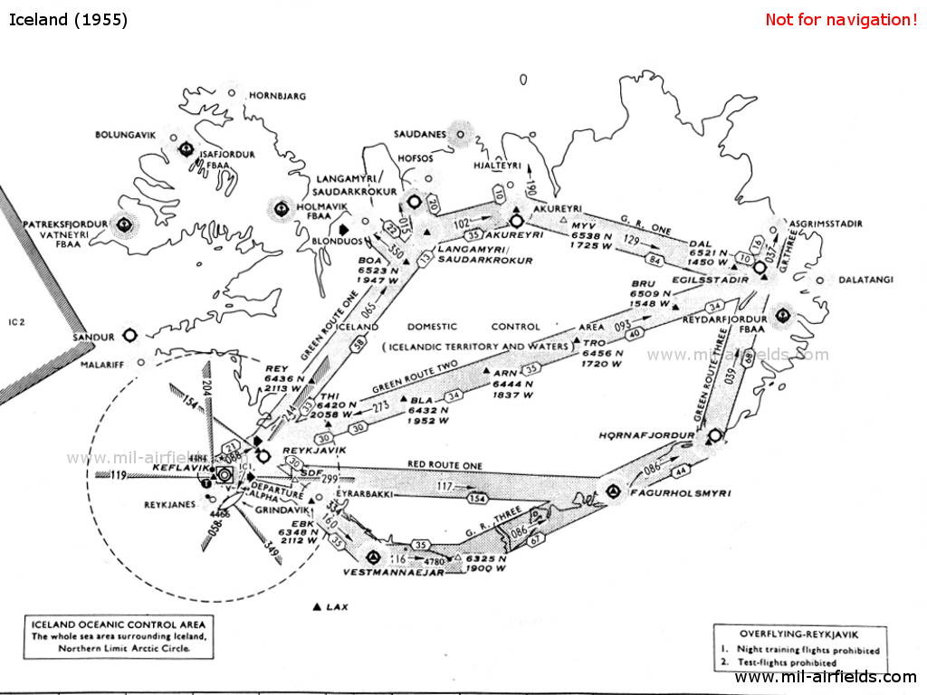
Radio beacons and airways
Explanations
![]()
Abbreviations
| approx. | approximately | |
| civ | civil | civil operator |
| GP | Glide path | Glide path transmitter |
| ILS | Instrument Landing System | (Approach and landing aid) |
| IM | Inner Marker | Marker beacon just in front the runway |
| kHz | Kilohertz | (Unit for frequency) |
| L | Locator | Non-directional beacon for the approach |
| LLZ | Localizer | Localizer transmitter |
| LMM | Locator Middle Marker | Combination of Middle Marker and Locator |
| LOM | Locator Outer Marker | Combination of Outer Marker and Locator |
| m | Meter | (Unit for length) |
| MHz | Megahertz | (Unit for frequency) |
| mil | military | military operator |
| MM | Middle Marker | Marker beacon |
| NDB | Non-directional beacon | Non-directional beacon on long or medium waves |
| NM | Nautical Miles | (Unit for length) |
| OM | Outer Marker | Marker beacon |
| PRMG | ПРМГ Посадочная радиомаячная группа | Soviet / russian military instrument landing system |
| RSBN | РСБН Rадиотехническая система ближней навигации | Soviet / russian military radio navigation system |
| SBA | Standard Beam Approach | Approach system, Lorenz system, predecessor of the ILS |
| THR | Threshold | Runway threshold (most often with number of runway) |
| transf. | transformed | Coordinates were converted from a different reference system, therefore there may be deviations. |
| VAR | Visual-Aural Rnange | |
| VOR | VHF Omnidirectional Radio Range | |
| W | Watt | (Unit for power) |
| WGS84 | World Geodetic System 1984 | (geospatial reference system, GPS coordinates) |
Directory
For historical information only, do not use for navigation or aviation purposes!
Akureyri: Airfield (Akureyrarflugvöllur)
Akureyri: NDB (civ)
N6542 W01806 (approx.), 188°/2.2 NM to field Google Maps
AR, 294.2 kHz, 100 W
N6542 W01806 (approx.), 188°/2.2 NM to field Google Maps
AR, 294.2 kHz, 100 W
Primary aid for Akureyri and Melgerði; weather reports at 45 after the hour. On airway Green Route One.
Asgrimsstadir: NDB
N6534 W01417 (approx.) Google Maps
AS, 325 kHz, 20 W
N6534 W01417 (approx.) Google Maps
AS, 325 kHz, 20 W
On airway Green Route Three. Secondary aid for Egilsstaðir.
Blönduós: Airfield (Blönduósarflugvöllur)
Blönduós: NDB (civ)
N6537 W02023 (approx.), 231°/5.0 NM to field Google Maps
BL, 370 kHz, 40 W
N6537 W02023 (approx.), 231°/5.0 NM to field Google Maps
BL, 370 kHz, 40 W
Blönduós Radio transmitted on the beacon frequency 370 kHz and received on 3023.5 kHz
Dalatangi: NDB (20 W)
N6515 W01335 (approx.) Google Maps
DA, 305.7 kHz, 20 W
N6515 W01335 (approx.) Google Maps
DA, 305.7 kHz, 20 W
Operated at 12 and 42 after the hour for 6 minutes
Egilsstaðir: Airfield (Egilsstaðaflugvöllur)
Egilsstaðir: NDB (civ)
N6519 W01426 (approx.), 177°/2.0 NM to field Google Maps
EG, 365 kHz, 100 W
N6519 W01426 (approx.), 177°/2.0 NM to field Google Maps
EG, 365 kHz, 100 W
Primary and final aid. At the intersection of airway Green Route One, Green Route Two and Green Route Three.
For historical information only, do not use for navigation or aviation purposes!
Fagurhólsmýri: Airfield
Fagurhólsmýri: NDB (40 W)
N6353 W01639 (approx.) Google Maps
FM, 400 kHz
N6353 W01639 (approx.) Google Maps
FM, 400 kHz
At the intersection of airway Green Route Three and Red Route One.
Grindavík: Marker
N6350 W02227 (approx.) Google Maps
Dashes, 75 MHz
N6350 W02227 (approx.) Google Maps
Dashes, 75 MHz
The marker was located on the radial 349° to the Keflavik Range.
Hofsós: NDB
N6554 W01925 (approx.) Google Maps
HF, 360 kHz, 20 W
N6554 W01925 (approx.) Google Maps
HF, 360 kHz, 20 W
Missed approach aid for Sauðárkrókur (239°/11 NM)
Hólmavík: Seaplane station
Hornafjörður: Airfield
Hornafjörður: NDB
N6415 W01512 (approx.), 250°/0.6 NM to field Google Maps
HN, 287,3 kHz, 100 W
N6415 W01512 (approx.), 250°/0.6 NM to field Google Maps
HN, 287,3 kHz, 100 W
On airway Green Route Three.
For historical information only, do not use for navigation or aviation purposes!
Ísafjörður: Seaplane station
Keflavík: Airport (Keflavíkurflugvöllur, Keflavík Air Base)
Keflavík: NDB
N6351 W02228 (approx.), 002°/8.5 NM to field Google Maps
TFK, 392 kHz, 2000 W
N6351 W02228 (approx.), 002°/8.5 NM to field Google Maps
TFK, 392 kHz, 2000 W
Located about 7 km southeast of the airfield, near Njarðvík, Reykjanesbær (Njarðvíkurbær).
Keflavík: Racon (USAF)
N6359 W02238 (approx.) Google Maps
1-1, 9310 MHz
N6359 W02238 (approx.) Google Maps
1-1, 9310 MHz
Operated continuously except for Saturdays 0900Z-1200Z.
Keflavík: Range
N6359 W02244 (approx.), 119°/2.0 NM to field Google Maps
KF, 310.3 kHz, 150 W
N6359 W02244 (approx.), 119°/2.0 NM to field Google Maps
KF, 310.3 kHz, 150 W
Located about 5 km west of the airfield, near Hvalsnes. The predefined four courses to the beacon were: 109°, 169°, 299° and 349°. Weather reports at 05 and 35 after the hour.
Malarrif: NDB
N6444 W02348 (approx.) Google Maps
MA, 370 kHz, 20 W
N6444 W02348 (approx.) Google Maps
MA, 370 kHz, 20 W
Operated at 0, 15, 30, 45 for 6 minutes.
Patreksfjörður: Seaplane Station
Reyðarfjörður: Seaplane Station
Reykjanes: NDB
N6349 W02242 (approx.) Google Maps
RN, 289.9 kHz, 20 W
N6349 W02242 (approx.) Google Maps
RN, 289.9 kHz, 20 W
Operated 10 and 40 after the hour.
For historical information only, do not use for navigation or aviation purposes!
Reykjavík: Airport (Reykjavíkurflugvöllur)
Reykjavík: Locator (civ)
N6408 W02200 (approx.), 149°/0.13 NM to field Google Maps
Q, 303.4 kHz, 20 W
N6408 W02200 (approx.), 149°/0.13 NM to field Google Maps
Q, 303.4 kHz, 20 W
Aid for let-down runway 14.
Reykjavík: Range (civ)
N6409 W02202 (approx.), 149°/2.0 NM to field Google Maps
RK, 355 kHz, 150 W
N6409 W02202 (approx.), 149°/2.0 NM to field Google Maps
RK, 355 kHz, 150 W
Located at Seltjarnarnes, near the Bakkatjörn Lake. The four predefined courses to the beacon were: 058°, 154°, 244° and 334°.
Sandur
Sandur: NDB (civ)
N6454 W02352 (approx.) Google Maps
SD, 400 kHz, 40 W
N6454 W02352 (approx.) Google Maps
SD, 400 kHz, 40 W
Located near Hellissandur (Snæfellsbær). Operated on request.
Sauðárkrókur: Airfield (Sauðárkróksflugvöllur, Alexandersflugvöllur)
Sauðárkrókur: NDB
N6534 W01926 (approx.), 004°/12 NM to field Google Maps
LM, 344 kHz, 100 W
N6534 W01926 (approx.), 004°/12 NM to field Google Maps
LM, 344 kHz, 100 W
Primary aid, located near Varmahlíð. On airway Green Route One.
Sauðárkrókur: NDB
N6543 W01936 (approx.), 337°/1.0 NM to field Google Maps
SB, 379 kHz, 40 W
N6543 W01936 (approx.), 337°/1.0 NM to field Google Maps
SB, 379 kHz, 40 W
Final aid, located at Sjávarborg
Vestmannaeyjar: Airfield (Vestmannaeyjaflugvöllur)
Vestmannaeyjar: NDB (civ)
N6325 W02017 (approx.) Google Maps
VM, 375 kHz, 200 W
N6325 W02017 (approx.) Google Maps
VM, 375 kHz, 200 W
On airway Green Route Three.
For historical information only, do not use for navigation or aviation purposes!
Maps
Not all labels are shown