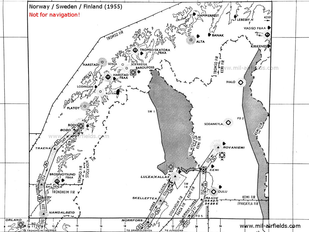
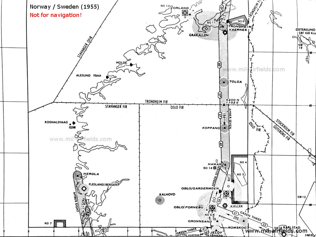
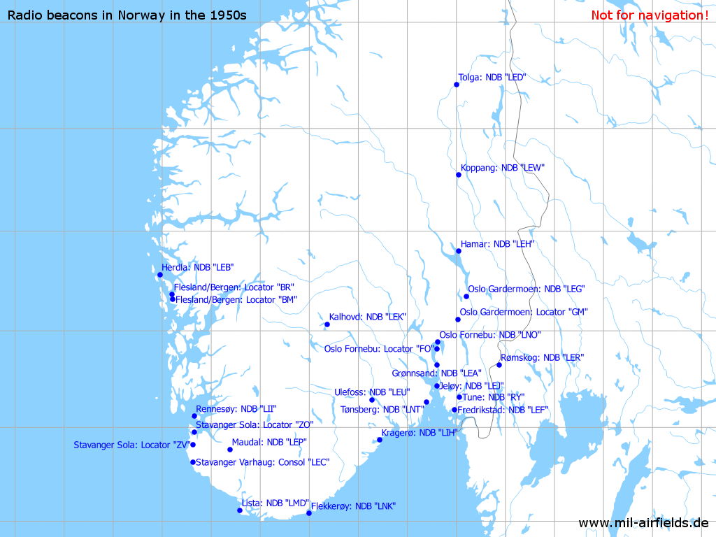
Die folgende Liste enthält die Luftfahrt-Funkfeuer, die in Norwegen Mitte der 1950er Jahren aktiv waren. Alle Informationen sind veraltet und dürfen nicht für navigatorische Zwecke verwendet werden.
In dieser Zeit gab es vorwiegend ungerichtete Funkfeuer (NDB). Die Kennung der meisten Streckenfunkfeuer bestand aus drei Buchstaben und begann mit einem L, gefolgt von einem E, I, M, oder N. Der dritte Buchstabe richtet sich manchmal nach dem Ort. Eine Systematik ist schwer erkennbar. Funkfeuer für den Anflug von Flugplätzen hatten zwei Buchstaben, die sich meist am Ort orientierten.
Eine Besonderheit stellte das Funkfeuer Stavanger Varhaug dar, denn es war vom Typ Consol, dem Nachfolger des deutschen Funkfeuers "Sonne".
Einzelne Flugplätze waren mit dem Instrumentenlandesystem (ILS) ausgestattet. Es gab einige Wasserflugplätze, die ein NDB hatten.
Funkfeuer und Luftstraßen
1
2
3
Erläuterungen
Abkürzungen
| approx. | approximately | ungefähr |
| civ | civil | ziviler Betreiber |
| GP | Glide path | Gleitwegsender |
| ILS | Instrument Landing System | Instrumentenlandesystem |
| IM | Inner Marker | Platzeinflugzeichen.
(Markierungsfunkfeuer direkt vor der Landebahn) |
| kHz | Kilohertz | (Einheit für die Frequenz) |
| L | Locator | Ungerichtetes Funkfeuer für den Anflug |
| LLZ | Localizer | Landekurssender |
| LMM | Locator Middle Marker | Kombination aus Locator und Middle Marker |
| LOM | Locator Outer Marker | Kombination aus Locator und Outer Marker |
| m | Meter | (Einheit für die Länge) |
| MHz | Megahertz | (Einheit für die Frequenz) |
| mil | military | militärischer Betreiber |
| MM | Middle Marker | Haupteinflugzeichen (Markierungsfunkfeuer) |
| NDB | Non-directional beacon | Ungerichtetes Funkfeuer auf Lang- oder Mittelwelle |
| NM | Nautical Miles | Seemeilen |
| OM | Outer Marker | Voreinflugzeichen (Markierungsfunkfeuer) |
| PRMG | ПРМГ Посадочная радиомаячная группа | Sowjetisch / russisches militärisches Instrumentenlandesystem |
| RSBN | РСБН Rадиотехническая система ближней навигации | Sowjetisch / russisches militärisches Funknavigationssystem |
| SBA | Standard Beam Approach | Anflughilfe, Lorenz-System, Vorgänger des ILS |
| THR | Threshold | Landebahnschwelle (meist mit Nummer der Landebahn) |
| transf. | transformiert | Koordinaten wurden aus einem anderen Referenzsystem umgerechnet, daher sind Abweichungen möglich. |
| VAR | Visual-Aural Rnange | Range im UKW-Bereich mit optischen und akustischen Signalen |
| VOR | VHF Omnidirectional Radio Range | UKW-Drehfunkfeuer |
| W | Watt | (Einheit für die Leistung) |
| WGS84 | World Geodetic System 1984 | (Geodätisches Referenzsystem, GPS-Koordinaten) |
Verzeichnis
Nur zur geschichtlichen Information, nicht zur Navigation oder zum Fliegen verwenden!
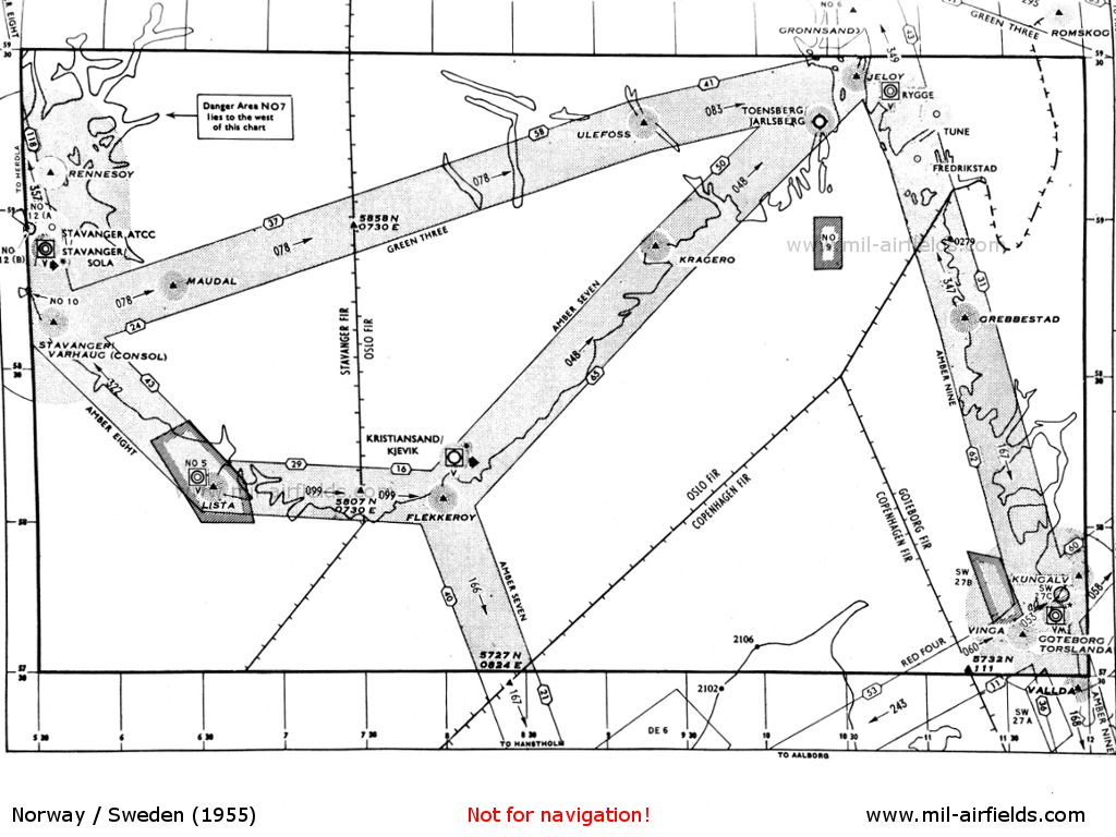
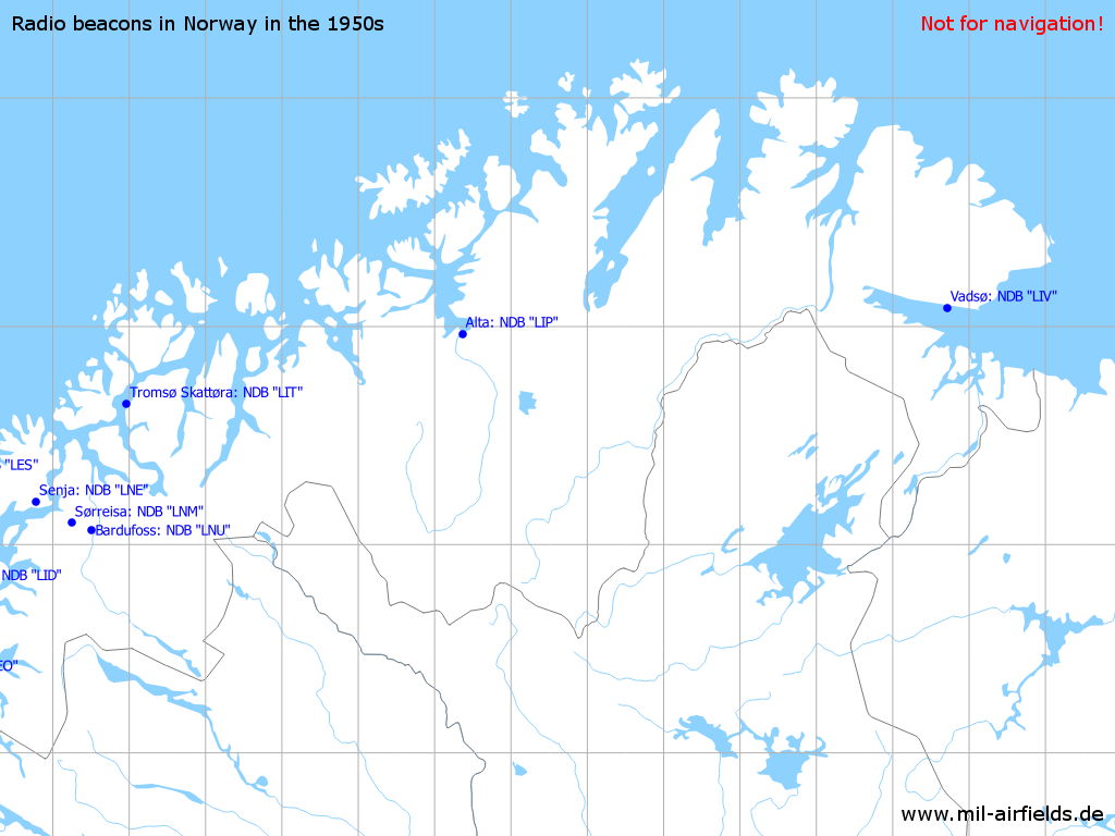
Alta: NDBN6958 E02322 (approx.)
Google MapsLIP, 365 kHz
Operated weekdays from 0645 until 1445.
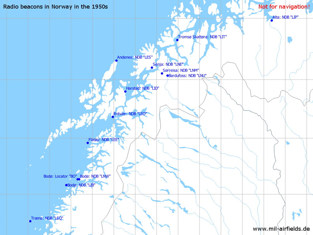
Harstad: Wasserflugplatz
Andenes: NDBN6919 E01607 (approx.), 167°/32.2 NM to field
Google MapsLES, 356 kHz, 100 W
Bardufoss: Flugplatz (Bardufoss lufthavn, Bardufoss flystasjon)
Bardufoss: NDBN6904 E01830 (approx.)
Google MapsLNU, 378 kHz
Operated on request between 0600 and 1900.
Bodø (Bodø lufthavn, Bodø hovedflystasjon, Luftforsvarsbase Bodø, Bodo)
Bodø: LocatorN6716 E01419 (approx.)
Google MapsBO, 338 kHz
Bodø: NDBN6710 E01347 (approx.), 068°/14.0 NM to field
Google MapsLIB, 374 kHz, 100 W
Bodø: NDBN6716 E01423 (approx.)
Google MapsLNW, 352 kHz, 2000 W
Runway 08:
Bodø: ILS 08
BO, 110.3 MHz
Bodø: MM 08
080°/0.55 NM to THR 08
Dots Dashes, 75 MHz
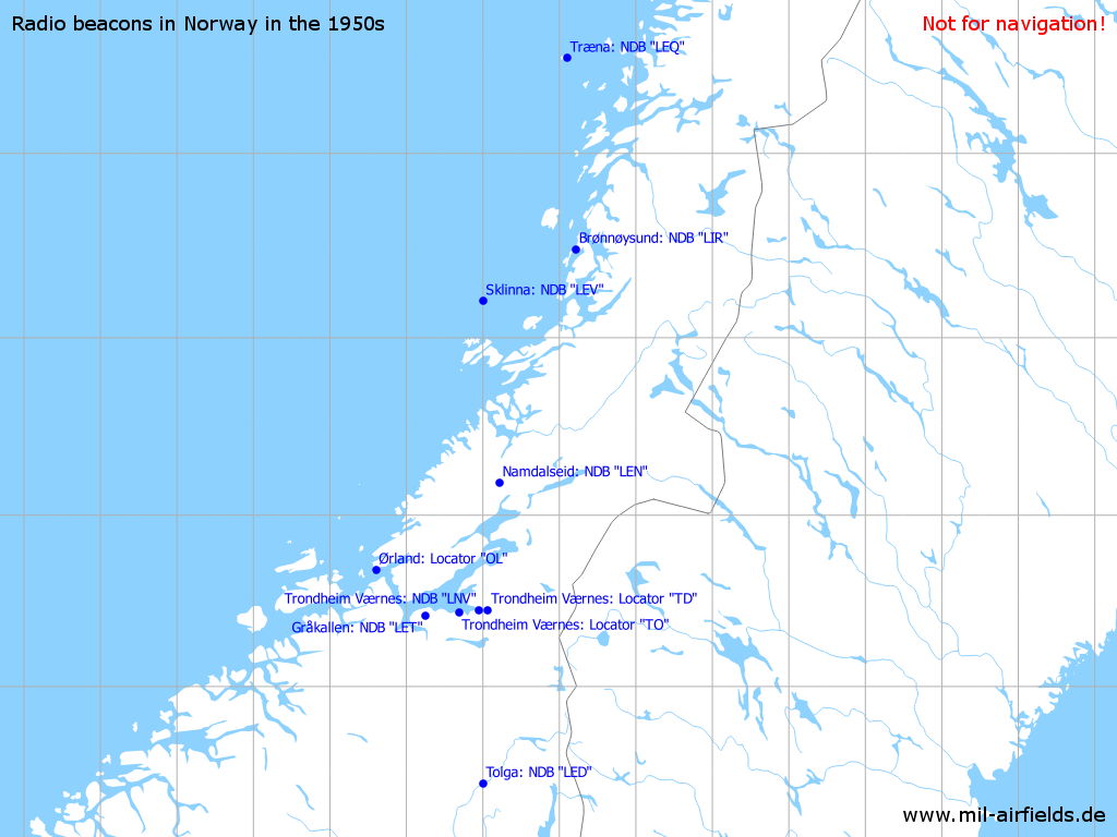
Brønnøysund: Wasserflugplatz
Brønnøysund: NDBN6529 E01213 (approx.)
Google MapsLIR, 345 kHz
Operated on request / at aerodrome times from 0445 to 1800.
Flatøy: NDBN6755 E01447 (approx.)
Google MapsLEE, 260 kHz
Nur zur geschichtlichen Information, nicht zur Navigation oder zum Fliegen verwenden!
Flekkerøy: NDBN5805 E00800 (approx.)
Google MapsLNK, 372 kHz, 100 W
At the intersection of airway Amber Seven (A7) and Amber Eight (A8). Also used for approaches to Kristiansand/Kjevik airfield.
Bergen: Flughafen (Bergen Lufthavn, Flesland)
Flesland/Bergen: LocatorN6019 E00513 (approx.)
Google MapsBM, 374 kHz
Operated at aerodrome times from 0430 to 2300.
Flesland/Bergen: LocatorN6022 E00512 (approx.)
Google MapsBR, 360 kHz
Operated at aerodrome times from 0430 to 2300.
Runway 18:
Flesland/Bergen: ILS 18BR, 109.9 MHz
To runway 18 (178°)
Flesland/Bergen: OM 18
Dashes, 75 MHz
Flesland/Bergen: MM 18
Dots Dashes, 75 MHz
Fredrikstad: NDBN5911 E01058 (approx.)
Google MapsLEF, 328 kHz
On airway Amber Nine (A9).
Gråkallen: NDBN6325 E01015 (approx.)
Google MapsLET, 358 kHz
Grønnsand: NDBN5939 E01036 (approx.)
Google MapsLEA, 358 kHz
Hamar: NDBN6048 E01103 (approx.)
Google MapsLEH, 269 kHz
On airway Amber Seven (A7).
Harstad: Wasserflugplatz
Harstad: NDBN6848 E01632 (approx.), 088°/0.6 NM to field
Google MapsLID, 371 kHz, 100 W
Operated at aerodrome times from 0445 to 1900.
Nur zur geschichtlichen Information, nicht zur Navigation oder zum Fliegen verwenden!
Herdla: NDBN6034 E00457 (approx.)
Google MapsLEB, 391 kHz
At the northern end of airway Amber Eight (A8).
Jeløy: NDBN5926 E01036 (approx.)
Google MapsLEJ, 381 kHz, 100 W
At the intersection of airways Amber Seven (A7), Amber Nine (A9), Green Three (G9)
Kalhovd: NDBN6004 E00822 (approx.)
Google MapsLEK, 346 kHz
Koppang: NDBN6133 E01103 (approx.)
Google MapsLEW, 370 kHz
On airway Amber Seven (A7).
Kragerø: NDBN5852 E00926 (approx.)
Google MapsLIH, 265 kHz, 100 W
Kristiansand: Flughafen Kjevik (Kristiansand lufthavn, Kjevik)
Kristiansand: Locator040°/0.7 NM to field
CN, 394 kHz
Operated from 0600 to 2100.
Lista: Flugplatz (Vanse, Farsund)
Lista: NDBN5807 E00635 (approx.)
Google MapsLMD, 385 kHz
On airway Amber Eight (A8).
Nur zur geschichtlichen Information, nicht zur Navigation oder zum Fliegen verwenden!
Maudal: NDBN5846 E00623 (approx.)
Google MapsLEP, 277 kHz, 100 W
Namdalseid: NDBN6411 E01113 (approx.)
Google MapsLEN, 283 kHz
On airway Amber Seven (A7).
Ørland: Flugplatz (Ørland lufthavn, Brekstad, Ørland hovedflystasjon)
Ørland (Orlandet): LocatorN6341 E00936 (approx.)
Google MapsOL, 349 kHz, 100 W
At field.
Oslo: Flughafen Fornebu (Oslo lufthavn, Fornebu)
Oslo Fornebu: NDBN5953 E01037 (approx.)
Google MapsLNO, 340 kHz, 1500 W
Was located on Snarøya peninsula, in the area of Snarøyveien/Bruksveien. Previous ident and frequency were FB, 387 kHz,
Runway 01:
Oslo Fornebu: ILS 01FB, 110.3 MHz
Backbeam not to be used.
Oslo Fornebu: LOM 01N5949 E01036 (approx.), 011°/4.5 NM to THR 01
Google MapsLocator: FO, 279 kHz
Outer Marker: Dashes, 75 MHz
Was located on Fyrsteilene island. Operated from 0630 to 2330.
Oslo Fornebu: MM 01
011°/0.8 NM to THR 11
Dots Dashes, 75 MHz
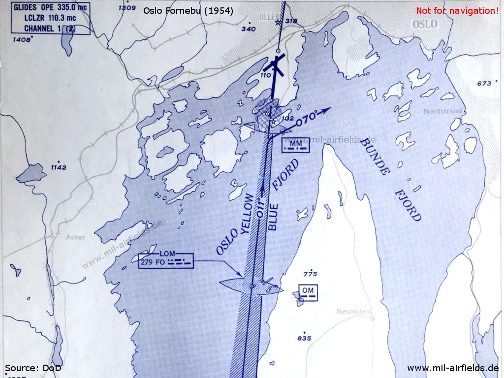
ILS-Anflug auf die Landebahn 01 in Oslo Fornebu im Jahr 1954 - Wegen der schwierigen Hindernissituation nördlich des Flughafens muss bei einem Fehlanflug bereits vor der Landebahn nach rechts auf Kurs 070° abgedreht werden.
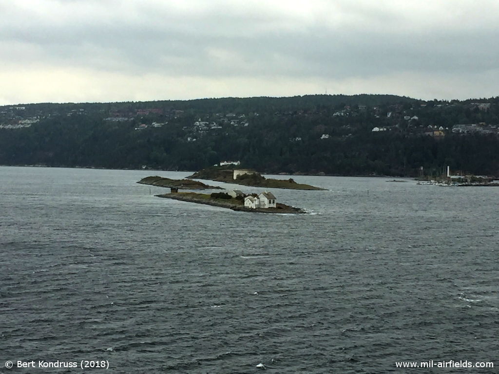
Insel Fyrsteilene mit der Steilene fyrstasjon im Oslofjord im Jahr 2018 - Fyrsteilene ist die kleine Insel im Vordergrund, hier befand sich das Funkfeuer "FO" und der Outer Marker für Oslo Fornebu
Oslo: Flughafen Gardermoen (Oslo lufthavn, Gardermoen flystasjon)
Oslo Gardermoen: LocatorN6007 E01102 (approx.), 021°/5.05 NM to field
Google MapsGM, 259 kHz
Was located near Holter. Operated from 0600 to 2200.
Oslo Gardermoen: Tomte MarkerN6022 E01114 (approx.)
Google MapsDashes, 75 MHz
Was located south of Minnesund, on radial 208° to Gardermoen Range.
Oslo Gardermoen: NDBGR, 387 kHz
Operated from 0600 to 2000.
Oslo Gardermoen: NDBN6021 E01112 (approx.), 203°/9.72 to field
Google MapsLEG, 375 kHz
Oslo Gardermoen: RangeN6016 E01109 (approx.)
Google MapsGD, 352 kHz
Was located near Råholt. The four predefined courses to the Range were: 026°, 132°, 208° and 307°.
Runway 20:
Oslo Gardermoen: ILS 20GN, 109.9 MHz
To runway 20.
Oslo Gardermoen: OM 20
200°/4.3 NM to THR 20
Dashes, 75 MHz
Oslo Gardermoen: MM 20
200°/0.57 NM to THR 20
Dots Dashes, 75 MHz
Oslo Gardermoen: IM 20
200°/0.04 NM to THR 20
Dots, 75 MHz
Rennesøy: NDBN5907 E00539 (approx.)
Google MapsLII, 398 kHz
Rømskog: NDBN5939 E01152 (approx.)
Google MapsLER, 363.5 kHz
On airway Green Three (G3) at the boundary between Oslo Flight Information Region (FIR) and Göteborg FIR.
Nur zur geschichtlichen Information, nicht zur Navigation oder zum Fliegen verwenden!
Rotvær: NDBN6822 E01557 (approx.)
Google MapsLEO, 365 kHz
(Fugløya island, Lødingen)
Senja: NDBN6912 E01747 (approx.)
Google MapsLNE, 328 kHz
(Sážža)
Sklinna: NDBN6512 E01100 (approx.)
Google MapsLEV, 321 kHz
(Leka). On airway Amber Seven (A7) at the boundary between Trondheim FIR and Tromsø FIR.
Sørreisa: NDBN6906 E01815 (approx.)
Google MapsLNM, 350 kHz
(Ráisavuona)
Stavanger: Flughafen Sola (Stavanger lufthavn, Sola; Sola flystasjon)
Runway 01:
Stavanger Sola: LocatorN5849 E00538 (approx.), 305°/4.0 NM to field
Google MapsZV, 378 kHz, 10 W
Runway 19:
Stavanger Sola: ILS 19ZV, 110.3 MHz
To runway 19 (187°).
Stavanger Sola: LOM 19N5857 E00539 (approx.), 186°/3.85 NM to THR 19
Google MapsLocator: ZO, 352 kHz
Outer Marker: Dashes, 75 MHz
Operated from 0530 to 2130.
Stavanger Sola: MM 19186°/0.66 NM to THR 19
Dots Dashes, 75 MHz
Not sure if this information is correct. The runway threshold at this time was very similar to today. So with a distance of 0.66 NM to the north, it must have been located in the waters of the Hafrsfjorden.
Stavanger Sola: IM 19
186°/0.05 NM to THR 19
Dots, 75 MHz
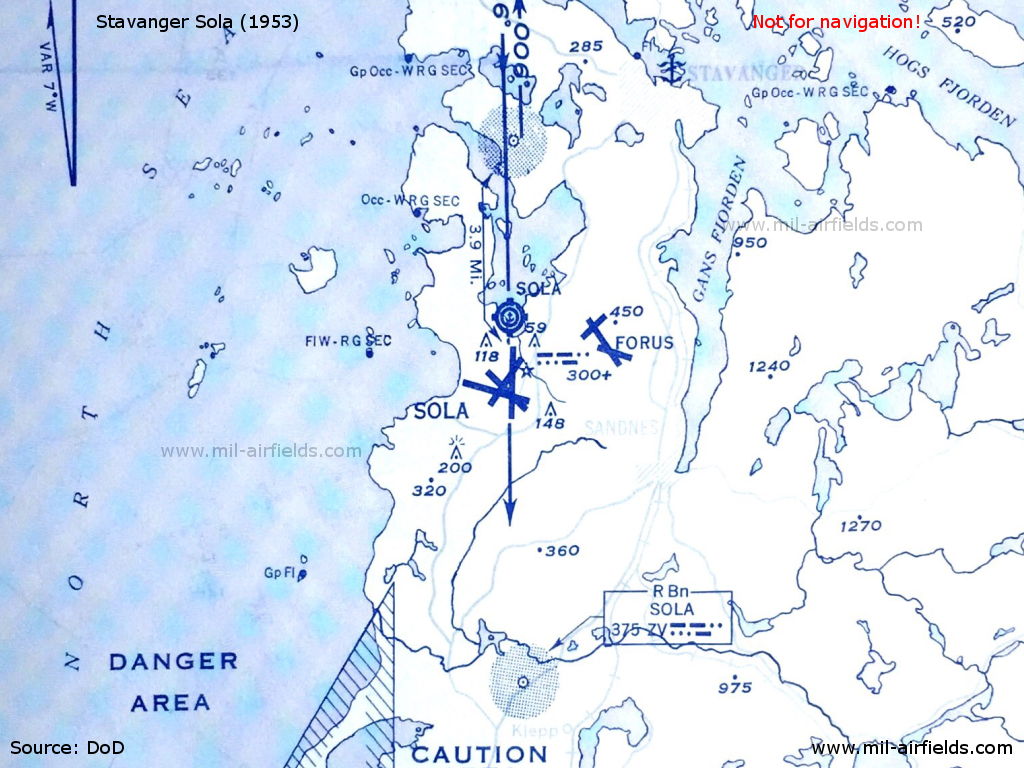
Karte von Stavanger Sola aus dem Jahr 1953
Stavanger Varhaug: ConsolN5838 E00538 (approx.), 006°/15.1 NM to Sola airfield
Google MapsLEC, 319 kHz, 1500 W
(Hå). At the intersection of airway Amber Eight (A8) with Green Three (G3). Consol-cycle of 120 seconds.
Tolga: NDBN6225 E01100 (approx.)
Google MapsLED, 394 kHz
On airway Amber Seven (A7).
Nur zur geschichtlichen Information, nicht zur Navigation oder zum Fliegen verwenden!
Tønsberg: Flugplatz Jarlsberg
Tønsberg: NDBN5916 E01023 (approx.), 001°/1.2 NM to field
Google MapsLNT, 283 kHz
Træna: NDBN6630 E01206 (approx.)
Google MapsLEQ, 360 kHz
On airway Amber Seven (A7).
Tromsø: Wasserflugplatz Skattøra
Tromsø Skattøra: NDBN6939 E01858 (approx.), 059°/1.9 NM to field
Google MapsLIT, 321 kHz, 100 W
Operated at aerodrome times from 0545 to 2100 and on request.
Trondheim: Flughafen (Trondheim lufthavn, Værnes)
Trondheim Værnes: LocatorN6327 E01104 (approx.), 271°/3.3 NM to field
Google MapsTD, 317 kHz
Located about 7 km east of the field. Previous frequency 352 kHz (1954).
Trondheim Værnes: LocatorN6326 E01041 (approx.), 084°/6.6 NM to field
Google MapsTO, 326 kHz
Located about 12 km west-southwest of the airfield, near Malvik. Previous frequency 358 kHz (1954).
Trondheim Værnes: NDBN6327 E01057 (approx.), 283°/0.6 NM to field
Google MapsLNV, 374 kHz, 100 W
Located in the southeastern part of the airfield, close to the Stjørdalselva river.
Tune: NDBN5919 E01104 (approx.)
Google MapsRY, 315.5 kHz
Ulefoss: NDBN5917 E00917 (approx.)
Google MapsLEU, 368 kHz, 100 W
On airway Green Three (G3). Maximum range 18 NM.
Vadsø: Wasserflugplatz (Vadsø sjøflyplass)
Vadsø: NDBN7005 E02943 (approx.)
Google MapsLIV, 370 kHz, 100 W
Operated from 0645 to 1400
Nur zur geschichtlichen Information, nicht zur Navigation oder zum Fliegen verwenden!
Karten
1
2
3
4
Es sind nicht alle Bezeichnungen dargestellt