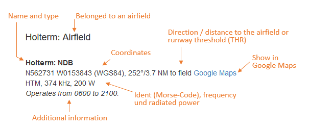
The following list contains the aeronautical radio beacons that were active in Norway in 1960. All information is outdated and may not be used for navigational purposes.
At this time there were mainly non-directional beacons (NDB). The identification of most en-route beacons consisted of three letters and began with an L, followed by an E, I, M, or N. The third letter sometimes corresponded to the location. A systematic approach is difficult to recognize. Radio beacons for the approach to airfields had two letters, mostly according to the name of the airfield.
The radio beacon Stavanger Varhaug was still special, because it was of the type Consol, the successor of the German radio beacon "Sonne".
There were some VORs (VHF omnidirectional radio range). There weren't any TACANs at the military airfields yet.
Several airfields were equipped with the Instrument Landing System (ILS).
Maps
Explanations
Abbreviations
| approx. | approximately | |
| civ | civil | civil operator |
| GP | Glide path | Glide path transmitter |
| ILS | Instrument Landing System | (Approach and landing aid) |
| IM | Inner Marker | Marker beacon just in front the runway |
| kHz | Kilohertz | (Unit for frequency) |
| L | Locator | Non-directional beacon for the approach |
| LLZ | Localizer | Localizer transmitter |
| LMM | Locator Middle Marker | Combination of Middle Marker and Locator |
| LOM | Locator Outer Marker | Combination of Outer Marker and Locator |
| m | Meter | (Unit for length) |
| MHz | Megahertz | (Unit for frequency) |
| mil | military | military operator |
| MM | Middle Marker | Marker beacon |
| NDB | Non-directional beacon | Non-directional beacon on long or medium waves |
| NM | Nautical Miles | (Unit for length) |
| OM | Outer Marker | Marker beacon |
| PRMG | ПРМГ Посадочная радиомаячная группа | Soviet / russian military instrument landing system |
| RSBN | РСБН Rадиотехническая система ближней навигации | Soviet / russian military radio navigation system |
| SBA | Standard Beam Approach | Approach system, Lorenz system, predecessor of the ILS |
| THR | Threshold | Runway threshold (most often with number of runway) |
| transf. | transformed | Coordinates were converted from a different reference system, therefore there may be deviations. |
| VAR | Visual-Aural Rnange | |
| VOR | VHF Omnidirectional Radio Range | |
| W | Watt | (Unit for power) |
| WGS84 | World Geodetic System 1984 | (geospatial reference system, GPS coordinates) |
Directory
For historical information only, do not use for navigation or aviation purposes!
Ålesund: Airfield (Ålesund lufthavn, Vigra)
Ålesund: NDBN6234 E00608 (approx.), field
Google MapsLNI, 355 kHz
Runway 25:
Ålesund: ILS 25AL, 109.5 MHz
To runway 25 (246°). Operated from 0700 to 1000 and from 1200 to 2000.
Ålesund: Lepsoy LOM 25N6236 E00614 (approx.), 246°/3.5 NM to THR 25
Google MapsLocator: AL, 398 kHz
Alta: NDB (civ)
N6958 E02321 (approx.)
Google MapsLIP, 365 kHz
Operated Monday to Saturday from 0700 until 1430.
Åndalsnes: NDBN6234 E00741 (approx.)
Google MapsLIQ, 345 kHz
Andenes: NDB (civ)
N6919 E01607 (approx.), 167°/32.2 NM to field
Google MapsLES, 356 kHz
Bardufoss: Air Base (Bardufoss lufthavn, Bardufoss flystasjon)
Bardufoss: NDB (RNoAF)
N6905 E01822 (approx.), 159°/3.8 NM to field
Google MapsDO, 350 kHz
Bardufoss: NDB (RNoAF)
N6903 E01836 (approx.), 260°/1.1 NM to field
Google MapsDU, 371 kHz
Runway 17:
Bardufoss: ILS 17 (RNoAF)
DU, 110.3 MHz
To runway 17 (116°). Operated from 0530 to 1730, on test.
Bardufoss: Sørreisa LOM 17 (RNoAF)
N6906 E01815 (approx.), 116°/5.8 NM to THR 17
Google MapsLocator: LNM, 338 kHz
Outer Marker: Dashes, 75 MHz
(Ráisavuona)
Bardufoss: MM 17 (RNoAF)
116°/1.8 NM to THR 17
Dots Dashes, 75 MHz
Bodø (Bodø lufthavn, Bodø hovedflystasjon, Luftforsvarsbase Bodø, Bodo)
Bodø: NDB (RNoAF)
N6716 E01423 (approx.), 225°/0.5 NM to field
Google MapsLNW, 352 kHz, 2000 W
Runway 08:
Bodø: ILS 08
BO, 110.3 MHz
Bodø: LMMN6716 E01419 (approx.), 080°/0.6 NM to THR 08
Google MapsLocator: BO, 338 kHz
Middle Marker: Dots Dashes, 75 MHz
For historical information only, do not use for navigation or aviation purposes!
Brønnøysund: NDBN6529 E01213 (approx.)
Google MapsLIR, 345 kHz
On airway Amber 7 (A7).
Fagernes: NDBN6105 E00924 (approx.)
Google MapsLEJ, 332 kHz
Flatøy: NDBN6755 E01447 (approx.)
Google MapsLEE, 260 kHz
On airway Amber 7 (A7).
Fleinvær: NDBN6710 E01346 (approx.), 065°/15.3 NM to Bodø
Google MapsLIX, 374 kHz, 100 W
On airway Amber 7 (A7).
Flekkerøy: NDBN5805 E00800 (approx.), 027°/7.5 NM to Kjevik
Google MapsLNK, 372 kHz, 100 W
At the intersection of airway Amber 7 (A7) and Amber 8 (A8).
Flekkerøy: VORN5804 E00759 (approx.)
Google MapsCC, 112.1 MHz
Bergen: Airport (Bergen Lufthavn, Flesland)
Flesland/Bergen: VORN6018 E00513 (approx.)
Google MapsBB, 114.5 MHz
On test.
Runway 18:
Flesland/Bergen: ILS 18BR, 109.9 MHz
To runway 18 (178°)
Flesland/Bergen: Alvøen LOM 18N6022 E00512 (approx.), 178°/3.8 NM to THR 18
Google MapsLocator: BR, 360 kHz
Flesland/Bergen: LMM 18N6019 E00513 (approx.), 178°/0.5 NM to THR 18
Google MapsLocator: BM, 374 kHz
Runway 36:
Flesland/Bergen: Bratta NDBN6003 E00519 (approx.), 358°/12.6 NM to THR 36
Google MapsLIH, 336 kHz
(Tysnes/Tysnesøy, Hordaland).
Flesland/Bergen: Korsnes
358°/3.6 NM to THR 36
B, 75 MHz
Fredrikstad: NDBN5911 E01058 (approx.)
Google MapsLEF, 328 kHz
On airway Amber Nine (A9).
For historical information only, do not use for navigation or aviation purposes!
Frei: NDBN6302 E00749 (approx.)
Google MapsLIS, 385 kHz
Frei island.
Furnes: NDBN6718 E01509 (approx.), 266°/18.0 NM to Bodø
Google MapsLIC, 326 kHz, 100 W
Gråkallen: NDBN6325 E01015 (approx.), 087°/18.5 NM to Trondheim Værnes
Google MapsLET, 358 kHz
Grønnsand: NDBN5939 E01035 (approx.), 007°/14.5 NM to Oslo Fornebu
Google MapsLEA, 358 kHz
Hamar: NDBN6048 E01103 (approx.)
Google MapsLEH, 269 kHz
On airway Amber Seven (A7).
Harstad: Seaplane Base (Harstad sjøflyplass)
Harstad: NDBN6848 E01632 (approx.)
Google MapsLID, 381 kHz
Herdla: NDBN6034 E00457 (approx.)
Google MapsLEB, 391 kHz
For historical information only, do not use for navigation or aviation purposes!
Kalhovd: NDBN6000 E00823 (approx.)
Google MapsLEK, 347 kHz
On airway Green 3 (G3).
Koppang: NDBN6133 E01103 (approx.)
Google MapsLEW, 371 kHz
Kristiansand: Kjevik Airport (Kristiansand lufthavn, Kjevik)
Runway 04:
Kristiansand: ILS 04CN, 110.3 MHz
To runway 04 (041°).
Kristiansand: Odderøya LOM 04N5808 E00800 (approx.), 041°/4.2 NM to field
Google MapsLocator: CO, 345 kHz
Kristiansand: Hestnes LMM 04N5811 E00803 (approx.), 041°/1.5 NM to THR 04
Google MapsLocator: CU, 394 kHz
Kristiansand: IM 04
041°/0.1 NM to THR 04
Dots, 75 MHz
Lista: Air Base (Vanse, Farsund)
Lista: NDBN5804 E00641 (approx.), 317°/2.4 NM to field
Google MapsLIJ, 385 kHz
Operated from 0500 to 2000.
Maudal: NDBN5846 E00623 (approx.)
Google MapsLEP, 277 kHz
Namdalseid: NDBN6411 E01113 (approx.)
Google MapsLEN, 285 kHz
On airway Amber Seven (A7).
Omastrand: NDBN6013 E00559 (approx.)
Google MapsLIL, 326 kHz
For historical information only, do not use for navigation or aviation purposes!
Oslo: Fornebu Airport (Oslo lufthavn, Fornebu)
Oslo Fornebu: VOR
at field
FF, 112.9 MHz
Runway 01:
Oslo Fornebu: ILS 01FB, 110.3 MHz
To runway 01 (011°). Localizer and glide path unreliable. Back beam prohibited for use.
Oslo Fornebu: LOM 01N5949 E01036 (approx.), 011°/4.3 NM to THR 01
Google MapsLocator: FO, 352 kHz
Outer Marker: Dashes, 75 MHz
Located on Fyrsteilene island.
Oslo Fornebu: LMM 01N5953 E01037 (approx.), 011°/0.4 NM to THR 01
Google MapsLocator: LNO, 340 kHz, 1500 W
Middle Marker: Dots Dashes, 75 MHz
Snarøya peninsula. The locator was slightly displaced to the west of the extended runway centerline.
Oslo: Gardermoen Airport (Oslo lufthavn, Gardermoen flystasjon)
Oslo Gardermoen: EidsvollN6021 E01112 (approx.), 203°/9.72 to field
Google MapsLEG, 375 kHz
Runway 20:
Oslo Gardermoen: ILS 20GM, 109.9 MHz
To runway 20 (200°).
Oslo Gardermoen: OM 20
200°/4.2 NM to THR 20
Dashes, 75 MHz
Oslo Gardermoen: NDB (RNoAF)
202°/2.7 NM to field
GR, 387 kHz
Oslo Gardermoen: MM 20
200°/0.6 NM to THR 20
Dots Dashes, 75 MHz
Rennesøy: NDBN5908 E00539 (approx.), 186°/15.1 NM to Stavanger Sola
Google MapsLII, 398 kHz
On airway Amber 8 (A8).
Rømskog: NDBN5939 E01152 (approx.)
Google MapsLER, 364 kHz
On airway Green 3 (G3) at the boundary between Oslo Flight Information Region (FIR) and Göteborg FIR.
Røros: Airfield
Røros: NDBN6235 E01121 (approx.)
Google MapsRO, 336 kHz
At field.
Rott: NDBN5855 E00531 (approx.), 127°/4.1 NM to Stavanger Sola
Google MapsLIZ, 378 kHz
On Rott island.
Rotvær: NDBN6822 E01557 (approx.)
Google MapsLEO, 365 kHz
(Fugløya island, Lødingen). On airway Amber 7 (A7).
For historical information only, do not use for navigation or aviation purposes!
Senja: NDBN6912 E01747 (approx.), 117°/18.0 NM to Bardufoss
Google MapsLNE, 328 kHz
(Sážža, Solli). Northern end of airway Amber 7 (A7).
Skien: NDBN5914 E00942 (approx.)
Google MapsLEM, 368 kHz
On airway Amber 7 (A7).
Skien: VORN5914 E00942 (approx.)
Google MapsSV, 113.6 MHz
On airway Amber 7 (A7).
Stavanger: Sola Airport (Stavanger lufthavn, Sola; Sola flystasjon)
Runway 19:
Stavanger Sola: ILS 19ZV, 110.3 MHz
To runway 19 (185°). Operated from 0400 to 2130.
Stavanger Sola: LOM 19N5857 E00539 (approx.), 185°/3.8 NM to THR 19
Google MapsLocator: ZO, 352 kHz
Outer Marker: Dashes, 75 MHz
Operated from 0400 to 2130.
Stavanger Sola: MM 19186°/0.7 NM to THR 19
Dots Dashes, 75 MHz
Not sure if this information is correct. The runway threshold at this time was very similar to today. So with a distance of 0.7 NM to the north, it must have been located in the waters of the Hafrsfjorden.
Stavanger Sola: IM 19
186° to THR 19
Dots, 75 MHz
Runway 35:
Stavanger Sola: Marker
THR 35
Z, 75 MHz
Stavanger Varhaug: ConsolN5838 E00538 (approx.), 006°/15.1 NM to Stavanger Sola airfield
Google MapsLEC, 319 kHz, 1500 W
(Hå).
Stavanger Varhaug: VORN5838 E00536 (approx.)
Google MapsZZ, 114.1 MHz
Støtt: NDBN6656 E01327 (approx.), 048°/30.0 NM to Bodø
Google MapsLIA, 317 kHz, 100 W
(Støttvær).
Tarva: NDBN6350 E00926 (approx.), 151°/9.0 NM to Ørland
Google MapsLIO, 349 kHz
Tolga: NDBN6224 E01059 (approx.)
Google MapsLED, 394 kHz
On airway Amber Seven (A7).
For historical information only, do not use for navigation or aviation purposes!
Torp: Airfield (Sandefjord lufthavn)
Torp: NDB (RNoAF/civ)
N5904 E01016 (approx.)
Google MapsTP, 283 kHz
Træna: NDBN6630 E01206 (approx.)
Google MapsLEQ, 360 kHz
On airway Amber 7 (A7).
Tromsø: Skattøra Seaplane Base (Tromsø Skattøra sjølufthavn)
Tromsø Skattøra: NDB (civ/RNoAF)
N6942 E01901 (approx.)
Google MapsLIT, 321 kHz, 100 W
Operated from 0600 to 2100.
Trondheim: Airport (Trondheim lufthavn, Værnes)
Trondheim Værnes: MalvikN6326 E01041 (approx.), 084°/6.6 NM to field
Google MapsTO, 326 kHz
Located about 12 km west-southwest of the airfield, near Malvik.
Trondheim Værnes: HegraN6327 E01104 (approx.), 271°/3.3 NM to field
Google MapsTD, 317 kHz
Located about 7 km east of the field.
Trondheim Værnes: NDBN6327 E01057 (approx.), 276°/0.6 NM to field
Google MapsLNV, 374 kHz
Runway 10:
Trondheim Værnes: ILS 10TO, 110.3 MHz
To runway 10 (096°).
Ørland: Air Base (Ørland lufthavn, Brekstad, Ørland hovedflystasjon)
Runway 15:
Uthaug: NDBN6343 E00935 (approx.)
Google MapsLNR, 366 kHz, 100 W
Vadsø: NDBN7005 E02943 (approx.)
Google MapsLIV, 370 kHz, 100 W
Operated Monday to Saturday from 0600 to 1330.
For historical information only, do not use for navigation or aviation purposes!
Vikan: NDBN6328 E01051 (approx.)
Google MapsLNT, 381 kHz
For historical information only, do not use for navigation or aviation purposes!