Military airfields and airbases in Hungary
For historical information only, do not use for navigation or aviation purposes!
Links
Secrets of the Soviet Airbase
Museum and book about the Soviet Air Force in Hungary and Austria, by Karoly Vandor
http://www.soviet-airforce.com/en/
Museum and book about the Soviet Air Force in Hungary and Austria, by Karoly Vandor
http://www.soviet-airforce.com/en/
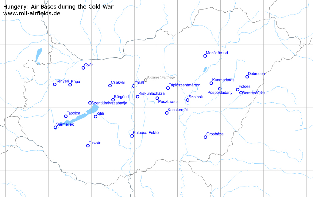
Hungarian airfields (29)
Berettyóújfalu: Airfield
Аэродром Береттьоуйфалу
For historical information only, do not use for navigation or aviation purposes!
| Coordinates | N471415 E0212833 (WGS84) Google Maps |
| Elevation | 322 ft |
Usage during the Cold War
Airfield of the Soviet forces.
Use today
Closed.
Runways
- 11/29: ~ 2800 m Grass
Sources
The location is shown on old TPC/ONC maps. It is also shown on a russian topographic map. On Google Earth (2009), the area is barely visible.
Airfields in the vicinity
Börgönd: Airfield
Borgond, Börgöndi repülőtér
For historical information only, do not use for navigation or aviation purposes!
| Coordinates | N470733 E0183006 (WGS84) Google Maps |
| Elevation | 404 ft |
| Location indicator | LHBD |
Usage during the Cold War
Helicopter base of Hungarian Air Force.
Use today
General aviation.
Runways
- 01/19 Grass
Airfields in the vicinity
- 301°/7km Székesfehérvár: Sóstó
- 348°/26km Csákvár: Airfield (Csákvári repülőtér, Аэродром Чаквар)
Budapest: Mátyásföld
Mátyásföldi repülőtér
For historical information only, do not use for navigation or aviation purposes!
| Coordinates | N472959 E0191201 (WGS84) Google Maps |
Usage until 1945
Budapest airfield.
Usage during the Cold War
Airfield of the Soviet forces.
Use today
Closed.
Csákvár: Airfield
Csákvári repülőtér, Аэродром Чаквар
For historical information only, do not use for navigation or aviation purposes!
| Coordinates | N472104 E0182551 (WGS84) Google Maps |
| Elevation | 486' |
Usage during the Cold War
Soviet? airfield.
Use today
Closed.
Runways
- 04/22: 2054 m x 19 m Concrete
Installations
Simple layout: relativly short and narrow runway, parallel taxiway, two small ramps, 12 open parking positions in the north.
Links
Airfields in the vicinity
Debrecen: Air Base
Debreceni repülőtér, Debrecen Airport, Аэродром Дебрецен
For historical information only, do not use for navigation or aviation purposes!
| Coordinates | N472921 E0213657 (WGS84) Google Maps |
| Elevation | 358 ft |
| Location indicator | LHDC |
Usage during the Cold War
Soviet air base.
Use today
Regional airport.
Runways
- 05R/23L: 2500 m x 40 m Concrete
- 05L/23R: 2300 m x 80 m Concrete Emergency
Radio communication
Call sign "GORJET" (ГОРЖЕТ) (Source: www.strizhi.ru)
Installations
Two parallel runways, circular taxiway, several shelter and open parking positions; railway line in the north.
Airfields in the vicinity
Esztergom
For historical information only, do not use for navigation or aviation purposes!
| Coordinates | N474527 E0184351 (WGS84) Google Maps |
Usage during the Cold War
Airfield of the Soviet forces.
Földes: Airfield
Foldes, Аэродром Фёльдеш
For historical information only, do not use for navigation or aviation purposes!
| Coordinates | N471715 E0212356 (WGS84) Google Maps |
| Elevation | 331 ft |
Location of airfield
East of Földes.
Usage during the Cold War
Reserve airfield.
Use today
Closed.
Runways
- 06/24: ca. 3000 m Grass
Sources
The location is show on old TPC/ONC maps. It is also shown on a russian topographic map. On Google Earth (2009), the area is barely visible. The military use is documented in the internet (see links).
Links
- http://forum.keypublishing.co.uk/showthread.php?t=... - Key Publishing Ltd Aviation Forums - Rough Field Capability 3rd sqn. of the 1 gv.apib. at Foldes
Airfields in the vicinity
Gyõr: Airfield
Győr–Pér repülőtér
For historical information only, do not use for navigation or aviation purposes!
| Coordinates | N473738 E0174832 (WGS84) Google Maps |
| Elevation | 420' |
| Location indicator | LHPR |
Usage during the Cold War
Reserve airfield?
Use today
General aviation.
Runways
- 12/30: ~2900 m Grass
Sources
The former military usage is described at the homepage of today's airport (see link section). The total length of nearly 3 km is another indicator for it.
Links
- http://www.gyor-perairport.hu/ - Homepage
Airfields in the vicinity
Kalocsa Foktö: Airfield
Kalocsai repülőtér, Fokto, Аэродром Калоча Фоктё
For historical information only, do not use for navigation or aviation purposes!
| Coordinates | N463312 E0185631 (WGS84) Google Maps |
| Elevation | 299' |
| Location indicator | LHKA |
Location of airfield
3 km northwest of Kalocsa.
Usage during the Cold War
Soviet helicopter base.
Use today
General aviation.
Runways
- 17/35: 2500 m x 60 m Concrete
Radio communication
Call sign "VERCHOVOD" (Quelle: www.strizhi.ru)
Installations
Runway with taxiways on both sides; more than 60 parking pads.
Airfields in the vicinity
- 356°/15km Madocsa
Kecskemét: Air Base
Titan
For historical information only, do not use for navigation or aviation purposes!
| Coordinates | N465503 E0194457 (WGS84) Google Maps |
| Elevation | 376 ft |
| Location indicator | LHKE |
Location of airfield
East-northeast of Kecskemét.
Usage during the Cold War
Hungarian Air Force base.
Use today
Hungarian Air Force base.
Runways
- 12/30: 2500 m x 60 m Concrete
Radio communication
Call sign "DALNOK" (Source: www.strizhi.ru)
Installations
The air base had two remote dispersal areas in the northeast.
Airfields in the vicinity
- 247°/11km Kecskemét: Kadafalva
- 327°/31km Pusztavacs: Airfield? (Örkény, Orkeny)
Kecskemét: Kadafalva
For historical information only, do not use for navigation or aviation purposes!
| Coordinates | N465246 E0193701 (WGS84) Google Maps |
Usage during the Cold War
Soviet helicopter base.
Use today
Closed.
Airfields in the vicinity
- 067°/11km Kecskemét: Air Base (Titan)
Kenyeri: Airfield
For historical information only, do not use for navigation or aviation purposes!
| Coordinates | N472216 E0170835 (WGS84) Google Maps |
| Elevation | 495 ft |
Location of airfield
4 km southeast of Kenyeri.
Usage during the Cold War
Reserve airfield with grass runway.
Use today
Closed.
Runways
- 16/34: ~2500 m Grass
Sources
The airfield is shown on old TPC/ONC maps with approx. 2700 m unpaved runway. On the internet, several sources report about periodical usage by the Hungarian Airforce. On Google Maps (2009), the area is good visible.
Links
- http://www.kenyeri.hu/pages/repter.php - History of the airfield With pictures from the last use in 1993.
- http://kameraaltal.blog.hu/2013/09/26/kenyeri_tart... - Kenyeri tartalék reptér Pictures
Airfields in the vicinity
Kiliti: Airfield
Siófok-Kiliti repülőtér, Balaton-Ságvár
For historical information only, do not use for navigation or aviation purposes!
| Coordinates | N465127 E0180544 (WGS84) Google Maps |
| Elevation | 420 ft |
| Location indicator | LHSK |
Location of airfield
Southeast of Balatonkiliti.
Usage during the Cold War
Reserve airfield with unpaved runway.
Use today
General aviation.
Runways
- 15/33: ~2900 m Grass
Sources
Die airfield is drawn on old TPC/ONC maps as "Balaton-Sagvar" with ca. 2500 m of unpaved runway. Several internet sources and the current homepage describe the frequent use by the Hungarian Airforce. One of the pages (see link sections) has pictures of MiG-21 at Kiliti.
Links
- http://forum.keypublishing.co.uk/showthread.php?t=... - Key Publishing Ltd Aviation Forums - Rough Field Capability Picture of MiG-21 of Hungarien Airforce at Kiliti 1981
Airfields in the vicinity
- 339°/26km Szentkiralyszabadja: Airfield (Veszprem, Szentkirály, Szentkirályszabadjai Repülőtér)
- 036°/42km Székesfehérvár: Sóstó
- 046°/43km Börgönd: Airfield (Borgond, Börgöndi repülőtér)
- 195°/53km Taszár: Air Base (Kaland)
- 271°/53km Tapolca: Airfield (Tapolcai repülőtér)
Kiskunlacháza: Air Base
Kiskunlacházi repülőtér, Аэродром Кишкунлацхаза
For historical information only, do not use for navigation or aviation purposes!
| Coordinates | N471038 E0190427 (WGS84) Google Maps |
| Elevation | 322 ft |
| Location indicator | LHKK |
Location of airfield
6 km southeast of Kiskunlacháza.
Usage during the Cold War
Soviet air base.
Use today
General aviation.
Runways
- 14/32: 2500 m
Radio communication
Call Sign "AMPER" (АМПЕР) (Source: www.strizhi.ru)
Installations
Several open parking pads and shelter west of the runway; shelter area in the northeast; railway from the northwest.
Airfields in the vicinity
Kunmadaras: Air Base
Kunmadarasi repülőtér, Аэродром Кунмадараш
For historical information only, do not use for navigation or aviation purposes!
| Coordinates | N472326 E0204702 (WGS84) Google Maps |
| Elevation | 300' |
| Location indicator | LHKM |
Location of airfield
5 km south of Kunmadaras.
Usage during the Cold War
Soviet airbase.
Use today
Closed, used as race track.
Runways
- 05/23: 2500 m
Radio communication
Rufzeichen "FOXTROTT" (ФОКСТРОТ) (Source: www.strizhi.ru)
Airfields in the vicinity
Madocsa
For historical information only, do not use for navigation or aviation purposes!
| Coordinates | N464115 E0185544 (WGS84) Google Maps |
Usage during the Cold War
Airfield of the Soviet forces (known for 1954).
Use today
Closed.
Airfields in the vicinity
Mezõkövesd: Airfield
Mezőkövesdi repülőtér, Mezokovesd, Klementina, Аэродром Мезёкёвешд
For historical information only, do not use for navigation or aviation purposes!
| Coordinates | N474857 E0203814 (WGS84) Google Maps |
Location of airfield
Ca. 5 km north-northeast of Mezõkövesd.
Usage during the Cold War
Reserve airfield.
Runways
- 05/23: 3500 m
Radio communication
Call sign "FALU" (ФАЛУ) (Source: www.strizhi.ru)
Installations
Simple Layout: long and wide runway, parallel taxiway, ramp in the southwest; railway from the north.
Airfields in the vicinity
Orosháza: Airfield
Аэродром Орошаза
For historical information only, do not use for navigation or aviation purposes!
| Coordinates | N463156 E0203855 (WGS84) Google Maps |
Usage during the Cold War
Reserve airfield.
Use today
Closed.
Runways
- 06/24: ~2700 m Grass
Sources
The airfield is drawn on old TPC/ONC maps. The military use is described in one of the internet sources (see link section).
Links
- http://forum.keypublishing.co.uk/showthread.php?t=... - Key Publishing Ltd Aviation Forums - Rough Field Capability 1973 1.gv.apib. Su-7Bs at Oroshaza
Pápa: Air Base
MH Pápa Bázisrepülőtér, Párduc
For historical information only, do not use for navigation or aviation purposes!
| Coordinates | N472150 E0173003 (WGS84) Google Maps |
| Elevation | 485 ft |
| Location indicator | LHPA |
Location of airfield
4 km northeast of Papa.
Usage during the Cold War
Hungarian Air Force base.
Use today
Hungarian Air Force airbase.
Runways
- 16/34: 2400 m x 58 m Concrete
Radio communication
Call sign "KERUT" (Source: www.strizhi.ru)
Installations
Dispersal areas in the northeastern and southeastern part of the air base.
Airfields in the vicinity
- 272°/27km Kenyeri: Airfield
- 038°/37km Gyõr: Airfield (Győr–Pér repülőtér)
Püspökladany: Airfield?
For historical information only, do not use for navigation or aviation purposes!
| Coordinates | N471801 E0205908 ? (WGS84) Google Maps |
| Elevation | 280' |
Location of airfield
10 km west-southwest of Püspökladany.
Usage during the Cold War
Reserve airfield?
Use today
Closed.
Sources
The airfield is shown on old TPC/ONC maps. On Google Earth (2009), an area is visible. But with a length of only 1800 m (ca.), it is unusual short, compared to other reserve airfields. The military use is described in one of the internet sources (see link section).
Links
- http://forum.keypublishing.co.uk/showthread.php?t=... - Key Publishing Ltd Aviation Forums - Rough Field Capability Summer 1988: 1 GvAPIB Su-17M2s at Puspokladany
Airfields in the vicinity
Pusztavacs: Airfield?
Örkény, Orkeny
For historical information only, do not use for navigation or aviation purposes!
| Coordinates | N470906 E0193142 (WGS84) Google Maps |
| Elevation | 449 ft |
Usage during the Cold War
Unknown.
Runways
- 13/31: ~2200 m Grass
Sources
The airfield is shown on old TPC/ONC maps as "Orkeny", with ca. 2400 m of unpaved runway. But the location is 7 km northeast of Örkény, southeast of Pusztavacs. The area is good visible on Google Earth (2009).
Airfields in the vicinity
Sármellek: Airfield
Balaton, Аэродром Шармеллек
For historical information only, do not use for navigation or aviation purposes!
| Coordinates | N464112 E0170934 (WGS84) Google Maps |
| Elevation | 408 ft |
| Location indicator | LHSM |
Usage during the Cold War
Soviet Air Force base.
Use today
Airport.
Runways
- 17/35: 2500 m x 60 m
Radio communication
Call sign "BENGAL" (ВЕНГАЛ) (Source: www.strizhi.ru)
Airfields in the vicinity
- 043°/27km Tapolca: Airfield (Tapolcai repülőtér)
Székesfehérvár: Sóstó
For historical information only, do not use for navigation or aviation purposes!
| Coordinates | N470935 E0182504 (WGS84) Google Maps |
Usage during the Cold War
Airfield of Soviet forces.
Use today
Closed.
Airfields in the vicinity
Szentkiralyszabadja: Airfield
Veszprem, Szentkirály, Szentkirályszabadjai Repülőtér
For historical information only, do not use for navigation or aviation purposes!
| Coordinates | N470441 E0175806 (WGS84) Google Maps |
| Elevation | 919 ft |
| Location indicator | LHSA |
Runways
- 16/34: 2000 m x 60 m Asphalt
Airfields in the vicinity
- 158°/26km Kiliti: Airfield (Siófok-Kiliti repülőtér, Balaton-Ságvár)
- 075°/35km Székesfehérvár: Sóstó
- 082°/41km Börgönd: Airfield (Borgond, Börgöndi repülőtér)
- 049°/46km Csákvár: Airfield (Csákvári repülőtér, Аэродром Чаквар)
- 312°/47km Pápa: Air Base (MH Pápa Bázisrepülőtér, Párduc)
- 241°/49km Tapolca: Airfield (Tapolcai repülőtér)
Szolnok: Airfield
Opera, Szolnok Helikopter Bázis
For historical information only, do not use for navigation or aviation purposes!
| Coordinates | N470723 E0201409 (WGS84) Google Maps |
| Elevation | 292 ft |
| Location indicator | LHSN |
Use today
Air Base.
Radio communication
Call sign "BASCHLEMES" (Source: www.strizhi.ru)
Airfields in the vicinity
Tápiószentmárton: Airfield
Tápióbicskei repülőtér, Аэродром Тапиосентмартон, "Тапио"
For historical information only, do not use for navigation or aviation purposes!
| Coordinates | N471838 E0194629 (WGS84) Google Maps |
| Elevation | 344 ft |
Location of airfield
3 km southeast of Tápiószentmárton.
Usage during the Cold War
Soviet reserve airfield.
Use today
General aviation.
Runways
- 13/31: ~2500 m Grass
Sources
The airfield is shown on old TPC/ONC maps, with ca. 2400 m of unpaved runway. The military use is described on the internet (see link section).
Links
- http://forum.keypublishing.co.uk/showthread.php?t=... - Key Publishing Ltd Aviation Forums - Rough Field Capability July 17 1984: 515 IAP with MiG-21 at Tápioszentmárton
Airfields in the vicinity
- 227°/26km Pusztavacs: Airfield? (Örkény, Orkeny)
- 121°/41km Szolnok: Airfield (Opera, Szolnok Helikopter Bázis)
- 183°/44km Kecskemét: Air Base (Titan)
- 296°/48km Budapest: Mátyásföld (Mátyásföldi repülőtér)
- 194°/49km Kecskemét: Kadafalva
Tapolca: Airfield
Tapolcai repülőtér
For historical information only, do not use for navigation or aviation purposes!
| Coordinates | N465153 E0172415 (WGS84) Google Maps |
| Elevation | 351 ft |
Usage during the Cold War
Possibly reserve airfield.
Use today
Closed.
Runways
- 17/35: ~3000 m Grass
Sources
The airfield is shown on old TPC/ONC maps, with ca. 2600 m unpaved runway. On Google Earth (2009), the area is good visible.
Airfields in the vicinity
Taszár: Air Base
Kaland
For historical information only, do not use for navigation or aviation purposes!
| Coordinates | N462334 E0175458 (WGS84) Google Maps |
| Elevation | 526 ft |
| Location indicator | LHTA |
Usage during the Cold War
Hungarian Air Force base.
Use today
Closed.
Runways
- 16/34: 2500 m x 60 m Concrete
Radio communication
Call sign "ZELESEG" (Source: www.strizhi.ru)
Installations
Parallel runway, several open parking positions, remote sites in the northwest and northeast.
Airfields in the vicinity
Tököl: Air Base
Tököli repülőtér, Tokol, Аэродром Тёкёль
For historical information only, do not use for navigation or aviation purposes!
| Coordinates | N472043 E0185851 (WGS84) Google Maps |
Usage during the Cold War
Soviet air base.
Runways
- 14/32: 2500 m x 80 m
Radio communication
Call Sign "BOLJANKA" (БОЛЖАНКА) (Source: www.strizhi.ru)
Links
- http://www.strizhi.ru/cgi-bin/yabb/YaBB.pl?num=113... - 515 ИАП Тёкёль Many Stories and pictures from the soviet times at Tököl (russian forum)
Airfields in the vicinity
- 159°/20km Kiskunlacháza: Air Base (Kiskunlacházi repülőtér, Аэродром Кишкунлацхаза)
- 044°/24km Budapest: Mátyásföld (Mátyásföldi repülőtér)
- 271°/41km Csákvár: Airfield (Csákvári repülőtér, Аэродром Чаквар)
- 236°/44km Börgönd: Airfield (Borgond, Börgöndi repülőtér)
- 117°/47km Pusztavacs: Airfield? (Örkény, Orkeny)
- 244°/47km Székesfehérvár: Sóstó
- 338°/50km Esztergom
Glossary
The following terms might help you for your own research on search engines. I'm not an expert for hungarian, so it is without warranty. Corrections and additions are welcome!
Hungarian
| Airfield | repülés, repülõtér |
| Airfields | repülõtérek |
| Military airfield | katonai reptér |
| Paramilitary organisation | MHSZ Magyar Honvédelmi Szövetség |
| soviet | szovjet |
Russian
| Airfield | аэродром |
| Airport | аэропорт |
| Call sign | позывной |
| Hungary | Венгрия |