Austria: Air Bases and Military Airfields
For historical information only, do not use for navigation or aviation purposes!
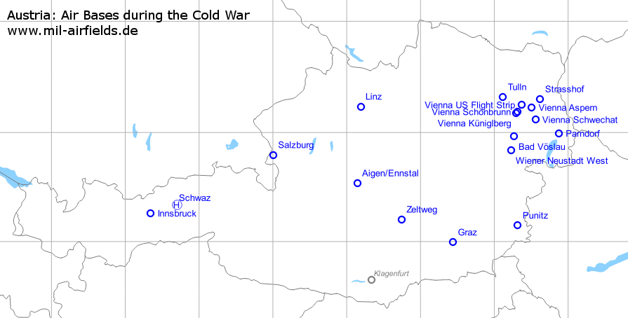
Military airfields in Austria (19)
Aigen/Ennstal
Fiala-Fernbrugg Air Base
For historical information only, do not use for navigation or aviation purposes!
| Coordinates | N473209 E0140829 (WGS84) Google Maps |
| Elevation | 2093' |
| Location indicator | LOXA |
Usage until 1945
Military airfield.
Use today
Military airfield.
Units
Hubschraubergeschwader (1990)
Bibliography
- Ries, Karl; Dierich, Wolfgang: "Fliegerhorste und Einsatzhäfen der Luftwaffe" Motorbuch Verlag Stuttgart, 1993 - Allied map
Allentsteig
For historical information only, do not use for navigation or aviation purposes!
Location of airfield
Exact location unknown.
Usage during the Cold War
Helipad on training area, used for border patrol flights.
Bad Vöslau: Airfield
For historical information only, do not use for navigation or aviation purposes!
| Coordinates | N475753 E0161538 (WGS84) Google Maps |
General
Between 1945 and 1955, Bad Vöslau airfield was used by the Soviet occupation force. Thereafter general aviation.
Links
- http://www.bildarchivaustria.at/Pages/ImageDetail.... - Image: Soviet passenger aircraft with the Austrian delegation arriving from Moscow at Vöslau airfield (Il-14)
- http://www.bildarchivaustria.at/Pages/ImageDetail.... - Image: Arrival of the Austrian delegation at Vöslau airfield (Aircraft tail with tail number)
- http://www.bildarchivaustria.at/Pages/ImageDetail.... - Image: Waiting for Molotov - Soviet officers at the Vöslau airfield. Pastimes by playing chess (May 1955)
- http://www.bildarchivaustria.at/Pages/ImageDetail.... - Image: Molotov arriving for the signing of the Austrian State treaty.
- http://www.bildarchivaustria.at/Pages/ImageDetail.... - Image: Molotov arriving at Vöslau airfield (Il-14)
- http://www.bildarchivaustria.at/Pages/ImageDetail.... - Image: Soviet foreign minister Molotov arrives at Bad Voeslau airport for final talks with the Austrian government. He is greeted by Austrian Foreign Minister Leopold Figl. Vienna, 1955 (Aircraft tail with tail number)
Videos
- http://www.mediathek.at/atom/1308B005-379-0005B-00... - Video: The Austrian delegation is leaving for Moscow (April 1955)
Airfields in the vicinity
Graz: Thalerhof Airport
Nitter Air Base
For historical information only, do not use for navigation or aviation purposes!
| Coordinates | N465929 E0152622 (WGS84) Google Maps |
| Elevation | 1115' |
| Location indicator | LOWG (civ), LOXG (mil, -201x) |
Location of airfield
The airport is located ca. 7 km south of Graz.
Usage until 1945
Air base.
Usage during the Cold War
Airport and air base. The military installations were in the southwest of the airfield.
Use today
Airport.
Runways
Angaben für das Jahr 1990:
- 17/35: 640 m x 30 m Grass
- 17/35: 2760 m x 45 m Concrete
- 17/35: 760 m x 25 m Grass
Bibliography
- Ries, Karl; Dierich, Wolfgang: "Fliegerhorste und Einsatzhäfen der Luftwaffe" Motorbuch Verlag Stuttgart, 1993 - Allied map
Innsbruck: Airport
Kranebitten
For historical information only, do not use for navigation or aviation purposes!
| Coordinates | N471537 E0112040 (WGS84) Google Maps |
| Elevation | 1900 ft |
| Location indicator | LOWI |
General
The Innsbruck airfield was built after World War II for the French Air Force. Since the withdrawal of the occupation troops in 1955, it is used as an airport. Nevertheless, a safety position for armed aircrafts is still established at the airfield.
In the 1950s
Use
French Air Force base.
Runways
- East/West: 1100 m x 50 m Concrete
- East/West: 1280 m x 46 m Grass
Radio beacons
- NDB: 278 "OEJ", 127°/3.0 NM to field; power: 1 kW.
Radio communication
- Tower 118.3, 3023.5
Airspace and procedures
The airfield was operated from sunrise to sunset.
Today
Use
Airport.
Airfields in the vicinity
- 073°/28km Schwaz: Helipad
Linz: Hörsching Airport
Vogler Air Base
For historical information only, do not use for navigation or aviation purposes!
| Coordinates | N481400 E0141115 (WGS84) Google Maps |
| Elevation | 978' |
| Location indicator | LOWL, LOXL |
Location of airfield
The airfield is located ca. 10 km southwest of Linz.
Usage until 1945
Air base.
Usage during the Cold War
Airport and air base.
Runways
Data for the year 1990:
- 09/27: 660 m x 45 m Grass
- 09/27: 2810 m x 60 m Concrete
Bibliography
- Ries, Karl; Dierich, Wolfgang: "Fliegerhorste und Einsatzhäfen der Luftwaffe" Motorbuch Verlag Stuttgart, 1993 - Allied map
Parndorf: Air Base
Аэродром Парндорф
For historical information only, do not use for navigation or aviation purposes!
| Coordinates | N475926 E0165227 (WGS84) Google Maps |
Usage until 1945
Luftwaffe airfield.
Usage during the Cold War
Soviet air base until the 1950s.
Use today
Closed.
Airfields in the vicinity
- 301°/27km Vienna: Schwechat Airport (Wien)
Punitz
For historical information only, do not use for navigation or aviation purposes!
| Coordinates | N470849 E0161901 (WGS84) Google Maps |
| Location indicator | LOGG |
Location
Punitz is located ca. 70 km east of Graz, 10 km from the Hungarian border.
Use today
General aviation and helipad for border patrol flights
Links
- http://www.bmlv.gv.at/cms/artikel.php?ID=4219 - Ablöse am Himmel über dem Burgenland
Salzburg: Airport
For historical information only, do not use for navigation or aviation purposes!
| Coordinates | N474738 E0130013 (WGS84) Google Maps |
| Location indicator | LOWS |
General
After World War II until the withdrawal of the occupation troops in 1955, Salzburg was used by the US Air Force. Since then airport for Salzburg. At the southern edge of the apron, a safety position for armed aircraft was still established.
In the early 1950s
Use
US Air Force base.
Overview
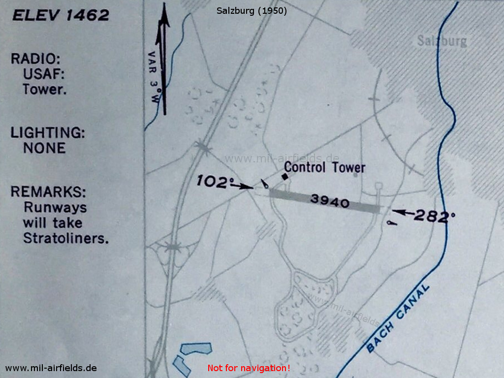
Salzburg as USAF airfield in 1950
Radio communication
- Tower 3023.5, 118.1, 121.5
The tower was operating between 0700 and 1700 and on request outside these times.
Airspace and procedures
The field was open to USAF aircraft only;
operating times: working days 0700-1600
operating times: working days 0700-1600
Schwaz: Helipad
For historical information only, do not use for navigation or aviation purposes!
| Coordinates | N472006 E0114151 (WGS84) Google Maps |
| Location indicator | LOXS |
Location
Schwaz is located ca. 20 km east-northeast of Innsbruck.
Use today
Heliport.
Airfields in the vicinity
- 253°/28km Innsbruck: Airport (Kranebitten)
Strasshof: Airfield
Deutsch-Wagram
For historical information only, do not use for navigation or aviation purposes!
| Coordinates | N481802 E0163715 (WGS84) Google Maps |
General
Strasshof started as a Luftwaffe airbase in World War II. From 1945 until presumably 1955, the airfield was used by Soviet troops.
Runways
- 13/31: 2300 m
Links
- http://www.austrianaviation.net/fileadmin/html/fea... - Der vergessene Flughafen Strasshof
Airfields in the vicinity
- 226°/12km Vienna: Aspern Airfield
- 253°/19km Vienna: US Flight Strip (Wien)
- 193°/21km Vienna: Schwechat Airport (Wien)
- 241°/26km Vienna: Schönbrunn Airstrip (Wien)
- 241°/28km Vienna: Küniglberg Airstrip (Wien)
Tulln: Air Base
Langenlebarn, Brumowski
For historical information only, do not use for navigation or aviation purposes!
| Coordinates | N481910 E0160654 (WGS84) Google Maps |
| Elevation | 575 ft |
| Location indicator | LOXT |
General
Nach dem Zweiten Weltkrieg in der sowjetischen Zone gelegen, wurde der Flugplatz von US-Truppen genutzt. Nach dem Abzug der Besatzungstruppen 1955 ging der Platz an des Österreichische Bundesheer über, den ihn auch heute nutzt.
Location
Tulln is located ca.25 km west-northwest of Vienna.
Location of airfield
The airfield is located ca. 3 km east-southeast of Tulln.
Usage until 1945
Military airfield.
Overview
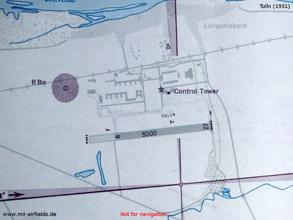
US airfield Tulln in 1951
Runways
Data for the year 1990:
- 08/26
Links
- http://www.usarmygermany.com/Units/USFA%20Units/Te... - Tulln Air Base Telephone Directory 1947
- http://www.turbo.at/geheimprojekte/t_lale.html - Langenlebarn / Tulln - Fliegerhorst History
Bibliography
- Ries, Karl; Dierich, Wolfgang: "Fliegerhorste und Einsatzhäfen der Luftwaffe" Motorbuch Verlag Stuttgart, 1993 - Alliierte Planskizze
Airfields in the vicinity
- 112°/20km Vienna: US Flight Strip (Wien)
- 140°/20km Vienna: Küniglberg Airstrip (Wien)
- 135°/21km Vienna: Schönbrunn Airstrip (Wien)
Vienna: Aspern Airfield
For historical information only, do not use for navigation or aviation purposes!
| Coordinates | N481333 E0163023 (WGS84) Google Maps |
| Location indicator | LOWA |
General
Until 1945 airport and air base. From 1945 until presumably 1955 used by Soviet troops. After the withdrawal of the occupation troops until 1977 general aviation, thereafter closed.
Links
- https://de.wikipedia.org/wiki/Flughafen_Aspern - Aspern Airport (German Language)
Airfields in the vicinity
- 284°/10km Vienna: US Flight Strip (Wien)
- 046°/12km Strasshof: Airfield (Deutsch-Wagram)
- 163°/13km Vienna: Schwechat Airport (Wien)
- 253°/15km Vienna: Schönbrunn Airstrip (Wien)
- 251°/17km Vienna: Küniglberg Airstrip (Wien)
Vienna: Küniglberg Airstrip
Wien
For historical information only, do not use for navigation or aviation purposes!
| Coordinates | N481039 E0161727 ca. (WGS84) Google Maps |
Usage during the Cold War
British strip for light aircraft from 1951 to 1955. Source: /Wikipedia/
Links
- /Wikipedia/:
https://de.wikipedia.org/wiki/Flugpl%C3%A4tze_in_W... - Flugplätze in Wien
Airfields in the vicinity
- 058°/2km Vienna: Schönbrunn Airstrip (Wien)
- 036°/10km Vienna: US Flight Strip (Wien)
- 071°/17km Vienna: Aspern Airfield
- 321°/20km Tulln: Air Base (Langenlebarn, Brumowski)
- 109°/21km Vienna: Schwechat Airport (Wien)
Vienna: Schönbrunn Airstrip
Wien
For historical information only, do not use for navigation or aviation purposes!
| Coordinates | N481113 E0161848 ca. (WGS84) Google Maps |
Location of airfield
Between Schönbrunn Palace and Wien River. Source: /Wikipedia/
Usage during the Cold War
British airstrip from 1945 until 1955. Quelle: /Wikipedia/
Links
- /Wikipedia/:
https://de.wikipedia.org/wiki/Flugpl%C3%A4tze_in_W... - Flugplätze in Wien
Airfields in the vicinity
- 238°/2km Vienna: Küniglberg Airstrip (Wien)
- 031°/8km Vienna: US Flight Strip (Wien)
- 073°/15km Vienna: Aspern Airfield
- 114°/20km Vienna: Schwechat Airport (Wien)
- 315°/21km Tulln: Air Base (Langenlebarn, Brumowski)
Vienna: Schwechat Airport
Wien
For historical information only, do not use for navigation or aviation purposes!
| Coordinates | N480657 E0163320 (WGS84) Google Maps |
| Location indicator | LOWW |
Usage during the Cold War
Royal Air Force (RAF) airfield until the 1950s.
In the 1950s
Use
Airfield of the Royal Air Force (RAF).
Overview
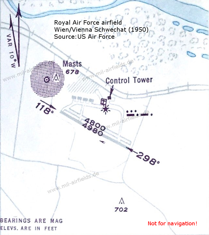
Map from 1950 - South of the control tower is the red flashing light, which is typical for british military airfields- in Vienna with the morse code "SC". The dotted circled area in the northwest is the Non-Directional Beacon (NDB) with ident "OEW".
Runways
- 12/30: 1518 m
Lights
Red flashing light with code SC.
Radio beacons
- NDB: 408 "OEW", at field
- Eureka (british radio navigation system)
- SBA (Standard Beam Approach)
Today
Use
Airport.
Airfields in the vicinity
- 343°/13km Vienna: Aspern Airfield
- 294°/20km Vienna: Schönbrunn Airstrip (Wien)
- 317°/20km Vienna: US Flight Strip (Wien)
- 013°/21km Strasshof: Airfield (Deutsch-Wagram)
- 289°/21km Vienna: Küniglberg Airstrip (Wien)
- 120°/27km Parndorf: Air Base (Аэродром Парндорф)
- 233°/28km Bad Vöslau: Airfield
Vienna: US Flight Strip
Wien
For historical information only, do not use for navigation or aviation purposes!
| Coordinates | N481457 E0162211 (WGS84) Google Maps |
General
US Army landing ground in Vienna after World War II. Presumably closed with the withdrawal of the occupation troops in 1955.
Links
- http://www.usarmygermany.com/Units/Army%20Aviation... - USArmyGermany.com
Airfields in the vicinity
- 211°/8km Vienna: Schönbrunn Airstrip (Wien)
- 104°/10km Vienna: Aspern Airfield
- 216°/10km Vienna: Küniglberg Airstrip (Wien)
- 073°/19km Strasshof: Airfield (Deutsch-Wagram)
- 137°/20km Vienna: Schwechat Airport (Wien)
- 293°/20km Tulln: Air Base (Langenlebarn, Brumowski)
Wiener Neustadt: West
Аэродром Винер-Нойштадт
For historical information only, do not use for navigation or aviation purposes!
| Coordinates | N475016 E0161322 (WGS84) Google Maps |
| Elevation | 935 ft |
| Location indicator | LOXN |
General
Bis 1945 Flugplatz und Fliegerhorst. Mit dem Ende des Zweiten Weltkriegs wurde Wiener Neustadt eine Basis der sowjetischen Luftstreitkräfte, die den Platz bis zum Abzug im Jahre 1955 nutzten. Danach ging der Flugplatz an das Österreichische Bundesheer über, das ihn noch heute betreibt.
Location
Wiener Neustadt is located ca. 45 km south of Vienna.
Location of airfield
The airfield is located ca. 3 km north-northwest of Wiener Neustadt.
Usage until 1945
Air base.
Runways
Data for the year 1990:
- 18/36 Grass
Links
- http://www.aviator.at/airport/1loxn.htm - Information
- http://www.panoramio.com/photo/6147319 - Aerial picture
- http://www.panoramio.com/photo/6147313 - Aerial picture
Bibliography
- Ries, Karl; Dierich, Wolfgang: "Fliegerhorste und Einsatzhäfen der Luftwaffe" Motorbuch Verlag Stuttgart, 1993 - Allied map
Airfields in the vicinity
- 011°/14km Bad Vöslau: Airfield
Zeltweg: Hinterstoisser Air Base
For historical information only, do not use for navigation or aviation purposes!
| Coordinates | N471209 E0144437 (WGS84) Google Maps |
| Elevation | 2220 ft |
| Location indicator | LOXZ |
Usage until 1945
Air base.
In the 1980s
Runways
- 08/26: 1600 m (5249 ft) x 80 m (262 ft) Asphalt
Radio beacons
- NDB: 418 "ZW", at field
Radio communication
- Approach 129.15, 135.05
- Tower 118.7, 132.65
Today
Use today
Air base.
Recommended

Image credits are shown on the respective target page, click on the preview to open it.
 mil-airfields.de at Facebook