Radio beacons in Denmark in the 1950s
Radiofyr stationer i Danmark i 1950'erne - NDB, Range, ILS
For historical information only, do not use for navigation or aviation purposes!
The following list contains the aeronautical radio beacons that were active in Denmark in the mid of the 1950s. All information is outdated and may not be used for navigational purposes.
At this time there were mainly non-directional beacons (NDB). The identification of most en-route beacons consisted of three letters and began with an O. Other radio beacons, especially those for the approach to airfields, had two letters, mostly according to the name of the airfield.
Copenhagen Kastrup airport was equipped with the Instrument Landing System (ILS).
Radio beacons and airways
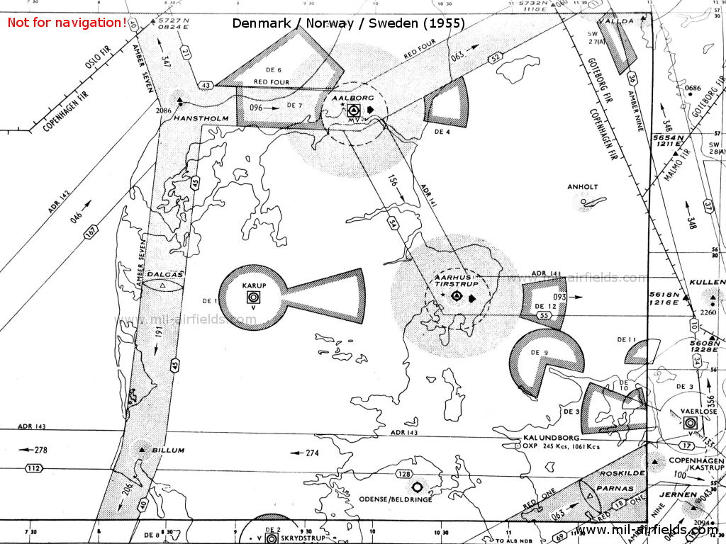
Northern parts of Jutland, Funen, Zealand (Source: DoD)
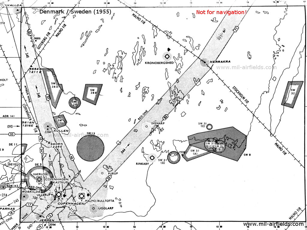
Zealand with Copenhagen (bottom left) (Source: DoD)
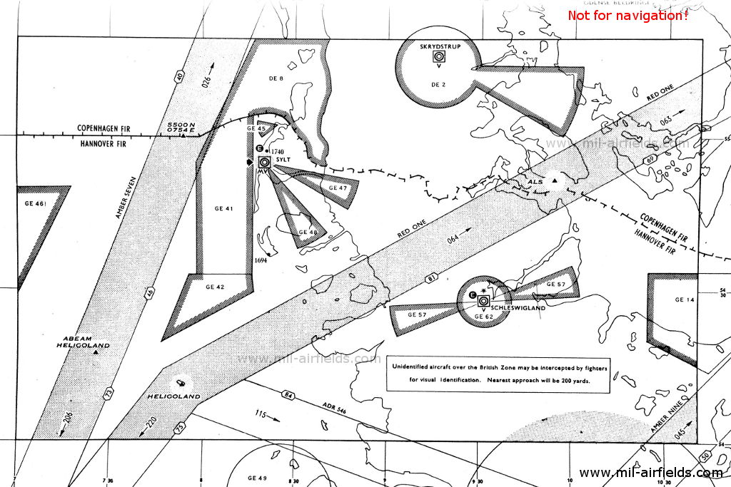
Southern parts of Jutland and Funen (Source: DoD)
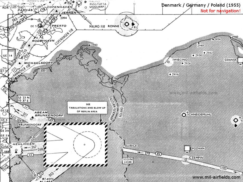
Funen, Zealand, Lolland, Falster, Bornholm (top) (Source: DoD)
Explanations
![]()
Abbreviations
| approx. | approximately | |
| civ | civil | civil operator |
| GP | Glide path | Glide path transmitter |
| ILS | Instrument Landing System | (Approach and landing aid) |
| IM | Inner Marker | Marker beacon just in front the runway |
| kHz | Kilohertz | (Unit for frequency) |
| L | Locator | Non-directional beacon for the approach |
| LLZ | Localizer | Localizer transmitter |
| LMM | Locator Middle Marker | Combination of Middle Marker and Locator |
| LOM | Locator Outer Marker | Combination of Outer Marker and Locator |
| m | Meter | (Unit for length) |
| MHz | Megahertz | (Unit for frequency) |
| mil | military | military operator |
| MM | Middle Marker | Marker beacon |
| NDB | Non-directional beacon | Non-directional beacon on long or medium waves |
| NM | Nautical Miles | (Unit for length) |
| OM | Outer Marker | Marker beacon |
| PRMG | ПРМГ Посадочная радиомаячная группа | Soviet / russian military instrument landing system |
| RSBN | РСБН Rадиотехническая система ближней навигации | Soviet / russian military radio navigation system |
| SBA | Standard Beam Approach | Approach system, Lorenz system, predecessor of the ILS |
| THR | Threshold | Runway threshold (most often with number of runway) |
| transf. | transformed | Coordinates were converted from a different reference system, therefore there may be deviations. |
| VAR | Visual-Aural Rnange | |
| VOR | VHF Omnidirectional Radio Range | |
| W | Watt | (Unit for power) |
| WGS84 | World Geodetic System 1984 | (geospatial reference system, GPS coordinates) |
Directory
For historical information only, do not use for navigation or aviation purposes!
Aalborg: Air Base (Flyvestation Aalborg, Aalborg Lufthavn)
Runway 27:
Aalborg: ILS 27
Channel Y. To runway 27 (269°).
Aalborg: NDB
N5706 E00955 (approx.), 268°/1.4 NM to field Google Maps
OZJ, 325 kHz
N5706 E00955 (approx.), 268°/1.4 NM to field Google Maps
OZJ, 325 kHz
Located about 2 km east of the main runway.
Aalborg: MM 27
Dot Dash, 75 MHz
Dot Dash, 75 MHz
Aalborg: IM 27
Dots, 75 MHz
Dots, 75 MHz
Tirstrup: Air Base (Flughafen Aarhus, Tirstrup Lufthavn)
For historical information only, do not use for navigation or aviation purposes!
Hanstholm: NDB
N5707 E00836 (approx.) Google Maps
OWM, 361.5 kHz
N5707 E00836 (approx.) Google Maps
OWM, 361.5 kHz
At the intersection of airways Amber Seven (A7) and Red Four (R4).
Jernen: NDB
N5524 E01219 (approx.), 043°/16.9 to Copenhagen Katrup Google Maps
JN, 369 kHz
N5524 E01219 (approx.), 043°/16.9 to Copenhagen Katrup Google Maps
JN, 369 kHz
On airway Amber Nine (A9).
Copenhagen: Kastrup Airport (Københavns Lufthavn)
København: Saltholm Flak Locator
N5542 E01244 (approx.), 209°/5.4 NM to field Google Maps
SF, 391 kHz
N5542 E01244 (approx.), 209°/5.4 NM to field Google Maps
SF, 391 kHz
At Saltholm Flak island.
Runway 04:
København: Range
N5535 E01237 (approx.), 044°/1.2 NM to field Google Maps
CH, 267.5 kHz
N5535 E01237 (approx.), 044°/1.2 NM to field Google Maps
CH, 267.5 kHz
The four predefined courses to the Range were: 044°, 134°, 224° and 314°.
Runway 12:
København: Amager Locator
N5540 E01226 (approx.), 115°/8.54 NM to field Google Maps
BL, 320 kHz
N5540 E01226 (approx.), 115°/8.54 NM to field Google Maps
BL, 320 kHz
Previous ident: NW.
København: ILS 12
OXS2, 109.9 MHz
OXS2, 109.9 MHz
København: OM 12
125°/3.85 NM to THR 12
Dashes, 75 MHz
125°/3.85 NM to THR 12
Dashes, 75 MHz
København: LMM 12
N5538 E01237 (approx.), 125°/1.08 NM to THR 12 Google Maps
Locator: L, 398 kHz
Middle Marker: Dot Dash, 75 MHz
N5538 E01237 (approx.), 125°/1.08 NM to THR 12 Google Maps
Locator: L, 398 kHz
Middle Marker: Dot Dash, 75 MHz
København: IM 13
125°/0.32 NM to THR 12
Dots, 75 MHz
125°/0.32 NM to THR 12
Dots, 75 MHz
Runway 22:
København: ILS 22
OXS, 109.1 MHz
OXS, 109.1 MHz
København: LMM 22
N5538 E01241 (approx.), 227°/1.18 NM to THR 22 Google Maps
Locator: K, 398 kHz
Middle Marker: Dot Dash, 75 MHz
N5538 E01241 (approx.), 227°/1.18 NM to THR 22 Google Maps
Locator: K, 398 kHz
Middle Marker: Dot Dash, 75 MHz
At Nordre Røse.
København: IM 22
227°/0.04 NM to THR 22
Dots, 75 MHz
227°/0.04 NM to THR 22
Dots, 75 MHz

Copenhagen Kastrup Airport with radio beacons in 1951 - The range with its four predefined courses was located southwest of the field. (Source: DoD)
Mygenaes: NDB
N6206 W00740 (approx.) Google Maps
MY, 291.9 kHz
N6206 W00740 (approx.) Google Maps
MY, 291.9 kHz
Mykineshólmur, Faroe Islands (Færøerne/Føroyar). Operated in clear weather H+00, in fog H+00 and every 6 minutes.
Narsarsuaq: Airport (Narsarssuak Air Base)
Narsarssuak: NDB
N611010 W0452545 (WGS84, transf.) Google Maps
BW, 279 kHz
N611010 W0452545 (WGS84, transf.) Google Maps
BW, 279 kHz
Greenland (Grønland). The location of the beacon was indicated as on the other side of the water in the north of the airfield - I wonder if this is correct.
Nolsa: NDB
N6157 W00636 (approx.) Google Maps
NO, 291.9 kHz
N6157 W00636 (approx.) Google Maps
NO, 291.9 kHz
Nólsoy (Nolsø), Faroe Islands (Færøerne/Føroyar). Operated in clear weather H+02, 08, in fog H+02 and every 6 minutes.
Odense: Airport (Odense Lufthavn, Beldringe Lufthavn)
For historical information only, do not use for navigation or aviation purposes!
Præstø: Presto Marker
N5509 E01159 (approx.) Google Maps
75 MHz
N5509 E01159 (approx.) Google Maps
75 MHz
On airway Amber Nine (A9) between Jernen and Rødbyhavn.
Rødbyhavn: NDB
N5439 E01121 (approx.) Google Maps
RY, 328 kHz
N5439 E01121 (approx.) Google Maps
RY, 328 kHz
On airway Amber Nine (A9) between Presto and Michaelsdorf.
Rønne: Airport (Bornholms Lufthavn, Roenne)
Rønne: NDB
N5503 E01448 (approx.), 294°/1.6 NM to field Google Maps
OZO, 325 kHz
N5503 E01448 (approx.), 294°/1.6 NM to field Google Maps
OZO, 325 kHz
Operated from 0330 to 0900 and from 1500 to 1900.
Simiutaq: NDB
090°/44.9 NM to Narsarssuak Air Base
SI, 359 kHz
090°/44.9 NM to Narsarssuak Air Base
SI, 359 kHz
Simiutaq: Racon (USAF)
N6041 W04631 (approx.) Google Maps
2-1-1-2, 9310 MHz
N6041 W04631 (approx.) Google Maps
2-1-1-2, 9310 MHz
Operated continuously.
Greenland (Grønland)
Kangerlussuaq: Airport (Søndre Strømfjord, Søndrestrom Air Base)
Søndrestrom: Racon (USAF)
N6701 W05041 (approx.) Google Maps
2-2-1-1, 9310 MHz
N6701 W05041 (approx.) Google Maps
2-2-1-1, 9310 MHz
Located at field. Limited to 40 miles in north and south quadrants due to adverse terrain conditions.
Greenland (Grønland)
For historical information only, do not use for navigation or aviation purposes!
Thule: Air Base
Thule: Racon (USAF)
N7631 W06842 (approx.), 070°/0.7 NM to field Google Maps
1-2-1-1, 9310 MHz
N7631 W06842 (approx.), 070°/0.7 NM to field Google Maps
1-2-1-1, 9310 MHz
Operated continuously. Caution: Mast 1,797 feet ASL located approximately 4 miles northeast of beacon.
Greenland (Grønland)
For historical information only, do not use for navigation or aviation purposes!
Maps
Not all labels are shown