Historical radio beacons, Sweden 1950s
Radiofyrar i Sverige på 1950-talet - NDB, ILS
For historical information only, do not use for navigation or aviation purposes!
The following list contains the aeronautical radio beacons that were active in Sweden in the mid of the 1950s. All information is outdated and may not be used for navigational purposes.
In this time there were predominantly non-directional radio beacons (NDB). Ranges became less, but the first VORs came up.
The list in incomplete, as most of the military radio beacons (NDB, Eureka/Anita, BABS/Barbro) are missing
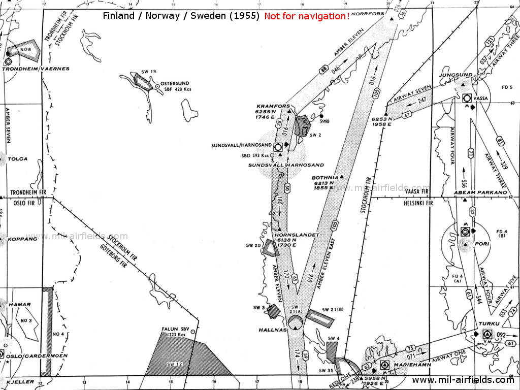
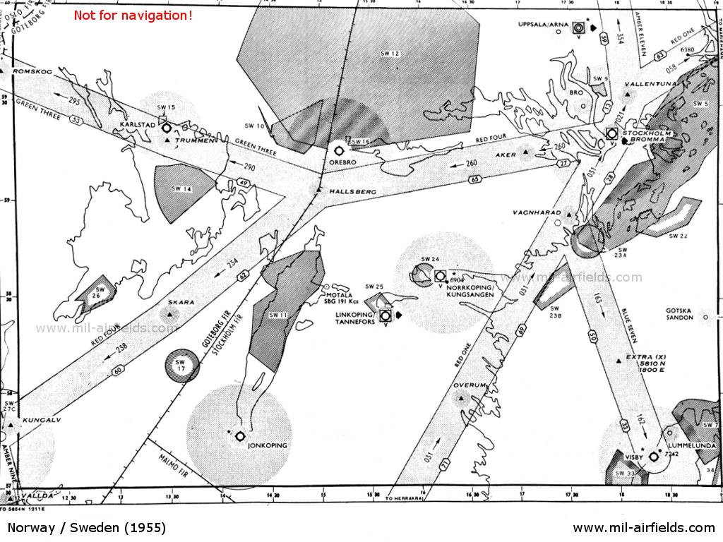
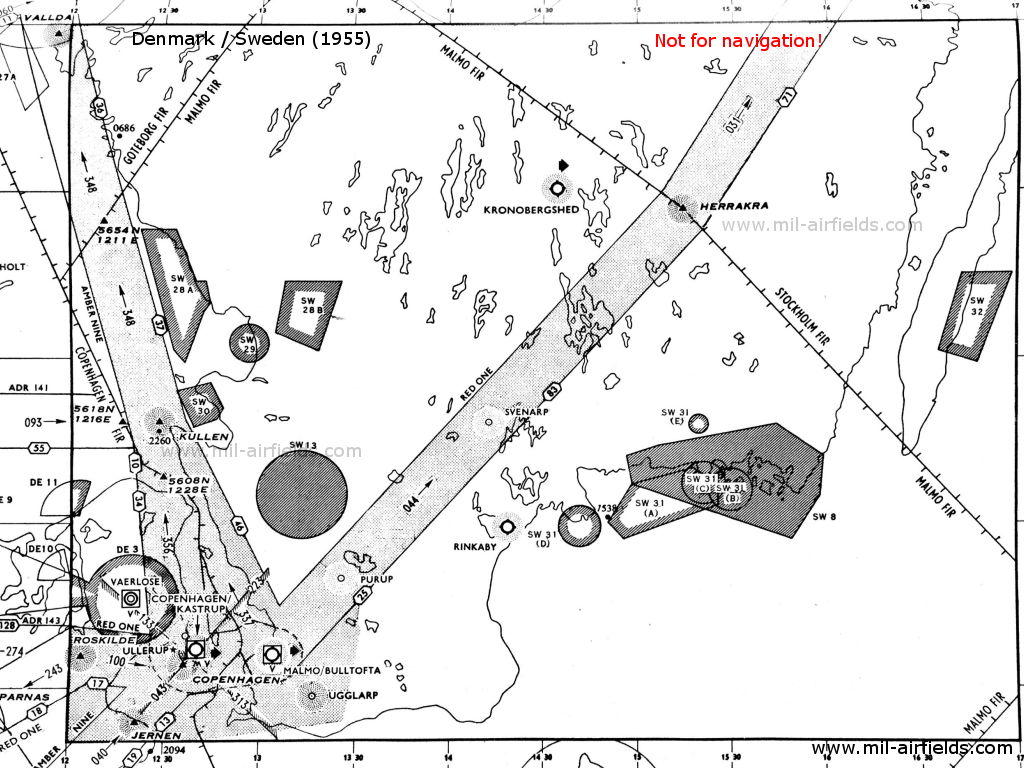
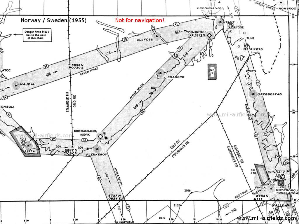
Radio beacons and airways
1 (Source: DoD)
2 (Source: DoD)
3 (Source: DoD)
4 (Source: DoD)
5 (Source: DoD)
Explanations
![]()
Abbreviations
| approx. | approximately | |
| civ | civil | civil operator |
| GP | Glide path | Glide path transmitter |
| ILS | Instrument Landing System | (Approach and landing aid) |
| IM | Inner Marker | Marker beacon just in front the runway |
| kHz | Kilohertz | (Unit for frequency) |
| L | Locator | Non-directional beacon for the approach |
| LLZ | Localizer | Localizer transmitter |
| LMM | Locator Middle Marker | Combination of Middle Marker and Locator |
| LOM | Locator Outer Marker | Combination of Outer Marker and Locator |
| m | Meter | (Unit for length) |
| MHz | Megahertz | (Unit for frequency) |
| mil | military | military operator |
| MM | Middle Marker | Marker beacon |
| NDB | Non-directional beacon | Non-directional beacon on long or medium waves |
| NM | Nautical Miles | (Unit for length) |
| OM | Outer Marker | Marker beacon |
| PRMG | ПРМГ Посадочная радиомаячная группа | Soviet / russian military instrument landing system |
| RSBN | РСБН Rадиотехническая система ближней навигации | Soviet / russian military radio navigation system |
| SBA | Standard Beam Approach | Approach system, Lorenz system, predecessor of the ILS |
| THR | Threshold | Runway threshold (most often with number of runway) |
| transf. | transformed | Coordinates were converted from a different reference system, therefore there may be deviations. |
| VAR | Visual-Aural Rnange | |
| VOR | VHF Omnidirectional Radio Range | |
| W | Watt | (Unit for power) |
| WGS84 | World Geodetic System 1984 | (geospatial reference system, GPS coordinates) |
Directory
For historical information only, do not use for navigation or aviation purposes!
Åkers styckebruk: Aker NDB
N5916 E01705 (approx.) Google Maps
SIB, 309.5 kHz, lower power
N5916 E01705 (approx.) Google Maps
SIB, 309.5 kHz, lower power
(Strängnäs). On airway Red Four (R4).
Göteborg: Torslanda Airfield
Runway 04:
Göteborg Torslanda: Sandvik Locator
N5742 E01146 (approx.), 039°/0.49 NM to field Google Maps
S, 369 kHz
N5742 E01146 (approx.), 039°/0.49 NM to field Google Maps
S, 369 kHz
Operated on request.
Runway 22:
Göteborg Torslanda: ILS 22
GB, 110.3 MHz
GB, 110.3 MHz
To runway 22 (219°).
Göteborg Torslanda: LOM 22
N5746 E01152 (approx.), 220°/3.4 NM to THR 22 Google Maps
Locator: OG, 342 kHz
Outer Marker: Dashes, 75 MHz
N5746 E01152 (approx.), 220°/3.4 NM to THR 22 Google Maps
Locator: OG, 342 kHz
Outer Marker: Dashes, 75 MHz
Operated on request.
Göteborg Torslanda: LMM 22
N5744 E01149 (approx.), 220°/0.65 NM to THR 22 Google Maps
Locator: T, 324 kHz
Middle Marker: Dots Dashes, 75 MHz
N5744 E01149 (approx.), 220°/0.65 NM to THR 22 Google Maps
Locator: T, 324 kHz
Middle Marker: Dots Dashes, 75 MHz
Operated on request.
Göteborg Torslanda: IM 22
219°/0.04 NM to THR 22
Dots, 75 MHz
219°/0.04 NM to THR 22
Dots, 75 MHz
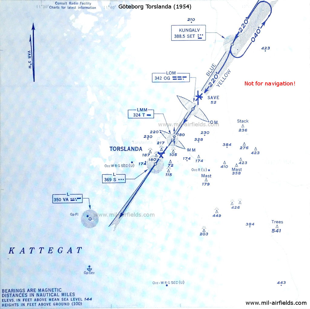
ILS approach to Göteborg Torslanda Airport in 1954 (Source: DoD)
Gotska Sandön: NDB
N5824 E01912 (approx.) Google Maps
GS, 395 kHz
N5824 E01912 (approx.) Google Maps
GS, 395 kHz
Operated 0300 to 1900 and on request.
For historical information only, do not use for navigation or aviation purposes!
Hallsberg: NDB
N5904 E01459 (approx.) Google Maps
SIR, 398 kHz
N5904 E01459 (approx.) Google Maps
SIR, 398 kHz
At the intersection of airway Green Three (G3) and Red Four (R4). Boundary between Göteborg FIR and Stockholm FIR.
Jönköping: Airfield
Jönköping: Locator
N5747 E01412 (approx.), 217°/0.73 NM to field Google Maps
R, 325 kHz
N5747 E01412 (approx.), 217°/0.73 NM to field Google Maps
R, 325 kHz
Located at Rocksjon. Operated on request.
Jönköping: Locator
N5750 E01417 (approx.), 217°/5.18 NM to field Google Maps
OJ, 354 kHz
N5750 E01417 (approx.), 217°/5.18 NM to field Google Maps
OJ, 354 kHz
Located at Gisebo. Operated on request.
Karlstadt: Jakobsberg Airfield (Karlstad-Jakobsberg flygplats)
Karlstad: Locator
N5921 E01328 (approx.), 359°/0.55 NM to field Google Maps
K, 345 kHz
N5921 E01328 (approx.), 359°/0.55 NM to field Google Maps
K, 345 kHz
Operated on request.
Kronobergshed: Airfield
Kronobergshed: Locator
N5659 E01434 (approx.), 187°/1.2 NM to field Google Maps
KR, 328 kHz
N5659 E01434 (approx.), 187°/1.2 NM to field Google Maps
KR, 328 kHz
(Alvesta). Operated on request to Malmö ACC.
Kungälv: NDB
N5750 E01157 (approx.), 217°/8.95 NM to Torslanda Google Maps
SET, 388.5 kHz
N5750 E01157 (approx.), 217°/8.95 NM to Torslanda Google Maps
SET, 388.5 kHz
On airway Red Four (R4).
For historical information only, do not use for navigation or aviation purposes!
Linköping: Saab Airfield (Tannefors)
Luleå: Kallax
Luleå Kallax: Locator
N6542 E02148 (approx.), 136°/12 NM to field Google Maps
LU, 338 kHz
N6542 E02148 (approx.), 136°/12 NM to field Google Maps
LU, 338 kHz
Operated on request.
Luleå Kallax: NDB
N6531 E02209 (approx.), 320°/1.68° to field Google Maps
SLU, 318 kHz
N6531 E02209 (approx.), 320°/1.68° to field Google Maps
SLU, 318 kHz
Operated on request. Northern end of airway Amber Eleven (A11).
Runway 14:
Luleå Kallax: ILS 14
LL, 110.3 MHz
LL, 110.3 MHz
To runway 14 (136°)
Luleå Kallax: LOM 14
N6536 E02200 (approx.), 136°/4.53 NM to field Google Maps
Locator: OL, 455 kHz
Outer Marker: Dashes, 75 MHz
N6536 E02200 (approx.), 136°/4.53 NM to field Google Maps
Locator: OL, 455 kHz
Outer Marker: Dashes, 75 MHz
Operated on request.
Luleå Kallax: LMM 14
N6533 E02206 (approx.), 136°/0.81 NM to field Google Maps
Locator: U, 306 kHz
Middle Marker: Dots Dashes, 75 MHz
N6533 E02206 (approx.), 136°/0.81 NM to field Google Maps
Locator: U, 306 kHz
Middle Marker: Dots Dashes, 75 MHz
Operated on request.
Malmö: Bulltofta Airport
Runway 06:
Malmö Bulltofta: LOM 06
N5534 E01258 (approx.), 060°/3.87 NM to field Google Maps
Locator: HY, 276 kHz
Outer Marker: Dashes, 75 MHz
N5534 E01258 (approx.), 060°/3.87 NM to field Google Maps
Locator: HY, 276 kHz
Outer Marker: Dashes, 75 MHz
On backbeam of the ILS 24. Operated on request.
Malmö Bulltofta: Locator
N5636 E01302 (approx.), 060°/0.77 NM to field Google Maps
S, 337 kHz
N5636 E01302 (approx.), 060°/0.77 NM to field Google Maps
S, 337 kHz
Operated on request.
Runway 24:
Malmö Bulltofta: ILS 24
BT, 109.5 MHz
BT, 109.5 MHz
To runway 24 (240°)
Malmö Bulltofta: LOM 24
N5539 E01311 (approx.), 240°/3.84 NM to field Google Maps
Locator: OT, 351 kHz
Outer Marker: Dashes, 75 MHz
N5539 E01311 (approx.), 240°/3.84 NM to field Google Maps
Locator: OT, 351 kHz
Outer Marker: Dashes, 75 MHz
Operated on request.
Malmö Bulltofta: MM 24
240°/0.77 NM to THR 24
Dots Dashes, 75 MHz
240°/0.77 NM to THR 24
Dots Dashes, 75 MHz
Malmö Bulltofta: Locator
N5537 E01306 (approx.), 240°/0.47 NM to field Google Maps
B, 337 kHz
N5537 E01306 (approx.), 240°/0.47 NM to field Google Maps
B, 337 kHz
Operated on request.
Malmö Bulltofta: IM 24
240°/0.17 NM to THR 24
Dots, 75 MHz
240°/0.17 NM to THR 24
Dots, 75 MHz
Norrfors: NDB
N6353 E02004 (approx.) Google Maps
SIO, 364 kHz
N6353 E02004 (approx.) Google Maps
SIO, 364 kHz
(Umeå). On airway Amber Eleven (A11). Operated from 0500 to 2200.
Norrköping: Kungsängen Airfield
Runway 27:
Norrköping: ILS 27
NK, 109.5 MHz
NK, 109.5 MHz
To runway 27 (270°)
Norrköping: LOM 27
N5835 E01623 (approx.), 272°/3.89 NM (or 4.4 NM?) to THR 27 Google Maps
Locator: ON, 324 kHz
Outer Marker: Dashes, 75 MHz
N5835 E01623 (approx.), 272°/3.89 NM (or 4.4 NM?) to THR 27 Google Maps
Locator: ON, 324 kHz
Outer Marker: Dashes, 75 MHz
Located at Konungsund. Operated on request.
Norrköping: LMM 27
N5835 E01617 (approx.), 272°/0.52 NM to THR 27 Google Maps
Locator: K, 377 kHz
Middle Marker: Dots Dashes, 75 MHz
N5835 E01617 (approx.), 272°/0.52 NM to THR 27 Google Maps
Locator: K, 377 kHz
Middle Marker: Dots Dashes, 75 MHz
Located at Dagsberg. Operated on request.
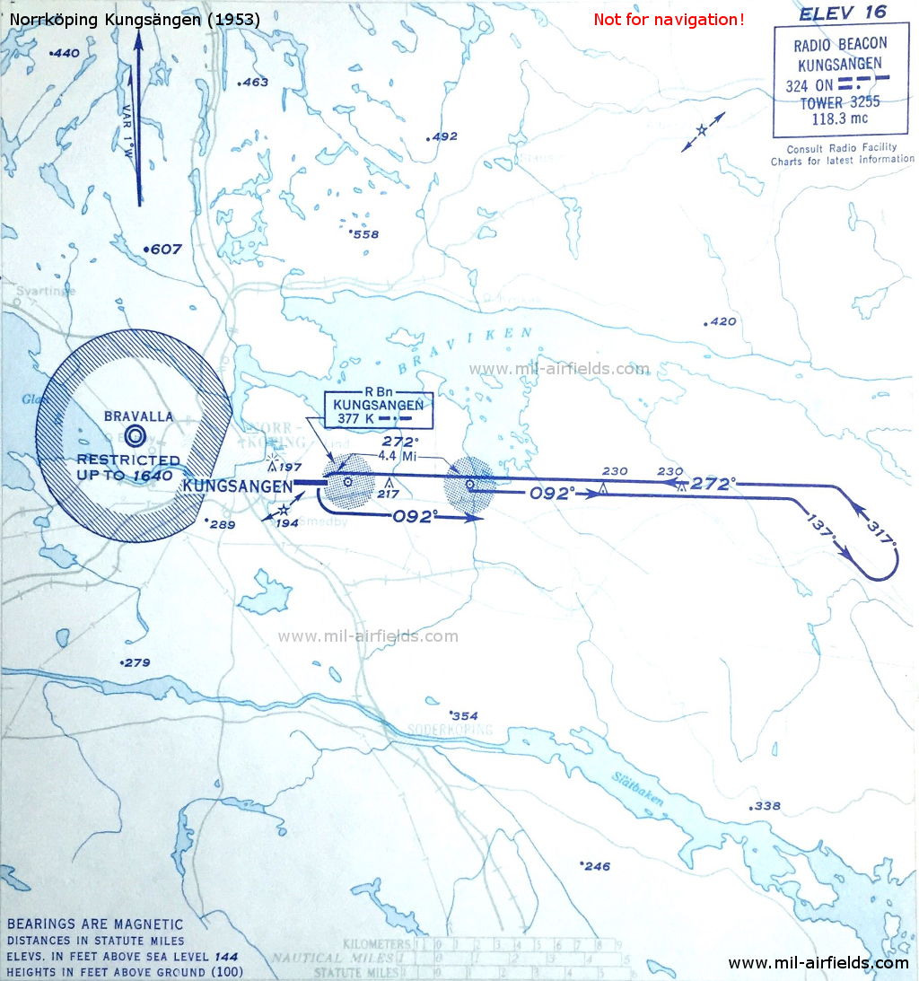
Approach to Norrköping Kungsängen in 1953 (Source: DoD)
Örebro: Gustavsvik Airfield (Örebro flygfält, Gustavsviksfältet)
Örebro: Locator
N5915 E01515 (approx.), 274°/0.65 NM to field Google Maps
A, 335 kHz
N5915 E01515 (approx.), 274°/0.65 NM to field Google Maps
A, 335 kHz
Operated on request.
For historical information only, do not use for navigation or aviation purposes!
Rinkaby: Airfield (Åhus)
Rinkaby: Locator
N5600 E01420 (approx.), 232°/1.14 NM to field Google Maps
RI, 363 kHz
N5600 E01420 (approx.), 232°/1.14 NM to field Google Maps
RI, 363 kHz
Operated on request.
Skellefteå: NDB
N6443 E02104 (approx.) Google Maps
SIK, 324 kHz
N6443 E02104 (approx.) Google Maps
SIK, 324 kHz
On airway Amber Eleven (A11). Operated from 0500 to 2200.
Stockholm: Bromma Airfield
Runway 13:
Stockholm Bromma: ILS 13
SO, 110.3 MHz
SO, 110.3 MHz
To runway 13 (125°)
Stockholm Bromma: Skalby Range
N592350 E0174910 (approx.), 125°/4.0 NM to THR 13 Google Maps
SK, 364 kHz
N592350 E0174910 (approx.), 125°/4.0 NM to THR 13 Google Maps
SK, 364 kHz
In the early 1950s, Skalby Range was at the location of the Outer Marker runway 13. The four predefined courses to the range were 026°, 125°, 206° and 305°. It has been later replaced by the locator "OS".
Stockholm Bromma: LOM 13
N5924 E01750 (approx.), 126°/3.54 NM to THR 13 Google Maps
Locator: OS, 364 kHz
Outer Marker: Dashes, 75 MHz
N5924 E01750 (approx.), 126°/3.54 NM to THR 13 Google Maps
Locator: OS, 364 kHz
Outer Marker: Dashes, 75 MHz
Located in Skälby, Järfälla.
Stockholm Bromma: LMM 13 (Flysta)
N5922 E01755 (approx.), 125°/0.55 NM to THR 13 Google Maps
Locator: B, 375 kHz
Middle Marker: Dots Dashes, 75 MHz
N5922 E01755 (approx.), 125°/0.55 NM to THR 13 Google Maps
Locator: B, 375 kHz
Middle Marker: Dots Dashes, 75 MHz
Sundby. Operated on request.
Stockholm Bromma: IM 13
125° to THR 13
Dots, 75 MHz
125° to THR 13
Dots, 75 MHz
Runway 31:
Stockholm Bromma: LOM 31 (Tanto)
N5919 E01803 (approx.), 305°/3.41 NM to field Google Maps
Locator: TA, 322 kHz
N5919 E01803 (approx.), 305°/3.41 NM to field Google Maps
Locator: TA, 322 kHz
Södermalm. On back course of ILS 13.
Stockholm Bromma: LMM 31
N5921 E01759 (approx.), 305°/0.75 NM to THR 31 Google Maps
Locator: U, 344 kHz
Middle Marker: Dots Dashes, 75 MHz
N5921 E01759 (approx.), 305°/0.75 NM to THR 31 Google Maps
Locator: U, 344 kHz
Middle Marker: Dots Dashes, 75 MHz
On back course of ILS 13.
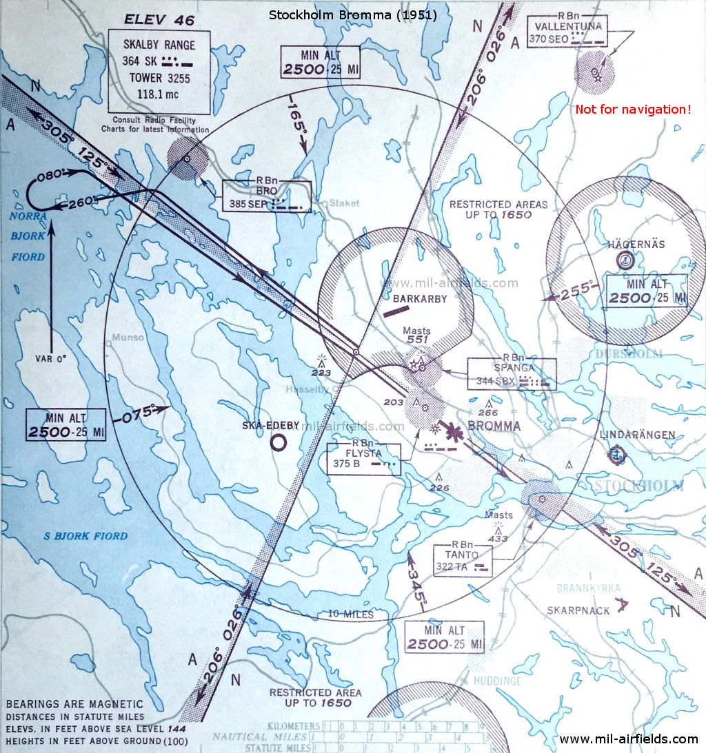
Range approach to Stockholm Bromma Airport in 1951 (Source: DoD)
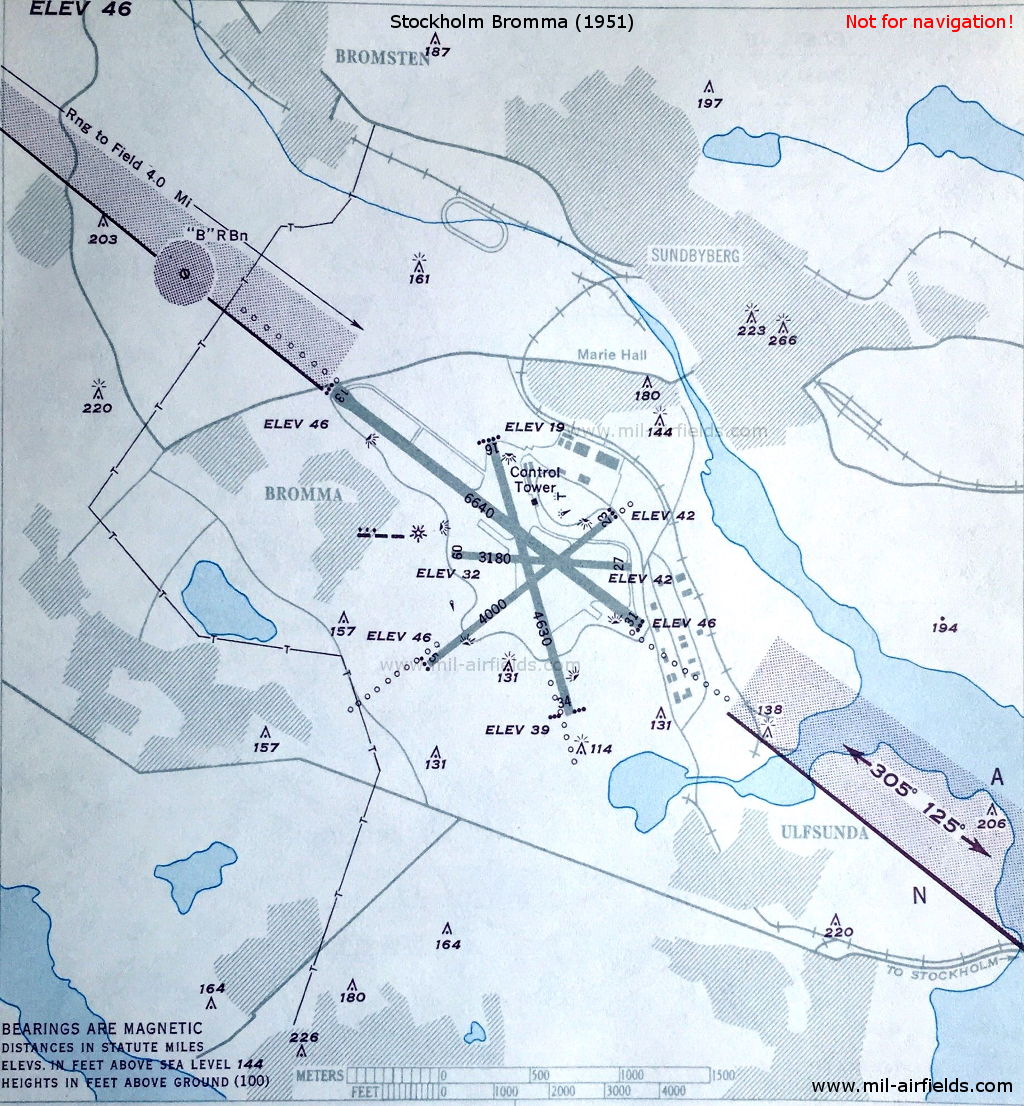
Stockholm Bromma Airport in 1951 - The Flysta "B" NDB is located at the beginning of the approach lights to runway 13 in the west. The course 305° to Skalby "SK" Range 4 miles away leads across the airfield. (Source: DoD)
For historical information only, do not use for navigation or aviation purposes!
Sundsvall: Timrå Airport (Sundsvall–Härnösand flygplats)
Sundsvall Härnösand: Locator
N6231 E01727 (approx.), 341°/0.46 NM to field Google Maps
S, 350 kHz
N6231 E01727 (approx.), 341°/0.46 NM to field Google Maps
S, 350 kHz
Operated on request.
Sundsvall Härnösand: NDB
N6228 E01729 (approx.), 347°/4.07 NM to field Google Maps
SEN, 388 kHz
N6228 E01729 (approx.), 347°/4.07 NM to field Google Maps
SEN, 388 kHz
Located at Alnön. On airway Amber Eleven (A11). Operated from 0500 to 2200.
Trummen: NDB
N5919 E01328 (approx.), 359°/2.46 NM to Karlstad Jakobsberg Google Maps
SEM, 323 kHz
N5919 E01328 (approx.), 359°/2.46 NM to Karlstad Jakobsberg Google Maps
SEM, 323 kHz
On airway Green Three (G3).
Ugglarp: NDB
N5528 E01317 (approx.), 320°/10.8 NM to Malmö Bulltofta Google Maps
UG, 358 kHz, low power
N5528 E01317 (approx.), 320°/10.8 NM to Malmö Bulltofta Google Maps
UG, 358 kHz, low power
Uppsala: Airfield (Ärna Flygplats)
Uppsala Ärna: Locator
N5952 E01724 (approx.), 076°/5.4 NM to field Google Maps
LP, 438 kHz
N5952 E01724 (approx.), 076°/5.4 NM to field Google Maps
LP, 438 kHz
Operated from 0700 to 1600.
Uppsala Ärna: NDB
N5955 E01735 (approx.), 360°/0.49 NM to field Google Maps
SLP, 438 kHz
N5955 E01735 (approx.), 360°/0.49 NM to field Google Maps
SLP, 438 kHz
Located near Vänge.
Vagnhärad: NDB
N5857 E01730 (approx.) Google Maps
SIV, 358 kHz
N5857 E01730 (approx.) Google Maps
SIV, 358 kHz
At the intersection of airway Blue Seven (B7) and Red One (R1).
For historical information only, do not use for navigation or aviation purposes!
Vallentuna: NDB
N5933 E01806 (approx.), 203°/12.4 NM to Bromma Google Maps
SEO, 370 kHz
N5933 E01806 (approx.), 203°/12.4 NM to Bromma Google Maps
SEO, 370 kHz
At the intersection of airway Amber Eleven (A11) and Red One (R1).
Västerljung: VOR
N5855 E01727 (approx.), 217°/2.32 NM to Vagnharad NDB Google Maps
VJ, 112.7 MHz
N5855 E01727 (approx.), 217°/2.32 NM to Vagnharad NDB Google Maps
VJ, 112.7 MHz
On test.
Vinga: NDB
N5738 E01136 (approx.), 053°/7.0 NM to Torslanda Google Maps
VA, 350 kHz
N5738 E01136 (approx.), 053°/7.0 NM to Torslanda Google Maps
VA, 350 kHz
Located on Vinga island, west of Göteborg.
Visby: Airfield
Visby: NDB
N5736 E01823 (approx.), 339°/3.7 NM to field Google Maps
VL, 364 kHz
N5736 E01823 (approx.), 339°/3.7 NM to field Google Maps
VL, 364 kHz
End of airway Blue Seven (B7). Operated on request.
Runway 21:
Visby: ILS 21
VB, 110.3 MHz
VB, 110.3 MHz
To runway 21 (207°). Operated on request.
Visby: LOM 21
N5743 E01824 (approx.), 207°/4.0 NM to THR 21 Google Maps
Locator: OV, 343 kHz
Outer Marker: Dots Dashes, 75 MHz
N5743 E01824 (approx.), 207°/4.0 NM to THR 21 Google Maps
Locator: OV, 343 kHz
Outer Marker: Dots Dashes, 75 MHz
Operated on request.
Visby: LMM 21
N5740 E01821 (approx.), 207°/0.62 NM to THR 21 Google Maps
Locator: B, 379 kHz
Middle Marker: Dots Dashes, 75 MHz
N5740 E01821 (approx.), 207°/0.62 NM to THR 21 Google Maps
Locator: B, 379 kHz
Middle Marker: Dots Dashes, 75 MHz
Operated on request.
For historical information only, do not use for navigation or aviation purposes!
Maps
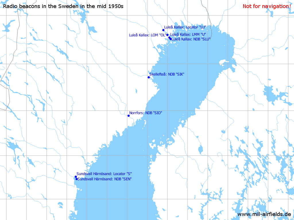
Not all labels are shown
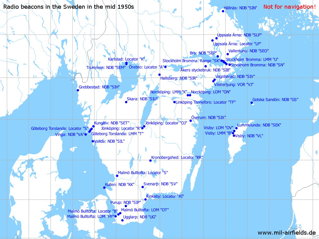
Not all labels are shown
Recommended
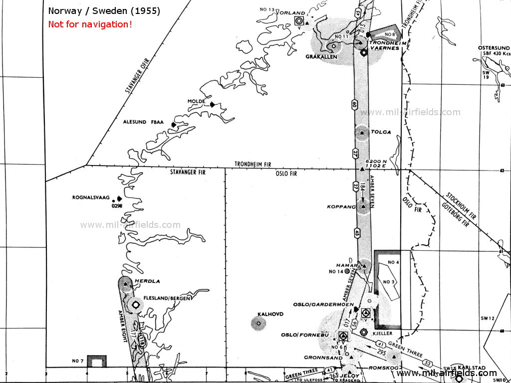
Image credits are shown on the respective target page, click on the preview to open it.