Radio navigation in Spain in the 1950s
Radiofaros en España en los años 50: NDB, Range, ILS
For historical information only, do not use for navigation or aviation purposes!
The following list contains the aeronautical radio beacons that were active in Spain in the mid of the 1950s. All information is outdated and may not be used for navigational purposes.
At this time there were only non-directional beacons (NDB) and Ranges. The airports of Barcelona and Madrid were equipped with a Standard Beam Approach (SBA) system. Madrid also had an Instrument Landing System (ILS). It is noteworthy that in Spain there were two Consol radio beacons, the successor of the German Sonne system.
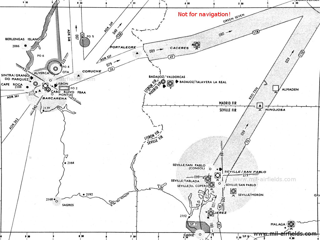
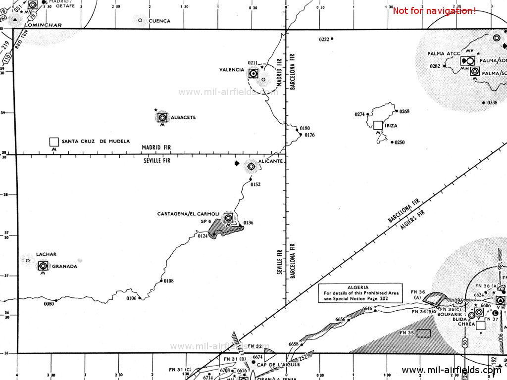
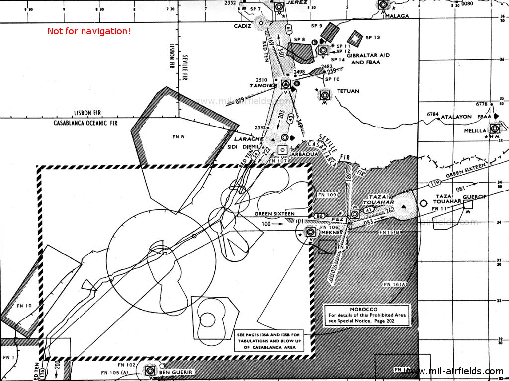
Radio beacons and airways in 1955
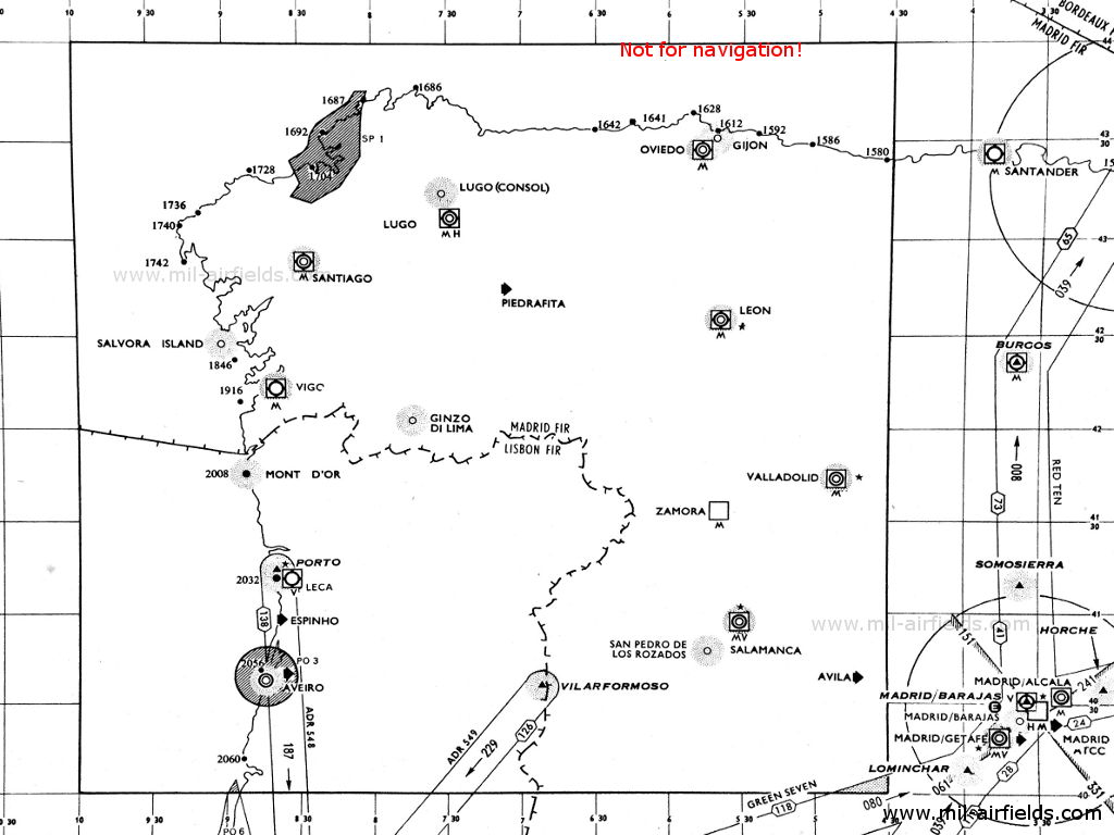
1 (Source: DoD)
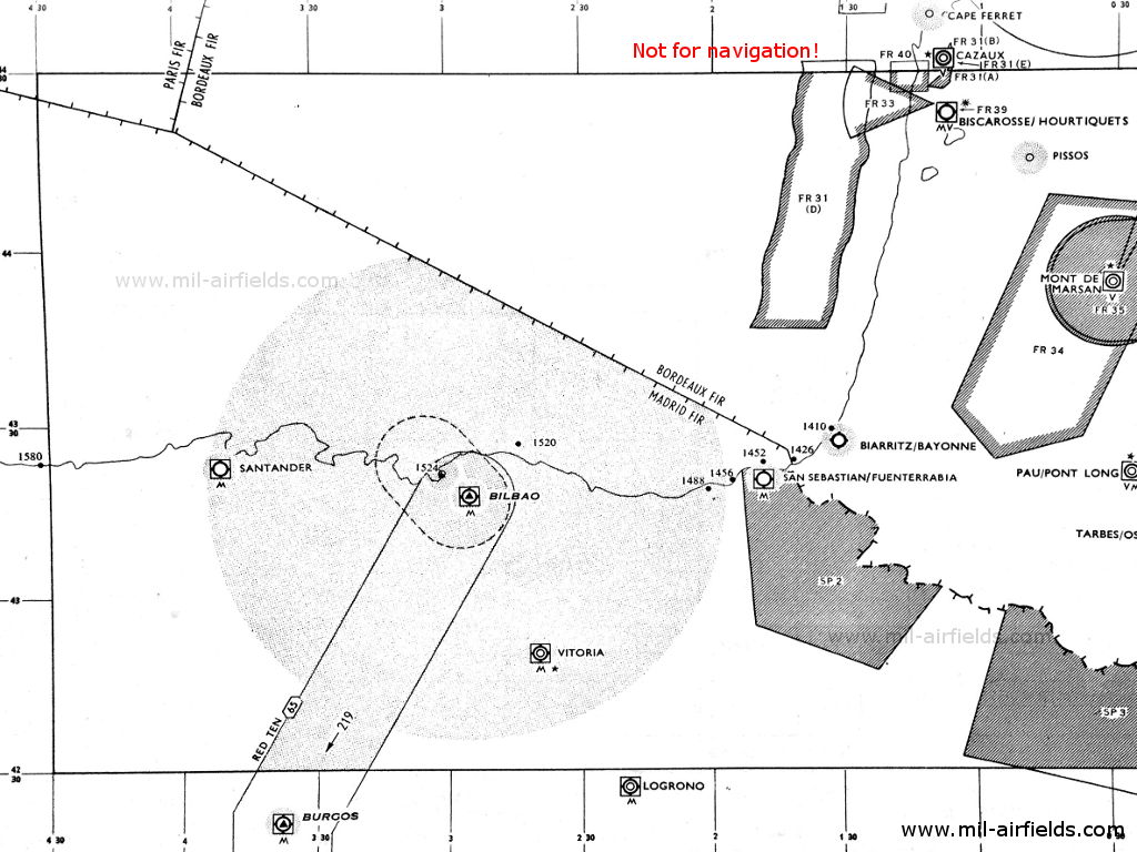
2 (Source: DoD)
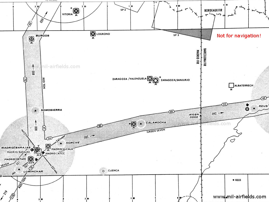
3 (Source: DoD)
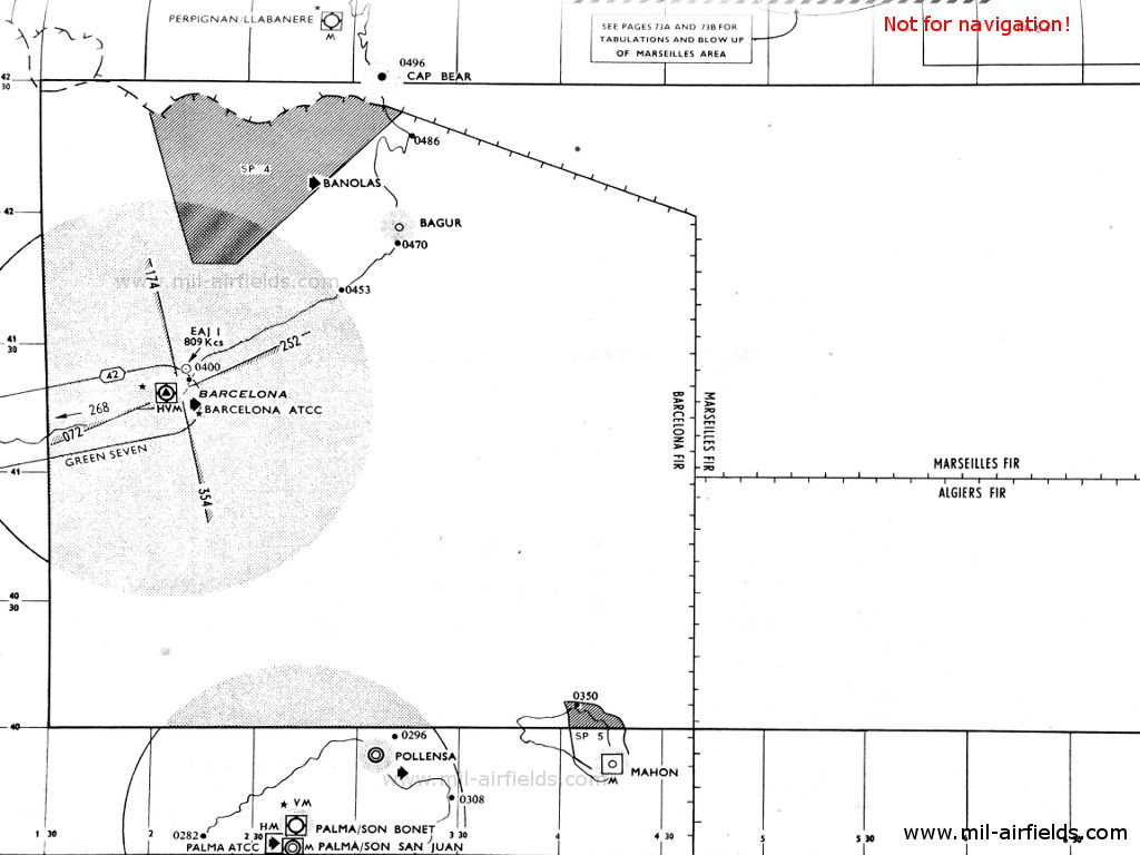
4 (Source: DoD)
5 (Source: DoD)
6 (Source: DoD)
7 (Source: DoD)
8 (Source: DoD)
Explanations
![]()
Abbreviations
| approx. | approximately | |
| civ | civil | civil operator |
| GP | Glide path | Glide path transmitter |
| ILS | Instrument Landing System | (Approach and landing aid) |
| IM | Inner Marker | Marker beacon just in front the runway |
| kHz | Kilohertz | (Unit for frequency) |
| L | Locator | Non-directional beacon for the approach |
| LLZ | Localizer | Localizer transmitter |
| LMM | Locator Middle Marker | Combination of Middle Marker and Locator |
| LOM | Locator Outer Marker | Combination of Outer Marker and Locator |
| m | Meter | (Unit for length) |
| MHz | Megahertz | (Unit for frequency) |
| mil | military | military operator |
| MM | Middle Marker | Marker beacon |
| NDB | Non-directional beacon | Non-directional beacon on long or medium waves |
| NM | Nautical Miles | (Unit for length) |
| OM | Outer Marker | Marker beacon |
| PRMG | ПРМГ Посадочная радиомаячная группа | Soviet / russian military instrument landing system |
| RSBN | РСБН Rадиотехническая система ближней навигации | Soviet / russian military radio navigation system |
| SBA | Standard Beam Approach | Approach system, Lorenz system, predecessor of the ILS |
| THR | Threshold | Runway threshold (most often with number of runway) |
| transf. | transformed | Coordinates were converted from a different reference system, therefore there may be deviations. |
| VAR | Visual-Aural Rnange | |
| VOR | VHF Omnidirectional Radio Range | |
| W | Watt | (Unit for power) |
| WGS84 | World Geodetic System 1984 | (geospatial reference system, GPS coordinates) |
Directory
For historical information only, do not use for navigation or aviation purposes!
Albacete: Air Base (Los Llanos Air Base)
Albacete: Locator (mil)
100°/0.56 NM to field
L, 350 kHz
100°/0.56 NM to field
L, 350 kHz
Operated on request.
Alicante: Rabasa Airfield
Badajoz: Talavera la Real Air Base (Aeropuerto de Badajoz)
Badajoz/Talavera la Real: Locator (mil)
N3853 W00649 (approx.), 310°/0.54 NM to field Google Maps
TR, 370 kHz
N3853 W00649 (approx.), 310°/0.54 NM to field Google Maps
TR, 370 kHz
Operated on request.
Badajoz/Talavera la Real: NDB (mil)
BZ, 298 kHz, 300 W
BZ, 298 kHz, 300 W
Operated on request.
Barcelona: Airport (Muntadas, Aeroport de Barcelona, Aeropuerto de Barcelona-El Prat)
Runway 25R:
Barcelona: Range
N4119 E00208 (approx.), 253°/2.43 NM to field Google Maps
QUU, 262 kHz
N4119 E00208 (approx.), 253°/2.43 NM to field Google Maps
QUU, 262 kHz
The four predefined courses to the Range were 073°, 174°, 253° and 354°.
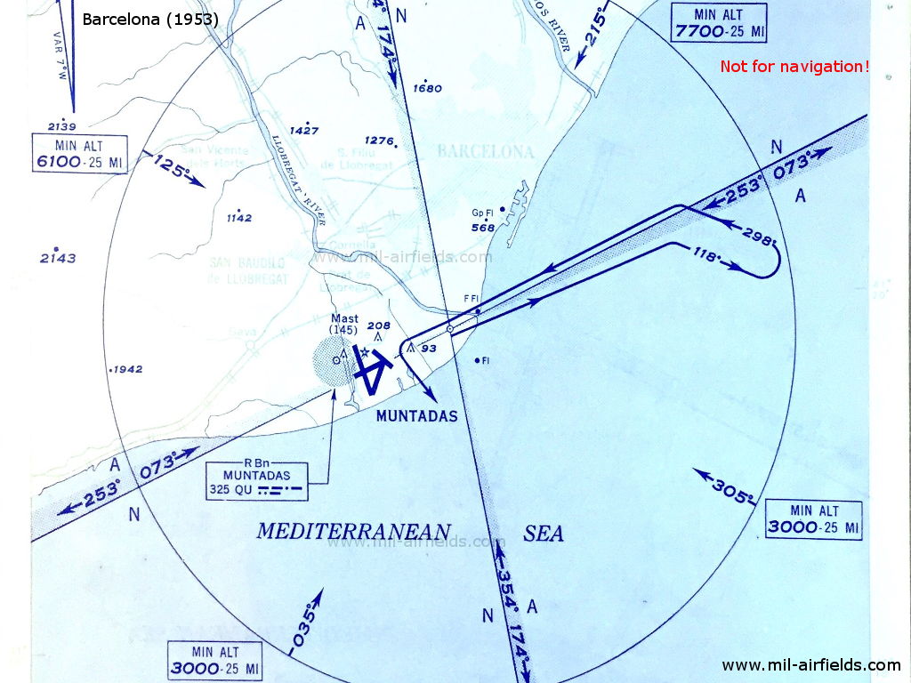
Range Approach to Barcelona in 1953 - The Range is located northeast of the field. The map shows the four courses and the A/N sectors. (Source: DoD)
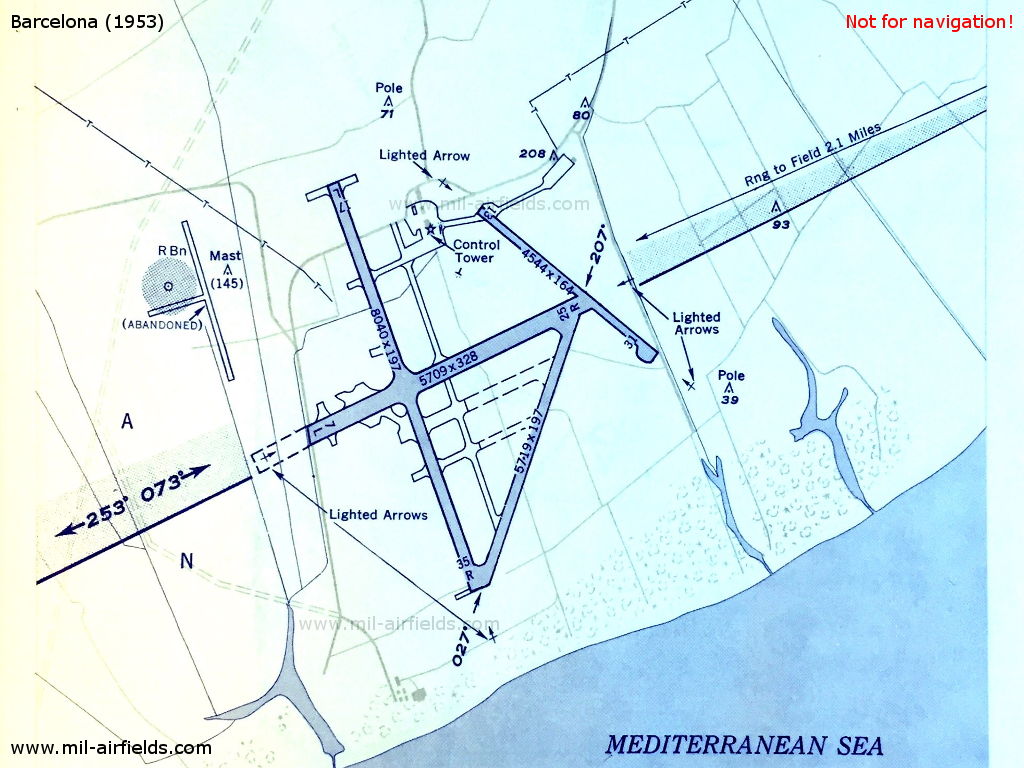
Barcelona Airport in 1953 - The QU radio beacon was located in the northwestern part of the airfield, next to some abandoned taxiways. (Source: DoD)
Bilbao: Airport (Aeropuerto de Bilbao)
For historical information only, do not use for navigation or aviation purposes!
Burgos
Cáceres: Airfield
Calamocha: Airfield
Cuenca: NDB
CU, 295 kHz, 200 W
CU, 295 kHz, 200 W
Operated from 0700 to 1300 and from 1630 to 0100.
El Carmoli: Airfield
El Carmolí: NDB (mil)
185°/1.0 NM to field
LC, 381 kHz, 200 W
185°/1.0 NM to field
LC, 381 kHz, 200 W
Operated on request.
For historical information only, do not use for navigation or aviation purposes!
Granada: Airfield (Base Aérea de Armilla)
Jerez de la Frontera: Airport (Aeropuerto de La Parra, Aeropuerto de Jerez)
Láchar: NDB
N3712 W00351 (approx.) Google Maps
LA, 250 kHz, 300 W
N3712 W00351 (approx.) Google Maps
LA, 250 kHz, 300 W
Operated Tuesdays, Thursdays and Sundays from 0910 to 1135.
Las Palmas: Airport
Las Palmas: Locator
P, 365 kHz
P, 365 kHz
For historical information only, do not use for navigation or aviation purposes!
León: Airfield (Aeropuerto de León, Aeródromo Militar de León)
León: NDB (mil/civ)
LN, 265 kHz, 200 W
LN, 265 kHz, 200 W
Operated on request.
Lugo: Consol
N4315 W00729 (approx.) Google Maps
LG, 285 kHz, 1500 W
N4315 W00729 (approx.) Google Maps
LG, 285 kHz, 1500 W
120 seconds keying cycle. 60 seconds continuous Dot/Dashes.
Madrid: Barajas Airport (Aeropuerto Adolfo Suárez Madrid-Barajas)
Runway 33:
Madrid/Barajas: ILS 33
MDY, 109.9 MHz
MDY, 109.9 MHz
Madrid/Barajas: Range/OM 33 (ILS)
N4025 W00330 (approx.), 331°/3.6 NM to THR33 Google Maps
Range: MDD, 278 kHz
Outer Marker: Dashes, 75 MHz
N4025 W00330 (approx.), 331°/3.6 NM to THR33 Google Maps
Range: MDD, 278 kHz
Outer Marker: Dashes, 75 MHz
Madrid/Barajas: LMM 33 (ILS)
331°/0.53 NM to THR 33
Locator: MY, 390 kHz, 50 W
Middle Marker: Dots Dashes, 75 MHz
331°/0.53 NM to THR 33
Locator: MY, 390 kHz, 50 W
Middle Marker: Dots Dashes, 75 MHz
Madrid/Barajas: SBA 33
33.3 MHz
33.3 MHz
Madrid/Barajas: OM 33 (SBA)
331°/1.62 NM to THR 33
Dashes, 38 MHz
331°/1.62 NM to THR 33
Dashes, 38 MHz
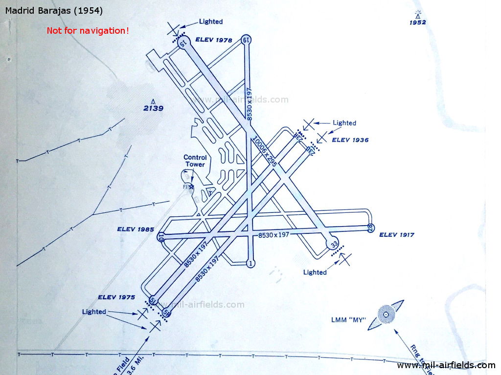
Madrid Barajas Airport in 1954 (Source: DoD)
Getafe: Air Base (Base Aérea de Getafe)
Madrid/Getafe: NDB (SAF/USAF)
050°/0.6 NM to field
G, 367 kHz, 50 W
050°/0.6 NM to field
G, 367 kHz, 50 W
Operated on 45 minutes request to Tower.
San Luis: Airfield (Aeródromo de San Luis, Mahón)
Malaga: Airport
Malaga: Locator (mil/civ)
N3639 W00428 (approx.), 315°/0.43 NM to field Google Maps
R, 383 kHz, 50 W
N3639 W00428 (approx.), 315°/0.43 NM to field Google Maps
R, 383 kHz, 50 W
Operated on request.
For historical information only, do not use for navigation or aviation purposes!
Morón: Air Base (Base Aérea de Morón de la Frontera)
La Morgal: Airfield
Palma de Mallorca: Son Bonet Airfield
Palma: Locator (civ)
N3934 E00239 (approx.), 060°/2.16 NM to field Google Maps
EDI1, 363 kHz
N3934 E00239 (approx.), 060°/2.16 NM to field Google Maps
EDI1, 363 kHz
Operated on request.
Pollensa
Pollensa: NDB (mil)
PO, 280 kHz, 300 W
PO, 280 kHz, 300 W
Operated from sunrise to sunset.
Reus: Airfield
Salamanca: Matacán Air Base (Base Aérea de Matacán)
Sálvora: NDB
N4228 W00901 (approx.) Google Maps
RA, 318 kHz
N4228 W00901 (approx.) Google Maps
RA, 318 kHz
Isla de Sálvora. Operated in clear weather H+04, 34; in fog H+04 and every 6 minutes.
For historical information only, do not use for navigation or aviation purposes!
San Pedro de Rozados: NDB
JW, 255 kHz, 1500 W
JW, 255 kHz, 1500 W
Operated from 0730 to 1830 and on request to Salamanca.
San Sebastián: Airport (Aeropuerto de San Sebastián)
San Sebastián/Fuenterrabía: Locator
N4321 W00148 (approx.), 190°/1.66 NM to field Google Maps
H, 380 kHz
N4321 W00148 (approx.), 190°/1.66 NM to field Google Maps
H, 380 kHz
Hondarribia.
Santander: Airport (Aeropuerto de Santander-Seve Ballesteros)
Santiago de Compostela: Airport
Santiago: Locator (mil/civ)
S, 370 kHz
S, 370 kHz
Operated on request.
Santiago: NDB (mil/civ)
N4253 W00825 (approx.) Google Maps
ST, 270 kHz, 200 W
N4253 W00825 (approx.) Google Maps
ST, 270 kHz, 200 W
Santiago de Compostela. Operated from 0800 to 1900.
Sevilla/San Pablo: Consol
N3731 W00602 (approx.) Google Maps
SL, 315 kHz
N3731 W00602 (approx.) Google Maps
SL, 315 kHz
Operated from 0600 to 2300 and on request to Seville/San Pablo direction finder. 60 seconds keying cycle, 120 seconds cont. note.
Sevilla: San Pablo Airport
Sevilla/San Pablo: Locator
279°/0.56 NM to field
S, 383 kHz
279°/0.56 NM to field
S, 383 kHz
Operated on request during VFR, continuously during IFR.
Sevilla/San Pablo: NDB (civ)
N3719 W00553 (approx.), 009°/5.8 NM to field Google Maps
HT, 369 kHz, 200 W
N3719 W00553 (approx.), 009°/5.8 NM to field Google Maps
HT, 369 kHz, 200 W
Operated from 2300 to 0600 and on request from 0600 to 2300.
Sevilla/San Pablo: Range
N3725 W00548 (approx.), 279°/3.67 NM to field Google Maps
SPP, 260 kHz
N3725 W00548 (approx.), 279°/3.67 NM to field Google Maps
SPP, 260 kHz
Operated on request during VFR, continuously during IFR.
San Cristóbal de La Laguna: Tenerife North Airport (Aeropuerto de Tenerife Norte, Aeropuerto de Los Rodeos)
For historical information only, do not use for navigation or aviation purposes!
Valencia: Airport
Valencia: Locator
B, 400 kHz, 50 W
B, 400 kHz, 50 W
Valencia: NDB
N3926 W00019 (approx.), 290°/7.0 NM to field Google Maps
VC, 340 kHz
N3926 W00019 (approx.), 290°/7.0 NM to field Google Maps
VC, 340 kHz
Operated from 0630 to 0800 and from 1300 to 2200.
Valencia: NDB
N3925 W00020 (approx.), 296°/6.5 NM to field Google Maps
VC, 340 kHz, 300 W
N3925 W00020 (approx.), 296°/6.5 NM to field Google Maps
VC, 340 kHz, 300 W
Operated from 0800 to 1300. On test.
Valladolid: Airfield (Villanubla)
Vigo: Airport (Aeropuerto de Vigo)
Vigo: NDB (civ)
N4210 W00838 (approx.), 013°/3.5 NM to field Google Maps
VG, 250 kHz, 300 W
N4210 W00838 (approx.), 013°/3.5 NM to field Google Maps
VG, 250 kHz, 300 W
Operated on request.
Vitoria: Salburua Airport (Aeródromo de Salburua)
Zaragoza: Sanjurjo Airfield
Zaragoza/Sanjurjo: Locator
310°/0.57 NM to field
Z, 345 kHz
310°/0.57 NM to field
Z, 345 kHz
Operated on request.
For historical information only, do not use for navigation or aviation purposes!