Radio beacons in Greece in the 1950s
Ελλάδα, Ellada
For historical information only, do not use for navigation or aviation purposes!
The following list contains the aeronautical radio beacons that were active in Greece in the mid of the 1950s. All information is outdated and may not be used for navigational purposes.
Attention: Taking pictures at military airfields in Greece is prohibited and will be severely punished. According to reports on the Internet, the local population also diligently reports suspicious persons.
Radio beacons and airways in 1955
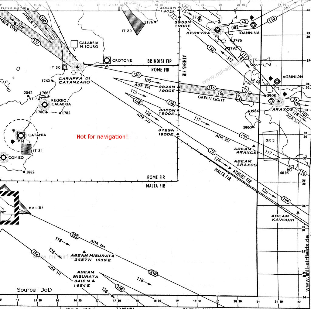
Kerkyra Corfu, Araxos (Source: DoD)
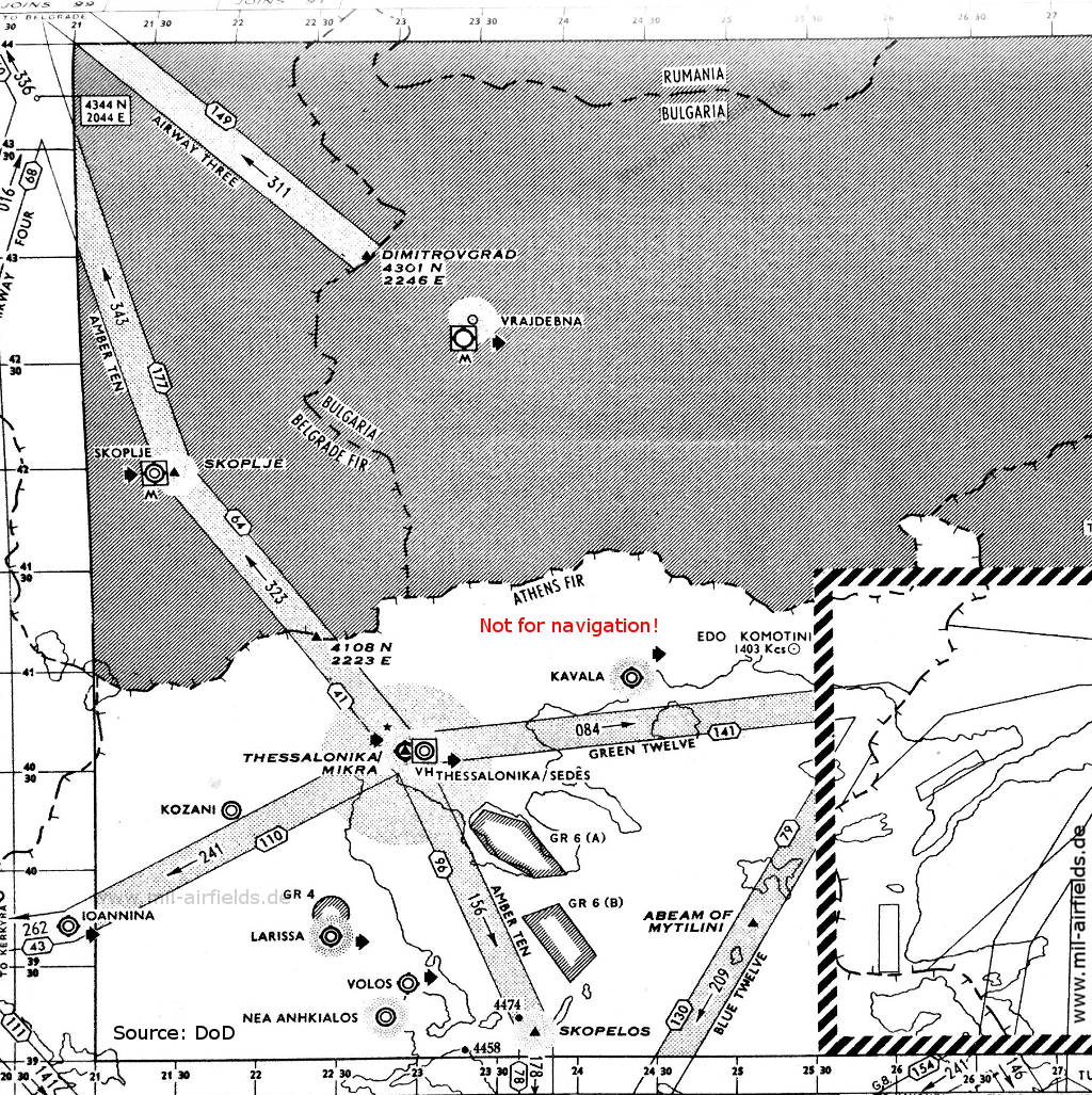
Thessaloniki, Kavala (Source: DoD)
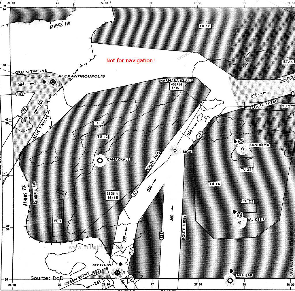
Alexandroupolis, Mytilini (Source: DoD)
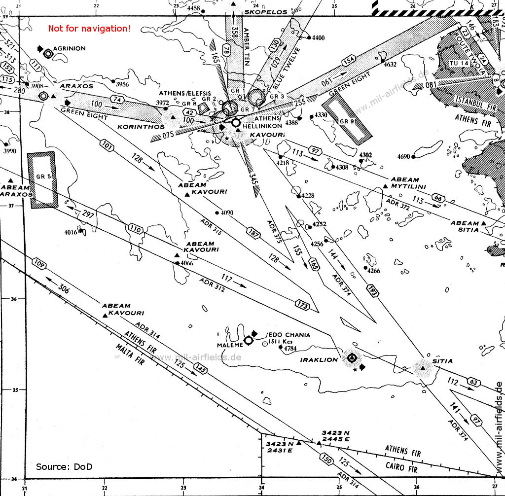
Athens, Iraklio Crete (Source: DoD)
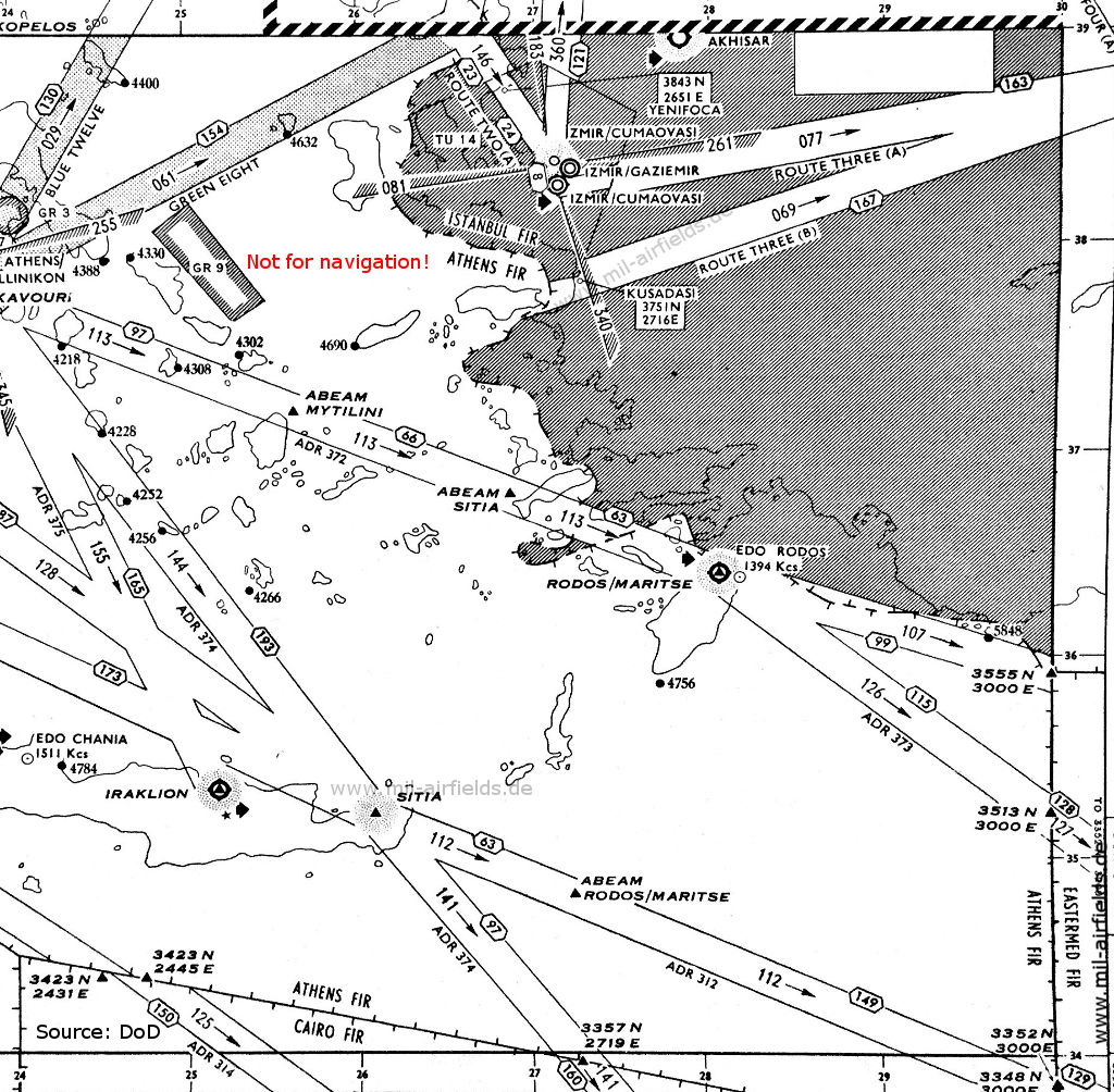
Iraklion, Rhodes, South Aegean (Source: DoD)
Explanations
![]()
Abbreviations
| approx. | approximately | |
| civ | civil | civil operator |
| GP | Glide path | Glide path transmitter |
| ILS | Instrument Landing System | (Approach and landing aid) |
| IM | Inner Marker | Marker beacon just in front the runway |
| kHz | Kilohertz | (Unit for frequency) |
| L | Locator | Non-directional beacon for the approach |
| LLZ | Localizer | Localizer transmitter |
| LMM | Locator Middle Marker | Combination of Middle Marker and Locator |
| LOM | Locator Outer Marker | Combination of Outer Marker and Locator |
| m | Meter | (Unit for length) |
| MHz | Megahertz | (Unit for frequency) |
| mil | military | military operator |
| MM | Middle Marker | Marker beacon |
| NDB | Non-directional beacon | Non-directional beacon on long or medium waves |
| NM | Nautical Miles | (Unit for length) |
| OM | Outer Marker | Marker beacon |
| PRMG | ПРМГ Посадочная радиомаячная группа | Soviet / russian military instrument landing system |
| RSBN | РСБН Rадиотехническая система ближней навигации | Soviet / russian military radio navigation system |
| SBA | Standard Beam Approach | Approach system, Lorenz system, predecessor of the ILS |
| THR | Threshold | Runway threshold (most often with number of runway) |
| transf. | transformed | Coordinates were converted from a different reference system, therefore there may be deviations. |
| VAR | Visual-Aural Rnange | |
| VOR | VHF Omnidirectional Radio Range | |
| W | Watt | (Unit for power) |
| WGS84 | World Geodetic System 1984 | (geospatial reference system, GPS coordinates) |
Directory
For historical information only, do not use for navigation or aviation purposes!
Alexandroupoli (Κρατικός Αερολιμένας Αλεξανδρούπολης "Δημόκριτος", Kratikós Aeroliménas Alexandroúpolis "Dimókritos")
Alexandroupolis / Αλεξανδρούπολη: NDB
N4051 E02557 (approx.), 160°/0.2 NM to field Google Maps
SWD, 351 kHz
N4051 E02557 (approx.), 160°/0.2 NM to field Google Maps
SWD, 351 kHz
Araxos: Air Base (Κρατικός Αερολιμένας Αράξου, Kratikos Aerolimenas Araxou, Patras Araxos Airport)
Araxos / Άραξος: NDB
N3810 E02126 (approx.), 197°/1.3 NM to field Google Maps
SWX, 326 kHz
N3810 E02126 (approx.), 197°/1.3 NM to field Google Maps
SWX, 326 kHz
Operated from 0500 to 1900.
Athens: Ellinikon Airport (Hellenikon Air Base, Αθήνα, Κρατικός Αερολιμένας Αθηνών)
Athens Ellinikon / Ελληνικόν: NDB
N3752 E02345 (approx.), 330°/1.9 NM to field Google Maps
HN, 372 kHz, 1500 W
N3752 E02345 (approx.), 330°/1.9 NM to field Google Maps
HN, 372 kHz, 1500 W
Athens Ellinikon / Ελληνικόν: Range/Z-Marker
N3756 E02343 (approx.), 161°/2.3 NM to field Google Maps
HK, 319, 100 W
N3756 E02343 (approx.), 161°/2.3 NM to field Google Maps
HK, 319, 100 W
Elefsis (Αεροπορική Βάση Ελευσίνας)
Heraklion: Airport (Κρατικός Αερολιμένας Ηρακλείου "Νίκος Καζαντζάκης", Kratikos Aerolimenas "Nikos Kazantzakis")
Kavala: Amygdaleónas (Καβάλα Αμυγδαλεώνας)
Kavala / Καβάλα: NDB
N4058 E02421 (approx.) Google Maps
SWB, 327 kHz, 190 W
N4058 E02421 (approx.) Google Maps
SWB, 327 kHz, 190 W
No specific working hours.
For historical information only, do not use for navigation or aviation purposes!
Corfu: Airport (Kerkyra, Κέρκυρα, Αερολιμένας Ιωάννης Καποδίστριας)
Korinthos / Κόρινθος: NDB
N3756 E02256 (approx.) Google Maps
PD, 392 kHz, 190 W
N3756 E02256 (approx.) Google Maps
PD, 392 kHz, 190 W
Operated continuously, except from 1130 to 1230.
Larisa (Λάρισα, Λάρισσα, Larissa)
Larissa / Λάρισσα: NDB
N3939 E02226 (approx.), 080°/1.8 NM to field Google Maps
SWL, 365 kHz, 300 W
N3939 E02226 (approx.), 080°/1.8 NM to field Google Maps
SWL, 365 kHz, 300 W
Operated from 0400 to 1800.
Mytilini: Airfield (Κρατικός Αερολιμένας Μυτιλήνης, Οδυσσέας Ελύτης)
Nea Anchialos: Airfield (Κρατικός Αερολιμένας Νέας Αγχιάλου, Kratikos Aerolimenas Neas Anchialou)
Rhodes: Maritsa Air Base
For historical information only, do not use for navigation or aviation purposes!
Sitia / Σητεία: NDB
N3512 E02606 (approx.) Google Maps
ZO, 309 kHz, 100 W
N3512 E02606 (approx.) Google Maps
ZO, 309 kHz, 100 W
Crete, Lasithi (Κρήτη / Kriti, Λασίθι)
Skopelos / Σκόπελος: NDB
N3907 E02344 (approx.) Google Maps
SC, 315.3 kHz, 190 W
N3907 E02344 (approx.) Google Maps
SC, 315.3 kHz, 190 W
Operated from sunrise to sunset according to airline traffic requirements.
Thessaloniki: Mikra Airport (Κρατικός Αερολιμένας Θεσσαλονίκης "Μακεδονία", Mikra Air Base)
Sedes: Air Base (Αεροδρόμιο Σέδες)
Thessaloniki Sedes / Σέδες: NDB
N4030 E02302 (approx.) Google Maps
SD, 407 kHz, 70 W
N4030 E02302 (approx.) Google Maps
SD, 407 kHz, 70 W
Operated from 0500 to 1700.
For historical information only, do not use for navigation or aviation purposes!
Recommended
Image credits are shown on the respective target page, click on the preview to open it.