Historical radio beacons in Yugoslavia in the 1950s
For historical information only, do not use for navigation or aviation purposes!
The following list contains the aeronautical radio beacons that were active in Yugoslavia in the mid of the 1950s. The list is likely to be incomplete, as there is no information on military radio beacons. All information is outdated and may not be used for navigational purposes.
At this time predominantly Non-Directional Beacons (NDB) were used. At Belgrade-Zemun airport, however, there was already a VOR in operation.
Explanations
![]()
Abbreviations
| approx. | approximately | |
| civ | civil | civil operator |
| GP | Glide path | Glide path transmitter |
| ILS | Instrument Landing System | (Approach and landing aid) |
| IM | Inner Marker | Marker beacon just in front the runway |
| kHz | Kilohertz | (Unit for frequency) |
| L | Locator | Non-directional beacon for the approach |
| LLZ | Localizer | Localizer transmitter |
| LMM | Locator Middle Marker | Combination of Middle Marker and Locator |
| LOM | Locator Outer Marker | Combination of Outer Marker and Locator |
| m | Meter | (Unit for length) |
| MHz | Megahertz | (Unit for frequency) |
| mil | military | military operator |
| MM | Middle Marker | Marker beacon |
| NDB | Non-directional beacon | Non-directional beacon on long or medium waves |
| NM | Nautical Miles | (Unit for length) |
| OM | Outer Marker | Marker beacon |
| PRMG | ПРМГ Посадочная радиомаячная группа | Soviet / russian military instrument landing system |
| RSBN | РСБН Rадиотехническая система ближней навигации | Soviet / russian military radio navigation system |
| SBA | Standard Beam Approach | Approach system, Lorenz system, predecessor of the ILS |
| THR | Threshold | Runway threshold (most often with number of runway) |
| transf. | transformed | Coordinates were converted from a different reference system, therefore there may be deviations. |
| VAR | Visual-Aural Rnange | |
| VOR | VHF Omnidirectional Radio Range | |
| W | Watt | (Unit for power) |
| WGS84 | World Geodetic System 1984 | (geospatial reference system, GPS coordinates) |
Directory
For historical information only, do not use for navigation or aviation purposes!
Belgrade: Zemun Airport (Beograd, Аеродром Београд Земун)
Belgrade-Zemun Airport was located in the former People's Republic of Serbia (Narodna Republika Srbija / Народна Република Србија). Today, the airport is closed, the area belongs the municipality "Novi Beograd" (Нови Београд).
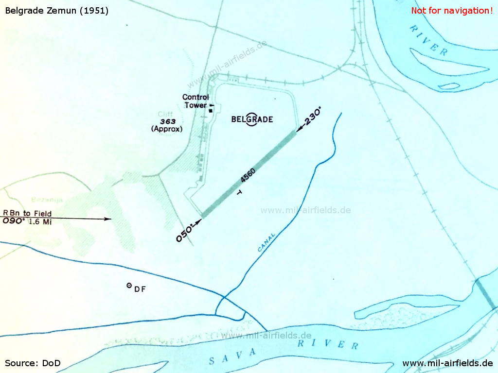
Belgrade Zemun Airport, Yugoslavia, 1953 (Source: DoD)
Bled/Lesce: NDB
N4621 E01411 (approx.) Google Maps
LC, 390 kHz, 100 W
N4621 E01411 (approx.) Google Maps
LC, 390 kHz, 100 W
People's Republic of Slovenia (Ljudska republika Slovenija / Socijalistička Republika Slovenija / Социјалистичка Република Словенија)
Ivanicgrad: NDB
N4542 E01629 (approx.) Google Maps
IG, 316 kHz, 500 W
N4542 E01629 (approx.) Google Maps
IG, 316 kHz, 500 W
Operated on request.
Approx. 6 km east of Ivanić-Grad.
People's Republic of Croatia (Narodna Republika Hrvatska / Народна Република Хрватск).
Pula: NDB
N4453 E01353 (approx.) Google Maps
PL, 420 kHz
N4453 E01353 (approx.) Google Maps
PL, 420 kHz
People's Republic of Croatia (Narodna Republika Hrvatska / Народна Република Хрватск).
Sarajevo: Butmir Airport (Međunarodni aerodrom Sarajevo)
Sarajevo/Butmir: NDB
N4353 E01818 (approx.) Google Maps
SE, 405 kHz, 100 W
N4353 E01818 (approx.) Google Maps
SE, 405 kHz, 100 W
Operated on request.
People's Republic of Bosnia and Herzegovina (Narodna Republika Bosna i Hercegovina / Народна Република Босна и Херцеговина)
Skopje: (old Aerodrom)
Skopje was located in the former People's Republic of Macedonia (Народна Република Македонија). The old airport was located about 3 km southeast of the city center in today's district "Aerodrom".
Skoplje: NDB
N4159 E02132 (approx.), 270/2.5 NM to field Google Maps
SQ, 370 kHz, 1200 W
N4159 E02132 (approx.), 270/2.5 NM to field Google Maps
SQ, 370 kHz, 1200 W
Operated Monday-Friday 0800-1300, 1600-2200, Tuesday 0000-1830, Wednesday 2300-0200, 0700-2130, Thursday 0730-2000, Friday 0000-0300, 1030-2000, Saturday 0800-2200, Sunday 0830-1800.
For historical information only, do not use for navigation or aviation purposes!
Slavonski-Brod: NDB
N4510 E01801 (approx.) Google Maps
SB, 340.5 kHz, 200 W
N4510 E01801 (approx.) Google Maps
SB, 340.5 kHz, 200 W
People's Republic of Croatia (Narodna Republika Hrvatska / Народна Република Хрватск).
Zagreb: Airfield Lučko (Zračno pristanište Lučko)
Zagreb/Lucko: NDB
N4546 E01553 (approx.) Google Maps
LU, 399 kHz, 100 W
N4546 E01553 (approx.) Google Maps
LU, 399 kHz, 100 W
Operated on request.
People's Republic of Croatia (Narodna Republika Hrvatska / Народна Република Хрватск).
Zagreb/Lucko: NDB
N4547 E01550 (approx.) Google Maps
ZR, 367 kHz, 800 W
N4547 E01550 (approx.) Google Maps
ZR, 367 kHz, 800 W
People's Republic of Croatia (Narodna Republika Hrvatska / Народна Република Хрватск).
For historical information only, do not use for navigation or aviation purposes!
Recommended


Image credits are shown on the respective target page, click on the preview to open it.