Radio beacons in the Republic of Ireland in the 1950s
NDB, Range, ILS
For historical information only, do not use for navigation or aviation purposes!
The following list contains the aeronautical radio beacons that were active in the Republic of Ireland in the mid of the 1950s. This compilation is probably incomplete. All information is outdated and may not be used for navigational purposes.
At this time there were mainly non-directional beacons (NDB). But at Shannon Airport, which was of great importance for North Atlantic air traffic, a VOR was already in test operation. The airports of Dublin and Shannon were equipped with Instrument Landing Systems (ILS).
Radio beacons and airways
Radio beacons Ireland (Source: DoD)
Explanations
![]()
Abbreviations
| approx. | approximately | |
| civ | civil | civil operator |
| GP | Glide path | Glide path transmitter |
| ILS | Instrument Landing System | (Approach and landing aid) |
| IM | Inner Marker | Marker beacon just in front the runway |
| kHz | Kilohertz | (Unit for frequency) |
| L | Locator | Non-directional beacon for the approach |
| LLZ | Localizer | Localizer transmitter |
| LMM | Locator Middle Marker | Combination of Middle Marker and Locator |
| LOM | Locator Outer Marker | Combination of Outer Marker and Locator |
| m | Meter | (Unit for length) |
| MHz | Megahertz | (Unit for frequency) |
| mil | military | military operator |
| MM | Middle Marker | Marker beacon |
| NDB | Non-directional beacon | Non-directional beacon on long or medium waves |
| NM | Nautical Miles | (Unit for length) |
| OM | Outer Marker | Marker beacon |
| PRMG | ПРМГ Посадочная радиомаячная группа | Soviet / russian military instrument landing system |
| RSBN | РСБН Rадиотехническая система ближней навигации | Soviet / russian military radio navigation system |
| SBA | Standard Beam Approach | Approach system, Lorenz system, predecessor of the ILS |
| THR | Threshold | Runway threshold (most often with number of runway) |
| transf. | transformed | Coordinates were converted from a different reference system, therefore there may be deviations. |
| VAR | Visual-Aural Rnange | |
| VOR | VHF Omnidirectional Radio Range | |
| W | Watt | (Unit for power) |
| WGS84 | World Geodetic System 1984 | (geospatial reference system, GPS coordinates) |
Directory
For historical information only, do not use for navigation or aviation purposes!
Dublin: Airport (Aerfort Bhaile Átha Cliath, Collinstown)
Runway 24:
Dublin: Rush NDB
N5331 W00607 (approx.), 238°/6.5 NM to THR 24 Google Maps
DW, 326 kHz, 30 W
N5331 W00607 (approx.), 238°/6.5 NM to THR 24 Google Maps
DW, 326 kHz, 30 W
(Ros Eó, An Ros)
Dublin: ILS 24
DW, 110.3 MHz
DW, 110.3 MHz
Operated at aerodrome times.
Dublin: LOM 24
238°/3.74 NM to THR 24
Locator: OD, 343 kHz
Outer Marker: Dashes, 75 MHz
238°/3.74 NM to THR 24
Locator: OD, 343 kHz
Outer Marker: Dashes, 75 MHz
Dublin: LMM 24
238°/0.67 NM to THR 24
Locator: C, 362 kHz
Outer Marker: Dot Dash, 75 MHz
238°/0.67 NM to THR 24
Locator: C, 362 kHz
Outer Marker: Dot Dash, 75 MHz
Dublin: IM 24
Dots, 75 MHz
Dots, 75 MHz
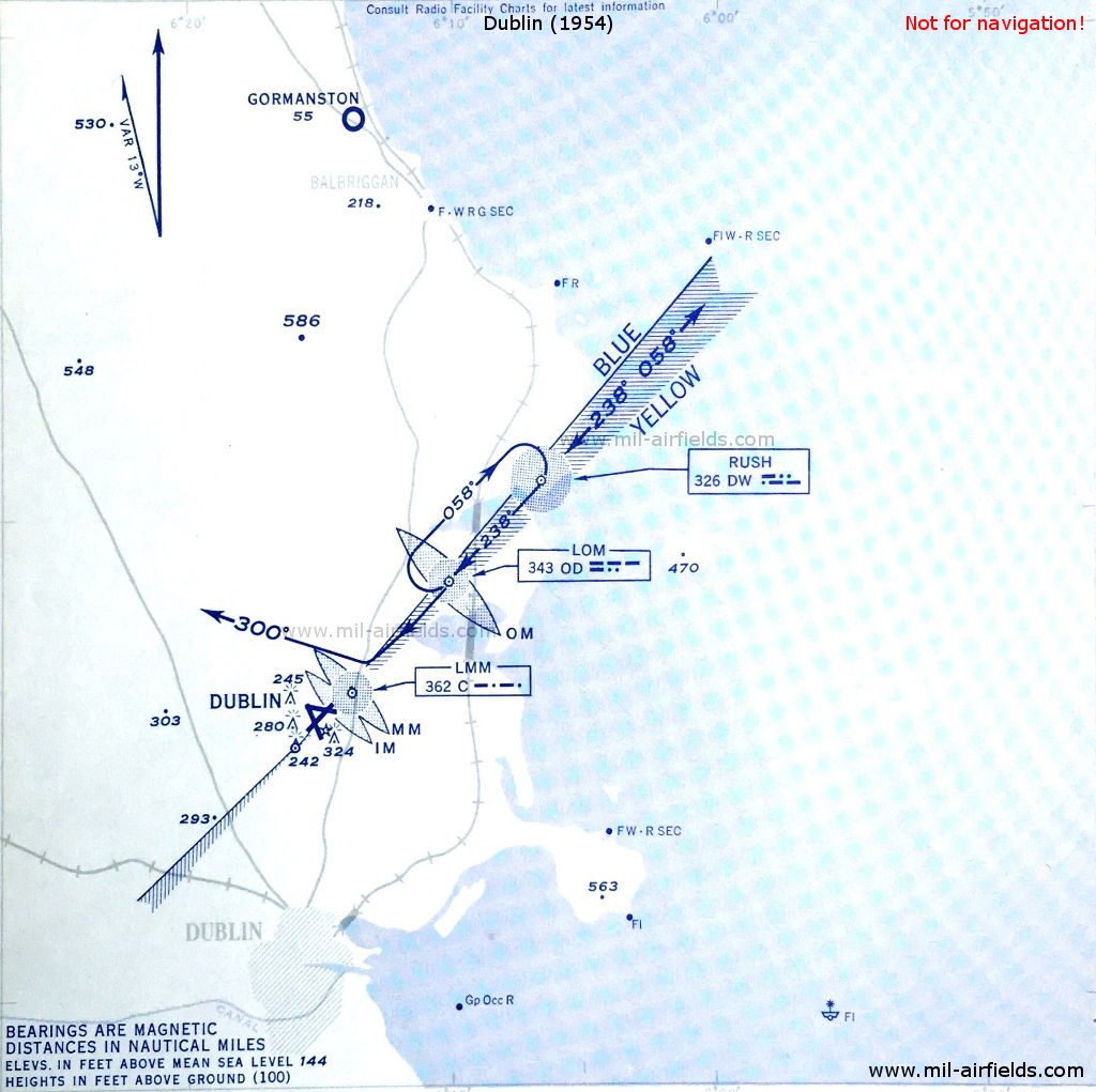
ILS approach to Dublin in 1954 - There are three Non-Directional Beacons "DW", "OD" and "C" on the approach course. (Source: DoD)
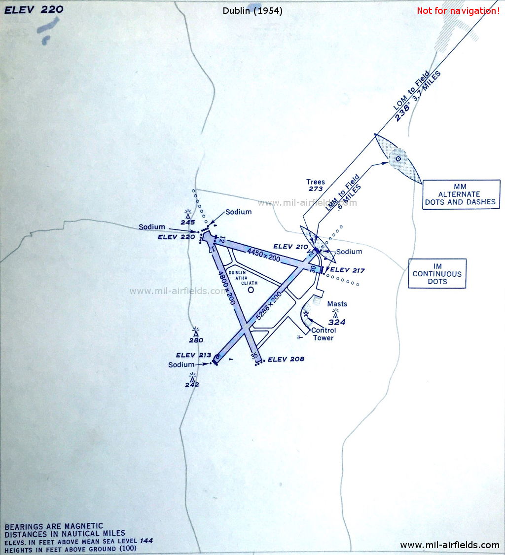
Dublin Airport in 1954 - The Middle Marker (MM) is located 0.6 nautical miles from the field, the Inner Marker (IM) is located directly at the beginning of runway 24. (Source: DoD)
Shannon: Airport (Aerfort na Sionna, Limerick)
Shannon: Range/Z Marker
N5242 W00849 (approx.), 284°/3.5 NM to field Google Maps
Range: SA, 352 kHz, 75 W
Z Marker: 75 MHz
N5242 W00849 (approx.), 284°/3.5 NM to field Google Maps
Range: SA, 352 kHz, 75 W
Z Marker: 75 MHz
Was located near Bunratty. The four predefined courses to the Range were: 014°, 104°, 209° and 307°.
Runway 23:
Shannon: NDB
N5250 W00845 (approx.), 229°/9.3 NM to field Google Maps
EJT, 387 kHz, 25 W
N5250 W00845 (approx.), 229°/9.3 NM to field Google Maps
EJT, 387 kHz, 25 W
Was located north of Lough Cullaunyheeda, near Tyrera.
Shannon: ILS 23
SA, 110.3 MHz
SA, 110.3 MHz
To runway 23 (229°)
Shannon: LOM 23
N5246 W00851 (approx.), 229°/3.82 NM to THR 23 Google Maps
Locator: OL, 339 kHz
Outer Marker: Dashes, 75 MHz
N5246 W00851 (approx.), 229°/3.82 NM to THR 23 Google Maps
Locator: OL, 339 kHz
Outer Marker: Dashes, 75 MHz
Was located southwest of Fenloe Lake.
Shannon: LMM 23
N5243 W00854 (approx.), 229°/0.56 NM to THR 23 Google Maps
Locator: S, 316 kHz
Middle Marker: Dot-Dash, 75 MHz
N5243 W00854 (approx.), 229°/0.56 NM to THR 23 Google Maps
Locator: S, 316 kHz
Middle Marker: Dot-Dash, 75 MHz
Shannon: IM 23
Dots, 75 MHz
Dots, 75 MHz
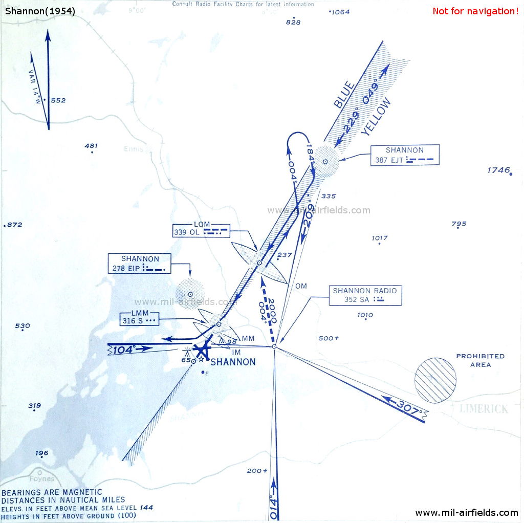
ILS approach to Shannon, 1954 - On the approach course for runway 23, which is closed today, there are three non-directional radio beacons (NDB) "EJT", "OL" and "S". (Source: DoD)
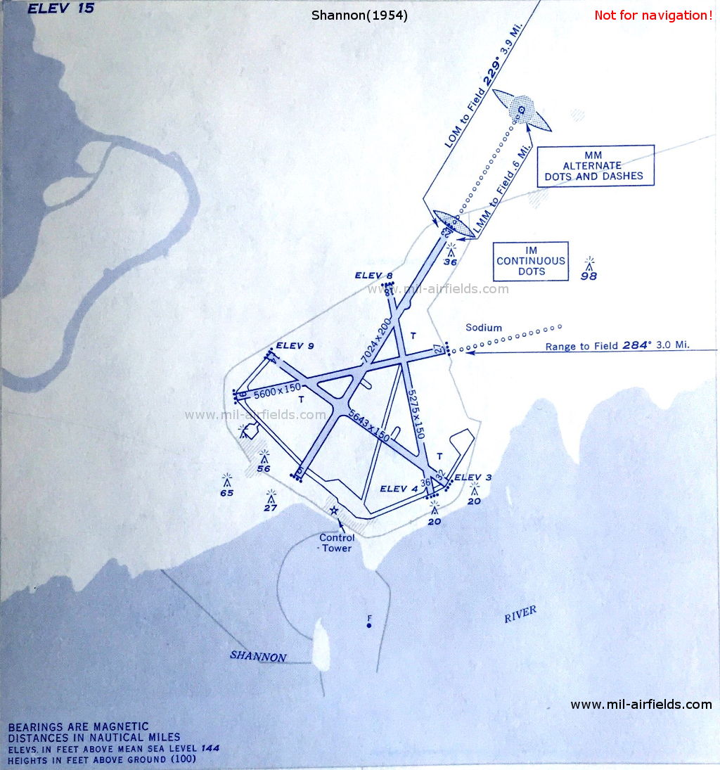
Shannon Airport, 1954 - The Middle Marker (MM) is at the beginning of the approach lighting, the Inner Marker (IM) directly at the beginning of runway 23. (Source: DoD)
For historical information only, do not use for navigation or aviation purposes!
Tuskar Rock Lighthouse: NDB
N5212 W00612 (approx.) Google Maps
TR, 296.5 kHz
N5212 W00612 (approx.) Google Maps
TR, 296.5 kHz
Operated H+00 and every 6 minutes.
Island in the St George’s Channel
For historical information only, do not use for navigation or aviation purposes!
Maps
Not all labels are shown
Recommended


Image credits are shown on the respective target page, click on the preview to open it.