Radio beacons in Luxembourg in the 1950s
Lëtzebuerg
For historical information only, do not use for navigation or aviation purposes!
The following list contains the aeronautical radio beacons that were active in the Grand Duchy of Luxembourg in the mid of the 1950s. All information is outdated and may not be used for navigational purposes.
Radio beacons and airways in 1955
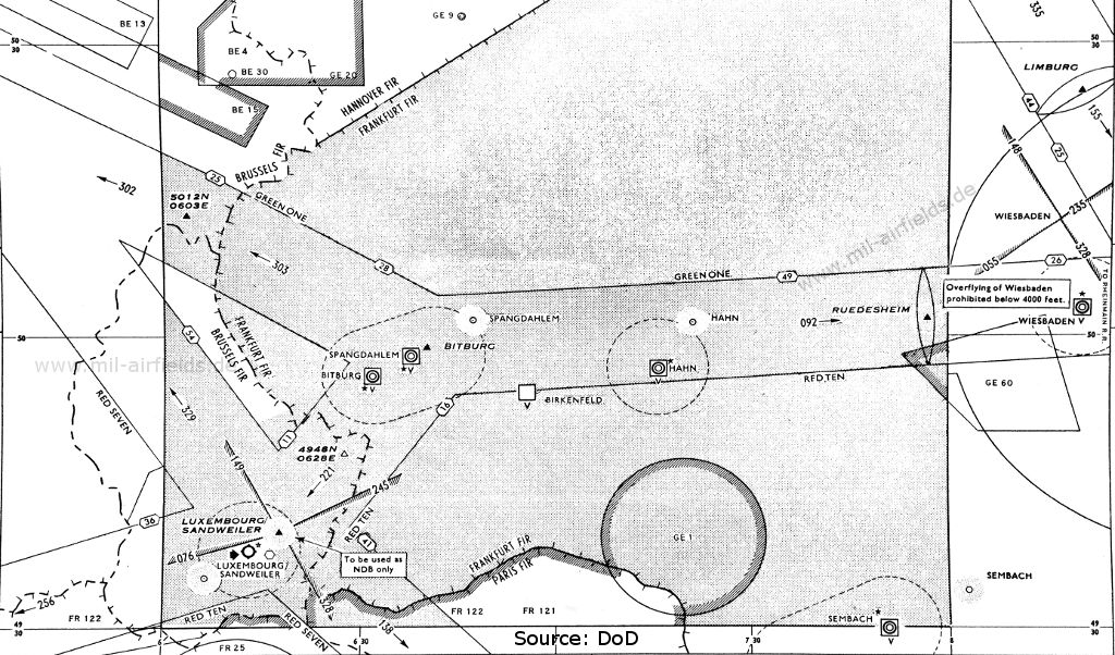
Map 1955 (Source: DoD)
Explanations
![]()
Abbreviations
| approx. | approximately | |
| civ | civil | civil operator |
| GP | Glide path | Glide path transmitter |
| ILS | Instrument Landing System | (Approach and landing aid) |
| IM | Inner Marker | Marker beacon just in front the runway |
| kHz | Kilohertz | (Unit for frequency) |
| L | Locator | Non-directional beacon for the approach |
| LLZ | Localizer | Localizer transmitter |
| LMM | Locator Middle Marker | Combination of Middle Marker and Locator |
| LOM | Locator Outer Marker | Combination of Outer Marker and Locator |
| m | Meter | (Unit for length) |
| MHz | Megahertz | (Unit for frequency) |
| mil | military | military operator |
| MM | Middle Marker | Marker beacon |
| NDB | Non-directional beacon | Non-directional beacon on long or medium waves |
| NM | Nautical Miles | (Unit for length) |
| OM | Outer Marker | Marker beacon |
| PRMG | ПРМГ Посадочная радиомаячная группа | Soviet / russian military instrument landing system |
| RSBN | РСБН Rадиотехническая система ближней навигации | Soviet / russian military radio navigation system |
| SBA | Standard Beam Approach | Approach system, Lorenz system, predecessor of the ILS |
| THR | Threshold | Runway threshold (most often with number of runway) |
| transf. | transformed | Coordinates were converted from a different reference system, therefore there may be deviations. |
| VAR | Visual-Aural Rnange | |
| VOR | VHF Omnidirectional Radio Range | |
| W | Watt | (Unit for power) |
| WGS84 | World Geodetic System 1984 | (geospatial reference system, GPS coordinates) |
Directory
For historical information only, do not use for navigation or aviation purposes!
Luxemburg: Findel Airport (Sandweiler)
Luxemburg/Sandweiler: VOR
LX, 114.4 MHz, 200 W
LX, 114.4 MHz, 200 W
Runway 07:
Luxemburg/Sandweiler: Locator
N4935 E00606 (approx.), 065°/3.95 NM to THR 07 Google Maps
LB, 346 kHz
N4935 E00606 (approx.), 065°/3.95 NM to THR 07 Google Maps
LB, 346 kHz
Previous frequency 344 kHz (1953). Operated in Instrument meteorological conditions (IMC) and on request.
Runway 25:
Luxemburg/Sandweiler: ILS 25
LX, 110.3 MHz
LX, 110.3 MHz
Operated in Instrument meteorological conditions (IMC) and on request.
Luxemburg/Sandweiler: Range/OM 25
N4939 E00618 (approx.), 245/3.83 NM to THR 25 Google Maps
Range: LXL, 368.5 kHz
Outer Marker: 75 MHz
N4939 E00618 (approx.), 245/3.83 NM to THR 25 Google Maps
Range: LXL, 368.5 kHz
Outer Marker: 75 MHz
In the mid-1950s, the Range was only to be used as NDB anymore.
Luxemburg/Sandweiler: LMM 25
N4937 E00612 (approx.), 245°/0.56 NM to THR 25 Google Maps
Locator: LA, 318 kHz
Middle Marker: Dots Dashes, 75 MHz
N4937 E00612 (approx.), 245°/0.56 NM to THR 25 Google Maps
Locator: LA, 318 kHz
Middle Marker: Dots Dashes, 75 MHz
Originally, the locator "LA" was located southwest of the field, with 065°/0.56 Nautical Miles to threshold runway 25. Operated in Instrument meteorological conditions (IMC) and on request.
Luxemburg/Sandweiler: IM 25
245° to THR 25
Dots, 75 MHz
245° to THR 25
Dots, 75 MHz
For historical information only, do not use for navigation or aviation purposes!
Recommended

Image credits are shown on the respective target page, click on the preview to open it.