Aeronautical Radio Beacons West Germany 1958/59

Radio beacons Federal Republic of Germany in 1958/59

Navaids: NDB, Range, ILS

For historical information only, do not use for navigation or aviation purposes!

The following list contains the aeronautical radio beacons that were active in the Federal Republic of Germany in 1958/59. All information is outdated and may not be used for navigational purposes.

At that time, civil route navigation was still mainly based on Non-Directional Beacons (NDBs) and some Ranges. However, various VORs have already been put into operation, some of which are still in test operation, such as Dortmund VOR. The ident of the enroute radio beacons still starts with a "D", e.g. Augsburg DIJ, Bartelsdorf DHO. This principle is given up in the following years, the beacons receive then identifications, which are based on the place names.

Each airport has a runway equipped with an instrument landing system.

In the military aviation, the Luftwaffe air bases and the airfields of the French and Canadians have Non-Directional Beacons (NDB). The US Air Force also uses NDBs, but in Hahn and Spangdahlem temporary VORs have been installed and in Giebelstadt, Hahn and Spangdahlem the first TACAN systems have been put to service. At bases of the Royal Air Force (RAF), in addition to NDBs, the typical RAF systems Eureka and BABS are also available.

Special features:

  • Independent Eureka radio beacon in Brekendorf, probably operated by the RAF. Possibly a replacement for Schleswig after this site was handed over to the German Navy.
  • Racon in Erding. Although the airfield has already been handed over to the German Air Force, the Racon could still be operated by the US Air Force.

Title image: Lufthansa Convair CV-440 D-ACEX and CV-340 D-ACEF. Source: ETH-Bibliothek Zürich, Bildarchiv / Fotograf: Furrer, Bernhard / SIK_02-07-0113, License: CC BY-SA 4.0

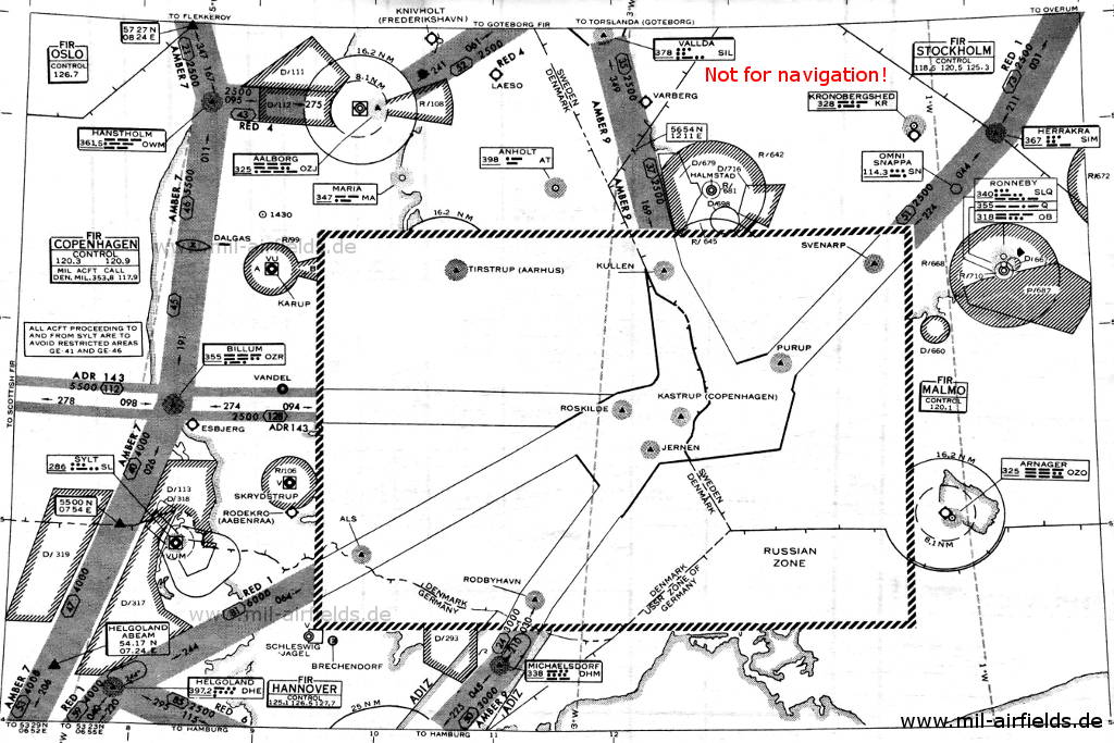
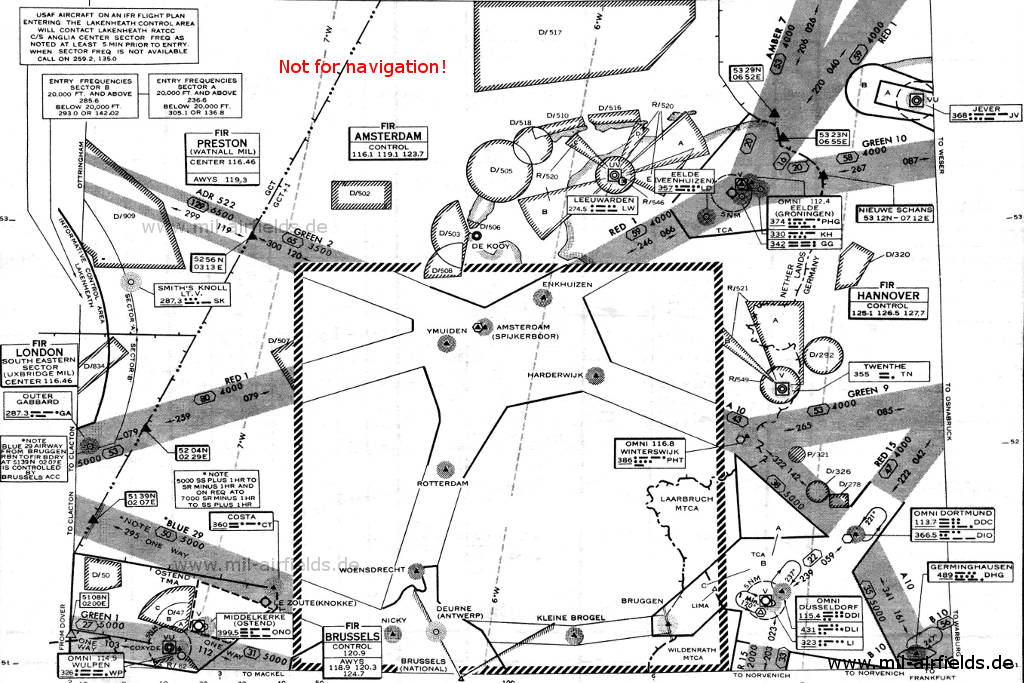
Radio beacons and airways in 1959
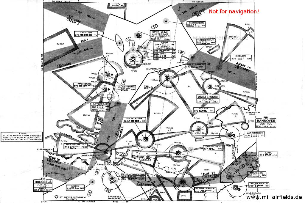
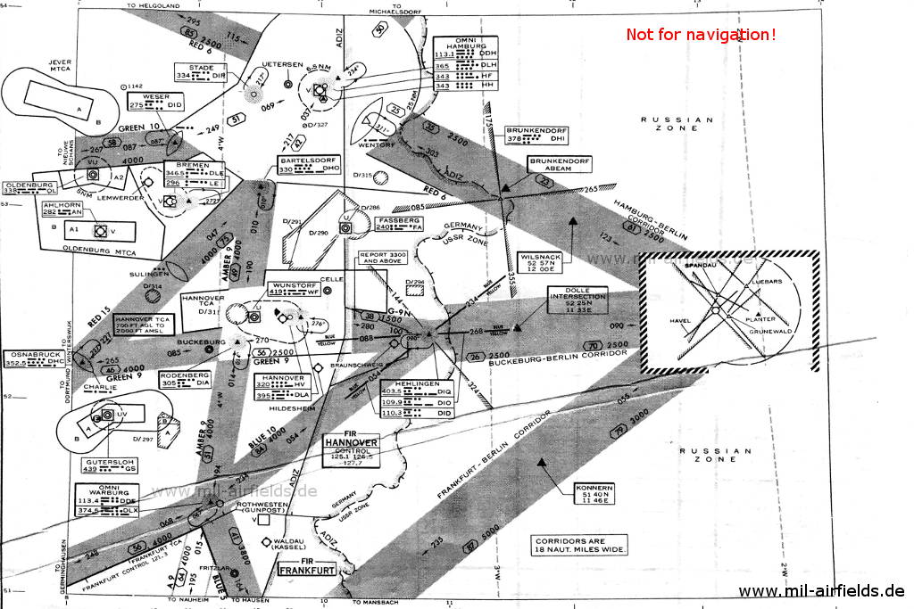
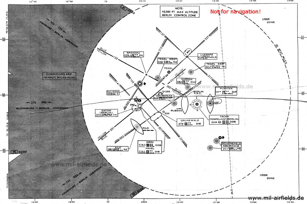
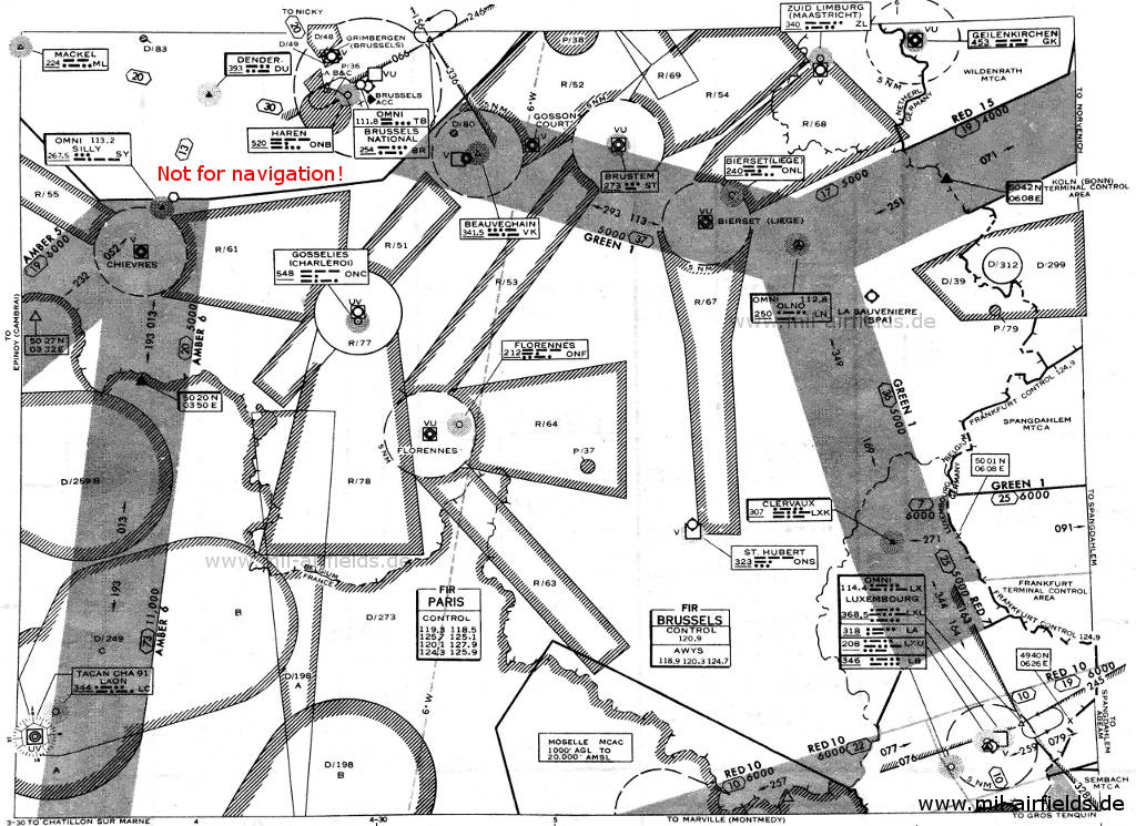
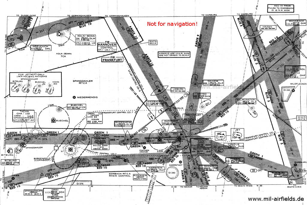
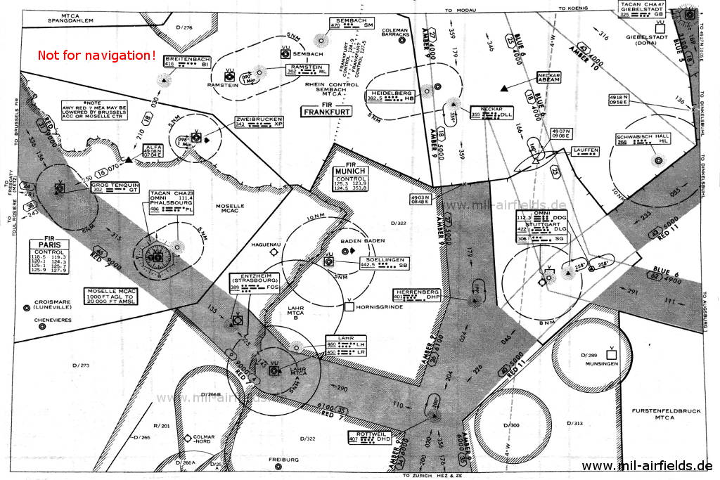
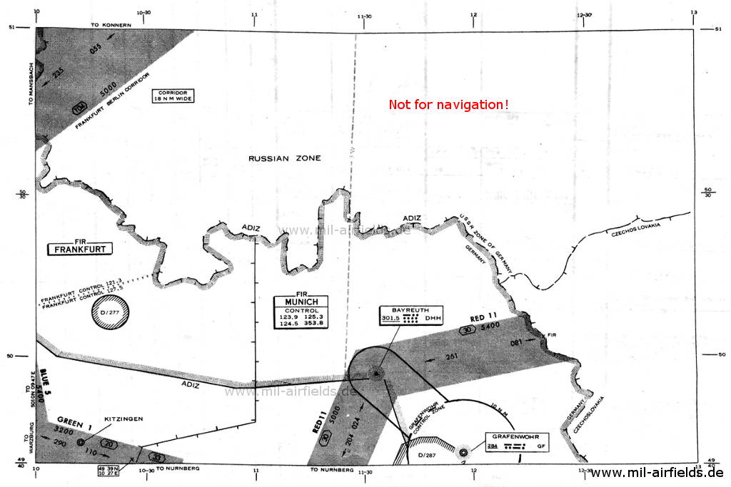
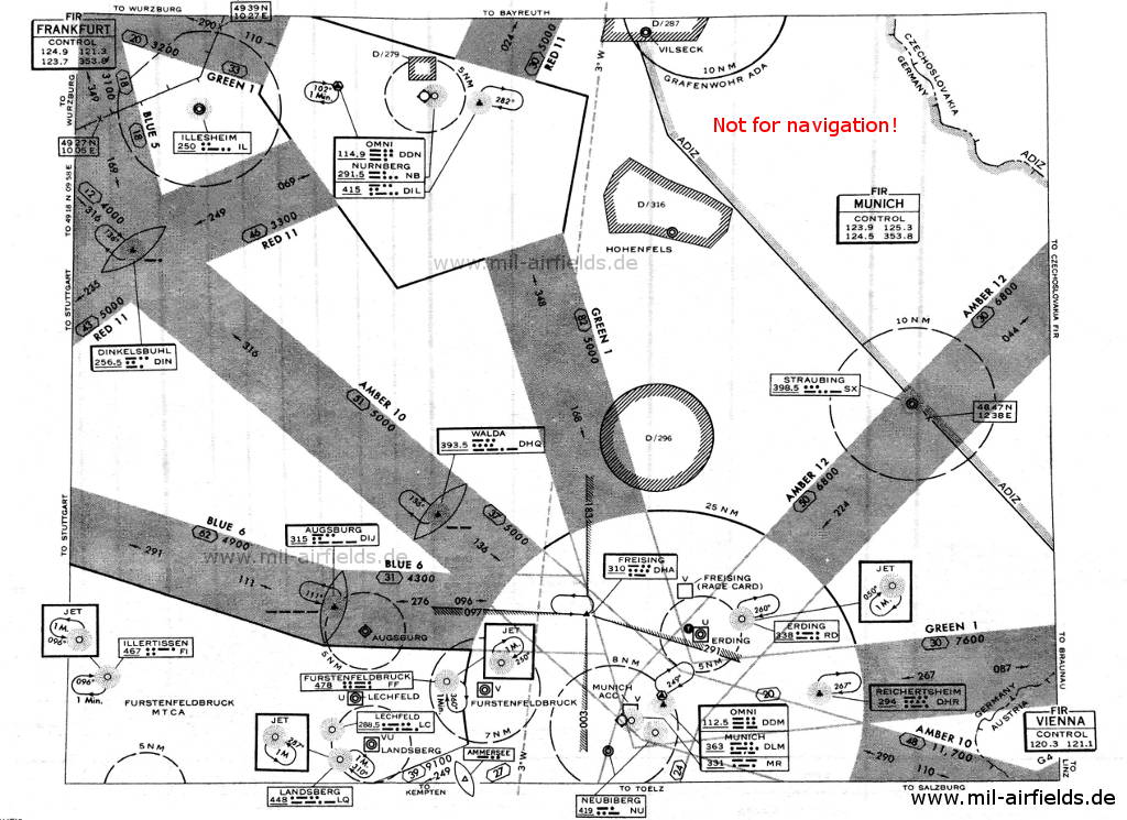
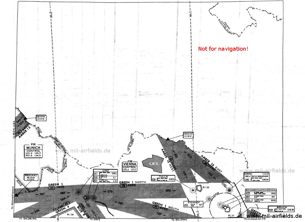
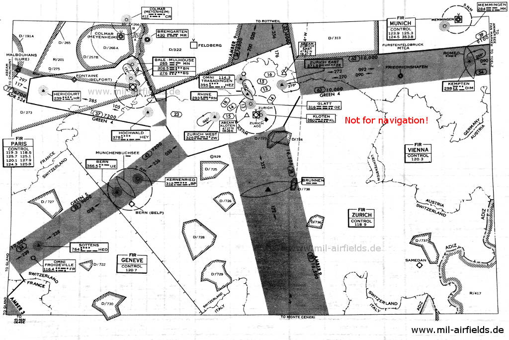
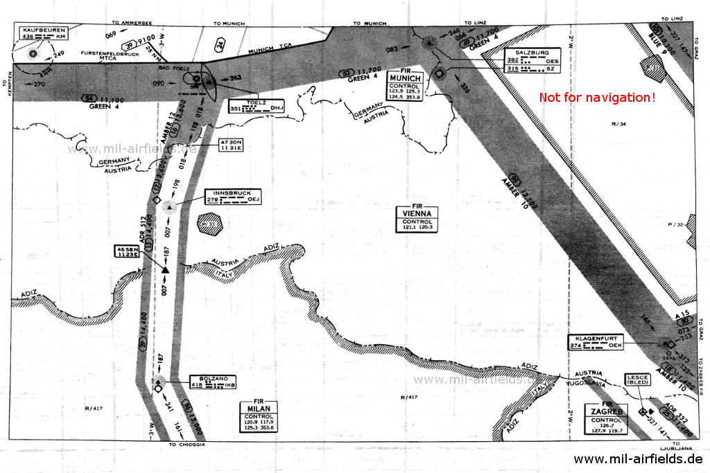
Radio beacons and airways Schleswig-Holstein, Germany, 1959
Schleswig-Holstein - northern part (bottom) (Source: US DoD)
Radio beacons Jever, Dortmund, Dusseldorf, Germany
Border to the Netherlands (Source: US DoD)
Radio beacons RAF airfields in Germany: Laarbruch, Brüggen, Wildenrath
Enlargement: RAF airfields Laarbruch, Brüggen, Wildenrath at the bottom right (Source: US DoD)
Radio beacons Bremen, Hamburg, Hannover, Berlin, Germany
Bremen, Hamburg, Hannover, Berlin (Source: US DoD)
Radio beacons Berlin Gatow, Tegel, Tempelhof, Schönefeld, Germany
Enlargement: Berlin - In addition to the airfields of the Western Allies at Gatow, Tegel and Tempelhof, also the fields at Dallgow and Schönefeld in the Soviet occupation zone (GDR) are marked. The location of the Schoenefeld radio beacons is probably incorrect. The dotted circle marks Berlin control zone, in which Western Allied aircraft can move freely up to an altitude of 10,000 feet. The shaded areas on the left are the three air corridors to Berlin. (Source: US DoD)
Radio beacons Geilenkirchen
Border to the Netherlands, Belgium and Luxembourg (Source: US DoD)
Funkfeuer Cologne/Bonn, Bitburg, Spangdahlem, Frankfurt/M
Area Cologne/Bonn, Eifel, Frankfurt/M - Die Luftstraße "Red 10" als Verlängerung des südlichen Korridors zwischen den Funkfeuern Mansbach und Fulda ist mit 18 Seemeilen in der Breite des Korridors ausgeführt und damit deutlich breiter als die sonst üblichen 10 Seemeilen. (Source: US DoD)
Radio beacons Ramstein, Sembach, Heidelberg, Mannheim, Stuttgart, Söllingen, Lahr, Germany
Pfalz, Mannheim/Heildeberg, Stuttgart, Baden (Source: US DoD)
Radio beacons Bayreuth, Grafenwöhr, Germany
Bayreuth area with airway RED 11 to Czechoslovakia (Source: US DoD)
Radio beacons Nuremberg, Munich
Area Nuremberg, Munich (Source: US DoD)
Radio beacons Linz, Vienna
Border to Czechoslovakia and Austria (Source: US DoD)
Radio beacons Zurich, Bern, Memmingen
Border to Switzerland and Austria (Source: US DoD)
Radio beacons Kaufbeuren, Bad Tölz, Innsbruck, Salzburg, Klagenfurt
Border to Austria (Source: US DoD)

Explanations

Abbreviations

approx.approximately
civcivilcivil operator
GPGlide pathGlide path transmitter
ILSInstrument Landing System(Approach and landing aid)
IMInner MarkerMarker beacon just in front the runway
kHzKilohertz(Unit for frequency)
LLocatorNon-directional beacon for the approach
LLZLocalizerLocalizer transmitter
LMMLocator Middle MarkerCombination of Middle Marker and Locator
LOMLocator Outer MarkerCombination of Outer Marker and Locator
mMeter(Unit for length)
MHzMegahertz(Unit for frequency)
milmilitarymilitary operator
MMMiddle MarkerMarker beacon
NDBNon-directional beaconNon-directional beacon on long or medium waves
NMNautical Miles(Unit for length)
OMOuter MarkerMarker beacon
PRMGПРМГ Посадочная радиомаячная группаSoviet / russian military instrument landing system
RSBNРСБН Rадиотехническая система ближней навигацииSoviet / russian military radio navigation system
SBAStandard Beam ApproachApproach system, Lorenz system, predecessor of the ILS
THRThresholdRunway threshold (most often with number of runway)
transf.transformedCoordinates were converted from a different reference system, therefore there may be deviations.
VARVisual-Aural Rnange
VORVHF Omnidirectional Radio Range
WWatt(Unit for power)
WGS84World Geodetic System 1984(geospatial reference system, GPS coordinates)

Operator

Directory


For historical information only, do not use for navigation or aviation purposes!

Ahlhorn: Air Base (RAF Ahlhorn)


Ahlhorn: NDB (GAF)
N525255 E0081403 (WGS84, transf.) Google Maps
AN, 282 kHz, 30 W
Operated H24.

Ammersee: Fan Marker
N480013 E0111236 (WGS84, transf.) Google Maps
D, 75 MHz
Operated H24.
Frieding

Augsburg: Fan Marker
N482327 E0104741 (WGS84, transf.) Google Maps
4 Dashes, 75 MHz
Operated H24.
Hainhofen
Augsburg: NDB
N482320 E0104735 (WGS84, transf.) Google Maps
DIJ, 315 kHz
Operated H24.
Hainhofen

Bartelsdorf: NDB
N530725 E0092936 (WGS84, transf.) Google Maps
DHO, 330 kHz
Operated H24.

Bayreuth: NDB
N495652 E0113306 (WGS84, transf.) Google Maps
DHH, 301.5 kHz
Operated H24.

Bitburg: Air Base


Runway 24:
Bitburg: NDB (USAF)
N4959 E00640 (approx.), 240°/4.6 NM to field Google Maps
DHB, 220 kHz, 400 W
Operated H24.

For historical information only, do not use for navigation or aviation purposes!

Breitenbach: NDB (USAF)
N4925 E00715 (approx.) Google Maps
BI, 416 kHz, 50 W
Operated H24.

Brekendorf: Eureka (RAF?)
N5426 E00938 (approx.) Google Maps
SC, 225R/235T MHz

Bremen: Airport


Runway 27:
Bremen: LLZ 27
N530247 E0084625 (WGS84, transf.) Google Maps
DLE, 110.9 MHz
Operated H24.
Bremen: GP 27
N530243 E0084803 (WGS84, transf.) Google Maps
330.8 MHz
Glide path 2.8°. Operated H24.
Bremen: NDB/OM
N530257 E0085431 (WGS84, transf.), 272°/3.75 NM to THR 27 Google Maps
NDB: DLE, 346.5 kHz
Outer Marker: Dashes, 75 MHz
Operated H24.
Hemelingen
Bremen: L
N530251 E0084916 (WGS84, transf.), 272°/0.6 NM to THR 27 Google Maps
LE, 296
Operated H24.
Bremen: MM
N530251 E0084918 (WGS84, transf.), 272°/0.6 NM to THR 27 Google Maps
Dashes Dots, 75 MHz
Operated H24.

Bremgarten: Air Base


Bremgarten: NDB (FAF)
N4754 E00737 (approx.) Google Maps
MR, 430 kHz, 250 W
Operated from sunrise-30 until sunset + 45, other times on request 12 hours.

Brüggen: Air Base (RAF Bruggen, Elmpt Station, Javelin Barracks)


Brüggen: BABS (RAF)
Brüggen: NDB (RAF)
N511233 E0060734 (WGS84, transf.) Google Maps
BG, 357 kHz
Located at field. Operated H24.

Brünkendorf: Range
N530409 E0112409 (WGS84, transf.) Google Maps
DHI, 378 kHz
The four predefined legs were: 085°A, 175°N, 265°A and 355°N. Operated H24.
Höhbeck-Vietze

Büchel: Air Base


Runway 21:
Büchel: NDB (GAF)
N501616 E0070808 (WGS84, transf.) Google Maps
ZK, 420 kHz, 45 W
Test operations. Operated Monday to Friday from sunrise-30 until sunset, Saturday sunrise-30 until 1200.
Monreal Polcher Holz

For historical information only, do not use for navigation or aviation purposes!

Charlie: NDB
N495750 E0090009 (WGS84, transf.) Google Maps
DLO, 370 kHz
Operated H24, on test.
Babenhausen

Dinkelsbühl: NDB/Fan Marker
N490941 E0101059 (WGS84, transf.) Google Maps
NDB: DIN, 256.5 kHz
Fan Marker: N, 75 MHz
Operated H24.
Leukershausen

Dortmund: NDB
N513558 E0072311 (WGS84, transf.) Google Maps
DIO, 366.5 kHz
Operated H24.
Waltrop-Brockenscheidt
Dortmund: VOR
N513552 E0072325 (WGS84, transf.) Google Maps
DDC, 113.7 MHz
Operated intermittently on test.
Waltrop-Brockenscheidt

Düsseldorf: Airport


Düsseldorf: VOR
N511659 E0064513 (WGS84, transf.) Google Maps
DDI, 115.4 MHz
At field.
Runway 06:
Düsseldorf: OM 06
N511427 E0064013 (WGS84, transf.), 057°/3.85 NM to THR 06 Google Maps
Dashes, 75 MHz
Meerbusch-Büderich
Runway 24:
Düsseldorf: LLZ 24
N511643 E0064501 (WGS84, transf.) Google Maps
DLI, 109.9 MHz
Operated H24.
Düsseldorf: GP 24
333.8 MHz
Operated H24.
Düsseldorf: NDB
N512053 E0065327 (WGS84, transf.), 236°/5.27 NM to THR 24 Google Maps
DLI, 431 kHz
Operated H24.
Ratingen-Breitscheid
Düsseldorf: OM 24
N511959 E0065158 (WGS84, transf.), 237°/4.0 NM to THR 24 Google Maps
Dashes, 75 MHz
Operated H24.
Ratingen-Lintorf
Düsseldorf: LMM 24
N5118 E00648 (approx.), 237°/0.65 NM to THR 24 Google Maps
Locator: LI, 323 kHz
Middle Marker: Dots Dashes, 75 MHz
Operated H24.

Erding: Air Base (Erding Air Depot)


Erding: Racon
N4819 E01156 (approx.) Google Maps
2-1-2-1, 9310 MHz
Located at field.
Runway 26:
Erding: NDB (GAF)
N482024 E0120342 (WGS84, transf.), 261°/3.7 NM to field Google Maps
RD, 338 kHz, 50 W
Operated H24.
Ottering

Faßberg: L (GAF)
N525024 E0101000 (approx.) Google Maps
FA, 240, 100 W
Operated Monday to Friday from 0600 to 1600, Saturday from 0600 to 1100, Sundays on request.

Feldberg: Racon (USAF)
N5014 E00826 (approx.), 207°/12.24 NM to Wiesbaden Air Base Google Maps
2-2, 9310 MHz
Atop the Feldberg mountain. Operated continously.

For historical information only, do not use for navigation or aviation purposes!

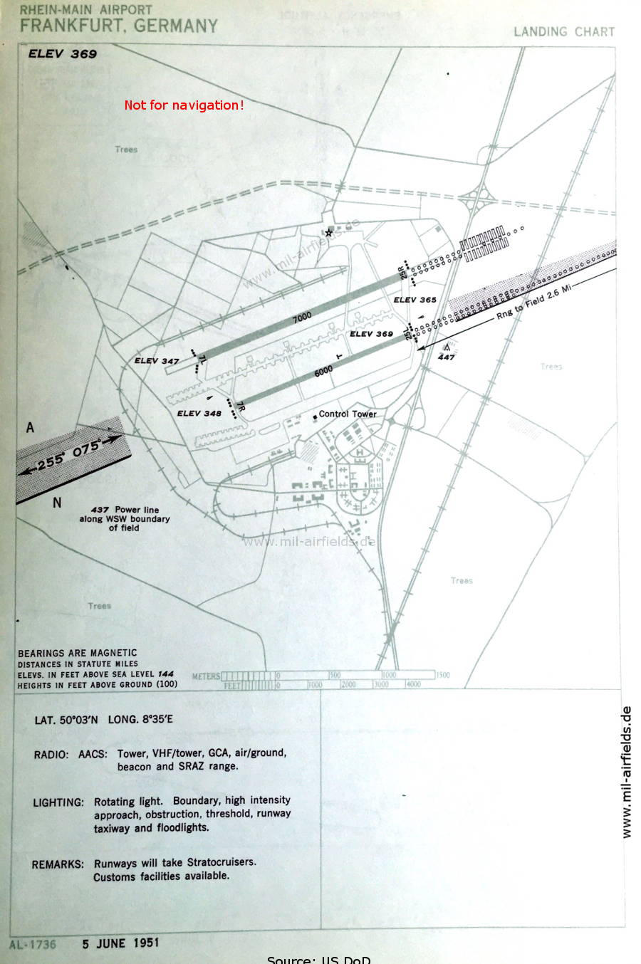
Frankfurt/M: Rhein/Main Air Base, Airport


Frankfurt/M: VOR
N500216 E0083349 (WGS84, transf.), 041°/0.2 NM to field Google Maps
DDF, 112.1 MHz
Transmission of airport weather. Operated H24.
Runway 25R:
Frankfurt/M: LLZ 25R
N500201 E0083257 (WGS84, transf.) Google Maps
DLF, 109.5 MHz
Operated H24.
Frankfurt/M: GP 25R
N500251 E0083526 (WGS84, transf.) Google Maps
332.6 MHz
Glide path 2.7°. Operated H24.
Frankfurt/M: NDB
N500409 E0084126 (WGS84, transf.), 254°/3.93 NM to THR 25R Google Maps
DLF, 297 kHz, 100 W
Operated H24.
Frankfurt/M: OM 25R
N500409 E0084125 (WGS84, transf.), 254°/3.93 NM to THR 25R Google Maps
Dashes, 75 MHz
Operated H24.
Frankfurt/M: Range/Z Marker
N500317 E0083901 (WGS84, transf.), 262°/2.25 NM to THR 25R Google Maps
Range: DIF, 349 kHz
Z Marker: 75 MHz
Operated H24.
Frankfurt/M: LMM 25R
N500301 E0083637 (WGS84, transf.), 254°/0.65 NM to THR 25R Google Maps
Locator: LF, 240 kHz, 100 W
Middle Marker: Dots Dashes, 75 MHz
Operated H24.

Freising: Range/Z Marker
N482212 E0113433 (WGS84, transf.) Google Maps
Range: DHA, 310 kHz
Z Marker: 75 MHz
The four predefined courses to the Range were 003°A, 097°N, 183°A and 291°N. There are splits on inbound track 291° (M) in northern direction. Operated H24.
Fahrenzhausen-Appercha

Fulda: Range/Z Marker
N503413 E0093646 (WGS84, transf.) Google Maps
Range: DHF, 315 kHz
Z Marker: 75 MHz
The four predefined courses to the Range were 050°A, 164°N, 230°A and 344°N. Operated H24.
Fulda: VOR
N503426 E0093655 (WGS84, transf.) Google Maps
DDL, 112.9 MHz
Operated intermittently on test.
Trätzhof

Fürstenfeldbruck: Air Base (Fürstenfeldbruck Airfield)


Fürstenfeldbruck: NDB (GAF)
N481326 E0110855 (WGS84, transf.), 107°/22.7 NM to München-Riem Google Maps
FF, 478 kHz, 400 W
Operated H24.

Geilenkirchen: Air Base (RAF Geilenkirchen, Teveren)


Geilenkirchen: NDB (RAF)
N5058 E00603 (approx.) Google Maps
GK, 453 kHz, 200 W
Located at field. Operated Monday, Tuesday, Thursday and Friday from 0715 to 1100, Wednesday, Saturday from 0715 to 1100. Maintenance period Friday from 0730 to 1600.

Germinghausen: NDB/Fan Marker
N5104 E00746 (approx.) Google Maps
NDB: DHG, 489 kHz
Fan Marker: G, 75 MHz
Operated H24.

Giebelstadt: Air Base, Army Airfield AAF


Giebelstadt: NDB (USAF)
N4939 E00958 (approx.) Google Maps
GB, 325 kHz, 50 W
Located at field. Operated H24.
Giebelstadt: TACAN (USAF)
074°/1.28 NM to field
GB, CH47

For historical information only, do not use for navigation or aviation purposes!

Grafenwöhr: Army Air Field (Grafenwöhr AAF)


Grafenwöhr: NDB (US Army)
N4942 E01157 (approx.) Google Maps
GF, 284 kHz, 50 W
Located at field. Operated Monday to Friday from 0700 to 1600, Saturday from 0700 to 1100; other times on 60 minutes request.

Gütersloh: Air Base (RAF Gutersloh)


Gütersloh: BABS (RAF)
Gütersloh: Eureka (RAF)
N5156 E00819 (approx.) Google Maps
GS, 213T/223R MHz
Gütersloh: Eureka (RAF)
N5156 E00819 (approx.) Google Maps
GS, 235T/230R MHz
Gütersloh: NDB (RAF)
N5156 E00819 (approx.) Google Maps
GS, 439 kHz, 200 W
Located at field. Operated H24.

Hahn: Air Base


Hahn: TACAN (USAF)
217°/6.4 NM to field
AH, CH24
Located at field.
Hahn: VOR (USAF)
AH, 113.0 MHz
Runway 22:
Hahn: NDB (USAF)
N500151 E0072042 (WGS84, transf.), 217°/6.4 NM to field Google Maps
AH, 482 kHz, 75 W
Operated H24.
Between Haserich and Leideneck

Hamburg: Fuhlsbüttel Airport


Hamburg: VOR
N533746 E0095932 (WGS84, transf.) Google Maps
DDH, 113.1 MHz
Located at field. Operated H24.
Runway 05:
Hamburg: OM 05
053°/4.02 NM to THR 05
2 Dots, 1 Dash, 1 Dot, 75 MHz
Operated H24.
Runway 23:
Hamburg: LLZ 23
N533715 E0095807 (WGS84, transf.) Google Maps
DLH, 110.1 MHz
Operated H24.
Hamburg: GP 23
334.4 MHz
Glide path 3°. Operated H24.
Hamburg: NDB
N534115 E0100605 (WGS84, transf.), 233°/4.9 NM to THR 23 Google Maps
DLH, 365 kHz, 500 W
Operated H24, Maintenance period from 0600 to 0700.
Hamburg: OM
N534035 E0100454 (WGS84, transf.), 234°/3.9 NM to THR 23 Google Maps
Dashes, 75 MHz
Operated H24.
Hamburg: LMM
N533829 E0100037 (WGS84, transf.), 233°/0.53 NM to THR 23 Google Maps
Locator: HF, 343 kHz
Middle Marker: Dots-Dashes, 75 MHz
Operated H24. NDB "HF" is operated alternatively to Locator "HH" on the same frequency, depending on the runway in use.
Runway 34:
Hamburg: L
N533722 E0100009 (WGS84, transf.), 337°/0.26 NM to THR 34 Google Maps
HH, 343
Locator "HH" is operated alternatively to NDB "HF" on the same frequency, depending on the runway in use.

Hannover: Langenhagen Airport


Runway 28:
Hannover: LLZ 28
N522719 E0094022 (WGS84, transf.) Google Maps
DLA, 109.5 MHz
Operated H24.
Hannover: GP 28
332.6 MHz
Glide path 2.75°. Operated H24.
Hannover: NDB/OM
N522704 E0094854 (WGS84, transf.), 276°/3.8 NM to THR 28 Google Maps
NDB: DLA, 395 kHz
Outer Marker: Dashes, 75 MHz
Operated H24.
Hannover: LMM
N522713 E0094340 (WGS84, transf.), 276°/0.6 NM to THR 28 Google Maps
Locator: HV, 320 kHz
Middle Marker: Dots-Dashes, 75 MHz
Operated H24.

Hausen: Fan Marker
N505112 E0092742 (WGS84, transf.) Google Maps
4 Dashes, 75 MHz
Operated H24.
Oberaula-Hausen

Hehlingen: LLZ
N522127 E0105145 (WGS84, transf.) Google Maps
DIO, 109.9 MHz
Courses 088°/268°, blue indication north, yellow indication south. Operated H24.
This localizer was not located at an airport, but was used as a navigation aid in the central corridor to Berlin.
Hehlingen: NDB
N522249 E0105101 (WGS84, transf.) Google Maps
DIQ, 403.5 kHz
Operated H24.
Hehlingen: VAR
N522139 E0105152 (WGS84, transf.) Google Maps
DID, 110.3
Courses: 054°, 234° visual; 144°, 324° aural; blue indication north, yellow indication south; N-keying east, A-keying west. Operated H24.

For historical information only, do not use for navigation or aviation purposes!

Heidelberg: Army Air Field AAF (Army Heliport AHP, Pfaffengrund)


Runway 08:
Heidelberg: NDB (US Army)
N4923 E00836 (approx.), 085°/1.9 NM to field Google Maps
HB, 382.5 kHz, 75 W
Operated H24.

Helgoland: NDB
N541054 E0075257 (WGS84, transf.) Google Maps
DHE, 397.2 kHz
Operated H24.Maintenance period daily from 0600 to 0700.

Herrenberg: NDB
N483654 E0085043 (WGS84, transf.) Google Maps
DHP, 401 kHz
Operated H24.
Kuppingen

Illertissen: NDB (GAF)
N481327 E0100656 (WGS84, transf.), 092°/46.3 NM to Fürstenfeldbruck airfield Google Maps
FI, 467 kHz, 50 W
Operated H24.

Illesheim: Army Air Field AAF (Storck Barracks, Army Heliport AHP)


Illesheim: NDB (US Army)
N4928 E01023 (approx.) Google Maps
IL, 250 kHz, 50 W
Located at field. Operated Monday to Saturday from 0700 to 1600.

Jever: Air Base (Upjever, RAF Jever, Schortens)


Jever: Eureka (RAF)
N5332 E00753 (approx.) Google Maps
JV, 230R/225T MHz
Located at field.
Jever: NDB (RAF)
N5332 E00753 (approx.) Google Maps
JV, 368 kHz, 300 W
Located at field. Operated Monday to Friday from 0700 to 1600, Saturday from 0700 to 1100.

Kaufbeuren: Air Base


Kaufbeuren: NDB (GAF)
N4752 E01037 (approx.), 116°/0.22 NM to field Google Maps
KM, 436 kHz, 100 W
Operated Monday to Saturday from 0700 to 1600.

For historical information only, do not use for navigation or aviation purposes!

Kempten: NDB/Fan Marker
N474414 E0102005 (WGS84, transf.) Google Maps
NDB: DIM, 298 kHz, 50 W
Fan Marker: R, 75 MHz
Operated H24.

Kirn: NDB
N495054 E0072227 (WGS84, transf.) Google Maps
DHK, 392 kHz
Operated H24.
Bundenbach
Kirn: VOR
N495201 E0072211 (WGS84, transf.) Google Maps
DDK, 117.5 MHz
Operated H24, on test.
Between Rhaunen and Hausen

Köln-Bonn: Airport (Cologne, Wahner Heide, RAF Wahn)


Runway 25:
Köln-Bonn: LLZ 25
N505134 E0070715 (WGS84, transf.) Google Maps
DLW, 109.1 MHz
Operated H24.
Köln-Bonn: GP 25
331.4 MHz
Glide path 3°. Operated H24.
Köln-Bonn: OM 25
N505354 E0071505 (WGS84, transf.), 250°/4.04 NM to THR 25 Google Maps
Dashes, 75 MHz
Operated H24.
Köln-Bonn: NDB
N505341 E0071416 (WGS84, transf.), 250°/3.48 NM to THR 25 Google Maps
DLW, 294 kHz
Operated H24.
Köln-Bonn: LMM
N505224 E0071004 (WGS84, transf.), 250°/0.53 NM to THR 25 Google Maps
Locator: LW, 279.5 kHz
Middle Marker: Dots-Dashes, 75 MHz
Operated H24.

König: NDB/Fan Marker
N494544 E0090528 (WGS84, transf.) Google Maps
NDB: DLK, 435 kHz, 100 W
Fan Marker: M, 75 MHz
Operated H24.
Haingrund, approx. 6 km northeast of Bad König

Laarbruch: Air Base (RAF Laarbruch, Goch, Weeze, Niederrhein)


Laarbruch: BABS (RAF)
Laarbruch: Eureka (RAF)
N5136 E00608 (approx.) Google Maps
LL, 233R/213T MHz
Located at field.
Laarbruch: NDB (RAF)
N5136 E00607 (approx.) Google Maps
LL, 406 kHz
Located at field. Operated from sunrise-30 to sunset+30.

Lahr: Air Base (Base aérienne 139, Canadian Forces Base CFB Lahr, Langenwinkel)


Lahr: NDB (FAF)
N482127 E0074827 (WGS84, transf.), 011°/0.2 NM to field Google Maps
LR, 450 kHz, 250 W
Operated H24.
Lahr: NDB (FAF)
N4827 E00756 (approx.) Google Maps
LH, 460 kHz, 350 W
Operated from 0800 to 1800, except Saturdays, Sundays and holidays.

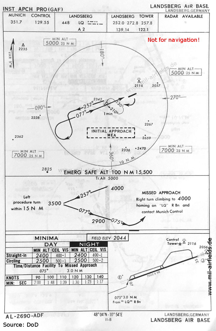
Landsberg/Lech: Air Base (Penzing)


Runway 07:
Landsberg: NDB (GAF)
N480313 E0104851 (WGS84, transf.), 077°/3.2 NM to field Google Maps
LQ, 448 kHz, 50 W
Operated H24.

For historical information only, do not use for navigation or aviation purposes!

Lauffen: Fan Marker
N490726 E0091013 (WGS84, transf.) Google Maps
L, 75 MHz
Operated H24.
Between Heilbronn and Lauffen am Neckar

Lechfeld: Air Base (Klosterlechfeld, Graben)


Runway 03:
Lechfeld: NDB (GAF)
033°/3.8 NM to field
LC, 288.5 kHz
Operated on test.

Lima: NDB/Fan Marker
N5122 E00624 (approx.) Google Maps
NDB: DF, 311 kHz
Fan Marker: 75 MHz
Operated on test.
Near Kempen

Limburg: Fan Marker
N502558 E0081939 (WGS84, transf.) Google Maps
4 Dashes, 75 MHz
Operated H24.
Aulenhausen

Mansbach: VAR
N504629 E0095428 (WGS84, transf.) Google Maps
DIM, 110.9
Courses: 055°, 235° visual, 145°, 325° aural. Operated H24.
Between Mansbach and Soisdorf

Marxheim: NDB (USAF)
N5004 E00825 (approx.), 260°/3.0 NM to Wiesbaden Airfield Google Maps
MX, 320 kHz, 50 W
Operated H24. Giebelstadt NDB interfereing in northwestern quadrant.

Memmingen: Air Base (Memmingerberg, Memmingen Airport, Allgäu Airport)


Runway 06:
Memmingen: NDB (GAF)
N475921 E0101308 (WGS84, transf.), 063°/4.5 NM to field Google Maps
MK, 284 kHz
Operated on test in irregular intervals.

For historical information only, do not use for navigation or aviation purposes!

Metro: NDB
N501648 E0085111 (WGS84, transf.), 219°/17.0 NM to Frankfurt Rhein/Main airport Google Maps
DHN, 289 kHz, 100 W
Operated H24.
Between Bönstadt and Erbstadt

Michaelsdorf: NDB
N541838 E0110260 (WGS84, transf.) Google Maps
DHM, 338 kHz, 150 W
Operated H24.

Modau: NDB
N494726 E0084427 (WGS84, transf.), 341.5°/16.2 NM to Frankfurt Rhein/Main airport Google Maps
DLP, 310 kHz, 100 W
Operated H24.

Munich: Riem Airport (München, Munich Old Airport)


Runway 25:
München: LLZ 25
N480737 E0114103 (WGS84, transf.) Google Maps
DLM, 109.5 MHz
Operated H24.
München: GP 25
N480755 E0114225 (WGS84, transf.) Google Maps
332.6 MHz
Glide path 2.8°. Operated H24.
München: VOR
N481050 E0114858 (WGS84, transf.), 241°/5.2 NM to THR 25 Google Maps
DDM, 112.5 MHz
Operated H24.
Bei Poing / Ottersberg.
München: NDB/OM
N480953 E0114839 (WGS84, transf.), 249°/4.4 NM to THR 25 Google Maps
NDB: DLM, 363 kHz
Outer Marker: Dashes, 75 MHz
Operated H24.
Poing
München: LMM
N480816 E0114320 (WGS84, transf.), 249°/0.54 NM to THR 25 Google Maps
Locator: MR, 331 kHz
Middle Marker: Dot Dash, 75 MHz
Operated H24.

Nauheim: NDB
N502737 E0084601 (WGS84, transf.) Google Maps
DLZ, 408.5 kHz, 100 W
Operated H24.
Near Münzenberg

Neckar: NDB
N492008 E0084356 (WGS84, transf.) Google Maps
DLL, 355 kHz
Operated H24.
Between Ochsenbach and Maisbach

Neubiberg: Airfield (Neubiberg Air Base)


Runway 26:
Neubiberg: NDB (GAF)
N480622 E0114755 (WGS84, transf.), 257°/6.05 to field Google Maps
NU, 419 kHz, 45 W
Operated H24.
Vaterstetten

For historical information only, do not use for navigation or aviation purposes!

Nierstein: NDB/Z Marker
N495260 E0082339 (WGS84, transf.) Google Maps
NDB: DLV, 399 kHz
Z Marker: V, 75 MHz
Operated H24, on test.

Nörvenich: Air Base (Düren)


Nörvenich: NDB (civ)
N505005 E0063756 (WGS84, transf.), 170°/0.54 NM to field Google Maps
DHL, 415 kHz
Operated H24.

Nuremberg: Airport (Nürnberg)


Runway 10:
Nürnberg: VOR
N493125 E0104833 (WGS84, transf.), 102°/10.3 NM to THR 10 Google Maps
DDN, 114.9 MHz
Operated H24.
Nürnberg: OM 10
N493035 E0105817 (WGS84, transf.), 102°/3.9 NM to THR 10 Google Maps
Dashes, 75 MHz
Operated on test.
Runway 28:
Nürnberg: LLZ 28
N492956 E0110359 (WGS84, transf.) Google Maps
DLN, 109.1 MHz
Operated H24.
Nürnberg: GP 28
N492953 E0110533 (WGS84, transf.) Google Maps
331.4 MHz
Glide path 2.8°. Operated H24.
Nürnberg: NDB
N492853 E0111512 (WGS84, transf.), 282°/6.18 NM to THR 28 Google Maps
DIL, 415 kHz
Operated H24.
Nürnberg: OM 28
N492909 E0111142 (WGS84, transf.), 282°/3.9 NM to THR 28 Google Maps
Dashes, 75 MHz
Operated H24.
Nürnberg: LMM
N492940 E0110639 (WGS84, transf.), 282°/0.57° to THR 28 Google Maps
Locator: NB, 291.5 kHz
Middle Marker: Dots Dashes, 75 MHz
Operated H24.

Oldenburg: Air Base


Oldenburg: NDB (GAF)
N5311 E00810 (approx.) Google Maps
OL, 338 kHz, 400 W
Operated H24. Maintenance period from 0600 to 0700 daily.

Osnabrück: NDB/Fan Marker
N521203 E0080554 (WGS84, transf.) Google Maps
NDB: DHC, 352.5 kHz
Fan Marker: C, 75 MHz
Operated H24, on test.

Ramstein: Air Base (Landstuhl Air Base, Landstuhl-Ramstein)


Runway 27:
Ramstein: NDB (USAF)
N492635 E0074354 (WGS84, transf.), 271°/4.8 NM to field Google Maps
RL, 362 kHz
Operated H24.

Reichertsheim: NDB
N481060 E0121736 (WGS84, transf.) Google Maps
DHR, 294 kHz
Operated H24.

For historical information only, do not use for navigation or aviation purposes!

Rodenberg: NDB
N521926 E0092001 (WGS84, transf.) Google Maps
DIA, 305 kHz
Operated H24.

Rottweil: NDB
N481225 E0083844 (WGS84, transf.) Google Maps
DHD, 407 kHz
Operated H24.

Rüdesheim: NDB/Fan Marker
N500156 E0075639 (WGS84, transf.) Google Maps
NDB: DLR, 338 kHz, 100 W
Fan Marker: O, 75 MHz
Operated H24.

Salmünster: NDB
N501613 E0092540 (WGS84, transf.) Google Maps
DLJ, 276.5 kHz, 100 W
Operated H24.

Schwäbisch Hall: Hessental Army Airfield AAF (Hessental, Camp Dolan, Dolan Barracks, Adolf Würth Airport)


Schwäbisch Hall: NDB (US Army)
N4907 E00947 (approx.) Google Maps
HL, 268 kHz, 50 W
Located at field. Operated H24.

Sembach: Air Base (Sembach Air Base)


Runway 25:
Sembach: NDB (USAF)
N493408 E0080310 (WGS84, transf.), 246°/7.1 NM to field Google Maps
SM, 470 kHz, 100 W
Operated H24.

Söllingen: Air Base (Canadian Forces Base Söllingen, Karlsruhe/Baden-Baden Airport, Baden Söllingen)


Söllingen: NDB (RCAF)
N4846 E00806 (approx.) Google Maps
SB, 442.5 kHz, 100 W
Located at field. Operated H24.

For historical information only, do not use for navigation or aviation purposes!

Spangdahlem: Air Base


Spangdahlem: TACAN (USAF)
228°/9.6 NM
PF, CH102
Operated on test.
Spangdahlem: VOR (USAF)
N4959 E00642 (approx.) Google Maps
PF, 113.9 MHz
Located at field. Operated H24.
Runway 23:
Spangdahlem: NDB (USAF)
N5002 E00647 (approx.), 232°/4.2 NM to field Google Maps
PF, 427.5 kHz, 35 W
Operated H24.

Stade: NDB
N533606 E0092609 (WGS84, transf.) Google Maps
DIR, 334 kHz
Operated H24.

Straubing: NDB (US Army)
N4849 E01235 (approx.) Google Maps
SX, 398.5 kHz, 50 W
Located at field. Operated H24.

Stuttgart: Airport, Army Airfield (Echterdingen AAF)


Runway 08:
Stuttgart: OM 08
N483948 E0090458 (WGS84, transf.), 078°/4.53 NM to THR 08 Google Maps
Dashes, 75 MHz
Operated H24.
Runway 26:
Stuttgart: LLZ 26
N484100 E0091117 (WGS84, transf.) Google Maps
DLG, 109.9 MHz
Operated H24.
Stuttgart: GP 26
333.8 MHz
Operated H24.
Stuttgart: VOR
N484410 E0092702 (WGS84, transf.), 257°/9.75 NM to THR 26 Google Maps
DDG, 112.3 MHz
Operated H24.
Stuttgart: NDB
N484235 E0091934 (WGS84, transf.), 258°/4.55 NM to THR 26 Google Maps
DLG, 422 kHz
Operated H24.
Stuttgart: OM 26
N484235 E0091928 (WGS84, transf.), 258°/4.55 NM to THR 26 Google Maps
Dashes, 75 MHz
Operated H24.
Stuttgart: LMM
N484134 E0091353 (WGS84, transf.), 258°/0.64 NM to THR 26 Google Maps
Locator: SG, 306 kHz
Middle Marker: Dots Dashes, 75 MHz
Operated H24.

Sulingen: Fan Marker
N524118 E0084932 (WGS84, transf.) Google Maps
S, 75 MHz
Operated on test.

Westerland: Airport Sylt (RAF Sylt)


Sylt: NDB (RAF)
N5455 E00820 (approx.), 015°/1.0 NM to airfield Google Maps
SL, 286 kHz, 200 W
Operated Monday to Friday from sunrise-30 to sunset+30, Saturday from sunrise-30 to 1100.

Tölz: NDB/Fan Marker (civ)
N474612 E0113855 (WGS84, transf.), 261°/2.0 NM to Bad Tölz Army Airfield Google Maps
NDB: DHJ, 351 kHz
Fan Marker: J, 75 MHz
Operated H24.

For historical information only, do not use for navigation or aviation purposes!

Walda: NDB/Fan Marker
N483453 E0110702 (WGS84, transf.) Google Maps
NDB: DHQ, 393.5 kHz
Fan Marker: M, 75 MHz
Operated H24.

Warburg: NDB
N512911 E0090532 (WGS84, transf.) Google Maps
DLX, 374.5 kHz
Operated H24.
Warburg: VOR
N513021 E0090639 (WGS84, transf.) Google Maps
DDE, 113.4 MHz
Operated H24.

Wentorf: Fan Marker
N532816 E0102118 (WGS84, transf.) Google Maps
W, 75 MHz
Operated H24.

Weser: NDB/Fan Marker
N532025 E0084901 (WGS84, transf.) Google Maps
NDB: DID, 275 kHz
Fan Marker: D, 75 MHz
Operated H24.

Wiesbaden: Range/Z Marker (civ)
N501160 E0081660 (WGS84, transf.) Google Maps
Range: WB, 331 kHz
Z Marker: 75 MHz
The four predefined courses to the Range were 053°A, 144°N, 233°A and 324°N. Operated H24. Giebelstadt NDB interfereing in northwestern quadrant.

Wiesbaden: Air Base, Army Airfield (Erbenheim)


Runway 26:
Wiesbaden: Marxheim NDB
260°/3.0 NM to THR 26
See Marxheim NDB.

Wildenrath: Royal Air Force Base


Wildenrath: Eureka (RAF)
N5107 E00613 (approx.) Google Maps
WI, 228T/218R MHz
Maintenance period every Friday from 0900 to 1100 and last Friday of each month from 0700 to 1100.
Wildenrath: NDB (RAF)
N5107 E00612 (approx.) Google Maps
WI, 269 kHz, 50 W
Located at field. Operated H24.

Wunstorf: Air Base (Kleinheidorn)


Wunstorf: NDB (GAF)
N5228 E00925 (approx.), 177°/0.7 NM to field Google Maps
WF, 419 kHz, 75 W
Operated Monday to Friday from 0700 to 1600, Saturday from 0700 to 1100. On test.

For historical information only, do not use for navigation or aviation purposes!

Würzburg: NDB/Fan Marker
N494359 E0095717 (WGS84, transf.), 342°/6.3 to Würzburg airfield Google Maps
NDB: DIK, 377 kHz
Fan Marker: K, 75 MHz
Operated H24.

Zweibrücken: Air Base


Zweibrücken: NDB (RCAF)
N4913 E00725 (approx.) Google Maps
XP, 343 kHz, 100 W
Located at field. Operated H24.

For historical information only, do not use for navigation or aviation purposes!


Recommended

Image credits are shown on the respective target page, click on the preview to open it.

Related Topics

Radio beacons Berlin 1958/59
Radio beacons Austria 1950s
Radio beacons Denmark 1950s
Radio beacons France 1950s
Radio beacons Netherlands 1950s
Radio beacons Switzerland 1950s

Navigation

Historical radio beacons

Home