Radio beacons in Malta in the 1950s
For historical information only, do not use for navigation or aviation purposes!
The following list contains the aeronautical radio beacons that were active in Malta in the mid of the 1950s. At that time, Malta was a British colony, that's why you can find navigation aids like Eureka, BABS and YG, which were typical for the British military.
All information is outdated and may not be used for navigational purposes.
Map of radio beacons and airways in 1955
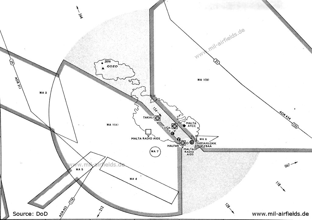
Malta and Gozo - Airfields: Hal Far (Halfar), Luqa, Marsaxlokk seaplane station, Takali (Source: DoD)
Explanations
![]()
Directory of aeronautical radio beacons
For historical information only, do not use for navigation or aviation purposes!
Hal Far: Airfield (Ħal Fa, RAF Halfar, HMS Falcon)
Luqa: Airport (RAF Luqa, Ajruport Internazzjonali ta' Malta, Malta International Airport)
Luqa: BABS (Royal Air Force RAF)
N355101 E0142753 (WGS84, approx.) Google Maps
233R/218T
N355101 E0142753 (WGS84, approx.) Google Maps
233R/218T
To runway 24 (236°). Operated from 0700 to 1900 and on 20 minutes request.
For historical information only, do not use for navigation or aviation purposes!
Abbreviations
| approx. | approximately | |
| civ | civil | civil operator |
| GP | Glide path | Glide path transmitter |
| ILS | Instrument Landing System | (Approach and landing aid) |
| IM | Inner Marker | Marker beacon just in front the runway |
| kHz | Kilohertz | (Unit for frequency) |
| L | Locator | Non-directional beacon for the approach |
| LLZ | Localizer | Localizer transmitter |
| LMM | Locator Middle Marker | Combination of Middle Marker and Locator |
| LOM | Locator Outer Marker | Combination of Outer Marker and Locator |
| m | Meter | (Unit for length) |
| MHz | Megahertz | (Unit for frequency) |
| mil | military | military operator |
| MM | Middle Marker | Marker beacon |
| NDB | Non-directional beacon | Non-directional beacon on long or medium waves |
| NM | Nautical Miles | (Unit for length) |
| OM | Outer Marker | Marker beacon |
| PRMG | ПРМГ Посадочная радиомаячная группа | Soviet / russian military instrument landing system |
| RSBN | РСБН Rадиотехническая система ближней навигации | Soviet / russian military radio navigation system |
| SBA | Standard Beam Approach | Approach system, Lorenz system, predecessor of the ILS |
| THR | Threshold | Runway threshold (most often with number of runway) |
| transf. | transformed | Coordinates were converted from a different reference system, therefore there may be deviations. |
| VAR | Visual-Aural Rnange | |
| VOR | VHF Omnidirectional Radio Range | |
| W | Watt | (Unit for power) |
| WGS84 | World Geodetic System 1984 | (geospatial reference system, GPS coordinates) |
Recommended

Image credits are shown on the respective target page, click on the preview to open it.