Aeronautical radio beacons & maps, Finland 1950s
Suomi: Radiomajakat, Ilmailukartat
For historical information only, do not use for navigation or aviation purposes!
The following list contains the aeronautical radio beacons that were active in Finland in the mid of the 1950s. All information is outdated and may not be used for navigational purposes.
At this time there were exclusivly non-directional beacons (NDB). The identification of the en-route beacons consisted of three letters and began with either OI or OJ. Radio beacons for the approach to airfields had two letters, mostly according to the name of the airfield.
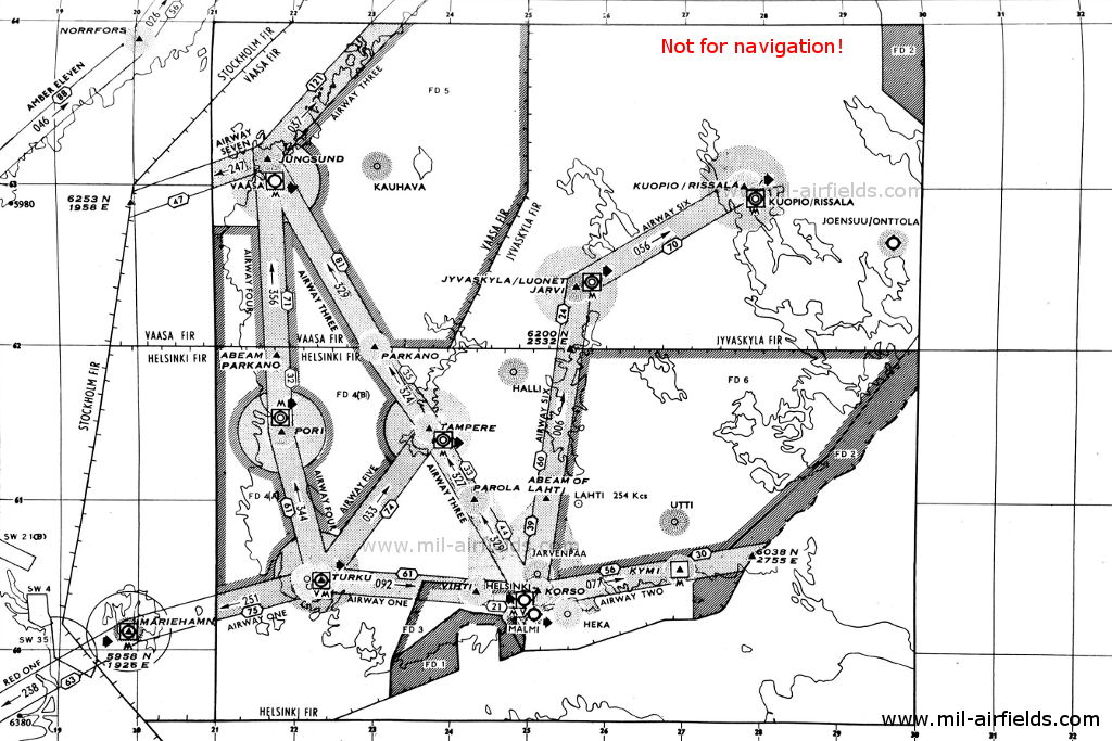
Radio beacons and airways
Northern part (Source: DoD)
Southern part (Source: DoD)
Explanations
![]()
Abbreviations
| approx. | approximately | |
| civ | civil | civil operator |
| GP | Glide path | Glide path transmitter |
| ILS | Instrument Landing System | (Approach and landing aid) |
| IM | Inner Marker | Marker beacon just in front the runway |
| kHz | Kilohertz | (Unit for frequency) |
| L | Locator | Non-directional beacon for the approach |
| LLZ | Localizer | Localizer transmitter |
| LMM | Locator Middle Marker | Combination of Middle Marker and Locator |
| LOM | Locator Outer Marker | Combination of Outer Marker and Locator |
| m | Meter | (Unit for length) |
| MHz | Megahertz | (Unit for frequency) |
| mil | military | military operator |
| MM | Middle Marker | Marker beacon |
| NDB | Non-directional beacon | Non-directional beacon on long or medium waves |
| NM | Nautical Miles | (Unit for length) |
| OM | Outer Marker | Marker beacon |
| PRMG | ПРМГ Посадочная радиомаячная группа | Soviet / russian military instrument landing system |
| RSBN | РСБН Rадиотехническая система ближней навигации | Soviet / russian military radio navigation system |
| SBA | Standard Beam Approach | Approach system, Lorenz system, predecessor of the ILS |
| THR | Threshold | Runway threshold (most often with number of runway) |
| transf. | transformed | Coordinates were converted from a different reference system, therefore there may be deviations. |
| VAR | Visual-Aural Rnange | |
| VOR | VHF Omnidirectional Radio Range | |
| W | Watt | (Unit for power) |
| WGS84 | World Geodetic System 1984 | (geospatial reference system, GPS coordinates) |
Directory
For historical information only, do not use for navigation or aviation purposes!
Halli: Air Base (Kuorevesi, Hallin lentoasema)
Helsinki: Malmi Airfield (Helsinki-Malmin lentoasema)
Runway 19:
Helsinki/Malmi: Järvenpää NDB
182°/15.7 NM to THR 19
182°/15.7 NM to THR 19
See Järvenpää NDB.
Helsinki/Malmi: Korso LOM
182° to THR 19
182° to THR 19
See Korso LOM.
Helsinki/Malmi: Locator
N6015 E02503 (approx.), 182°/0.54 NM to THR 19 Google Maps
M, 408 kHz
N6015 E02503 (approx.), 182°/0.54 NM to THR 19 Google Maps
M, 408 kHz
The locator was slightly displaced to the west of the extended runway centerline. Operated on request.
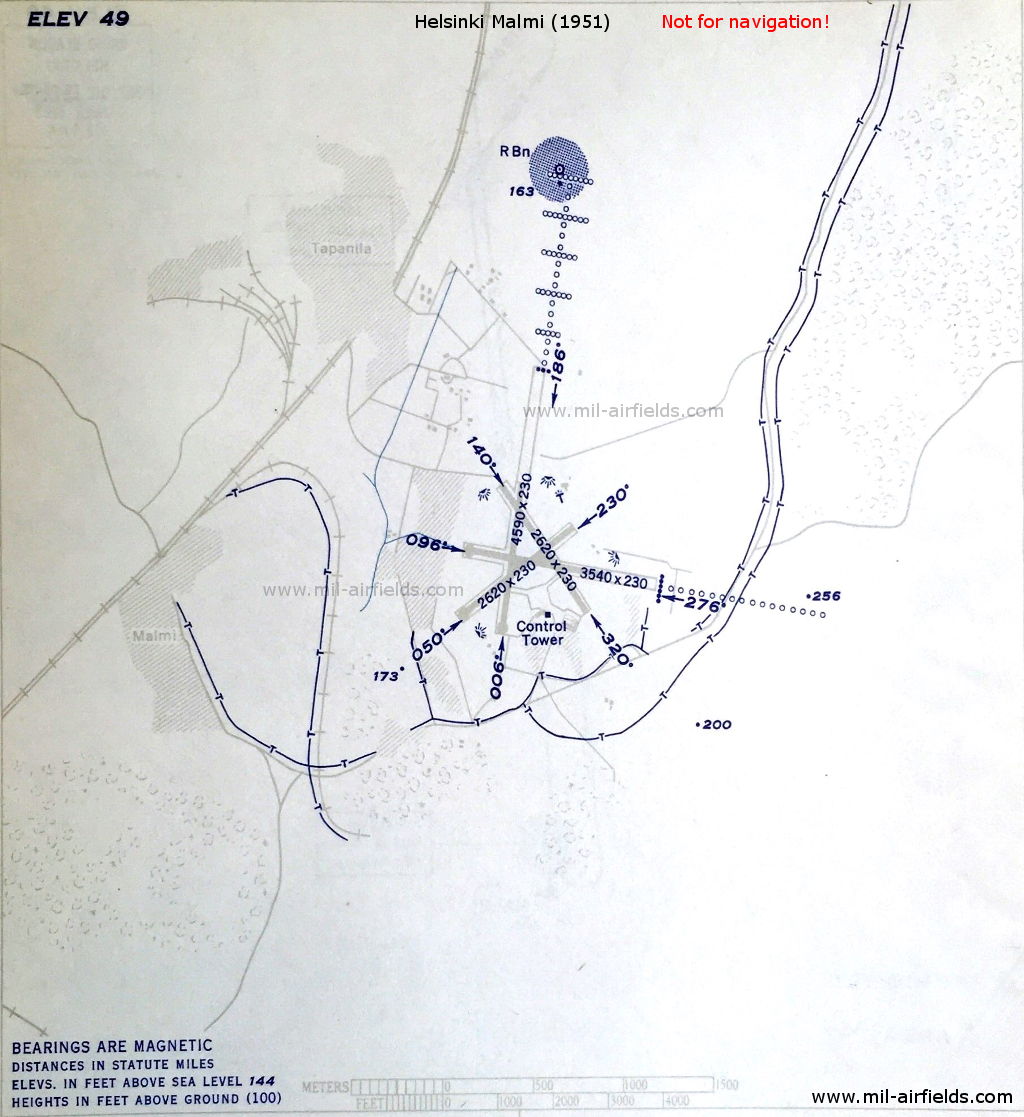
Helsinki Malmi Airfield, 1951 - At the beginning of the approach lights in the north is the NDB "M". (Source: DoD)
Helsinki: Vantaa Airport (Helsinki-Vantaan lentoasema)
Runway 22:
Helsinki/Vantaa: ILS 22
HK, 110.3 MHz
HK, 110.3 MHz
To runway 22 (223°).
Helsinki/Vantaa: Korso LOM
223°/3.94 NM to THR 22
223°/3.94 NM to THR 22
See Korso LOM.
Helsinki/Vantaa: MM 22
223°/1.09 NM to THR 22
Dots Dashes, 75 MHz
223°/1.09 NM to THR 22
Dots Dashes, 75 MHz
Helsinki/Vantaa: Locator
N6020 E02459 (approx.), 223°/0.66 NM to field Google Maps
H, 414.5 kHz
N6020 E02459 (approx.), 223°/0.66 NM to field Google Maps
H, 414.5 kHz
Also listed with frequencies 314.5 and 375 kHz.
Helsinki/Vantaa: IM 22
223°/0.29 NM to THR 22
Dots, 75 MHz
223°/0.29 NM to THR 22
Dots, 75 MHz
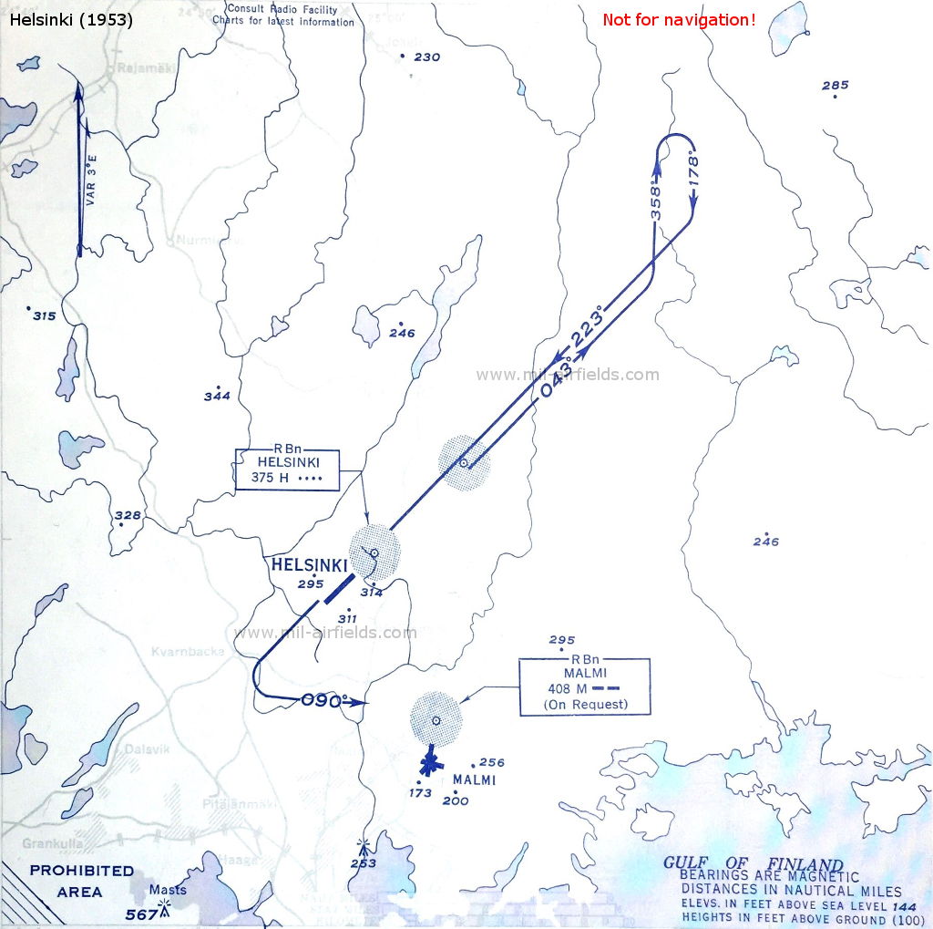
NDB approach to Helsinki Vantaa Airport in 1953 - The radio beacon Korso "OJZ" (approx. in the center of the picture, here not designated) was located at the intersection of the approach courses for Vantaa and Malmi. (Source: DoD)

Helsinki Vantaa Airport, 1953 - At this time, the airport has only one runway, the second one is under construction. (Source: DoD)
Ivalo: Airfield (Ivalon lentoasema, Avvila girdingieddi)
Järvenpää: NDB
N6031 E02506 (approx.), 182°/15.7 NM to Helsinki Malmi Google Maps
OJA, 396 kHz
N6031 E02506 (approx.), 182°/15.7 NM to Helsinki Malmi Google Maps
OJA, 396 kHz
Operated on request.
For historical information only, do not use for navigation or aviation purposes!
Joensuu: Airfield (Joensuun lentoasema)
Joensuu/Onttola: Locator
N6240 E02938 (approx.), 283°/0.86 NM to field Google Maps
F, 340 kHz
N6240 E02938 (approx.), 283°/0.86 NM to field Google Maps
F, 340 kHz
Operated on request.
Jungsund: NDB
N6311 E02140 (approx.), 161°/8.1 NM to Vaasa Google Maps
OJV, 357 kHz
N6311 E02140 (approx.), 161°/8.1 NM to Vaasa Google Maps
OJV, 357 kHz
(Korsholm). Operated on request.
Jyväskylä: Air Base (Jyvaskyla, Luonetjärvi, Tikkakoski, Jyväskylän lentoasema)
Jyväskylä/Luonetjarvi: Locator
N6224 E02540 (approx.), 307°/0.73 NM to field Google Maps
L, 407 kHz
N6224 E02540 (approx.), 307°/0.73 NM to field Google Maps
L, 407 kHz
Operated on request.
Kauhava: Airfield (Kauhavan lentokenttä)
Kemi: Airfield (Tornio, Kemi-Tornion lentoasema)
Runway 19:
Kemi: SBA 19
33.3 MHz
33.3 MHz
To runway 19 (186°)
Kemi: OM 19
186°/1.84 NM to THR 19
Dashes, 38 MHz
186°/1.84 NM to THR 19
Dashes, 38 MHz
Kemi: IM 19
186°/0.17 NM to THR 19
Dots, 38 MHz
186°/0.17 NM to THR 19
Dots, 38 MHz
Korso: LOM
N6022 E02504 (approx.), 223°/3.94 NM to THR 22 Google Maps
Locator: OJZ, 387 kHz
N6022 E02504 (approx.), 223°/3.94 NM to THR 22 Google Maps
Locator: OJZ, 387 kHz
Korso LOM was located at the intersection of the approach courses for Helsinki Vantaa 223° and Helsinki Malmi 183°.
Kuopio: Air Base (Rissala)
Kuopio/Rissala: Locator
N6301 E02748 (approx.), 332°/0.77 NM to field Google Maps
K, 310 kHz
N6301 E02748 (approx.), 332°/0.77 NM to field Google Maps
K, 310 kHz
Operated on request.
For historical information only, do not use for navigation or aviation purposes!
Kymi: Airfield (Kotka, Kymin lentokenttä)
Mariehamn: Airfield (Maarianhaminan lentoasema)
Mariehamn: Locator
N6008 E01955 (approx.), 202°/0.76 NM to field Google Maps
S, 376 kHz
N6008 E01955 (approx.), 202°/0.76 NM to field Google Maps
S, 376 kHz
Operated on request.
Mariehamn: NDB
N6007 E01957 (approx.), 286°/1.67 NM to field Google Maps
OJD, 392 kHz
N6007 E01957 (approx.), 286°/1.67 NM to field Google Maps
OJD, 392 kHz
Operated on aerodrome times from 0500 to 2000 weekdays.
Oulu: Air Base (Oulun lentoasema)
Runway 12:
Pori: Airfield (Bjorneborg, Porin lentoasema)
Pori: Locator
N6128 E02148 (approx.), 124°/0.56 NM to field Google Maps
P, 318 kHz
N6128 E02148 (approx.), 124°/0.56 NM to field Google Maps
P, 318 kHz
Operated on request.
Rovaniemi: Airfield
Rovaniemi: Locator
N6634 E02550 (approx.), 221°/0.6 NM to field Google Maps
R, 414 kHz
N6634 E02550 (approx.), 221°/0.6 NM to field Google Maps
R, 414 kHz
Operated on request.
Rovaniemi: NDB
N6632 E02548 (approx.), 018°/1.4 NM to field Google Maps
OJN, 394 kHz
N6632 E02548 (approx.), 018°/1.4 NM to field Google Maps
OJN, 394 kHz
Operated on request.
For historical information only, do not use for navigation or aviation purposes!
Sodankylä: NDB
N6722 E02639 (approx.) Google Maps
SO, 364 kHz
N6722 E02639 (approx.) Google Maps
SO, 364 kHz
Operated on aerodrome times from 1000 to 1430.
Tampere: Härmälä Airport (Tampere-Härmälän lentoasema)
Tampere: NDB
N6129 E02345 (approx.), 210°/1.0 NM to field Google Maps
OIT, 328 kHz
N6129 E02345 (approx.), 210°/1.0 NM to field Google Maps
OIT, 328 kHz
Operated on request.
Turku: Artukainen Airport
Turku: Locator
260°/0.8 NM to field
A, 355 kHz
260°/0.8 NM to field
A, 355 kHz
Turku: Locator
080°/1.04 NM to field
L, 380 kHz
080°/1.04 NM to field
L, 380 kHz
Turku: Locator
260°/4.1 NM to field
TU, 410 kHz
260°/4.1 NM to field
TU, 410 kHz
Turku: NDB
OJY, 361 kHz
OJY, 361 kHz
Runway 08:
Turku: ILS 08
TU, 109.5 MHz
TU, 109.5 MHz
To runway 08 (080°)
Turku: OM 08
080°/4.1 NM to THR 08
Dashes, 75 MHz
080°/4.1 NM to THR 08
Dashes, 75 MHz
Turku: MM 08
080°/1.29 NM to THR 08
Dots Dashes, 75 MHz
080°/1.29 NM to THR 08
Dots Dashes, 75 MHz
Turku: IM 08
080°/0.4 NM to THR 08
Dots, 75 MHz
080°/0.4 NM to THR 08
Dots, 75 MHz
Utti: Air Base (Utin lentokenttä)
Vaasa: Airfield
Vaasa: Locator
N6303 E02146 (approx.), 161°/0.56 NM to field Google Maps
W, 406 kHz
N6303 E02146 (approx.), 161°/0.56 NM to field Google Maps
W, 406 kHz
Operated on request.
For historical information only, do not use for navigation or aviation purposes!
Recommended
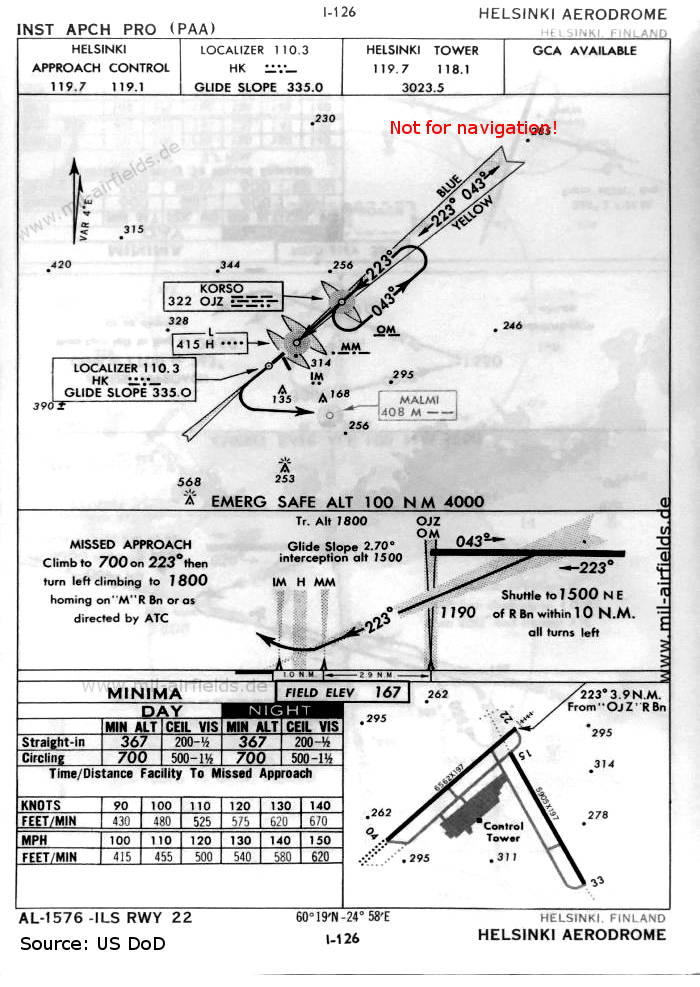
Image credits are shown on the respective target page, click on the preview to open it.