For historical information only, do not use for navigation or aviation purposes!
| Coordinates | N515944 E0125854 (WGS84) Google Maps |
| Elevation | 328 ft |
| Federal state | Brandenburg |
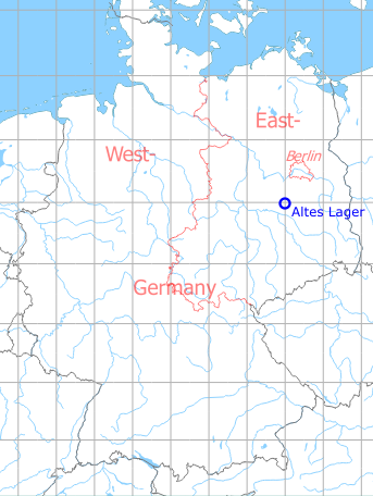
Germany during the Cold War Map
The history of the Cold War airfields: Altes Lager
During World War II
Use
Luftwaffe airfield.
Situation
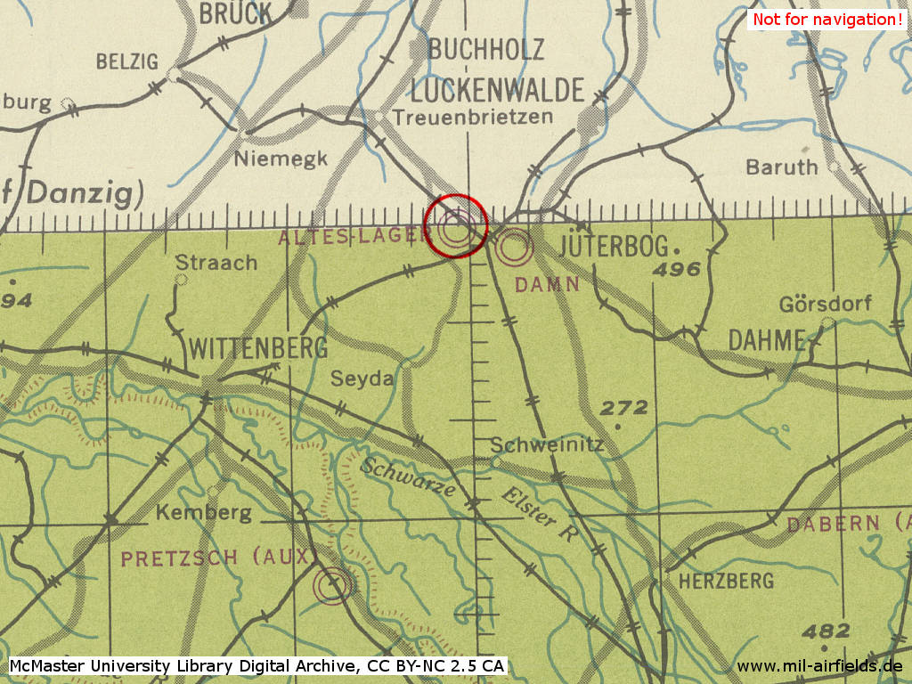
Altes Lager Air Base in World War II on a US map from 194x
Source: McMaster University Library Digital Archive, Lizenz: Creative Commons Attribution-NonCommercial 2.5 CC BY-NC 2.5 CA
During the Cold War
Use
Soviet forces airbase.
In the 1950s
Units
1954
- Soviet fighter regiment (P. O. Box of the technical unit: 30 136)
- Soviet fighter regiment (P. O. Box of the technical unit: 29 708)
- A total of 38 MiG-15/MiG-15U were counted at the airfield
Source: BND/Bundesarchiv B 206/3033
(For the P. O. Box numbers the digits 3 and 5 may be confused, because they are difficult to distinguish in the source document)
(For the P. O. Box numbers the digits 3 and 5 may be confused, because they are difficult to distinguish in the source document)
In the 1960s
Overview
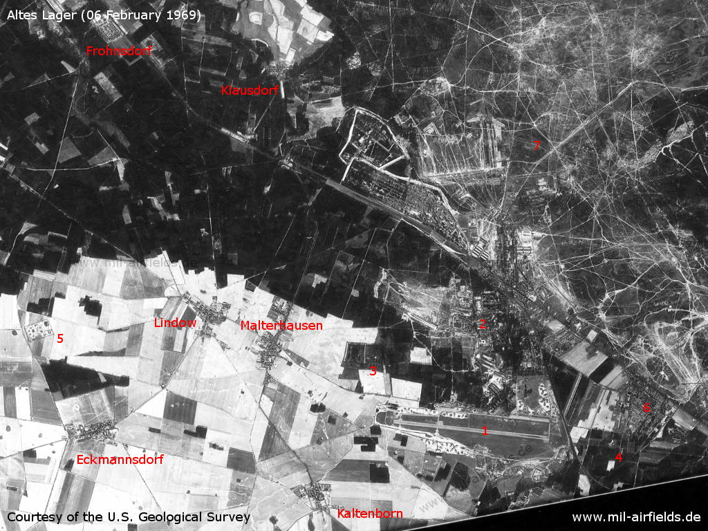
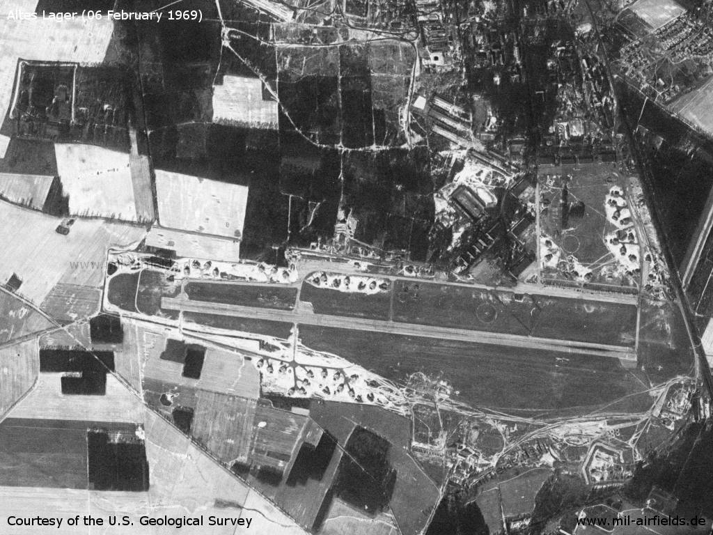
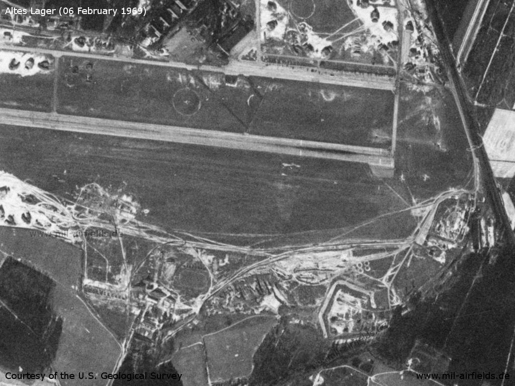
Altes Lager Air Base on a US satellite image from 06 February 1969 - 1: airfield; 2: barracks; 3: storage area; 4: inner radio beacon east; 5: SAM site; 6: Neues Lager barracks; 7: Forst Zinna military training area. Places: Eckmannsdorf, Frohnsdorf, Kaltenborn, Klausdorf, Lindow, Malterhausen.
Source: U.S. Geological Survey
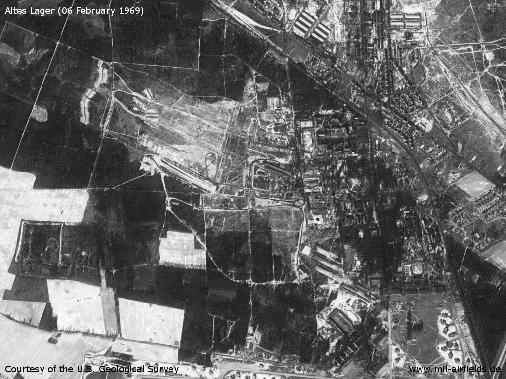
Barracks in the north
Source: U.S. Geological Survey
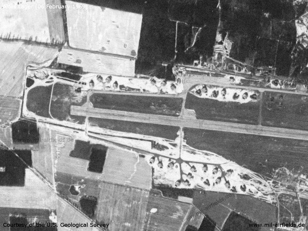
The airfield has recently been equipped with concreted aircraft shelters.
Source: U.S. Geological Survey
Western part
Source: U.S. Geological Survey
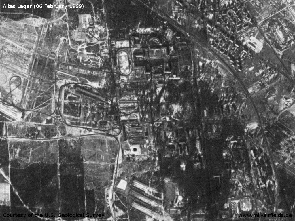
Enlargement of the Soviet barracks - Until 1945: Höhere Fliegertechnische Schule
Source: U.S. Geological Survey
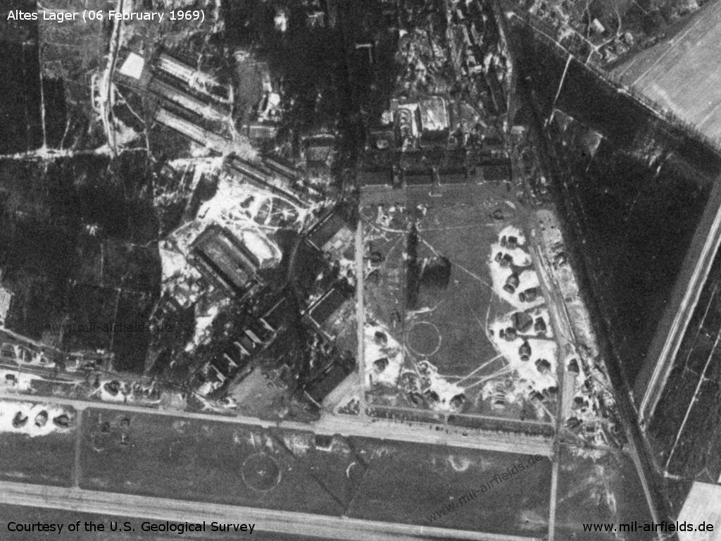
Northeastern part - The loop with the hangars in the north and the three hangars in the west is characteristic.
Source: U.S. Geological Survey
Southeastern part - The railway line to Treuenbrietzen runs directly past the eastern edge of the field.
Source: U.S. Geological Survey
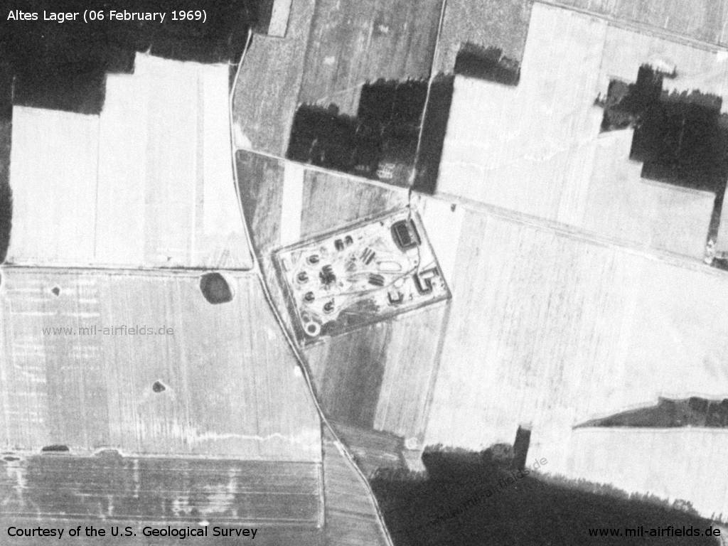
Surface-to-air missile (SAM) site near Eckmannsdorf / Lindow
Source: U.S. Geological Survey
Communication
The russian call sign for the airfield was:
GABARITNIJ (observed mid of the 1960s)
GABARITNIJ (observed mid of the 1960s)
History
- 1966
Observation by the US Military Liaison Mission: The Jueterbog regiment has been equipped with aircraft MiG-21 FISHBED F, like the regiments in Pütnitz and possibly Altenburg. (Source: USMLM 1966) - May 1966
Observation by the US Military Liaison Mission: "In May the FISHBED air defense regiment at Jueterbog twice deployed to the Reinsdorf grass strip; this was the first sighting of FISHBED F aircraft operating on a natural surface and added measurably to our knowledge of the aircraft's capabilities." (Source: USMLM 1966) - August 1969
Observation by the US Military Liaison Mission: Unmarked MiG-21PF (Source: USMLM 1969) - 14 October 1969
Observation by the US Military Liaison Mission: Powerful flying program (Source: USMLM 1969)
In the 1970s
Situation
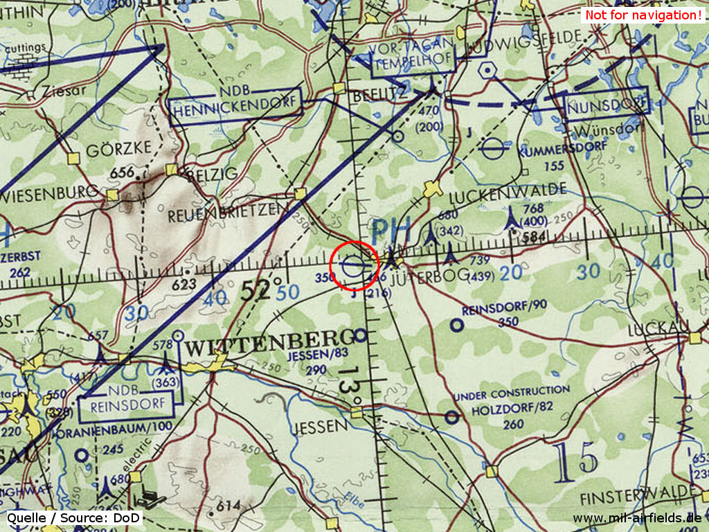
Altes Lager Air Base on a map of the US Department of Defense from 1972 - The blue lines mark the allied air corridors from and to Berlin
Source: ONC E-2 (1972), Perry-Castañeda Library Map Collection, University of Texas at Austin
Overview
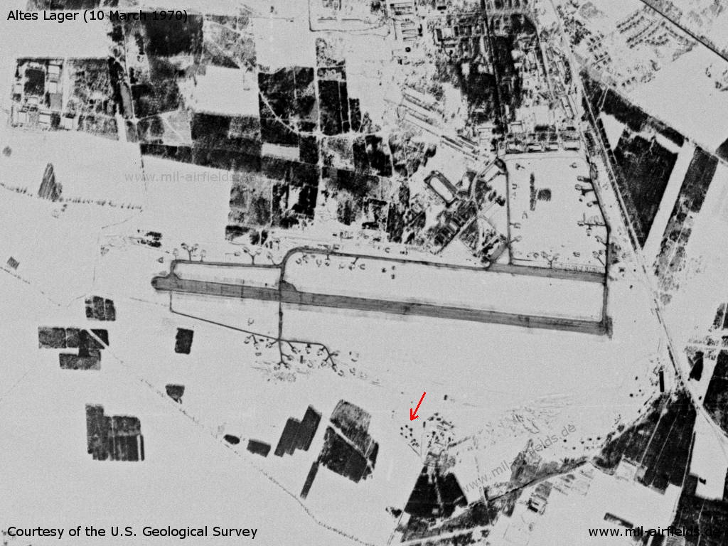
On 10 March 1970 the area is covered with snow. - This makes the hexagonal structure clearly visible (red arrow), which is probably an air defense site.
Source: U.S. Geological Survey
Radio beacons
Data for the 1970s:
- LOM 28: 313 "BM"
- LMM 28: 645 "B"
- LOM 10: 313 "LG"
- LMM 10: 645 "L"
In the 1980s and early 1990s
Situation
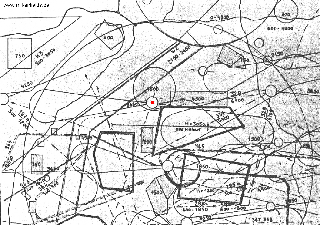
Situation of Altes Lager air base in the 1980s - This map from the former East German National People's Army shows the military use of the airspace southwest of Berlin. As a topographic feature the autobahns are marked. K3 marks the southern allied corridor, which opens into the circular Berlin Control Zone at the top, of which only the lower part is visible. Partially parallel to the southern corridor is the much smaller East German airway W2, which begins at the Schönefeld Terminal Area (TMA) and breaks to the south at a point southwest of Wittenberg. The small circles mark airfields, Altes Lager has a red point. The irregular loop surrounding an airfield is the respective approach system. The large circle is the 60km radius around the Holzdorf airfield. In addition, some flight zones and restricted areas are listed.
Overview
The map shows the location of the hangars, radio beacons, radar systems and the course of the connecting railway.
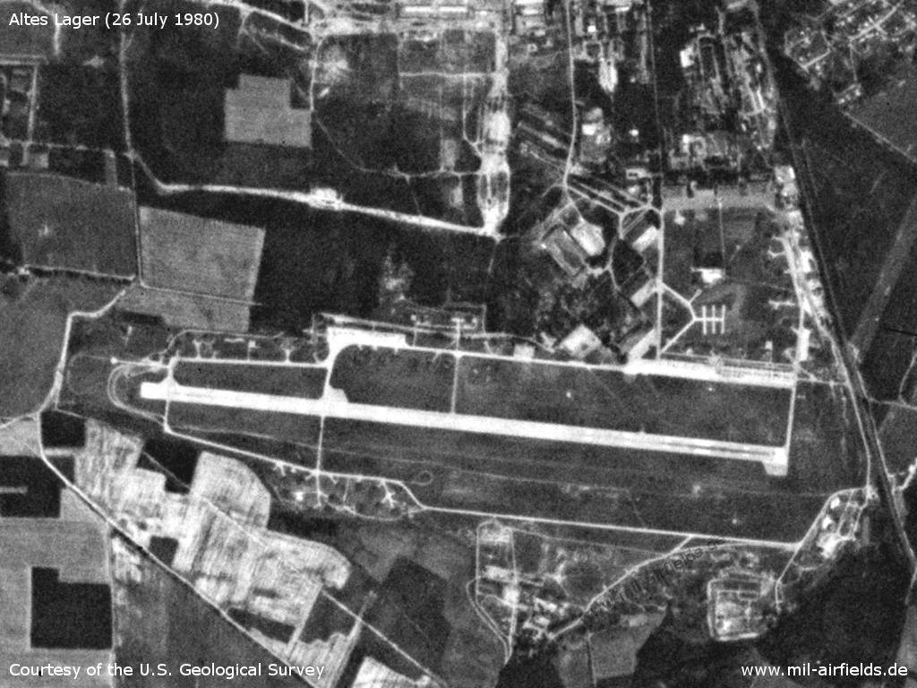
The airfield on 26 July 1980 - In the meantime a parking place for 6 helicopters has been built within the hangar loop.
Source: U.S. Geological Survey
Runways
- 10/28: 2600 m
Radio beacons
Für die 1980er Jahre liegen mir nur einzelne Informationen vor. Für 1989 wird im "Verzeichnis 012" für Altes Lager ein Zonenfunkfeuer auf der Frequenz 390 kHz mit der Kennung "RK" genannt. Gemäß einer anderen Quelle, die vermutlich aus den 1980er Jahren stammt, arbeitete auf 390 kHz das Nahfunkfeuer "B". Das dazu gehörende Fernfunkfeuer hatte die Frequenz 313 kHz und die Kennung "BM"
Communication
The russian call signs for the airfield was
LEXIJA (198x-199x) (means "Lecture", original notation in Cyrillic: ЛЕКЦИЯ).
LEXIJA (198x-199x) (means "Lecture", original notation in Cyrillic: ЛЕКЦИЯ).
On a map of meterological station from the tower at Sperenberg airfield from the beginnning of the 1990s, the Name KNIGA was noted for Altes Lager (=Name of Met office?).
Standard training routes
"Flüge der LSK/LV der NVA und der LSK der GSSD im Rahmen der Gefechtsausbildung sind entsprechend der Grafik der Flugtage / -nächte auf der Grundlage der "Hauptflugregeln zum Fliegen im Luftraum der Deutschen Demokratischen Republik" auf Standardflugstrecken in den dazu festgelegten Flughöhen durchzuführen. ..." (Source: "Verzeichnis der Standardflugstrecken der LSK/LV der NVA und der LSK der GSSD")
223 Altes Lager, Gräfenhainichen, LK, Schönewalde, Altes Lager
Altitude: 600 - 1850 m (in coordination with VHZ)
Interception leg: Zahna, Burgkemnitz, Prettin, Schweinitz
Altitude: 600 - 1850 m (in coordination with VHZ)
Interception leg: Zahna, Burgkemnitz, Prettin, Schweinitz
224 Altes Lager, Nauen, Wolmirstedt, Altes Lager
Altitude: 4900, 5500 m
Interception legt: Buschow, Colbitz
Altitude: 4900, 5500 m
Interception legt: Buschow, Colbitz
225 Altes Lager, Öhna, Golssen, Baruth, Schießplatz Heidehof range, Markendorf, Altes Lager
Altitude: 300 - 600 m
Altitude: 300 - 600 m
227 Altes Lager, Wittenberg, Trossin, Schildau, Schießplatz Belgern range, Herzberg, Altes Lager
Altitude: to the range 300 - 1200 m, return 1200 - 1850 m (climb overhead range)
Altitude: to the range 300 - 1200 m, return 1200 - 1850 m (climb overhead range)
228 Altes Lager, Raben, Sömmerda, Senftenberg, Altes Lager
Altitude: 7900, 8550, 11900 - 18000 m
Descend: Senftenberg, abeam Finsterwalde maximum altitude 7900 m
Interception leg: Coswig, Halle, Traverse Leipzig, Lauchhammer
Altitude: 7900, 8550, 11900 - 18000 m
Descend: Senftenberg, abeam Finsterwalde maximum altitude 7900 m
Interception leg: Coswig, Halle, Traverse Leipzig, Lauchhammer
543 Altes Lager, Treuenbrietzen, Niemegk, Cobbelsdorf, Zahna, Öhna, Altes Lager
Altitute: 100 - 300 m
Altitute: 100 - 300 m
Real property
Anti-aircraft missile site 5.6 km west of the airfield near Lindow.
The Treuenbrietzen-Jüterbog railway line runs directly on the eastern edge of the field. Due to the increasing problem of "concrete cancer" in the Deutsche Reichsbahn network, transit trains from Berlin to the Federal Republic of Germany were also routed via this line in the 1980s. From these trains, one had a good view of the radar equipment on the eastern edge and of the runway.
The US replica in Nevada
It seems that the Jüterbog / Altes Lager airfield has been copied and build as a target airfield in Nevada / USA. In the western part of the Nellis Airforce Range is the "Tolicha Peak Electronic Combat Range" (TPECR). About 7 km northwest of the TPECR is an airfield target (N3722 W11650). According to a document from the internet, this airfield is named as "Eastman Airfield Target" or "Target 76-14".
According to other sources in the internet, the airfield is also named "Korean Airfield". But it has strong similarities to "Jüterbog / Altes Lager". It has the northeastern taxiway loop which is characteristical for "Altes Lager". The strongest similarity are the three ramps in front of hangars on the western side of the loop. The other taxiways have at least a similar layout in comparison to the original airfield. The runway of the copy is about 400 m shorter.
About 2.5 km west-northwest of the copy there is an object which might be a copy of the SAM site, located 5.6 km west-northwest of the original airfield. And there is a SA-2 SAM site located 5.6 km to the northwest of the copy.
Learn more about this copy of the East German Air Base:
Range 76: Altes Lager Air Base as Target.
Range 76: Altes Lager Air Base as Target.
Today
Use
Closed.
Links
- http://www.history.hqusareur.army.mil/uslmannual.htm (offline): USMLM Unit History 1969 - Notice about unmarked MiG-21PF in Jüterbog in August 1969; Notice about a flying program at 14OCT1969.
- http://www.history.hqusareur.army.mil/uslmannual.htm (offline): USMLM Unit History 1972 - The wing has a mix of MiG-21PF and MiG-21PFM; deployment to Reinsdorf in July (observed on the 10th., 11th und 12th June) (with two pictures from Reinsdorf); At the end of 1972, the anti-aircraft missile site has 7 MERCURY GRASS.
- http://www.history.hqusareur.army.mil/uslmannual.htm (offline): USMLM Unit History 1973 - Notice about introduction of MiG-21bis FISHBED L at Jüterbog. First sighting on the 17th April 1973. The most of the MiG-21PF returned to the Soviet Union. The MiG-21PFM left for Alt Lönnewitz/Falkenberg Air Base.
- http://www.history.hqusareur.army.mil/uslmannual.htm (offline): USMLM Unit History 1975 - Deployment of MiG-21bis from Jüterbog to Reinsdorf. Picture of a MiG-21bis from Jüterbog.
- http://www.history.hqusareur.army.mil/uslmannual.htm (offline): USMLM Unit History 1977 - First photographic evidence about using AA-8 APHID with MiG-21bis.
- http://www.history.hqusareur.army.mil/uslmannual.htm (offline): USMLM Unit History 1984 - First sighting of MiG-23MLD FLOGGER K in Jüterbog on the 13th March 1984; Inventory in may 1984: 12 MiG-23MLD FLOGGER K and 24 MiG-23ML FLOGGER G
- http://www.sachsenschiene.net/bunker/flp/flp_33.ht... - Sachsenbunker
- http://www.henrik-schulze.de/ - Garnisongeschichte Jüterbog Comprehensive history of the Juterbog garrison. With many pictures.
- http://www.hl-barbara.de/ - Garnisongeschichte Jüterbog St. Barbara e.V.
Bibliography
- United States Military Liaison MissionUnited States Military Liaison Mission: "Unit History 1966Unit History 1966"
- Freundt, Lutz: "Sowjetische Fliegerkräfte in Deutschland 1945-1994, Band 2" Freundt Eigenverlag, Diepholz 1999 - Detailled description, map, aerial pictures and photos.
- Freundt, Lutz: "Sowjetische Fliegerkräfte in Deutschland 1945-1994, Band 3" Edition Freundt Eigenverlag, Diepholz 1999 - Pictures
- Freundt, Lutz: "Sowjetische Fliegerkräfte in Deutschland 1945-1994, Band 4" Edition Freundt Eigenverlag, Diepholz 2000 - Supplement
- Schulze, Henrik: "Geschichte der Garnison Jüterbog 1890-1994 - Jammerbock" Biblio-Verlag, 2000
Related topics
Airfields in the vicinity
- 110°/6km Jüterbog: Damm Airfield (Jüterbog Damm Air Base)
- 125°/18km Reinsdorf: Airfield (Werbig, Аэродром Вербиг)
- 055°/27km Sperenberg: Air Base (Kummersdorf, Аэродром Шперенберг)
- 308°/27km Lüsse: Airfield (Bad Belzig)
- 153°/28km Holzdorf: Air Base
- 338°/28km Neuendorf (Brück): Helipad 1030 (HSLP / HLP 1030)
- 236°/29km Wittenberg: Airfield (Аэродром Виттенберг, Lutherstadt Wittenberg)
Categories
Military Airfields GermanyMilitary Airfields in former East GermanyAirfields of the Soviet Forces in GermanyRecommended
Image credits are shown on the respective target page, click on the preview to open it.
 Follow mil-airfields on Facebook