Seville San Pablo Airport
Historical approach and aerodrome charts
Aeropuerto de Sevilla-San Pablo - Cartas de aproximación históricos
For historical information only, do not use for navigation or aviation purposes!
| Coordinates | N372505 W0055335 (WGS84) Google Maps |
Airport
Region: Andalusia / Andalucía
Location Indicator: LEZL
In the 1950s

Airport map (October 1950)
One runway is 6,500 feet (1,981 meters) long, the other 4,920 feet (1,500 meters) long. The east-west runway is under construction.
(Source: US DoD)
One runway is 6,500 feet (1,981 meters) long, the other 4,920 feet (1,500 meters) long. The east-west runway is under construction.
(Source: US DoD)
In the 1960s
NDB approach (October 1960)
There are two runways - 05/23: length 2150 m, width 50 m (7054 feet x 164 feet), 09/27: length 2350 m, width 80 m (7709 feet x 262 feet).
(Source: US DoD)
There are two runways - 05/23: length 2150 m, width 50 m (7054 feet x 164 feet), 09/27: length 2350 m, width 80 m (7709 feet x 262 feet).
(Source: US DoD)
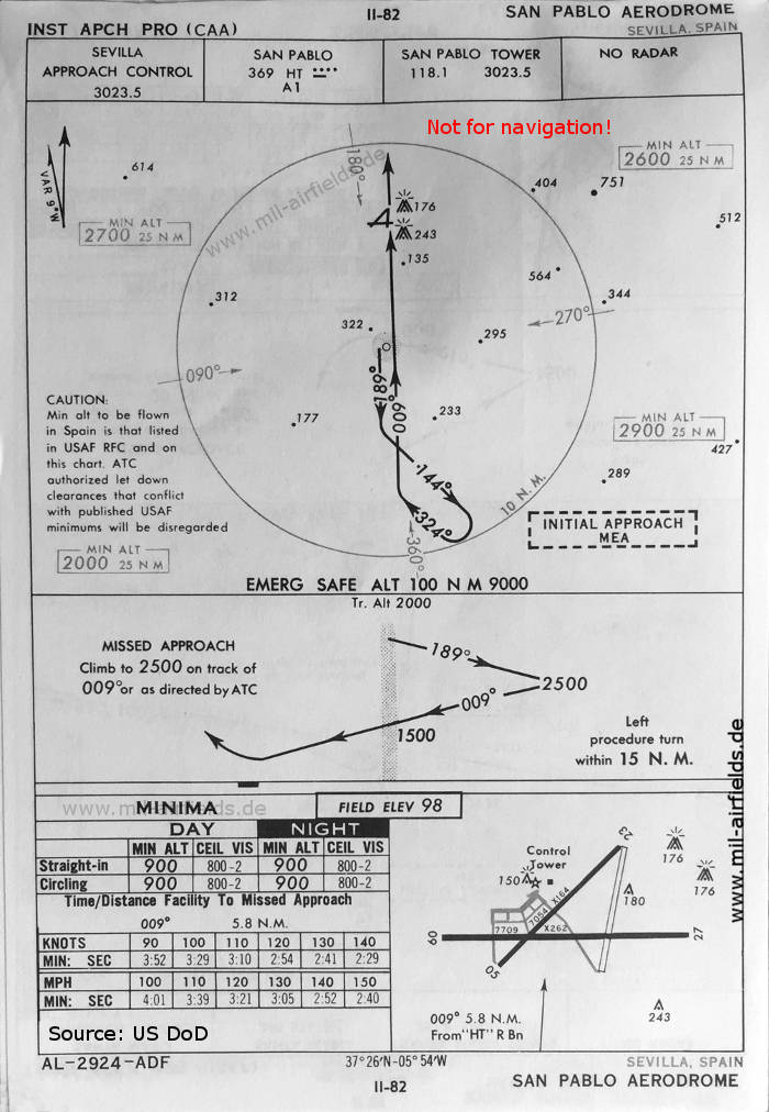
NDB approach runway 27 (May 1966)
Now the runways are given as - 05/23: length 1948 m, width 50 m (6391 feet x 164 feet), 09/27: length 3360 m, width 60 m (11024 feet x 197 feet).
(Source: US DoD)
Now the runways are given as - 05/23: length 1948 m, width 50 m (6391 feet x 164 feet), 09/27: length 3360 m, width 60 m (11024 feet x 197 feet).
(Source: US DoD)
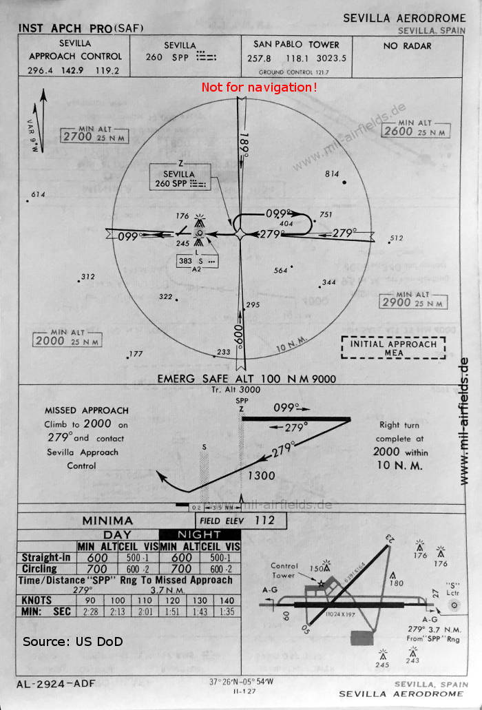
VOR approach runway 27 (May 1966)
(Source: US DoD)
(Source: US DoD)
Index to the objects shown on the maps
Radio beacons / Radiofaro:
- San Pablo NDB "HT"
- Sevilla Range "SPP", Locator "S", VOR "SPV"
Air traffic control / Controllo del traffico aereo:
- Sevilla Approach Control
- San Pablo Tower, Ground Control
Source for all maps, if not marked otherwise: US Department of Defense (US DoD)
Recommended
Image credits are shown on the respective target page, click on the preview to open it.
 mil-airfields.de at Facebook