For historical information only, do not use for navigation or aviation purposes!
| Coordinates | N494148 E0180642 (WGS84) Google Maps |
| Elevation | 844 ft |
| Location indicator | LKMT |
| Airfield Id | Punkt 710 |
The history of the Cold War airfields: Mošnov
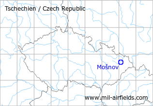
Location of airfield
17 km southwest of Ostrava.
During the Cold War
Use
Air base.
Radio beacons
Data for the year 1990:
- LOM: 458 "NR / RN"
- LMM: 221 "N / R"
Radio communication
The radio call sign of the airfield was "NEKTAR" (198x).
According to western signals intelligence (SIGINT), the airfield was also called "Navigacni Punkt 710" by the Czechoslovak Air Force.
Units
82 SSLT: L-39ZA, MiG-21MF, UM (1990); 1 SMDLP: An-12, An-26, L-410M, T, Mi-17 (1990)
Installations
Dispersal area in the northeast of the field with large parking pads.
Today
Use
Ostrava regional airport.
Airfields in the vicinity
- 354°/26km Zábřeh: Airfield (Letiště Zábřeh)
 Follow mil-airfields on Facebook