Radio beacons Berlin in 1958/59
Navaids: NDB, Range, ILS
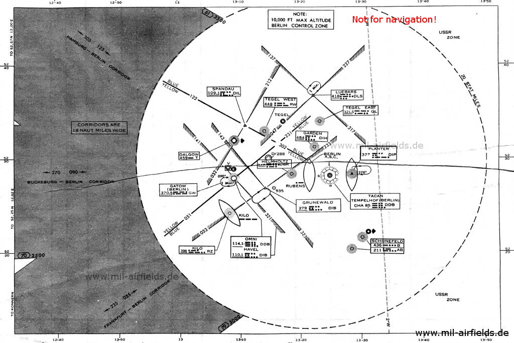
The following list contains the aeronautical radio beacons that were active in Berlin in 1958/59. All information is outdated and may not be used for navigational purposes.
The situation in Berlin was characterised by the division into four sectors and by the special access with the three air corridors and the Berlin control zone. Western Allied aircraft thus had a relatively wide airspace at their disposal. However, they had to reckon with hostilities of the Soviets up to the shooting down of the aircraft even at minimal deviations (but even without deviations there were repeated arbitrary attacks by Soviet aircraft). Precise navigation was therefore essential for survival, but the radio beacons necessary for this were limited to the area of the three western sectors.
At the same time, new navigation systems were introduced. And the British used different technology than the Americans. These factors led to a wide range of types that were used in limited spaces at the time:
- Non-directional beacon (NDB)
- Range
- Visual-Aural Range
- VHF Omnidirectional Radio Range (VOR)
- Tactical Air Naviation (TACAN)
- Eureka
- BABS
- Instrument Landing System (ILS)
Radio beacons 1959
Explanations
![]()
Abbreviations
| approx. | approximately | |
| civ | civil | civil operator |
| GP | Glide path | Glide path transmitter |
| ILS | Instrument Landing System | (Approach and landing aid) |
| IM | Inner Marker | Marker beacon just in front the runway |
| kHz | Kilohertz | (Unit for frequency) |
| L | Locator | Non-directional beacon for the approach |
| LLZ | Localizer | Localizer transmitter |
| LMM | Locator Middle Marker | Combination of Middle Marker and Locator |
| LOM | Locator Outer Marker | Combination of Outer Marker and Locator |
| m | Meter | (Unit for length) |
| MHz | Megahertz | (Unit for frequency) |
| mil | military | military operator |
| MM | Middle Marker | Marker beacon |
| NDB | Non-directional beacon | Non-directional beacon on long or medium waves |
| NM | Nautical Miles | (Unit for length) |
| OM | Outer Marker | Marker beacon |
| PRMG | ПРМГ Посадочная радиомаячная группа | Soviet / russian military instrument landing system |
| RSBN | РСБН Rадиотехническая система ближней навигации | Soviet / russian military radio navigation system |
| SBA | Standard Beam Approach | Approach system, Lorenz system, predecessor of the ILS |
| THR | Threshold | Runway threshold (most often with number of runway) |
| transf. | transformed | Coordinates were converted from a different reference system, therefore there may be deviations. |
| VAR | Visual-Aural Rnange | |
| VOR | VHF Omnidirectional Radio Range | |
| W | Watt | (Unit for power) |
| WGS84 | World Geodetic System 1984 | (geospatial reference system, GPS coordinates) |
Operator
| RAF | Royal Air Force |
| USAFE | US Air Force Europe |
| USBER | US Mission Berlin |
Directory
Berlin: RAF Gatow Airfield (Kladow)
GW, 233T/218R MHz
N522756 E0130920 (WGS84, transf.) Google Maps
GW, 370.5 kHz
Berlin: Tegel Airport
N523307 E0131351 (WGS84, transf.), 083°/1.86 NM to THR 08 Google Maps
RW, 448 kHz, 50 W
N523359 E0132242 (WGS84, transf.), 263°/2.72 NM to THR 26 Google Maps
GL, 321.5 kHz, 50 W
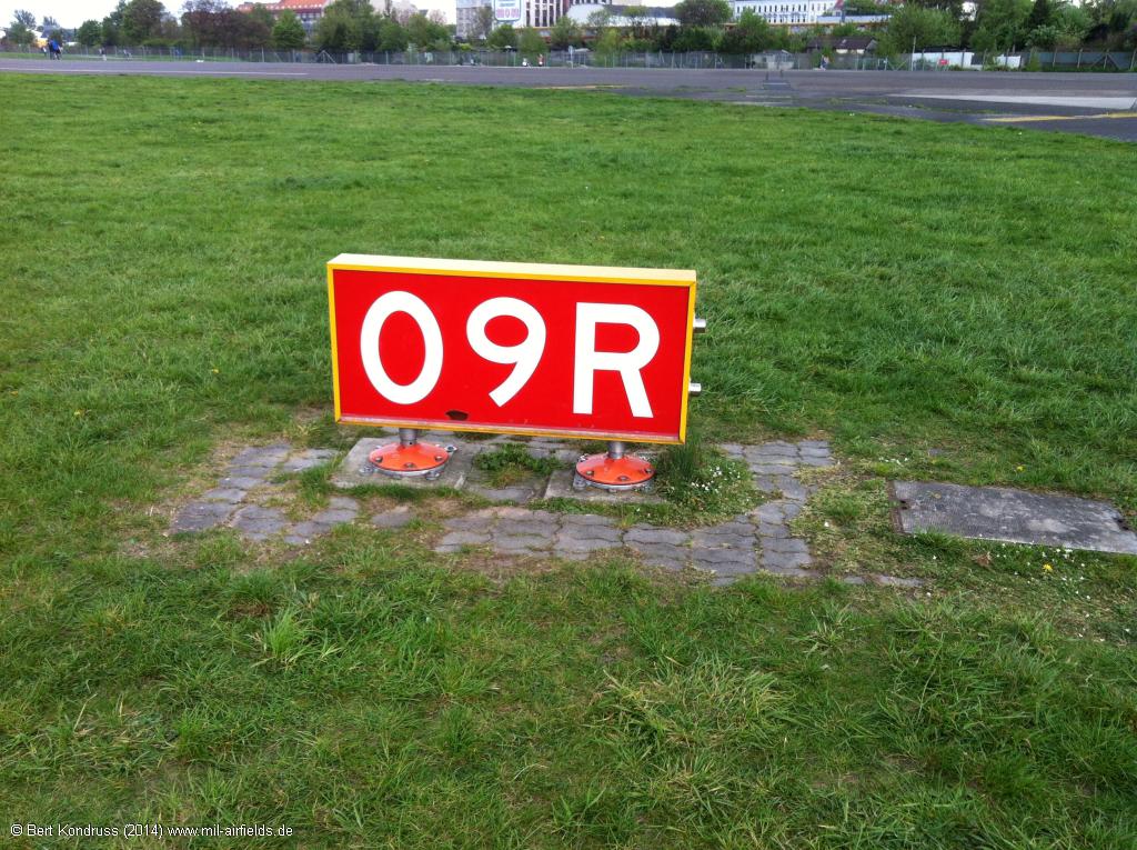
Berlin: Tempelhof Airport (Berlin Tempelhof Central Airport TCA)
DDB, CH 85
N522816 E0132508 (WGS84, transf.) Google Maps
DBR, 110.9
N522810 E0132040 (WGS84, transf.), 090°/1.8 NM to THR 09R Google Maps
dot-dash, 75
N522805 E0131741 (WGS84, transf.), 090°/3.6 NM to THR 09R Google Maps
DBR, 347 kHz, 25 W
N522813 E0132322 (WGS84, transf.) Google Maps
DLB, 109.5
N522814 E0132446 (WGS84, transf.) Google Maps
332.6 MHz
N522819 E0132809 (WGS84, transf.), 270°/2.0 NM to THR 27L Google Maps
NDB: DIP, 327 kHz, 50 W
Outer Marker: Dashes, 75 MHz
N522821 E0132538 (WGS84, transf.), 270°/0.37 NM to THR 27L Google Maps
75 MHz
N523132 E0132158 (WGS84, transf.), 159°/3.4 NM to Berlin Tempelhof ARP Google Maps
DIH, 398 kHz
N522730 E0131417 (WGS84, transf.), 084°/5.6 NM to THR 09R Google Maps
Range: DIB, 279 kHz
Z Marker: 75 MHz
N522749 E0130836 (WGS84, transf.), 091°/9.8 NM to Berlin Tempelhof Google Maps
DIB, 110.1
N522740 E0130834 (WGS84, transf.), 089°/9.9 NM to Berlin Tempelhof Google Maps
DDB, 114.1 MHz
N522416 E0130823 (WGS84, transf.) Google Maps
NDB: RZ, 398 kHz, 25 W
Fan Marker: 3 Dashes, 75 MHz
N523649 E0132148 (WGS84, transf.), 170°/8.9 NM to Berlin Tempelhof Google Maps
DLS, 418, 100 W
Berlin: Schönefeld Airport (Zentralflughafen Berlin-Schönefeld, SXF)
N522426 E0133411 (WGS84, approx.) Google Maps
Locator: AB, 211 kHz
Outer Marker: 75 MHz
N522327 E0133218 (WGS84) Google Maps
Locator: A, 436 kHz
Middle Marker: 75 MHz
N523336 E0131001 (WGS84, transf.), 121°/10.4 NM to Berlin-Tempelhof Google Maps
DIL, 109.1