Radio beacons in Gibraltar in the 1950s
For historical information only, do not use for navigation or aviation purposes!
The following list contains the aeronautical radio beacons that were active in Gibraltar in the mid of the 1950s.
All information is outdated and may not be used for navigational purposes.
Title image: Gibraltar from the west. Source: ETH-Bibliothek Zürich, Bildarchiv / Fotograf: Heim, Arnold / Dia_004-021, License CC BY-SA 4.0
Map of radio beacons and airways in 1955
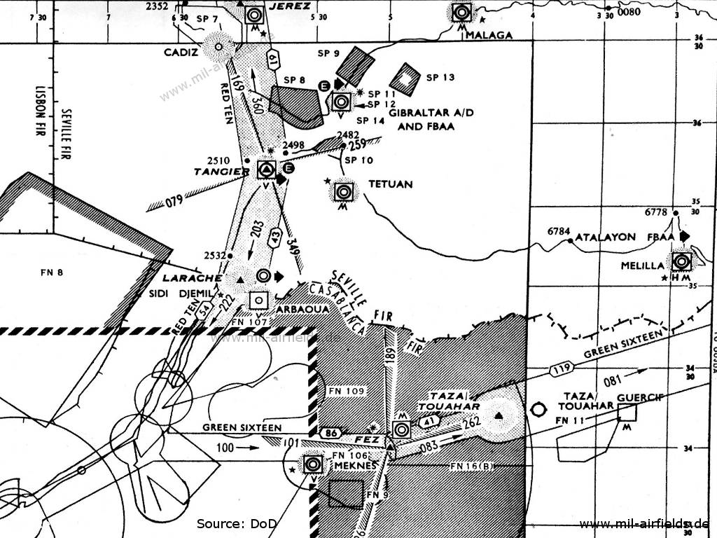
Gibraltar (Source: DoD)
Explanations
![]()
Directory of aeronautical radio beacons
For historical information only, do not use for navigation or aviation purposes!
Gibraltar: Airport (North Front)
Gibraltar: Eureka (Royal Air Force RAF)
N3609 W00521 (approx.), 002°/0.66 NM to field Google Maps
GB, 228R/223T MHz
N3609 W00521 (approx.), 002°/0.66 NM to field Google Maps
GB, 228R/223T MHz
For historical information only, do not use for navigation or aviation purposes!
Abbreviations
| approx. | approximately | |
| civ | civil | civil operator |
| GP | Glide path | Glide path transmitter |
| ILS | Instrument Landing System | (Approach and landing aid) |
| IM | Inner Marker | Marker beacon just in front the runway |
| kHz | Kilohertz | (Unit for frequency) |
| L | Locator | Non-directional beacon for the approach |
| LLZ | Localizer | Localizer transmitter |
| LMM | Locator Middle Marker | Combination of Middle Marker and Locator |
| LOM | Locator Outer Marker | Combination of Outer Marker and Locator |
| m | Meter | (Unit for length) |
| MHz | Megahertz | (Unit for frequency) |
| mil | military | military operator |
| MM | Middle Marker | Marker beacon |
| NDB | Non-directional beacon | Non-directional beacon on long or medium waves |
| NM | Nautical Miles | (Unit for length) |
| OM | Outer Marker | Marker beacon |
| PRMG | ПРМГ Посадочная радиомаячная группа | Soviet / russian military instrument landing system |
| RSBN | РСБН Rадиотехническая система ближней навигации | Soviet / russian military radio navigation system |
| SBA | Standard Beam Approach | Approach system, Lorenz system, predecessor of the ILS |
| THR | Threshold | Runway threshold (most often with number of runway) |
| transf. | transformed | Coordinates were converted from a different reference system, therefore there may be deviations. |
| VAR | Visual-Aural Rnange | |
| VOR | VHF Omnidirectional Radio Range | |
| W | Watt | (Unit for power) |
| WGS84 | World Geodetic System 1984 | (geospatial reference system, GPS coordinates) |
Recommended


Image credits are shown on the respective target page, click on the preview to open it.