Zurich Kloten Airport
Historical approach and aerodrome charts
For historical information only, do not use for navigation or aviation purposes!
| Coordinates | N472728 E0083320 (WGS84) Google Maps |
Airfield
Location Indicator: LSZH
In the 1950s
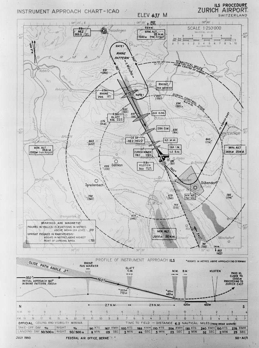
ILS approach runway 16 (July 1950) - From the combination of an Instrument Landing System (ILS) and a Standard Beam Approach (SBA), plus an additional Fan Marker, there are 6 marker beacons on the final approach: Fan Marker Rhine, ILS Outer Marker (ILS O.M.), SBA Outer Marker (SBA O.M.), ILS Middle Marker (ILS M.M.) as well as ILS Boundary Marker (ILS B.M.) und SBA Inner Marker (SBA I.M.), the last two at the same place. (Source: ETH-Bibliothek Zürich,
Bildarchiv/Stiftung Luftbild
Schweiz / Fotograf:
Swissair /
LBS_SR03-05689, License CC
BY-SA 4.0)

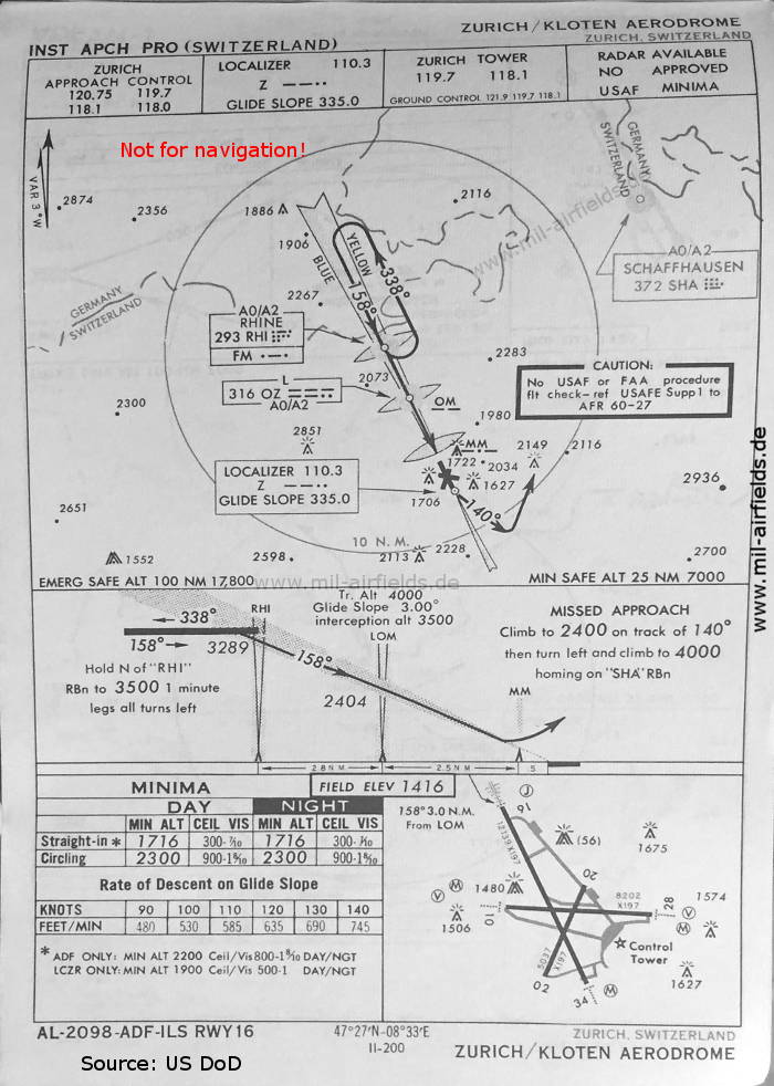
NDB approach runway 16 (March 1954) - Airfields in the vicinity: Dällikon (closed today), Dübendorf, Spreitenbach (also closed today). In contrast to the Glatt and Rhine beacons, the Trasadingen beacon does not seem to have been located exactly on the extended runway center line, but somewhat to the east of it. (Source: US DoD)
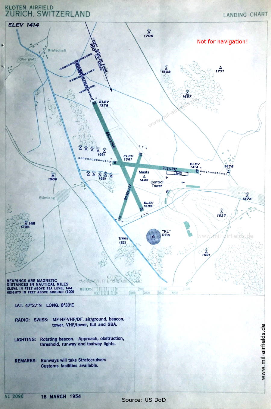
Airport (March 1954) - The beacon "KL" was located south of the beginning of runway 34. Later the runway was extended in this direction. (Source: US DoD)
In the 1960s
NDB/ILS approach runway 16 (May 1966) (Source: US DoD)
Index to the objects shown on the maps
Aerodromes:
- Dällikon, Dübendorf, Spreitenbach, Zürich-Kloten
Airspace:
- Danger Area
Radio beacons:
- Glatt NDB "OZ"
- Kloten NDB "KL"
- Rhine NDB "RHI", "RN", Fan Marker
- Schaffhausen NDB "SHA"
- Trasadingen NDB "HEZ"
- Zürich ILS "Z", Outer Marker, Middle Marker
- Zürich East NDB "ZE"
Air traffic control
- Zürich Approach Control, Zürich Tower
Source for all maps, if not marked otherwise: US Department of Defense (US DoD)
Title image: Douglas DC-4-1009 A, HB-ILI "Basel/Schwyz" in front of the terminal building Zürich-Kloten (March 1954). Source: ETH-Bibliothek Zürich, Bildarchiv/Stiftung Luftbild Schweiz / Fotograf: Swissair / LBS_SR03-06391, License CC BY-SA 4.0
Recommended

Image credits are shown on the respective target page, click on the preview to open it.
Navigation
Historical approach and aerodrome charts - Switzerland