For historical information only, do not use for navigation or aviation purposes!
| Coordinates | N534331 E0133543 (WGS84) Google Maps (approximate location) |
| Former East Germany (GDR) | District of Neubrandenburg |
| Federal state | Mecklenburg-Vorpommern (Mecklenburg-Western Pomerania) |
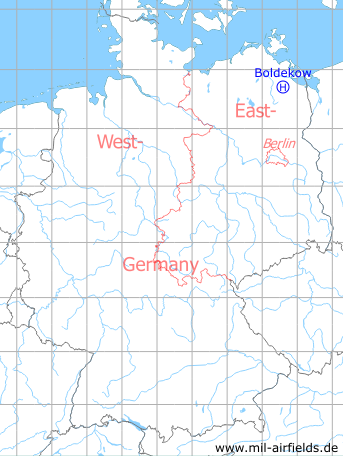
Germany during the Cold War Map
The history of the Cold War airfields: Boldekow
Location of airfield
Center of Boldekow, east of Federal Road B 197.
Usage during the Cold War
Helipad 3385 for Rear Unit of 3rd Air Defense Division (3. LVD) of former East German Air Force (NVA LSK/LV).
Use today
Closed.
Runways, taxiways, aprons
Dimensions: 100 m x 80 m,
Main takeoff and landing direction: 60°,
Surface: Gras (athletic field),
Capacity: 1 helicopter.
Main takeoff and landing direction: 60°,
Surface: Gras (athletic field),
Capacity: 1 helicopter.
Airspace and procedures
Usable at day during good weather conditions.
Alert time: 60 minutes (after deployment).
Alert time: 60 minutes (after deployment).
Obstacles
None.
Airfields in the vicinity
- 320°/6km Spantekow: Helipad 3386 (HSLP 3386)
- 022°/13km Anklam: Airfield
- 121°/20km Eichhof: Helipad 3334 (HSLP / HLP 3334)
- 186°/22km Ulrichshof: Helipad 3014 (HSLP / HLP 3014)
- 201°/22km Katzenhagen: Helipad 3302 (HSLP / HLP 3302)
- 234°/23km Neubrandenburg: Air Base (Trollenhagen)
- 213°/24km Pragsdorf: Helipad 3350 (HSLP / HLP 3350)
Categories
Military Airfields GermanyMilitary Airfields in former East GermanyHelipads of former National People's ArmyRecommended
Image credits are shown on the respective target page, click on the preview to open it.
 Follow mil-airfields on Facebook