For historical information only, do not use for navigation or aviation purposes!
| Coordinates | N504246 E0133044 ca. (WGS84) Google Maps (approximate location) |
| Former East Germany (GDR) | District of Karl-Marx-Stadt |
| Federal state | Sachsen (Saxony) |

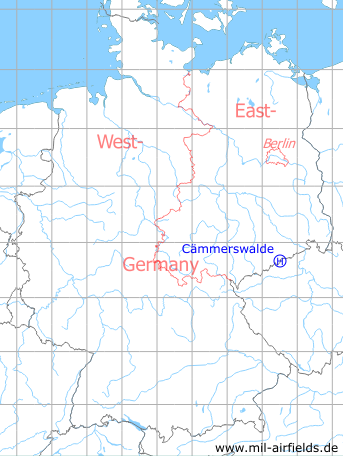
Germany during the Cold War Map
The history of the Cold War airfields: Cämmerswalde
Location of airfield
Northeastern corner of Cammerswalde
Usage during the Cold War
Helipad 1018 for Sub Depot 2 or Signals Depot 2 (TL-2/NGL-2) of former East German Ministry of National Defense (MfNV).
Use today
Closed.
Runways, taxiways, aprons
Dimensions: 100 m x 500 m,
main takeoff and landing direction: 210°,
surface: farmland,
usable without crop damage,
capacity: 1 helicopter.
main takeoff and landing direction: 210°,
surface: farmland,
usable without crop damage,
capacity: 1 helicopter.
Telephone
Fe-Feldverbindung 200 m auf Fe-Vermittlung, OB 62-10 auf dieser HADP und Stabsnetz.
TL-2/NGL-2: Sondernetz/Stabsnetz S1: 35672p, Tarnname: Großlautsprecher 12
Airspace and procedures
Usable at day and night during good weather conditions.
Alert time: 60 minutes.
Alert time: 60 minutes.
Units
Cämmerswalde was base for the sub-depot 2 of Signals Depot 2 (Nachrichtengerätelager 2. The NGL-2 was directly subordinated to the Ministry of Defense.
Sub-depot 2:
- Postal Address: PO box 26226
- Installation: Hauptstr. 37A, Cämmerswalde
- National People's Army installation ID: 14/133
Sub-depot 2:
- Postal Address: PO box 26226
- Installation: Hauptstr. 37A, Cämmerswalde
- National People's Army installation ID: 14/133