For historical information only, do not use for navigation or aviation purposes!
| Coordinates | N510804 E0134605 (WGS84) Google Maps |
| Elevation | 230 m |
| Former East Germany (GDR) | District of Dresden |
| Federal state | Sachsen (Saxony) |
| Region | Elbe |
| Location indicator | EDXD (196x), ETDN (-199x), EDDC (199x-) |
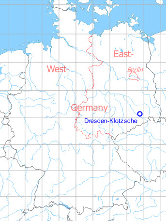
Germany during the Cold War Map
The history of the Cold War airfields: Dresden
Contents
Page 1: From the beginnings to the 1960s
Page 2: From the 1970s until today ← you are here
Page 3: Dresden Klotzsche Airport
In the 1970s
Situation
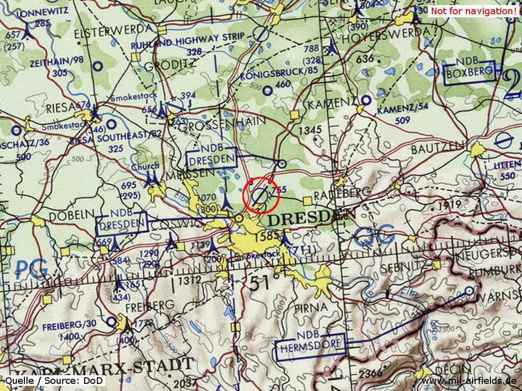
Dresden Klotzsche Airport on a map of the US Department of Defense from 1972
Source: ONC E-2 (1972), Perry-Castañeda Library Map Collection, University of Texas at Austin /PCL MC/
Overview
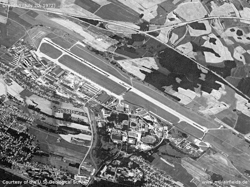
Dresden Klotzsche on a US satellite image from July 20, 1972 - The viewing direction is west.
Source: U.S. Geological Survey
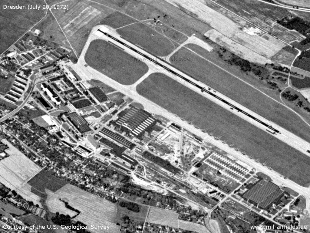
Enlargement: Southern part - Opposite the hangars on the edge of the taxiway are around 13 aircraft, probably 12 Il-14s and one An-2 from the National People's Army (NVA).
Source: U.S. Geological Survey
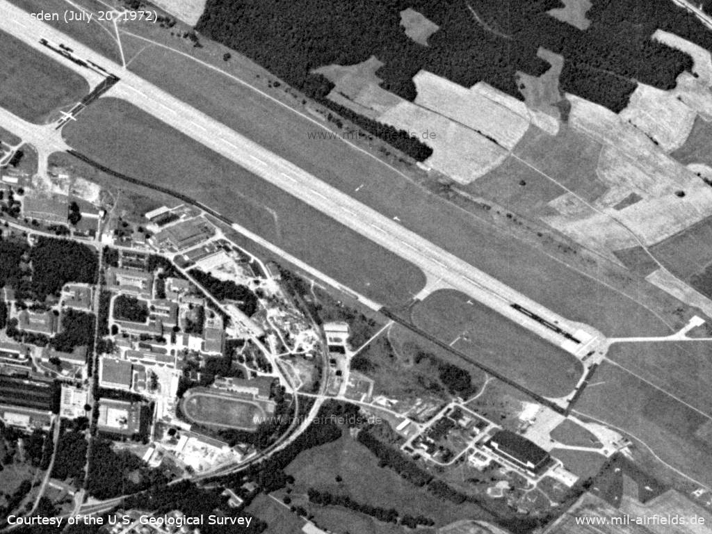
Enlargement: Northern part - A larger transport aircraft is parked on the center taxiway to the runway
Source: U.S. Geological Survey
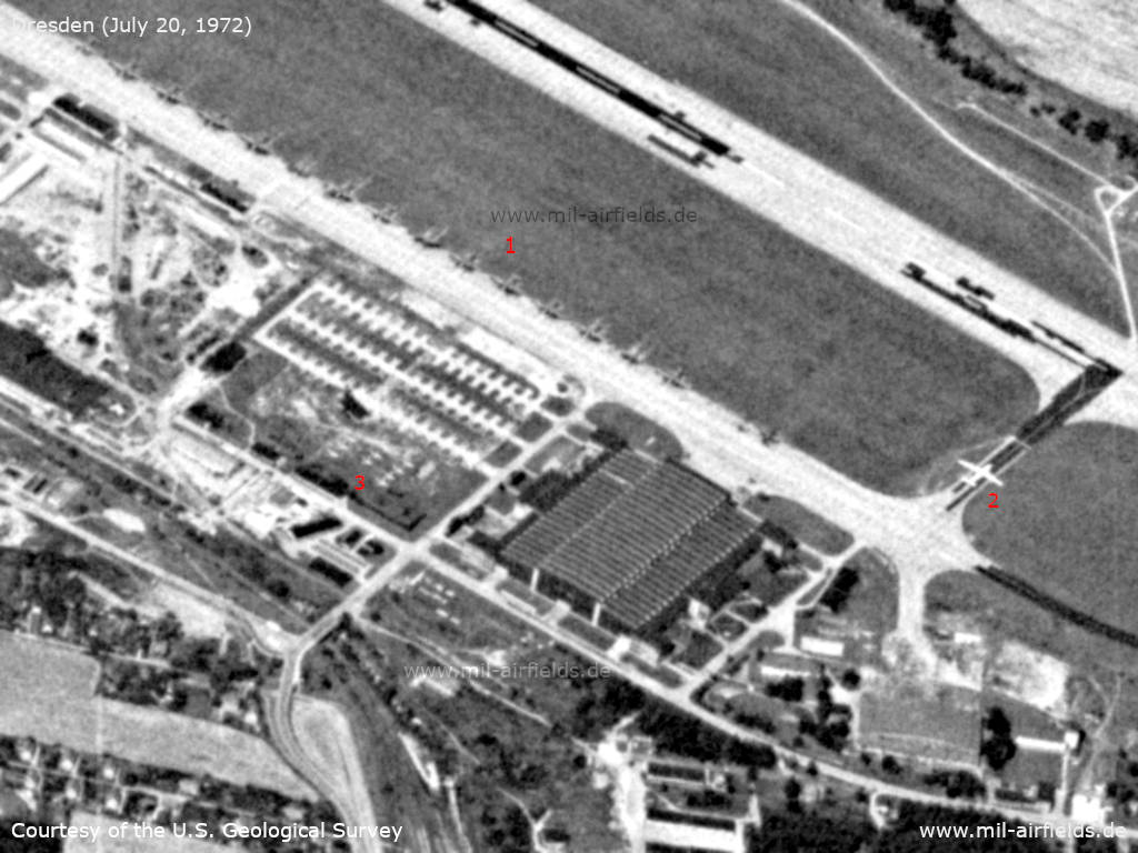
Enlargement: Planes - (1): East Germany military transport aircraft; (2): larger transport plane on taxiway; (3): There are 9 fighter planes in the grass in this area.
Source: U.S. Geological Survey
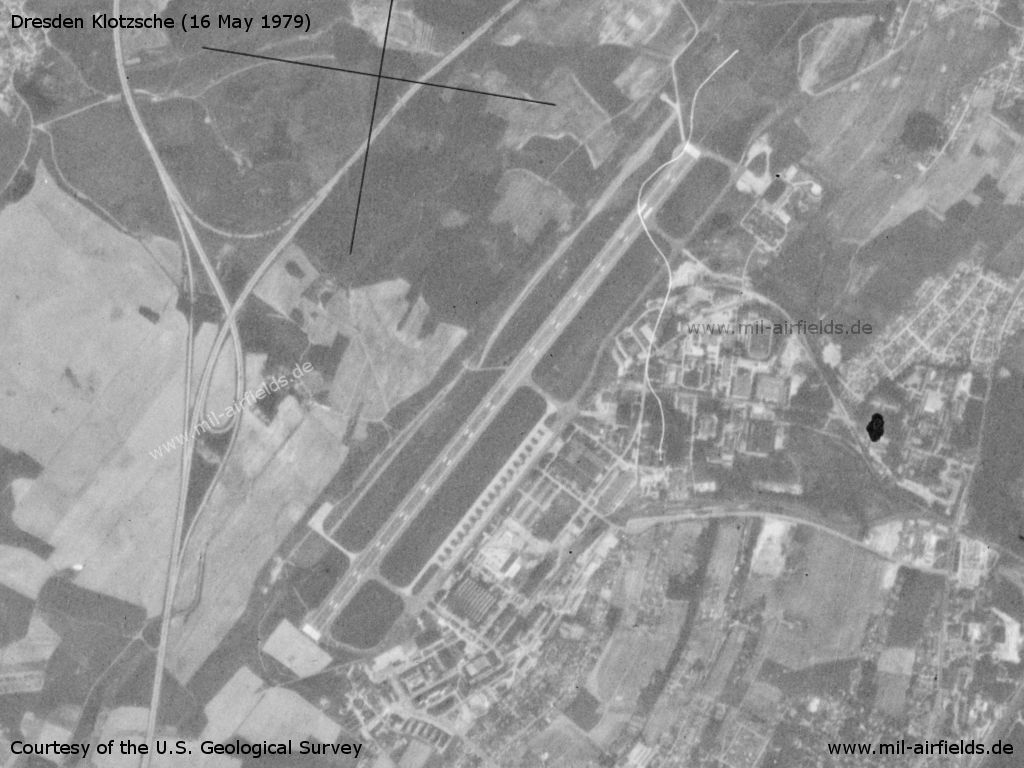
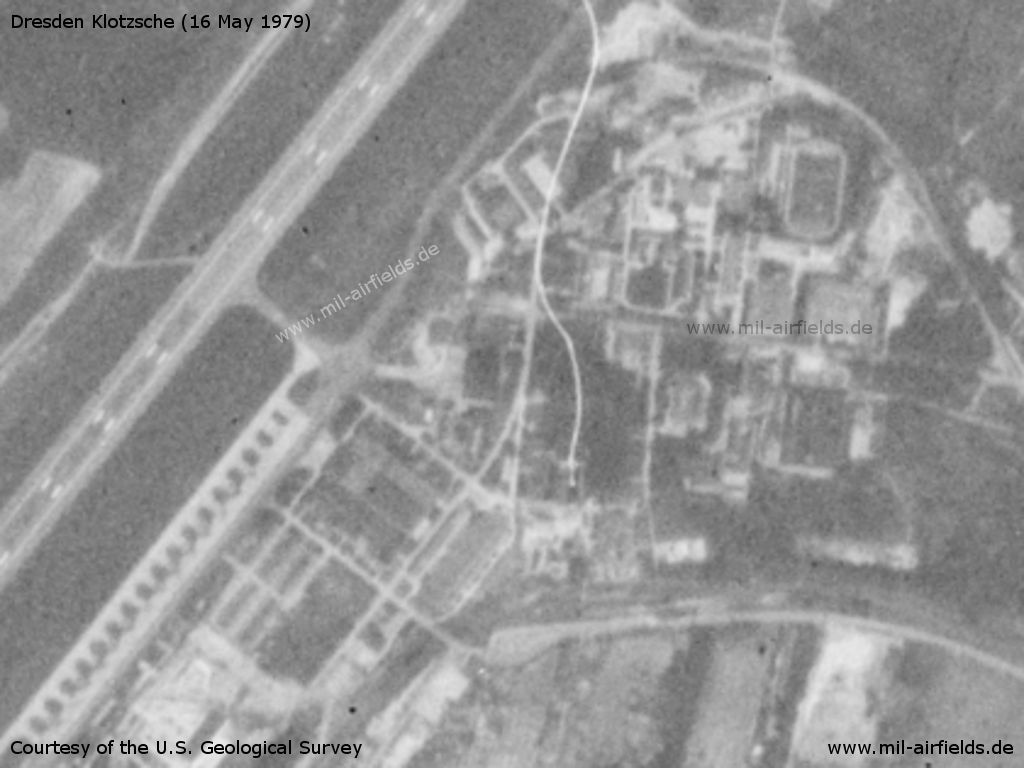
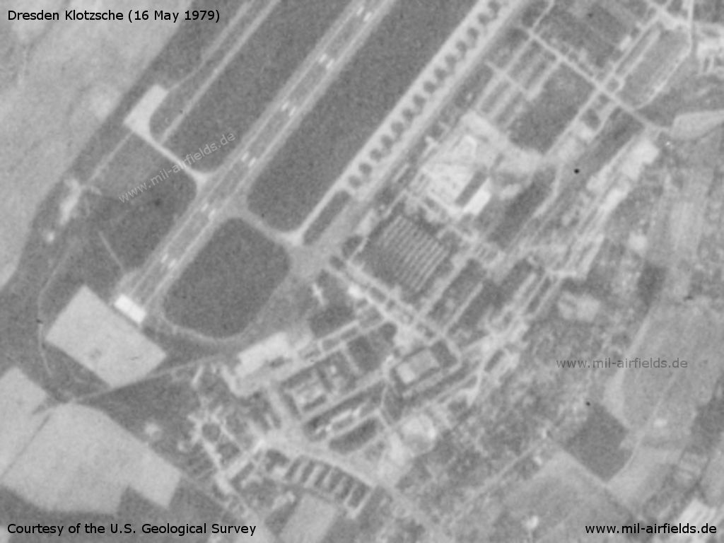
Dresden Klotzsche Airport on a US satellite image from 16 May 1979
Source: U.S. Geological Survey
The northern part
Source: U.S. Geological Survey
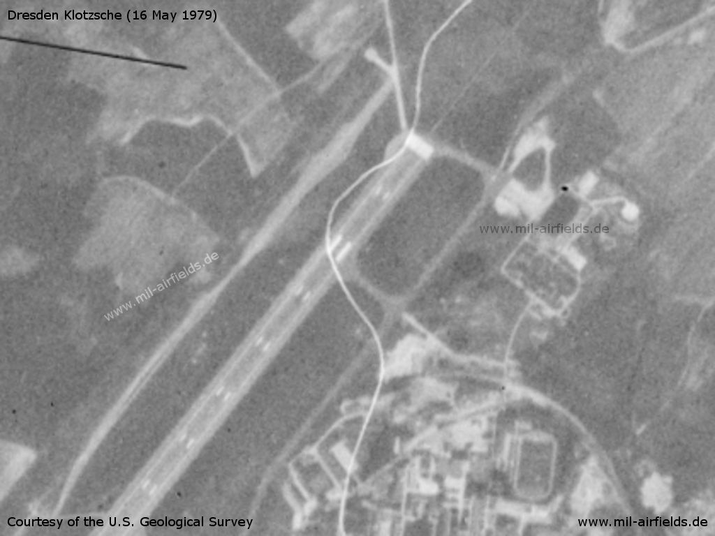
Central part - The ladder-shaped area at the left bottom are the newly created parking pads for the transport aircraft Il-14 and later An-26 of the East German National People's Army NVA.
Source: U.S. Geological Survey
Southern part with the airport of the East German Interflug
Source: U.S. Geological Survey
Runways
Data for the year 1976:
- 04/22: 2500 m x 80 m
- 04/22: 1000 m x 100 m Grass Emergency strip, northwest of RWY
Units
Matthias Behlert schreibt über die Zeit von Anfang der 1970er Jahre bis 1974:
Dresden-Klotzsche wurde auch von der GST als Segelflugplatz genutzt. Gestartet und gelandet wurde auf der Grasnarbe neben dem Rollfeld. Auch hier fand überwiegend Windenschlepp statt; einige Male im Jahr stand jedoch ein Schleppflugzeug aus Bautzen-Klix zur Verfügung. Die Nutzungsrechte am Flughafen waren zu jener Zeit folgendermaßen gestaffelt:
1. NVA
2. Flugzeugwerft
3. Interflug
4. GST
Die Interflug stellte für uns Segelflieger kaum ein Problem dar, denn zu jener Zeit gab es wöchentlich nur etwa 20 Linienflüge von und nach Dresden, die alle Mo-Fr stattfanden. Ein einziges Mal habe ich es erlebt, dass Dresden-Klotzsche wetterbedingt als Ausweichflughafen für Berlin-Schönefeld herhalten musste; da ging es dann auf der Rollbahn plötzlich hoch her, und Segelfliegen war natürlich nicht möglich. Auch die Flugzeugwerft legte uns keine Steine in den Weg. Lediglich die NVA hatte an 5-6 Wochenenden pro Saison etwas dagegen, dass wir flogen.
Images
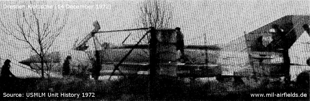
Camouflaged MiG-21 Fishbed with East German markings - Picture taken by the US Military Liaison Mission on 14 December 1972. This was the seventh such camouflaged aircraft observed at this airfield, but the first time it had been able to identify the camouflaged planes as East German. It had previously suspected that the camouflaged aircraft seen here were being prepared for delivery to Arab forces in the Middle East. At the time of this observation, an An-12 CUB subordinate to the Egyptian Air Force was also parked on the field. The relationship between the Egyptian aircraft and the camouflaged aircraft, if any, has not been established.
Source: USMLM Unit History 1972
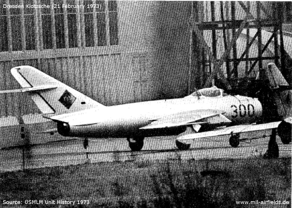
MiG-17 Fresco of the East German Air Force - The aircraft was photographed on 21 February 1973 by the US Military Liaison Mission. The wing pylon is attached at an unusual point.
Source: USMLM Unit History 1973
In the 1980s/early 1990s
Overview
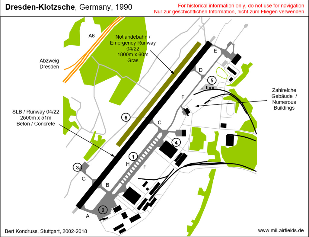
| A, B, C, D, E, F, G | Taxiway designator |
| (1) | Military ramp |
| (2) | Civil ramp |
| (3) | Ramp 3 |
| (4) | Control Tower |
| (5) | Fuel Depot |
| (6) | RSBN (TACAN-like navigation system) |
Runways
Data for the year 1985:
- 04/22: 2500 m x 80 m Asphalt
- 04/22 Grass Emergency
Data for the year 1989 after reconstruction of runway and reducing the width:
- 04/22: 2500 m x 51 m Concrete
- 04/22: 1800 m x 60 m Grass Emergency
Radio beacons
Data for the year 1989:
- RSBN: Channel 39 "FO", N510758 E0134557 (S43/82)
- DME: Channel 116 "DSN"
- LOM 22 civ: 370 "FS", 7613 m to threshold 22
- LOM 22 mil: 834 "FO", 3800 m to threshold 22
- LMM 22 civ/mil: 407 "F", 1245 m to threshold 22
- ILS 22: 109,7 "IFS"
- LOM 04 civ: 342 "GPZ", 12602 m to threshold 04
- LOM 04 mil: 376 "KW", 3728 m to threshold 04
- LMM 04 civ/mil: 407 "K", 1065 m to threshold 04
Die Kennungen der Funkfeuer FO und F (Hauptlanderichtung) wurden wie üblich aus dem ersten und letzten Buchstaben des Rufzeichens "FIGARO" abgeleitet.
Die Funknavigationsausrüstung für den Anflug auf Dresden war ungewöhnlich: sie bestand aus jeweils 3 Funkfeuern für jede Anflugrichtung. Das Konstrukt entstand durch die Überlappung jeweils eines militärischen und eines zivilen Systems, denn das äußere Funkfeuer hat im zivilen System einen signifikant größeren Normabstand von der Landebahn (ca. 3..4 Seemeilen) als im militärischen System des Warschauer Paktes (4 km).
Anflugrichtung 221°:
- Militärisches System mit den Funkfeuern FO und F
- Ziviles System mit den Funkfeuern FS und F
Das Funkfeuer F war also Bestandteil sowohl des zivilen als auch des militärischen Systems. Das Funkfeuer FS war gleichzeitig Streckenfunkfeuer für die Luftstraße B52.
- Militärisches System mit den Funkfeuern FO und F
- Ziviles System mit den Funkfeuern FS und F
Das Funkfeuer F war also Bestandteil sowohl des zivilen als auch des militärischen Systems. Das Funkfeuer FS war gleichzeitig Streckenfunkfeuer für die Luftstraße B52.
Anflugrichtung 041°:
- Militärisches System mit den Funkfeuern KW und K
- Ziviles System mit den Funkfeuern GPZ und K
Das Funkfeuer K war also Bestandteil sowohl des zivilen als auch des militärischen Systems. Das Funkfeuer GPZ war gleichzeitig Streckenfunkfeuer für die Luftstraßen B51 und B52 und hatte vermutlich deshalb einen deutlich größeren Abstand zur Landebahn 04 als üblich.
Ungefähr ab Mitte der 1980er Jahre sah der Landeanflug auf die Bahn 22 eine Peilung zum Funkfeuer "KZ" vor, dem Fernfunkfeuer vom Kamenz: Airfield. Damit wurden Frequenz und Kennung dieses militärischen Funkfeuers international veröffentlicht, was bei der sonst so übertriebenen Geheimhaltung in der DDR schon sehr bemerkenswert war.
Ausstattung des Flugplatzes mit Instrumentenlandesystemen
Noch Anfang der 1980er Jahre war der Platz anstelle eines ILS nur mit einem sowjetischen Landesystem KGSP/KRM für die Landebahn 04 ausgestattet.
Radio communication
Data for the 1980s:
Military
The military call sign of the airfield was FIGARO; Tower: FIGARO-START (frequencies 132,0 and 124,0 MHz); Direction finder: FIGARO-PELENG (130,0 MHz).
Civil
The civil calls sign were DRESDEN APPROACH and DRESDEN TOWER (both 127,7 MHz); PAR: DRESDEN PRECISION (118,0 MHz).
Telephone
Data for the 1980s:
Sondernetz S1
The number in Sondernetz/Stabsnetz S1 was 9321. The call signs were NEIGUNGSEHE (switchboard) and GERÄT (command post). Passport check by Ministry of State Security: 7-9724-2878.
Former East German public telephone network
Airport: Dresden 58941, 585171
Interflug: Dresden 583141
Interflug: Dresden 583141
Teletype
Data for the 1980s:
Former East German Sondernetz/Stabsnetz S1:
Passport checkpoint: 939-374-44, call sign guest-dfh.
Former East German public teletype network:
Interflug: Telex 026 036
Maps
Maps from the "Directory 012" (Verzeichnis 012), containing aeronautical information about military airfields of the former East Germany National People's Army (NVA) and Border Troops (GT). The document was classified as "secret".
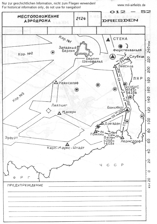
Location of airfield with radio beacons and airways.
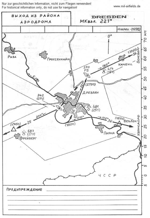
Departure routes for main landing direction 221°
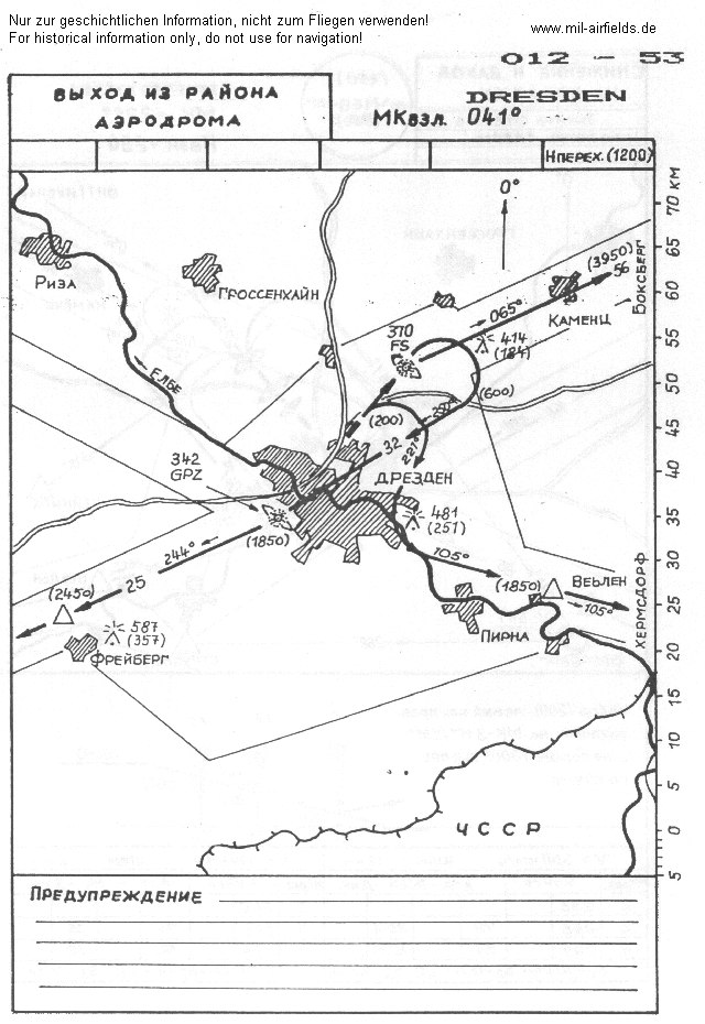
Departure routes for secondary landing direction 041°
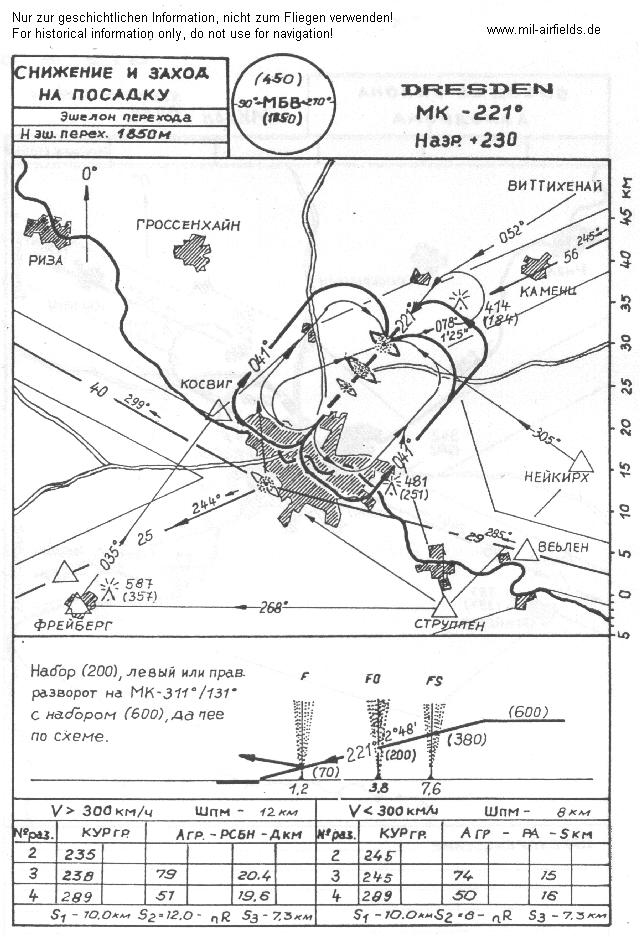
Approach in main landing direction 221°. The three beacons FS, FO und F are good visible..
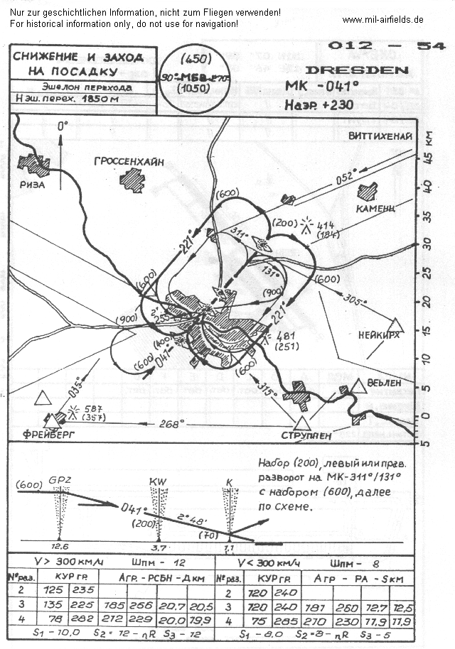
Approach in secondary landing direction 041°
Visual approach and departure routes
Data for the years 1985..1990:
Dresden Airport - Moritzburg (departure only)
Dresden Airport - Radeburg (departure only)
Dresden Airport - Wachau - Großnaundorf - Königsbrück
Dresden Airport - Wachau - Dittersbach - Stadt Wehlen - Struppen - Barrage-Malter - Freiberg
Connections between visual approach and departure routes and local flying routes
Data for the year 1982:
Freiberg at the Local Flying Route No. 34 (leg Mutzschen - Freiberg)
Radeburg at the Local Flying Route No. 14 (leg Radeburg - Coswig)
Moritzburg, shortest track to Local Flying Route No. 14 (leg Radeburg - Coswig);
Wehlen, point at the Local Flying Route.
Units
Units 1990:
- Transportfliegerstaffel 24 (TS-24, Postfach PF 33608)
- Fliegertechnisches Bataillon 24 (FTB-24, PF 43803)
- Luftaufklärungszentrale (PF 63276)
- Transportfliegerstaffel 24 (TS-24, Postfach PF 33608)
- Fliegertechnisches Bataillon 24 (FTB-24, PF 43803)
- Luftaufklärungszentrale (PF 63276)
Real property
Data for the year 1990:
Installations with former East German installation ID:
12/025: Airfield
12/170: Communication installation TS-24 (0,4 ha, 9 Unterkunftsplätze)
12/171: Air traffic control installation TS-24 (1,9 ha, 12 U)
12/294: Radio Beacon (3 ha), Address: Dresden Wilder Mann, An der Kalkreutherstr.
12/025: Airfield
12/170: Communication installation TS-24 (0,4 ha, 9 Unterkunftsplätze)
12/171: Air traffic control installation TS-24 (1,9 ha, 12 U)
12/294: Radio Beacon (3 ha), Address: Dresden Wilder Mann, An der Kalkreutherstr.
The installation IDs (12/025 etc) were made of the district number (12=District of Dresden) and a sequence number.
History
13.06.1990 Vorkommnis K-1 bei Überführungsflug nach Dresden. Über dem Fernfunkfeuer bemerkt der Flugzeugführer eine An-26 im Landeanflug. Einleitung einer zweiten Platzrunde und Landung mit 250 Litern Kraftstoff. Ursache: Flugleiter war überfordert. Mangel in der Vorbereitung der Führung, mangelnde Qualifizierung des Personals.
In the 1990s/2000s
Use
For a short period used by German Bundeswehr and for dismanteling of East German fighter aircrafts.
Today
Use
Airport.
Links
- http://www.skybird-ev.de/ - SKYBIRD - Pro Luftfahrt e.V. With movements since 1956 and historic air traffic control radio recordings from 1960
- http://www.fliegerhorste.de/dresden.htm - Dresden - Luftkriegsschule 1
- LUROKOs An-26 Page - Informations about An-26 and TS-24
- /BYUBYU/:
http://lib.byu.edu/collections/german-maps/http://... - German Maps (Topographische Karte 1:25,000)German Maps (Topographische Karte 1:25,000) - http://www.history.hqusareur.army.mil/uslmannual.htm (offline): USMLM Unit History 1971 - Sighting of a egypt An-12 at Dresden on 08 july 1971
- http://www.history.hqusareur.army.mil/uslmannual.htm (offline): USMLM Unit History 1972 - Sighting of an An-12 with arab markings and a MiG-21 in camouflaged colours.
- http://www.history.hqusareur.army.mil/uslmannual.htm (offline): USMLM Unit History 1973 - MiG-17 with modified pylons.
- Dresden Airport - Official homepage of Dresden airport
- Sachsenbunker - Radio beacons at Dresden airport.
Bibliography
- Grenzdörfer, Joachim; Seifert, Karl-Dieter: "Geschichte der ostdeutschen Verkehrsflughäfen" Bernard & Graefe Verlag, Bonn, 1997 - 15 pages with description, pictures and maps.
- Freundt, Lutz: "Sowjetische Fliegerkräfte in Deutschland 1945-1994, Band 1" Freundt Eigenverlag, Diepholz 1998 - Short description about usage after the war; part of an aerial picture from 1953.
- Bußmann, Kleest, Freundt: ""11-80, katapultieren Sie!"" AeroLit - Verlag und Medienvertrieb, Berlin, 2004 - Short descriptions of aircraft accidents at Dresden in 1963, 1964, 1966 and 1967
- Billig, Detlef; Meyer, Manfred: "Flugzeuge der DDR, I. Band bis 1962" TOM Modellbau, Friedland, 2002 - Informationens and many pictures about construction of Il-14 and Baade 152 at Dresden
Related topics
Airfields in the vicinity
- 030°/3km Weixdorf: Highway Strip (Autobahnabschnitt ABA Dresden, Ottendorf-Okrilla Highway Strip)
- 200°/4km Dresden: Heller Heliport (Hellerau)
- 033°/16km Königsbrück: Agricultural Airfield, Helipad 3044 (HSLP / HLP 3044)
- 093°/20km Großröhrsdorf: Helipad 3138 (HSLP / HLP 3138)
- 261°/21km Naustadt: Helipad 3164 (HSLP / HLP 3164)
Categories
Military Airfields GermanyMilitary Airfields in former East GermanyAirfields of the Soviet Forces in GermanyAir bases of former National People's ArmyRecommended
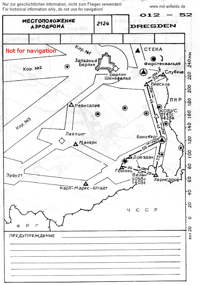
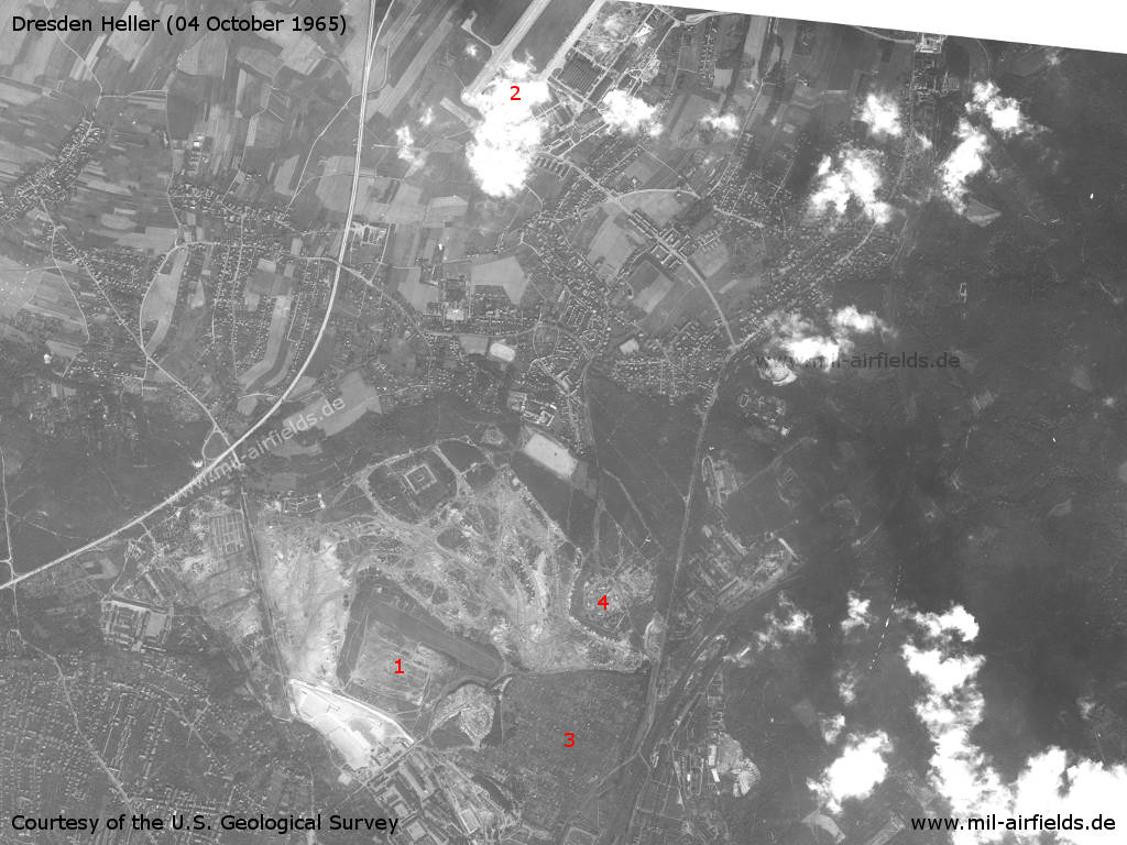
Image credits are shown on the respective target page, click on the preview to open it.
Contents
Page 1: From the beginnings to the 1960s
Page 2: From the 1970s until today ← you are here
Page 3: Dresden Klotzsche Airport
 Follow mil-airfields on Facebook